:quality(70)/cloudfront-us-east-1.images.arcpublishing.com/cmg/WW5AJL3ARQUGDQMAQUNSFX4CLE.jpg)
Jacksonville, Fl. — The “Buresh Bottom Line”: Always be prepared!.....First Alert Hurricane Survival Guide... City of Jacksonville Preparedness Guide... Georgia Hurricane Guide.
STAY INFORMED: Get the * FREE * First Alert Weather app
FREE NEWS UPDATES, ALERTS: Action News Jax app for Apple | For Android
WATCH “Talking & Tracking the Tropics: The Science Behind the Season”
WATCH “Preparing for the Storm”
READ the First Alert Hurricane Center “Survival Guide”
***** ALWAYS CHECK & RE-CHECK THE LATEST FORECAST & UPDATES! *****
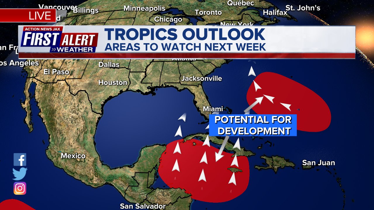
The Caribbean/Gulf of Mexico & SW Atlantic will remain the areas to keep an eye on over the next couple of weeks (climatologically favored too). However, there is nothing immediately threatening through this week with the exception of Bermuda (t.d. #27).
Areas to Watch:
(1) low pressure over the Central Atlantic evolved from an upper low & has become t.d. #27. As #27 strengthens, it will drift some semblance of west. Eventually... the tropical cyclone should turn more northwest then north - & eventually northeast - over the West Atlantic staying east of the U.S. east coast but likely to become an “issue” for Bermuda late in the week/upcoming weekend. It looks like t.d. #27 will become a potent hurricane over the Central Atlantic.
(2) Caribbean - while forecast models have been reasonably consistent in developing low pressure & an eventual tropical cyclone over/near the Caribbean that then moves north/northeast between Oct. 21st & 28th, there has been horrible run to run (individual model output) consistency. Where the potential system would go & how strong it might be has varied considerably from one day to the next with a tendency to delay the development some. The Caribbean is an area favored for late season tropical development + the GFS has been decent at picking up on long range development this season (not necessarily the long term details/track). The European & especially UKMET at least indicate lower pressures but are otherwise - at least so far - not as aggressive on this potential feature & have a tendency to be farther west & north.... + are also delaying what development they are showing. The latter is quite plausible (later/slower developing system). This kind of set-up is notorious for slow development but once established, a strong tropical cyclone can evolve that then gets pulled north or northeast due to the typically farther south latitude jet stream (vs. earlier in the season, especially Aug./Sept.).
This is a heads-up & ‘First Alert’ for the Caribbean & Southeast U.S./Eastern Gulf regarding tropical “trouble” late this week/next weekend &/or into the following week.
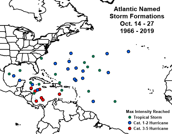
Where Atlantic tropical cyclones have formed mid to late Oct. since 1966, by Phil Klotzbach:
Satellite below shows an “unsettled” Caribbean/SW Atlantic/Bahamas... the t.d. #27 over the Central Atlantic far to the southeast of Bermuda... & a strong tropical wave that has emerged off the coast of Africa over the Eastern Atlantic but which has little chance to make it very far west....


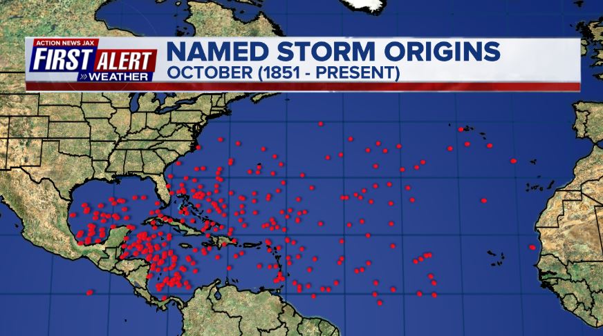
October tropical cyclone origin points are clustered over the Caribbean, Gulf of Mexico & SW Atlantic:
Atlantic Basin wave forecast for 24, 48 & 72 hours respectively (major wave action at Fl./Ga. beaches through early next week due to persistent brisk onshore flow (high pressure to the north) combined with easterly swells from distant Teddy:


:quality(70)/d1hfln2sfez66z.cloudfront.net/04-25-2024/t_927dce773846408d91e35a80df617dd2_name_file_960x540_1200_v3_1_.jpg)
:quality(70)/d1hfln2sfez66z.cloudfront.net/04-24-2024/t_d73855398dca4bf5a6e1eca4fedb0fdd_name_file_960x540_1200_v3_1_.jpg)
:quality(70)/cloudfront-us-east-1.images.arcpublishing.com/cmg/GUAD4ABRCRB4LJ6TP72IOU75WI.jpg)
:quality(70)/cloudfront-us-east-1.images.arcpublishing.com/cmg/5BGF6ZRBF5BH3JEEOYZ2JOLJAA.png)
:quality(70)/cloudfront-us-east-1.images.arcpublishing.com/cmg/UPSNZVHYKZE2VDSCN54C3FTF5E.png)