:quality(70)/cloudfront-us-east-1.images.arcpublishing.com/cmg/4BY52YP3URHB3CBG6342FEUNGQ.jpg)
Jacksonville, FL — “Talking the Tropics With Mike” updated everyday through Nov. 30th (the end of the Atlantic hurricane season). The next month or so will likely continue to be active - more in the previous “BB” * here *.
While a lot of print has been given to how active the Atlantic has been this season (for the 2nd year in a row), a good measure of global activity is the ACE - Accumulated Cyclone Energy. The definition from the Climate Prediction Center:
“The phrase “total overall seasonal activity” refers to the combined intensity and duration of Atlantic named storms and hurricanes occurring during the season. The measure of total seasonal activity used by NOAA is the
Accumulated Cyclone Energy: The ACE index is a wind energy index, defined as the sum of the squares of the maximum sustained surface wind speed (knots) measured every six hours for all named storms while they are at least tropical storm intensity.”
So - globally - the ACE has been below avg. The one basin that is above is the Atlantic Basin though even there the number is not astronomical. So we (Atlantic) have had a lot of storms but most have been short-lived & have lacked much punch despite 8 U.S. landfalls so far. Of course, there have been notable exceptions - Henri & especially Ida.

Next three images from CSU & Dr. Phil Klotzbach:


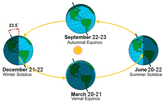
Welcome to the Autumnal Equinox! The hottest temps. of the year are behind us but trust me we still have plenty of high humidity to endure before we get sustained cooler air. I always like to say “wait til Halloween”. But the last week of Sept. will be nice & mild - overnight.

Since 1970 Jacksonville has endured about 7 more above avg. days per year (last 50 years):

Recall that the Northern Hemisphere seasons are dictated by the tilt of the earth toward (summer) or away (winter) from the sun:
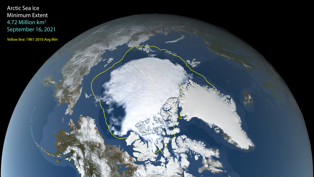
It looks like the arctic sea ice reached its seasonal minimum on Sept. 16th. From NASA:
“Satellite-based passive microwave images of the sea ice have provided a reliable tool for continuously monitoring changes in the Arctic ice since 1979. Every summer the Arctic ice cap melts down to what scientists call its “minimum” before colder weather begins to cause ice cover to increase. An analysis of satellite data by NASA and the National Snow and Ice Data Center (NSIDC) at the University of Colorado Boulder shows that the 2021 minimum extent, which was likely reached on Sept. 16, measured 1.82 million square miles (4.72 million square kilometers).
In an animation - click here - the daily Arctic sea ice and seasonal land cover change progress through time, from the yearly maximum ice extent on March 21 2021, through its minimum on September 16 2021. Over the water, Arctic sea ice changes from day to day showing a running 3-day minimum sea ice concentration in the region where the concentration is greater than 15%. The blueish white color of the sea ice is derived from a 3-day running minimum of the AMSR2 89 GHz brightness temperature. The yellow boundary shows the minimum extent averaged over the 30-year period from 1981 to 2010. Over the terrain, monthly data from the seasonal Blue Marble Next Generation fades slowly from month to month. The faint circle that appears periodically close to the pole is an artifact of the visualization process, and does not represent a real feature.
Sea ice in the Arctic appears to have hit its annual minimum extent on Sept. 16, after waning in the 2021 Northern Hemisphere spring and summer. The summertime extent is the 12th lowest in the satellite record, according to scientists at the NASA-supported National Snow and Ice Data Center and NASA.
This year, the minimum extent of Arctic sea ice dropped to 4.72 million square kilometers (1.82 million square miles). Sea ice extent is defined as the total area in which ice concentration is at least 15%.
The average September minimum extent record shows significant declines since satellites began measuring consistently in 1978. The last 15 years (2007 to 2021) are the lowest 15 minimum extents in the 43-year satellite record.”
©2021 Cox Media Group
:quality(70)/d1hfln2sfez66z.cloudfront.net/04-20-2024/t_50ad93a3ff19442c92d6e1ccd6123c3c_name_file_960x540_1200_v3_1_.jpg)
:quality(70)/d1hfln2sfez66z.cloudfront.net/04-19-2024/t_14ef6ae39b2e47568c35171ec8b4ffd8_name_file_960x540_1200_v3_1_.jpg)
:quality(70)/cloudfront-us-east-1.images.arcpublishing.com/cmg/N7YMXJTJYJEFBCXSUI6KPLO7OM.png)
:quality(70)/d1hfln2sfez66z.cloudfront.net/04-19-2024/t_fc027b22dc41498cbd1409c5f61588fd_name_file_960x540_1200_v3_1_.jpg)
:quality(70)/d1hfln2sfez66z.cloudfront.net/04-19-2024/t_744a0fe392b04fa194c322a11f1cea0c_name_file_960x540_1200_v3_1_.jpg)