:quality(70)/cloudfront-us-east-1.images.arcpublishing.com/cmg/4BY52YP3URHB3CBG6342FEUNGQ.jpg)
Jacksonville, FL — For Jacksonville specifically…. There were 31 record temps. for 2020 including 22 record highs, 8 record high overnight lows & a single record low.
:quality(70)/cloudfront-us-east-1.images.arcpublishing.com/cmg/UU7ZABD2WZH37HYNV4262WXJ2I.jpeg)
:quality(70)/cloudfront-us-east-1.images.arcpublishing.com/cmg/XRFF2WXBZFECNEEHYU7OJIQBFU.jpeg)
The year will end up with temps. above avg. by about 2-2.5 degrees… & rainfall about 4-5″ above avg. 3 months (June, July, Dec.) averaged temps. below avg.... 7 months had below avg. rainfall. Months below are followed by the difference in temps./rainfall from avg. + some (mostly local) highlights:
JANUARY…. +6.4 DEGREES / -3.12″
5th – 85 degrees – Daily record high (81/2015) & tie all-time Jan. record set on Jan. 30, 2013
11th – Low of 66 degrees – record high min. (65/1925)
12th – Low of 69 degrees – record high min. (65/1947)… record high of 84 (82/1949)… warmest Jan. day on record! – 76.5 degrees (75.0 degrees – Jan. 7, 1998)
13th – High of 84 degrees – record (82/2005)
14th – High of 82 degrees – record (81/2013)
15th – High of 83 degrees – ties record (1989)
FEBRUARY… +3.5 DEGREES / +1.06″
6th – High of 85 degrees ties record high set in 2008….. EF-0 tornado in Waycross, Ga. + a number of strong wind gusts across SE Ga./NE Fl. with squall line of t’storms. Pic below is in Waycross from Jax N.W.S.:
Tipped over semi on the Dames Point Bridge:

11th – High of 85 degrees – record (84/1939)…. Low of 65 degrees ties record high min. set in 2019
12th – High of 84 degrees ties record set in 2019
13th – High of 89 degrees! – record (85/1959)…. All time Feb. record high (88 degrees on the 24th, 1962 & on the 9th, 1937)
16th – Daytona 500 postponed by rain.
MARCH… +9.1 DEGREES / -2.22″
3rd – 4th – very early morning Tennessee tornado outbreak including Nashville – at least 22 killed. Pic below from East Nashville, N.W.S. Storm Suvey:
4th – High of 88 degrees – record (86/1997)
5th – High of 87 degrees – ties record (1997)
11th – Covid-19 declared to be a “pandemic”
13th – “The Players” cancelled due to Covid
15th – High of 90 degrees ties record high (1967)
25th – High of 91 degrees – record (90/1954)…. Ties all-time March record high (10th, 1974)
27th – High of 90 degrees – record (89/1991)
28th – High of 94 degrees! – record (89/2009)… all-time March record (91 on the 25th)
29th – High of 91 degrees – record (89/1991)
30th – High of 89 degrees – ties record high (1961)
31st – High of 89 degrees – record (88/2016)…. EF-0 at Mickler’s Landing
Avg. March high – 83.3 degrees – record (81.2 degrees/1945)…. 2nd warmest March on record – 70.8 degrees (71.4 degrees, 1945)… 9 record highs – most for any month on record in Jacksonville
APRIL… +3.3 DEGREES / +3.50″ (10th wettest April on record – 6.14″)
9th – High of 92 degrees – ties record (2011)
12-13th – 2-day tornado outbreak from Louisiana to Georgia to Tennessee & the Carolina’s kills at least 30
14th – Low of 71 degrees – record high min. (70/2019)
15th – 2.50″ of rain at JIA – daily record (2.08″/1929)… EF-0 tornado at 7:30am – Black Hammock Island - pic of damage below:

23rd – several SE Ga. tornadoes including EF-0 in Waycross, Ga. Photo below by Jack Miller not far from Waycross:

*** avg. temp. from Jan. 1 – April 30: 65.1 degrees/+5.6 degrees – warmest since at least 1971
MAY…. +0.7 DEGREES / -1.05″
16th – Crescent Beach rip current drowning… T.D. #1 then T.S. “Arthur” forms offshore east of Jacksonville
26th – 2-4″ of rain Eastern Duval to S’side to NAS Jax to N. Clay Co.
27th – T.S. “Bertha” forms off S. Carolina coast & moves ashore near Charleston late in the day
JUNE…. -0.4 DEGREES / +3.41″
1st – T.D. #3 forms – Bay of Campeche
2nd - #3 becomes “Cristobal”
3rd – Cristobal landfall at Atasta, Mexico w/ 60 mph winds.
7th – Jax/NE Fl. flooding with 2-12″ of rain…. T.S. Cristobal landfall southeast of New Orleans

16th – Low of 62 degrees – ties record (2002)
25th – Lots of 1 – 1.5″ hail Southern Duval, St. Johns Co. - Julington Creek hail:

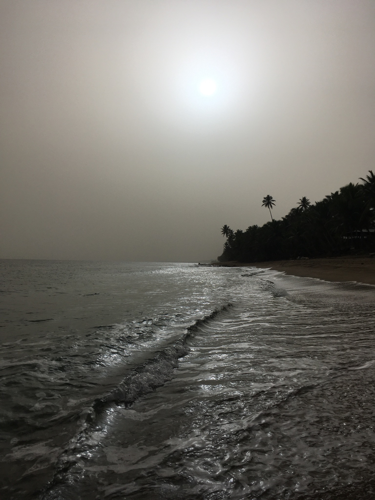
26th – Haze & low visibility to due large Saharan dust cloud in upper atmosphere. Photo from Paul Norton in Puerto Rico where the dust was especially thick (not unusual during June, & the dust diminished later in the hyper-active hurricane season).
30th – Strong afternoon storms drop trees in Orange Park
JULY… -0.10 DEGREES / -0.69″
10th – T.S. “Fay” landfall near Atlantic City, NJ…. 11th straight day w/ measurable rain at JIA – record is 17 straight days Aug. 30-Sept. 15, 2001
25th – Cat. 1 hurricane “Hanna” landfall near Corpus Christi, TX
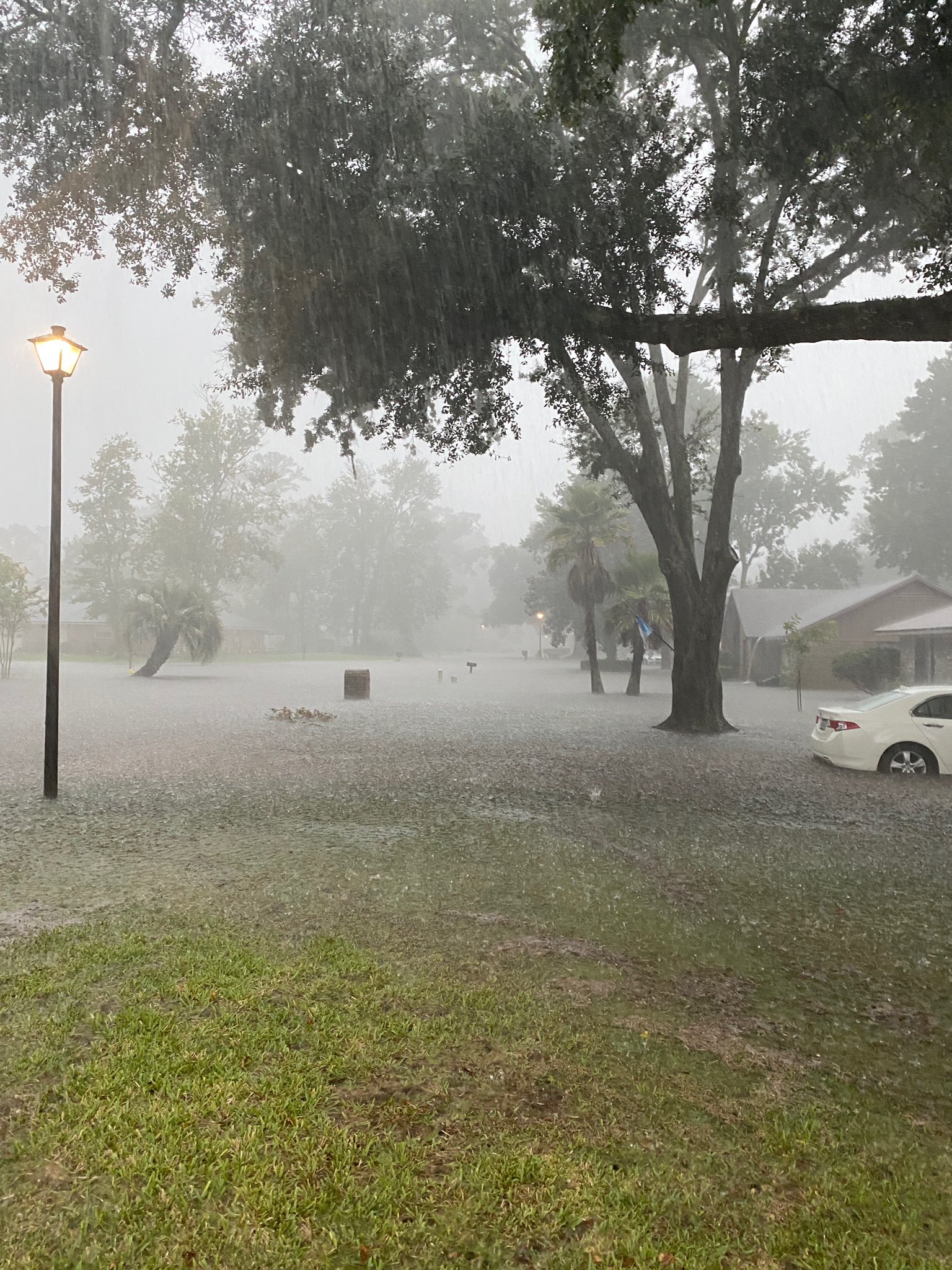
28th – 7.33″ of rain in Mandarin late afternoon storm/deluge
AUGUST… +0.4 DEGREES / +3.62″
1st – Cat. 1 hurricane Isaias landfall at Aboco Island, Bahamas
3rd – Closest t.s. Isaias approach to Jacksonville – 100 miles east of Jax Beach - no local damage.


4th – 1-2″ diameter hail Westside of Jax (rare for Aug. - only 3rd in the Aug. Florida data base with official 2″ diameter hail)… 4.7″ of rain in Normandy

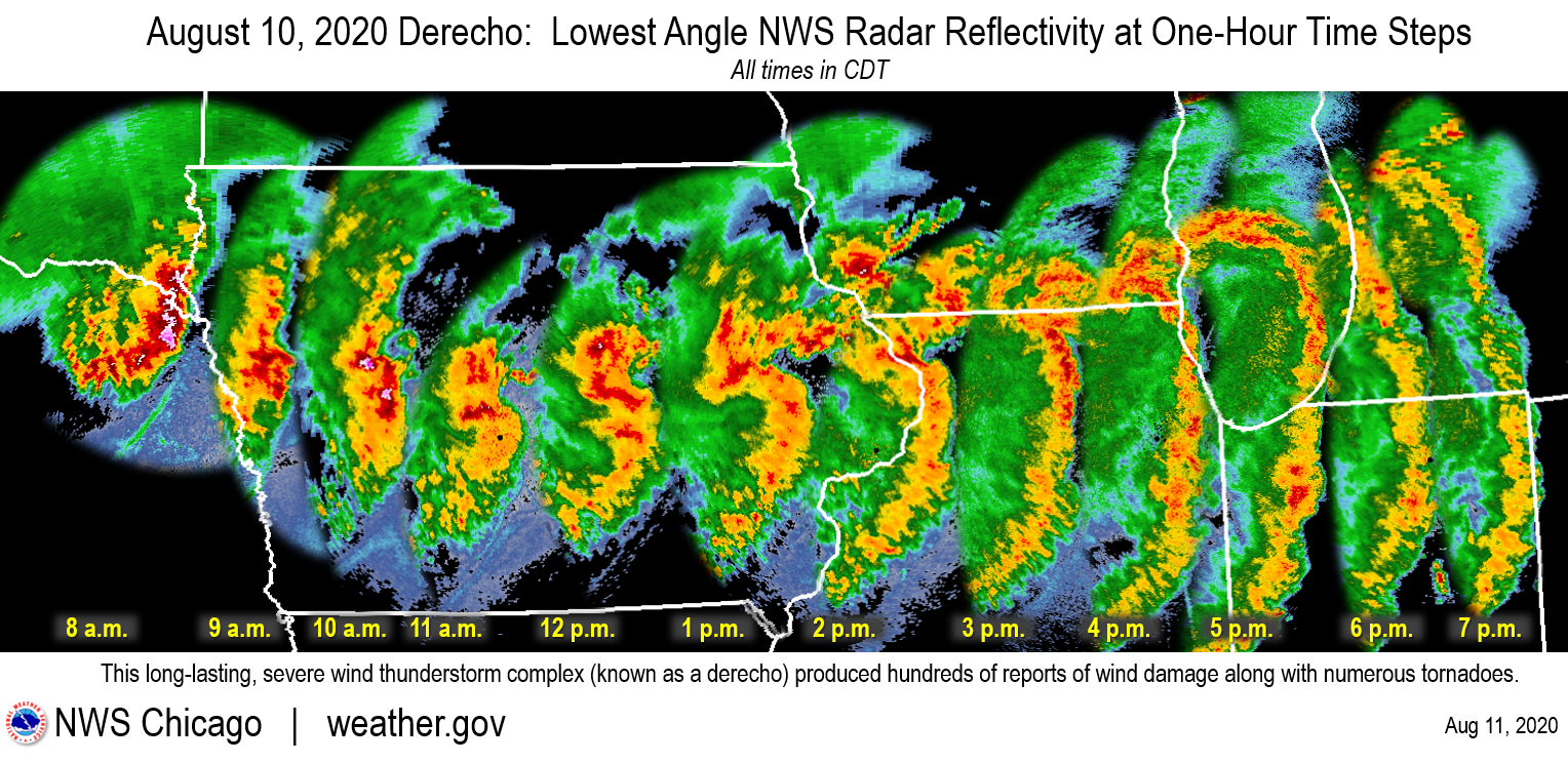
10th – 3.50″ of rain at JIA – daily record (1.92″, 1894)…. Midwest severe derecho centered on Iowa – most damaging t’storm complex in U.S. history
My 81 year-old dad helping cleanup in Tama, Iowa:

The leading edge (shelf cloud) of the derecho in hard-hit Cedar Rapids, Iowa:

Severely damaged school in Toledo, Iowa:

11th – 3.1″ of rain at Action News Jax… 3.7″ of rain at Nocatee
24th – T.S. “Marco” landfall mouth of the Mississippi southeast of New Orleans
27th – Cat. 4 “Laura” landfall at Cameron, LA

KPLC-TV studio in Lake Charles, Louisiana:

SEPTEMBER… +0.6 DEGREES / +1.06″
3rd – record Sept. heat index of 112 degrees (109, Sept. 5, 1983…. Cat. 1 “Nana” landfall – Belize
12th – T.D. #19 landfall at Miami… strengthens into T.S. “Sally” later in the day over the SE Gulf of Mexico
14th – Cat. 1 “Paulette” hits Bermuda
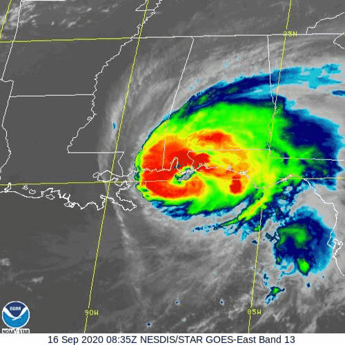
16th – EF-1 tornado hits Waycross, Ga…. Cat. 2 “Sally” landfall near Fl/Al border near Gulf Shores
Waycross tornado damage to a church:

Hurricane Sally making landfall:
19th – Strong “local” Nor’easter w/ 1-3″ of rain across St. Johns Co… flooding in St. Augustine… continues through the 21st


*** 10 tropical cyclones form during the month – most in any Sept. on record.
OCTOBER… +4.2 DEGREES / -0.44″
3rd – T.S. “Gamma” landfall in Mexico
6th – 1.49″ of rain at JIA but up to 4″ parts of Eastern St. Johns, Duval & Nassau Co.
7th – Cat. 2 “Delta” landfall near Cancun, Mexico
9th – Cat. 2 “Delta” landfall near Creole, LA.
13th – tie record high of 89 degrees (2017)
28th – Cat. 2 “Zeta” landfall close to New Orleans – Cocodrie, LA
29th – 90 degrees – record high (87/1984)
NOVEMBER…. +5.1 DEGREES / -0.10″
2nd – Hurricane “Eta” intensifies from a Cat. 1 at 4am to Cat. 4 by 4pm over the Western Caribbean
3rd – Cat. 4 “Eta” landfall near Peurto Cabezas, Nicaragua
8th – T.S. Eta landfall on the Central Cuban coast then the Fl. Keys in the evening
9th – 72 degrees – record high min. temp. tied (1911)
10th – 73 degrees – record high min. (71/2010)
11th – 76 degrees – record high min. (72/1883) + all-time record high min. for Nov. (74 – Nov. 21, 1985)
12th – 69 degrees – tie record high min. (1992)… T.S. “Eta” landfall at Cedar Key, FL… moves quickly over NW Duval Co. about 11am – no local damage.
15th – 85 degrees – tie daily record high (1958)
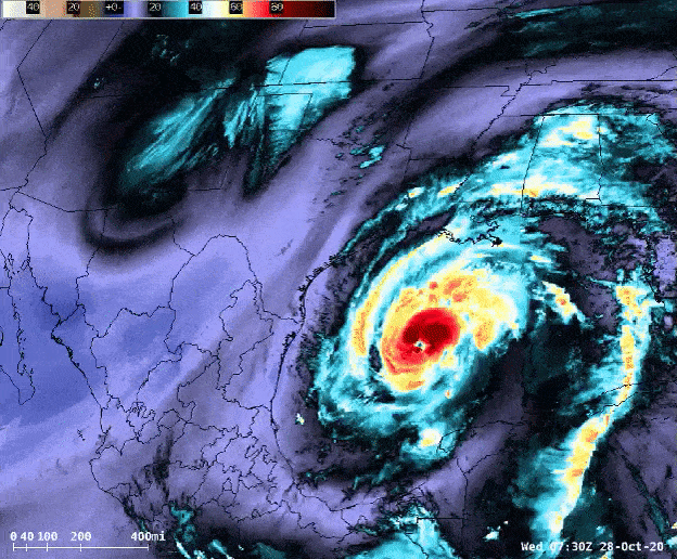
16th – Hurricane “Iota” strengthens into Cat. 5 over the W. Caribbean & goes on to hit the central coast of Nicaragua in the evening as a Cat. 4. Image below from NOAA:

DECEMBER… -2.5 DEGREES (FIRST below avg. Dec. since 2010!) / -0.46″
1st – Early morning low of 29 degrees – record for the 1st time below 30 degrees in 1,047 days (old record – 1,044 days from Jan. 16, 1998 to Nov. 25th, 1950)
14th – High of 81 degrees – 59th straight month with at least one 80 degree day (last month with no 80 degree days – Jan., 2016)
16th – EF-1 & EF-2 tornado in the Tampa area
17th – Central Pennsylvania to Central New York snowstorm – 30-45″!
21st – The “Great Conjunction” – planets Jupiter & Saturn “kiss” – closest in hundreds of years. Pic locally by Paul Norton:

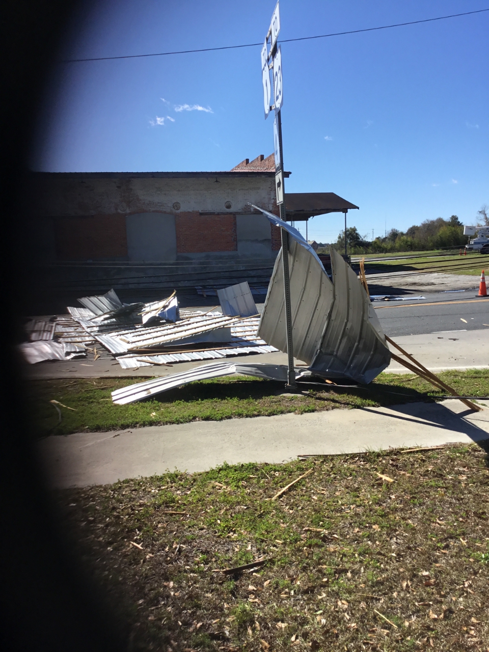
24th - Widespread damaging winds as squall line of t’storms races eastward across Jacksonville/NE Fl./SE Ga. Some of the most significant damage was near Starke, Fl where 2 injuries were reported caused by an EF-1 tornado as well as Baymeadows on the Southside of Jax - also an EF-1 with winds estimated near 105 mph:
:quality(70)/cloudfront-us-east-1.images.arcpublishing.com/cmg/U2POZFCYVBCCTAMHL36HPN7RCI.jpeg)

:quality(70)/cloudfront-us-east-1.images.arcpublishing.com/cmg/672SNDVYONEOVMWH6ELFJ2N3EE.jpeg)
Baymeadows tree down:
:quality(70)/cloudfront-us-east-1.images.arcpublishing.com/cmg/AAJWOKBIVJCC7DILO3LI674WBE.jpeg)
25th - 5th coldest Christmas day high temp. on record in Jacksonville - 48 degrees (coldest - 30 degrees, 1983)

Cox Media Group

:quality(70)/d1hfln2sfez66z.cloudfront.net/04-24-2024/t_d73855398dca4bf5a6e1eca4fedb0fdd_name_file_960x540_1200_v3_1_.jpg)
:quality(70)/cloudfront-us-east-1.images.arcpublishing.com/cmg/GUAD4ABRCRB4LJ6TP72IOU75WI.jpg)
:quality(70)/d1hfln2sfez66z.cloudfront.net/04-23-2024/t_8846f6a1613746e2863363cea1df0c34_name_file_960x540_1200_v3_1_.jpg)
:quality(70)/d1hfln2sfez66z.cloudfront.net/04-22-2024/t_ce7544ba150e4c27a8bfb667adb18b39_name_file_960x540_1200_v3_1_.jpg)
:quality(70)/cloudfront-us-east-1.images.arcpublishing.com/cmg/UPSNZVHYKZE2VDSCN54C3FTF5E.png)