:quality(70)/cloudfront-us-east-1.images.arcpublishing.com/cmg/4BY52YP3URHB3CBG6342FEUNGQ.jpg)
Jacksonville, FL — Still some late season “activity” to track in the tropics: “Talking the Tropics With Mike” updated every day during the hurricane season (through Nov. 30th).
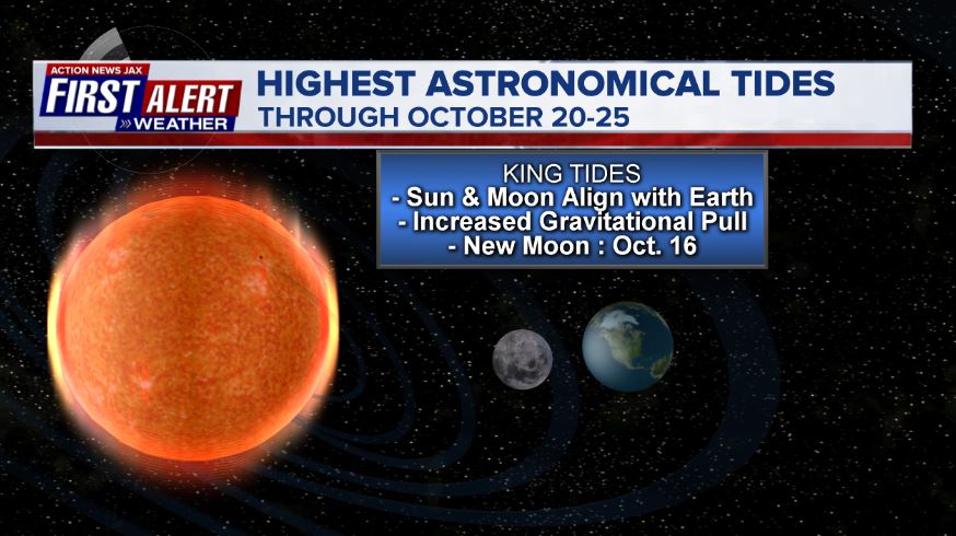
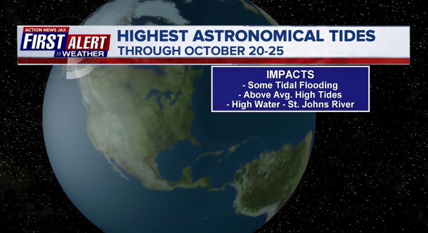
'Tis the season for king tides - an annual astronomical/marine phenomenon that occurs every mid to late autumn in Oct. & Nov. often resulting in some of the highest tides of the year. Throw in some meteorological input such as onshore (out of the east) winds &/or heavy rain & the tides can be especially high. King tides are the result of the new moon phase in conjunction with the sun & earth causing an increased gravitational pull. The result is at least some minor/nuisance flooding along the coast, intracoastal, St. Johns River & its tributaries along with beach erosion. The new moon in Nov. is on the 15th & will be the next round of king tides.
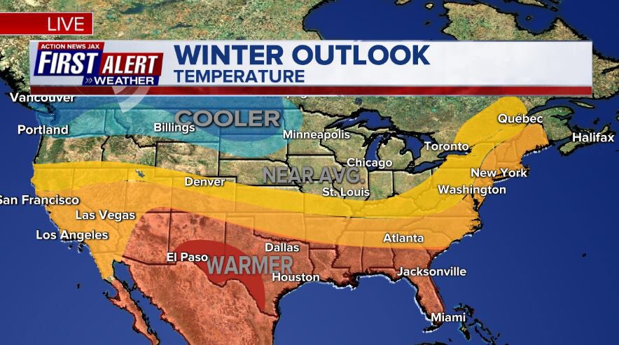
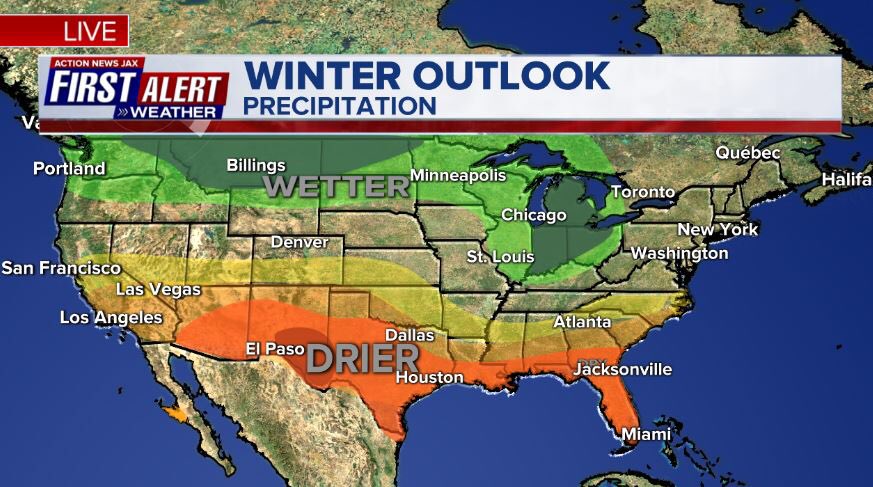
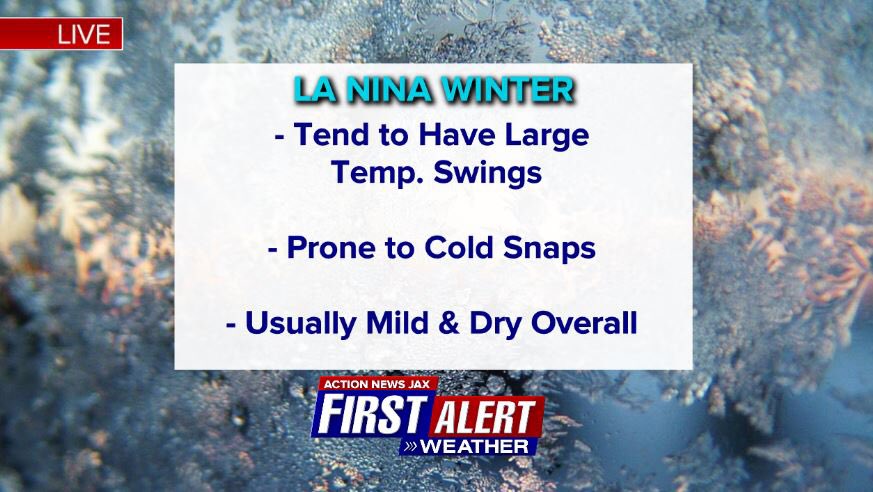
NOAA has issued their winter outlook. The forecast is largely predicated on the developing & maturing La Nina - cooling of the equatorial Pacific. In general... the pattern is expected to favor cooler than avg. temps. across the Northern Plains/Pacific NW to warmer than avg. across much of the south & eastern third of the U.S. Precip. tends to be above avg. in the Ohio Valley & Northern U.S. .... below avg. across the South. For Jacksonville/NE Fl./SE Ga.: the “call” is for above avg. temps. & below avg. precip. so dry & mild. Several points to ponder:
(1) The ENSO (El Nino Southern Oscillation) has been less “predictable” (reliable/consistent) - in my opinion - since the earth has warmed.
(2) A weak La Nina for Jacksonville & nearby areas has been - in the past - subject to big temp. swings favoring short but intense cold snaps. The current La Nina is forecast to be at least weak but possibly reaching moderate strength.
(3) A dry winter could lead to an enhanced wildfire season in the spring.
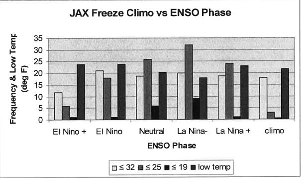
Jacksonville N.W.S. ENSO phase & freeze climatology. A weak La Nina has coincided with some of the most intense freezes on record (19 degrees F or lower) for Jacksonville. A strong La Nina - not so much.
From Brian Brettschneider - map indicates the trend toward milder temps. across much of the south for moderate-strong La Ninas with an average of 9-11 months above avg. during an at least 12 month La Nina episode:

NOAA sea surface temp. anomalies nicely shows the La Nina - cooler water - near the equator in the Pacific Basin:

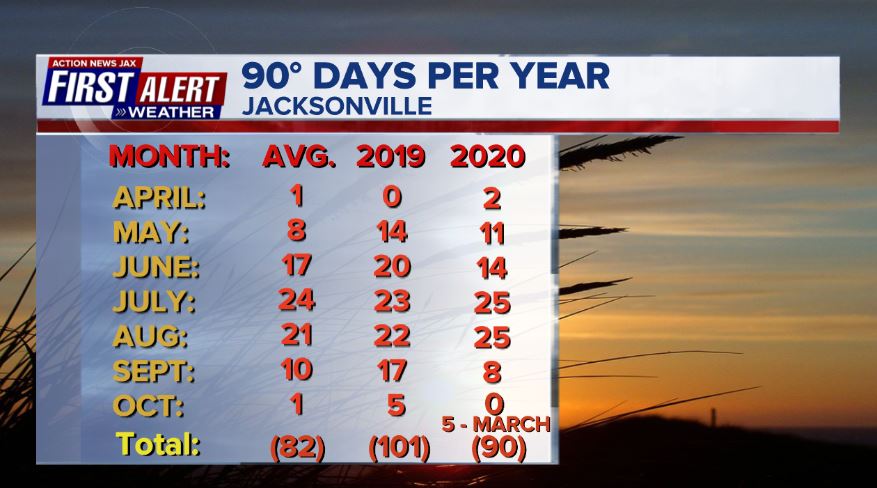
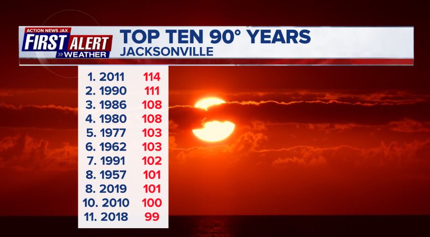
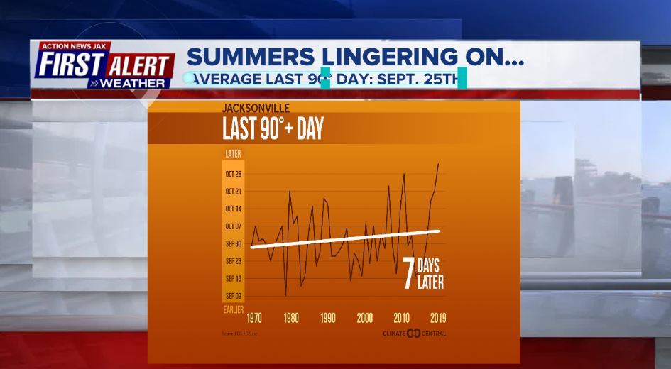
The winter ahead comes after a hot summer for much of the Lower 48 *but not so much* for Jacksonville & nearby areas (only slightly above avg. temps with a lower than avg. July). Having said that, our warming earth has led to a later date of the avg. last 90 temp. of the year for Jacksonville - between Sept. 26th & Oct. 5th vs. about a week earlier in the 1970s, ’80s & ’90s. So far - as of Oct. 15th - there have been no 90 degree days in Oct. with the total this year at 90 which is 8 days above avg. but far from the record of 110+ days (which has occurred twice [2011 & 1990] since 1871). Were it not for a hot start to spring with five 90-degree days in March, 2020 would be very near the annual avg. of 82 ninety- degree days. The latest 90 degree day on record, by the way - Oct. 31st, last year in 2019.
Cox Media Group

:quality(70)/d1hfln2sfez66z.cloudfront.net/04-22-2024/t_f5f241e0aad44a77a07c6df361d48410_name_file_960x540_1200_v3_1_.jpg)
:quality(70)/d1hfln2sfez66z.cloudfront.net/04-22-2024/t_ce7544ba150e4c27a8bfb667adb18b39_name_file_960x540_1200_v3_1_.jpg)
:quality(70)/d1hfln2sfez66z.cloudfront.net/04-23-2024/t_f0085089574c4cb191afcc848e53d848_name_file_960x540_1200_v3_1_.jpg)
:quality(70)/cloudfront-us-east-1.images.arcpublishing.com/cmg/WJVERMTCKFHFPBF2LNONHSDB4M.jpg)
:quality(70)/d1hfln2sfez66z.cloudfront.net/04-22-2024/t_2ed9b79169dc4769babdade6a9c7c303_name_file_960x540_1200_v3_1_.jpg)