:quality(70)/cloudfront-us-east-1.images.arcpublishing.com/cmg/WW5AJL3ARQUGDQMAQUNSFX4CLE.jpg)
Jacksonville, Fl. — The “Buresh Bottom Line”: Always be prepared!.....First Alert Hurricane Survival Guide... City of Jacksonville Preparedness Guide... Georgia Hurricane Guide.
STAY INFORMED: Get the * FREE * First Alert Weather app
FREE NEWS UPDATES, ALERTS: Action News Jax app for Apple | For Android
WATCH “Talking & Tracking the Tropics: The Science Behind the Season”
WATCH “Preparing for the Storm”
READ the First Alert Hurricane Center “Survival Guide”
***** ALWAYS CHECK & RE-CHECK THE LATEST FORECAST & UPDATES! *****
*** The first round of impacts from Eta occurred across South Florida last weekend. Round 2 hit the west coast of Fl. centered on Tampa Wed. followed by relatively minor impacts across North Fl. & SE Ga. into Thursday ***
FOR JACKSONVILLE/NE FL./SE GA:
** There has been no significant damage or any long term interruptions of our general infrastructure resulting from Eta.
** gusty winds - on the order of 10-20 mph with a few gusts 20-30 mph on the backside of Eta diminishing Thu. night.
** dangerous rip currents at area beaches with rough seas/surf will continue as winds turn offshore (from the west/northwest) through Thu. night into Friday. Seas & surf will slowly improve.
** The more significant rain is over. A few scattered showers will quickly move east/southeast as breaks in the clouds allow for some instability. Lingering showers will quickly dissipate Thu. evening.
Tropical depression #29 was upgraded Sat. afternoon, Oct. 31st & to tropical storm Eta Sat. evening then to a hurricane (12th of the Atlantic season) early Mon., Nov. 2nd - a high end Cat. 4 Mon. afternoon/evening followed by a Cat. 4 landfall on the northeast coast of Nicaragua Tue. afternoon. So Eta becomes the record-tying storm - 28th - for most in a single season. According to Dr. Klotzbach, Eta is also only the 5th Cat. 4 Nov. hurricane in the Atlantic Basin (Cuba Hurricane, 1932; Lenny, 1999; Michelle, 2001; Paloma, 2008). Conditions (shear, water temps., moisture) were all favorable for steady & rapid strengthening interrupted only by an eyewall replacement cycle Mon. night. The combination of the change in structure + proximity to land took Eta a bit off its peak while on a very slow journey inland. Eta re-emerged over the far Western Caribbean Thu. night... moving northeast across the Caribbean with a landfall on Central Cuba early Sunday, Nov. 8 as a strong tropical storm the the upper Fl. Keys Sunday night near 11pm EST. This is a record 12th U.S. landfall this year with at least one U.S. landfalling named storm in every month since May! Eta has been over the Gulf of Mexico since Sunday night moving north/northeast becoming a hurricane again Wed. morning - the latest Gulf hurricane since “Kate” in 1985. Eta weakened back to a tropical storm Wed. afternoon with gradual weakening right up to landfall at Key West about 4am EST. Impacts were minor after the 2nd Eta Fl. landfall & 4th overall (Nicaragua, Cuba, Keys, W. Fl. coast). Eta is the latest landfalling Florida tropical cyclone (depression/storm/hurricane) since “Gordon” in Nov., 1994 & is also the closest *Nov.* tropical system to Jacksonville since Gordon in ’94. The center moved across parts of Duval Co. matching the feat of Julia (Sept., 2016), Beryl (Memorial Day weekend, 2011) & Tammy (Oct., 2005) this century so far.
The ultimate outcome of Eta’s path came down to a high pressure ridge to the east of Fl. & an incoming mid latitude trough over the U.S.
MODELS:
The models significantly shifted east & increased the forward speed the last couple days & finally solved the enigma we know as “Eta”.
The GFS has been emphatic that Eta would make a comeback over the Caribbean then to near Fl. by last Sunday while peeling back to the west to the Gulf before turning north & northeast again & so has been reasonably good with Eta. The GFS has generally been faster & a little more north which is playing out. The model had been flip-flopping on whether or not the trough “catches” Eta but trended “catch” & taking a weakening Eta ashore on the northwest coast of Fl. then continuing northeast across N. Fl. then out to sea again east/northeast of Jacksonville while accelerating & becoming post-tropical while hooking up with a cold front.
The European model is pretty close to the GFS solution now though a bit slower & farther north.
The combination of increasing shear + land interaction not to mention cooler ocean water & some dry mid & upper level air has lead to weakening since the storm’s latest peak midday Wed.
So.... we should be able to get Eta out of the area & east of the entire U.S. by Thu. night while moving northeast over the Western Atlantic.
RECAP:
As a whole forecast models have been struggling with “all the low pressure” (there will again be some tropical development soon over the Caribbean) at low latitudes - the tropics & subtropics - not to mention the typical autumn-related fast-to-change meridional flow (troughs of low pressure & ridges of high pressure) over the higher latitudes. So we saw a lot of changes & fluctuations in the forecast models. Special (4 times a day) weather balloon launches across Fl. & much of the Southeast U.S. along with NOAA research aircraft sampling the atmosphere over & near Eta combined to seemingly add some stability to model forecast but not until late Tue./early Wed. Admittedly... Eta was a pain to forecast with many sharp turns & very poor model output though my initial call/thoughts of little damage from the latest landfall will turn out accurate.
Eta’s sinusoidal track has been tied to the upper level flow which has returned to what we’ve seen most of the hurricane season: a trough over/near the Central U.S. with increased ridging near Fl. & to the east. How this all evolved was critical in steering Eta. As the western portion of the ridge broke down enough & shifted east, Eta moved inland across North Florida & followed the alleyway between the ridge to the east & the trough to the west.


Courtesy S. Fl. Water Management District:


Moderate shear helped to weaken Eta upon approach to land in addition to cooler water temps.
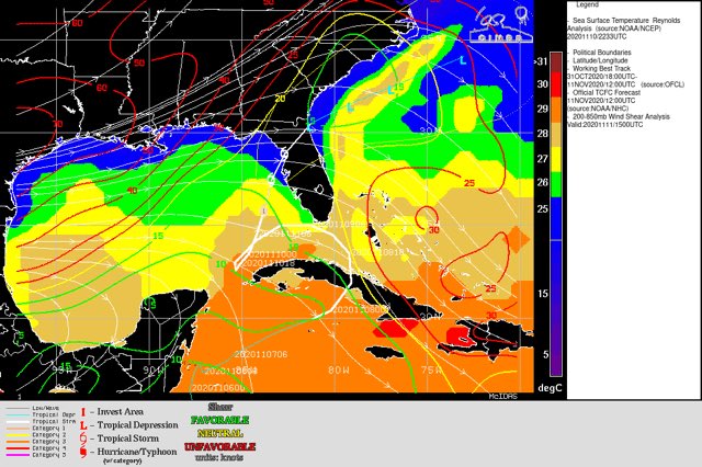


Very dry air is funneling south & east on the backside of Eta:

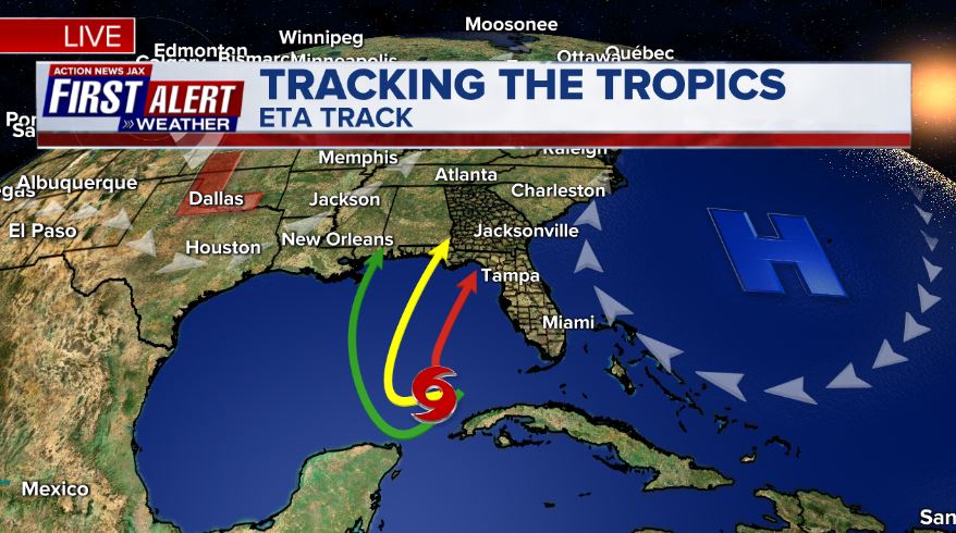
The steering “players”: After moving steadily west/southwest & even a little south, Eta turned around & is moved north/northeast. . As upper level high pressure to the east “softens” on its western edge while upper level troughing increases over the Central U.S., Eta made a sharper turn northeast. So Eta took the “red arrow” path. Complicated & interesting, maybe a little frustrating - to say the least - to forecast!

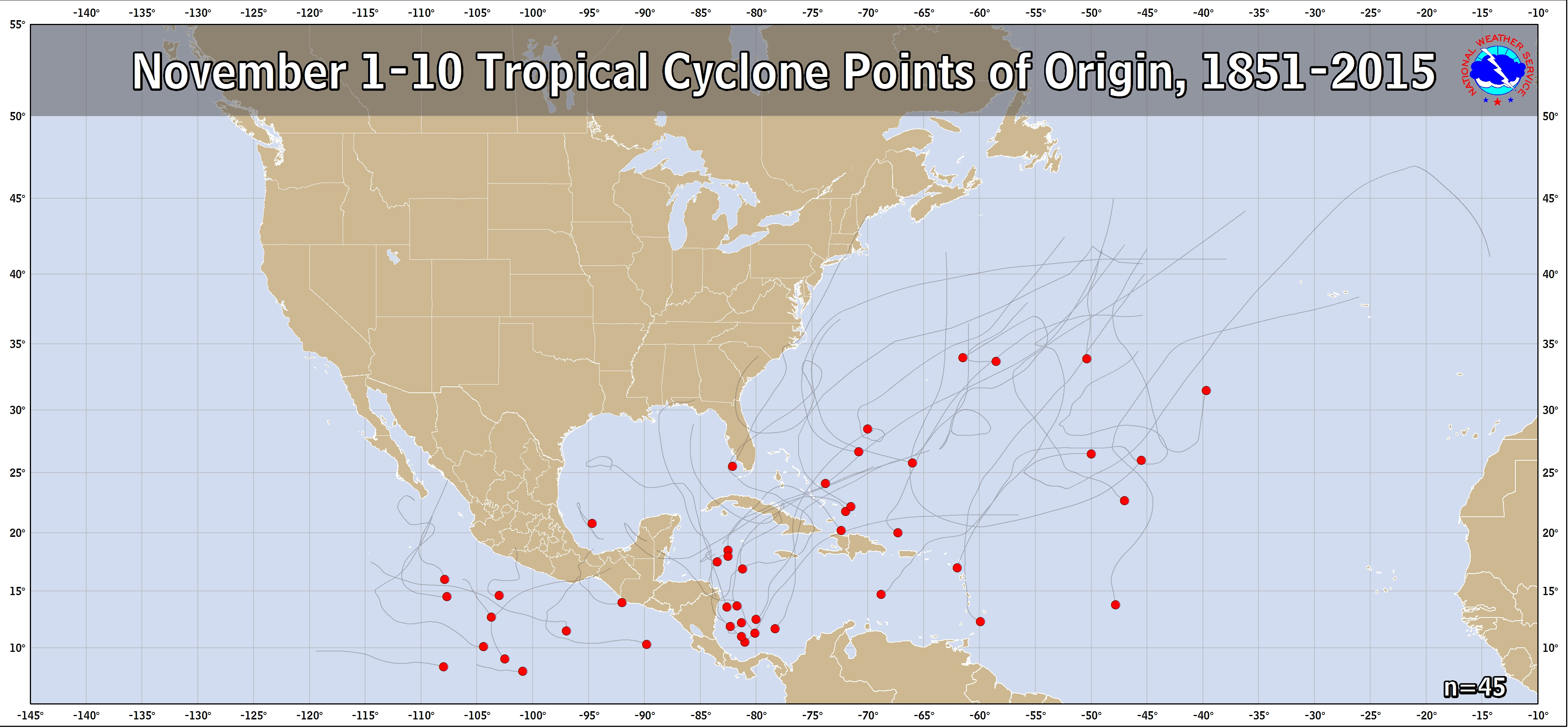
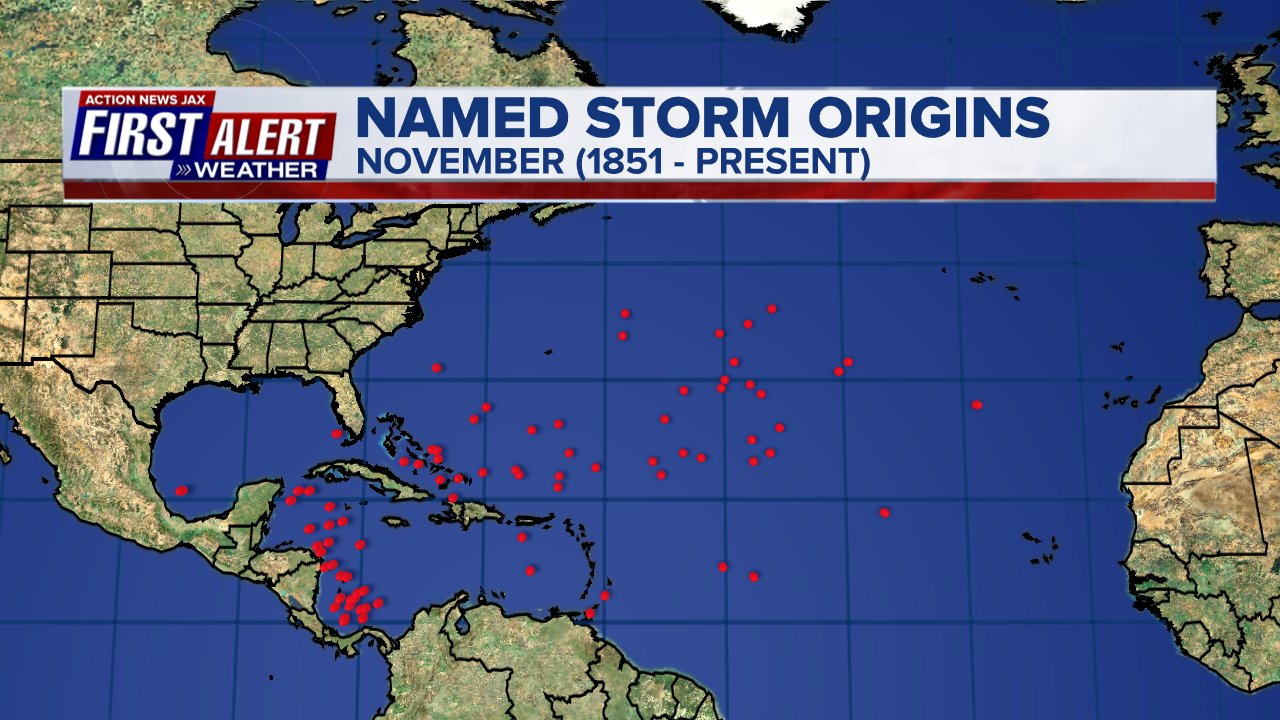
Eta technically developed on Oct. 31st but the map below will suffice & shows the Caribbean is a relative “hot bed” for late season/first 10 days of Nov. tropical cyclones:
And Theta formed over the East Atlantic - the record 29th storm of the season which beat the record of 28 in the infamous year of 2005. Theta will stay over the Eastern Atlantic & is no threat to the U.S. or any land areas & should become extra-tropical by the weekend.

Elsewhere... Another tropical wave, 98-L - over the Caribbean - has longer range potential for gradual development. It appears this system will stay over/near the Caribbean (vs. turning north) as the disturbance moves toward the west & bends a little southwest potentially becoming a hurricane(!) before moving into Central America by the middle of next week.

More spaghetti:

Atlantic Basin wave forecast for 24, 48 & 72 hours respectively:


:quality(70)/cloudfront-us-east-1.images.arcpublishing.com/cmg/LW2VP2Y6PJDZPLDJCDBZRFVCAI.png)
:quality(70)/cloudfront-us-east-1.images.arcpublishing.com/cmg/NZS3DHFYIBFCNMPEVK5ZZLQ6XE.jpg)
:quality(70)/cloudfront-us-east-1.images.arcpublishing.com/cmg/NQCTWRA7OVFP5ABEQBTBAG2E3A.jpg)
:quality(70)/cloudfront-us-east-1.images.arcpublishing.com/cmg/N7YMXJTJYJEFBCXSUI6KPLO7OM.png)
:quality(70)/d1hfln2sfez66z.cloudfront.net/04-19-2024/t_fc72695bddad400cbcdf60101dc0389b_name_file_960x540_1200_v3_1_.jpg)