Jacksonville, Fl. — The “Buresh Bottom Line”: Always be prepared!.....First Alert Hurricane Survival Guide... City of Jacksonville Preparedness Guide... Georgia Hurricane Guide.
STAY INFORMED: Get the * FREE * First Alert Weather app
FREE NEWS UPDATES, ALERTS: Action News Jax app for Apple | For Android
WATCH “The Ins & Outs of Hurricane Season”
WATCH “Preparing for the Storm”
READ the First Alert Hurricane Center “Survival Guide”
***** ALWAYS CHECK & RE-CHECK THE LATEST FORECAST & UPDATES! *****
Weak tropical storm “Danny” made landfall about 7:30pm EDT Mon. just north of Hilton Head, SC. Rainfall in & around Savannah reached as much as 3-5″ causing localized flooding but no sustained winds at tropical storm force (39+ mph) were measured over land or even at the coast. No serious damage resulted from Danny, & the last advisory was issued early Tue. morning.
Meanwhile... a tropical wave is moving over the Central Atlantic & continues to march west/northwest with a second tropical wave over the Eastern Atlantic. The first wave will be into the Caribbean Wed. night - Thu. producing some gusty squalls. Conditions are not perfect - quite a bit of dry mid & upper level air along with moderate to strong shear at the moment - so a great deal of intensification seems unlikely.
The trailing wave over the Eastern Atlantic is at a low latitude nearing 40 degrees W, just 8 degrees N. This wave should gain some latitude (a little more north) while moving W/NW this week. Early indications are that conditions may be more favorable for development by the weekend, & everyone in the Caribbean should keep an eye on this wave. It appears the Bermuda High will remain strong - possibly even expanding some - through the weekend. This set-up could continue to push the wave W/NW through the weekend followed by *possibly* more of a turn to the north. Any turn north will ultimately depend on the strength & positioning of the Bermuda High east of Florida.
There is also quite a bit of storminess over the Western Gulf of Mexico. We’ll need to watch this area for possible surface low development though nothing is indicated at the moment.


‘Invest 95-L’:

‘Invest 97-L’:


Saharan dust. Dry air - yellow/orange/red/pink - is extensive over the Central & Eastern Atlantic. Such widespread dust is common early in the hurricane season:

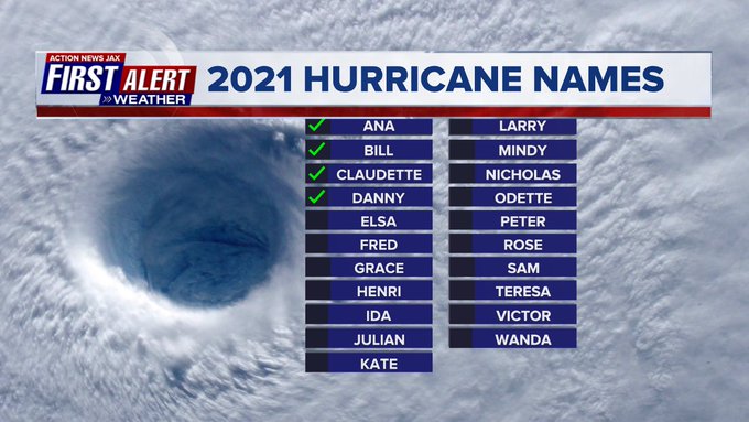
2021 names..... “Elsa” is the next name on the Atlantic list (names are picked at random by the World Meteorological Organization... repeat every 6 years... historic storms are retired (Florence & Michael in ’18... Dorian in ’19 & Laura, Eta & Iota in ‘20). Last year - 2020 - had a record 30 named storms. The WMO decided beginning in 2021 that the Greek alphabet will be no longer used & instead there will be a supplemental list of names if the first list is exhausted (has only happened twice - 2005 & 2020). More on the history of naming tropical cyclones * here *.

East Atlantic:


Mid & upper level wind shear (enemy of tropical cyclones) analysis (CIMMS). The red lines indicate strong shear which is widespread from the Gulf of Mexico & Caribbean eastward across much of the Atlantic:
Water vapor imagery (dark blue indicates dry air):

Deep oceanic heat content is slowly increasing across the SE Gulf, Caribbean & deep tropical Atlantic:

Sea surface temp. anomalies:


SE U.S. surface map:

Surface analysis centered on the tropical Atlantic:

Surface analysis of the Gulf:

Caribbean:

Atlantic Basin wave forecast for 24, 48 & 72 hours respectively:


“Enrique” became a hurricane Saturday off the west coast of Mexico over the far Eastern Pacific but is now weakening. Enrique is turning more northwest, so conditions will continue to improve along the west coast of Mexico. A weakening tropical depression will then move over the east coast of the Baja Peninsula Wed.-Wed. night with some heavy rain & gusty winds.


Global tropical activity:

Cox Media Group
:quality(70)/cloudfront-us-east-1.images.arcpublishing.com/cmg/WW5AJL3ARQUGDQMAQUNSFX4CLE.jpg)

:quality(70)/d1hfln2sfez66z.cloudfront.net/04-17-2024/t_6061b3560fca4ac9aa6b873a534bfe28_name_file_960x540_1200_v3_1_.jpg)
:quality(70)/d1hfln2sfez66z.cloudfront.net/04-18-2024/t_a469d507a8ea40cbbe96c13d032a8df4_name_file_960x540_1200_v3_1_.jpg)
:quality(70)/cloudfront-us-east-1.images.arcpublishing.com/cmg/NQCTWRA7OVFP5ABEQBTBAG2E3A.jpg)
:quality(70)/cloudfront-us-east-1.images.arcpublishing.com/cmg/2Y6P7UIUZZGYBDCHMSOQKT3P4M.jpg)
:quality(70)/cloudfront-us-east-1.images.arcpublishing.com/cmg/DZPQF7RH4NDGZBUGLSPVDN43XU.jpg)