:quality(70)/cloudfront-us-east-1.images.arcpublishing.com/cmg/WW5AJL3ARQUGDQMAQUNSFX4CLE.jpg)
Jacksonville, Fl. — The “Buresh Bottom Line”: Always be prepared!.....First Alert Hurricane Survival Guide... City of Jacksonville Preparedness Guide... Georgia Hurricane Guide.
STAY INFORMED: Get the * FREE * First Alert Weather app
FREE NEWS UPDATES, ALERTS: Action News Jax app for Apple | For Android
WATCH “Talking & Tracking the Tropics: The Science Behind the Season”
WATCH “Preparing for the Storm”
READ the First Alert Hurricane Center “Survival Guide”
***** ALWAYS CHECK & RE-CHECK THE LATEST FORECAST & UPDATES! *****
There are no areas of immediate concern over the Atlantic basin as we kick off the 2021 hurricane season.
There are some indications of possible mid June development over or near the Caribbean &/or Gulf of Mexico though nothing is imminent.
The next name on the list is “Bill”. “Ana” was a brief tropical storm over the Central & North Atlantic in mid May.
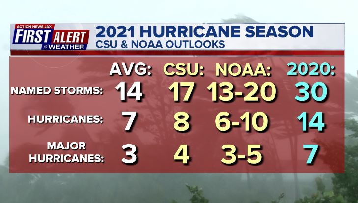
Forecasts are for an active season. Averages have been adjusted based on the 30-year period from 1991-2020.


Saharan dust. Dry air - yellow/orange/red/pink - is extensive over especially the Central & Eastern Atlantic. Such widespread dust is quite common early in the hurricane season:

2021 names..... “Bill” is the next name on the Atlantic list (names are picked at random by the World Meteorological Organization... repeat every 6 years... historic storms are retired (Florence & Michael in ’18... Dorian in ’19 & Laura, Eta & Iota in ‘20). Last year - 2020 - had a record 30 named storms. The WMO decided beginning in 2021 that the Greek alphabet will be no longer used & instead there will be a supplemental list of names if the first list is exhausted (has only happened twice - 2005 & 2020). More on the history of naming tropical cyclones * here *.


East Atlantic:


Mid & upper level wind shear (enemy of tropical cyclones) analysis (CIMMS). The red lines indicate strong shear which is widespread from the Gulf of Mexico & Caribbean eastward across much of the Atlantic:

Water vapor imagery (dark blue indicates dry air):

Deep oceanic heat content is lacking but typical for so early in the season:

Sea surface temp. anomalies:


SE U.S. surface map:

Surface analysis centered on the tropical Atlantic:

Surface analysis of the Gulf:

Caribbean:

Atlantic Basin wave forecast for 24, 48 & 72 hours respectively:


Global tropical activity:


Cox Media Group
:quality(70)/cloudfront-us-east-1.images.arcpublishing.com/cmg/JPGZ66AVOREFDNYQVMU4ULSFFM.jpg)
:quality(70)/cloudfront-us-east-1.images.arcpublishing.com/cmg/AR5LIUH3ZGV63HJ6N5NKIUDDUI.jpg)
:quality(70)/cloudfront-us-east-1.images.arcpublishing.com/cmg/A5WDDJVOEVBH7AVABNPTTA6C3Y.jpg)
:quality(70)/cloudfront-us-east-1.images.arcpublishing.com/cmg/5DQX77Y4KRDTPJFHATNPCPNWNQ.jpg)
:quality(70)/d1hfln2sfez66z.cloudfront.net/04-15-2024/t_bde394ea388d434ca0b114db015c7127_name_file_960x540_1200_v3_1_.jpg)