:quality(70)/cloudfront-us-east-1.images.arcpublishing.com/cmg/WW5AJL3ARQUGDQMAQUNSFX4CLE.jpg)
Jacksonville, Fl. — The “Buresh Bottom Line”: Always be prepared!.....First Alert Hurricane Survival Guide... City of Jacksonville Preparedness Guide... Georgia Hurricane Guide.
STAY INFORMED: Get the * FREE * First Alert Weather app
FREE NEWS UPDATES, ALERTS: Action News Jax app for Apple | For Android
WATCH “Talking & Tracking the Tropics: The Science Behind the Season”
WATCH “Preparing for the Storm”
READ the First Alert Hurricane Center “Survival Guide”
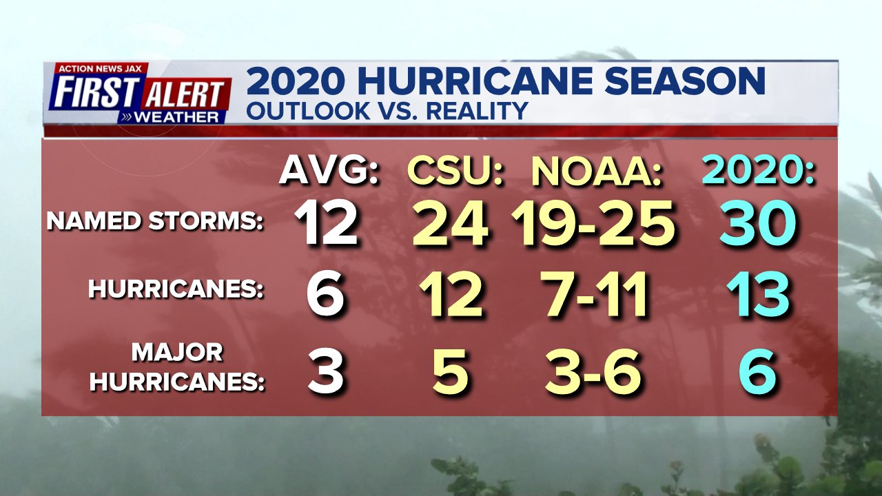
2020 will go down in the record books: most named storms in a single season - 30 (old record: 28/2005)...
* 13 hurricanes - the 2nd most on record...
* 6 “major” (Cat. 3+) hurricanes tied for 2nd most...
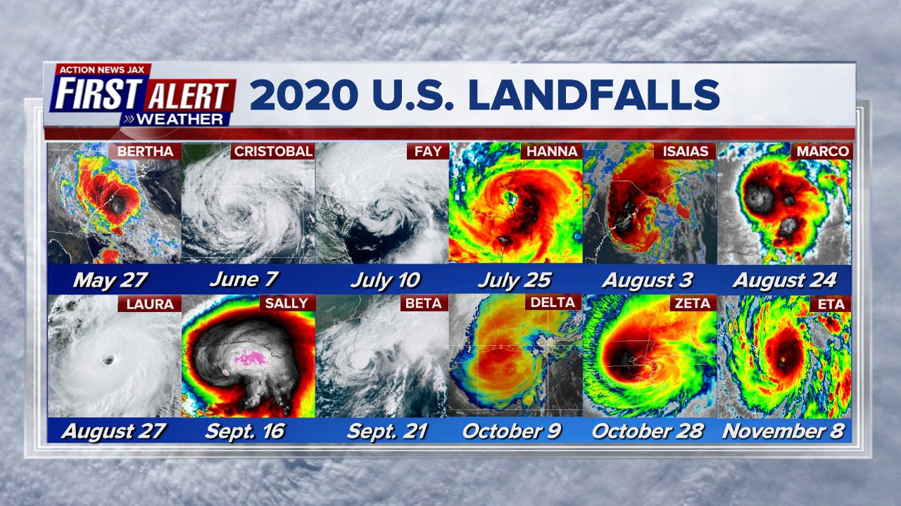
* most storms to ever make U.S. landfall: 12 (old record - 9 in 1916)...
* tie (with 1985 & 1886) for the most U.S. hurricane hits in a season: 6...
* 2020 made it a record 5 straight years with an above avg. number of names storms beating the record of 4 years straight from 1998-2001...
* a number of storms intensified - some rapidly - upon approach to land with Hanna, Isaias, Laura, Nana, Paulette, Sally, Eta & Iota increasing by at least 15 mph while approaching land - Laura, Eta & Iota underwent especially rapid intensification - Laura & Eta to Cat. 4 in little more than 24 hours & Iota to a Cat. 5...
* & many storm names were the fastest to get to their respective letter (only Arthur, Bertha & Dolly were not)
* Iota marked the 5th straight year (7 Cat. 5′s in all) with at least one Cat. 5 over the Atlantic Basin - a feat never matched previously. Remarkably - there was at least one U.S. landfall each month from May through Nov.
Seasonal forecasts were “bullish” but still underdone:
:quality(70)/cloudfront-us-east-1.images.arcpublishing.com/cmg/PRKRJE2CNZDNPHXUFM4QNDEEAU.jpeg)
:quality(70)/cloudfront-us-east-1.images.arcpublishing.com/cmg/TTUE3WMJF5H7DKTU4YBNSHKLIU.jpeg)
:quality(70)/cloudfront-us-east-1.images.arcpublishing.com/cmg/AQTUBU54VVFDJGQRQX3T3BAPDU.jpeg)
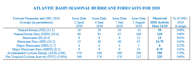
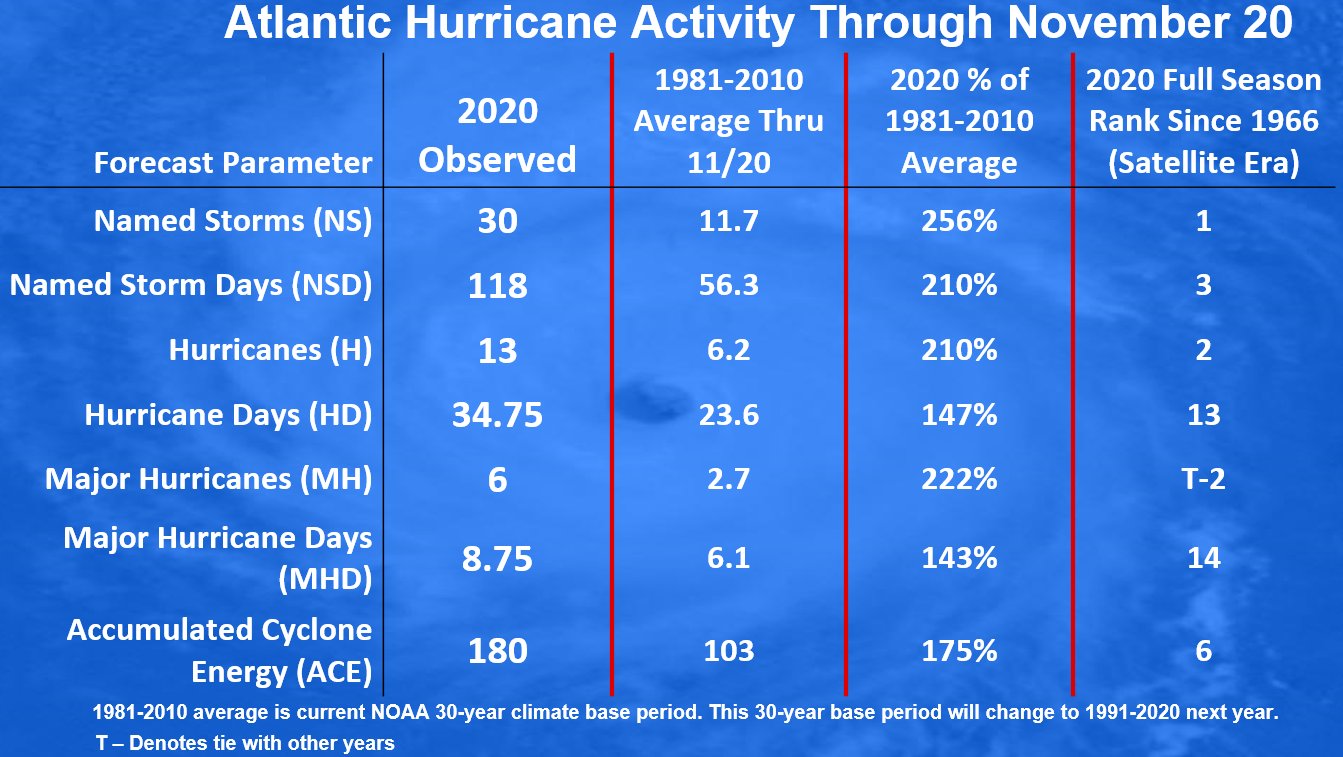
The two tables below are from Dr. Phil Klotzbach, Colorado State University:
Another remarkable stat/map: the entire U.S. coastline from Texas to Florida to Maine was under a tropical storm/hurricane &/or storm surge watch or warning in 2020!......
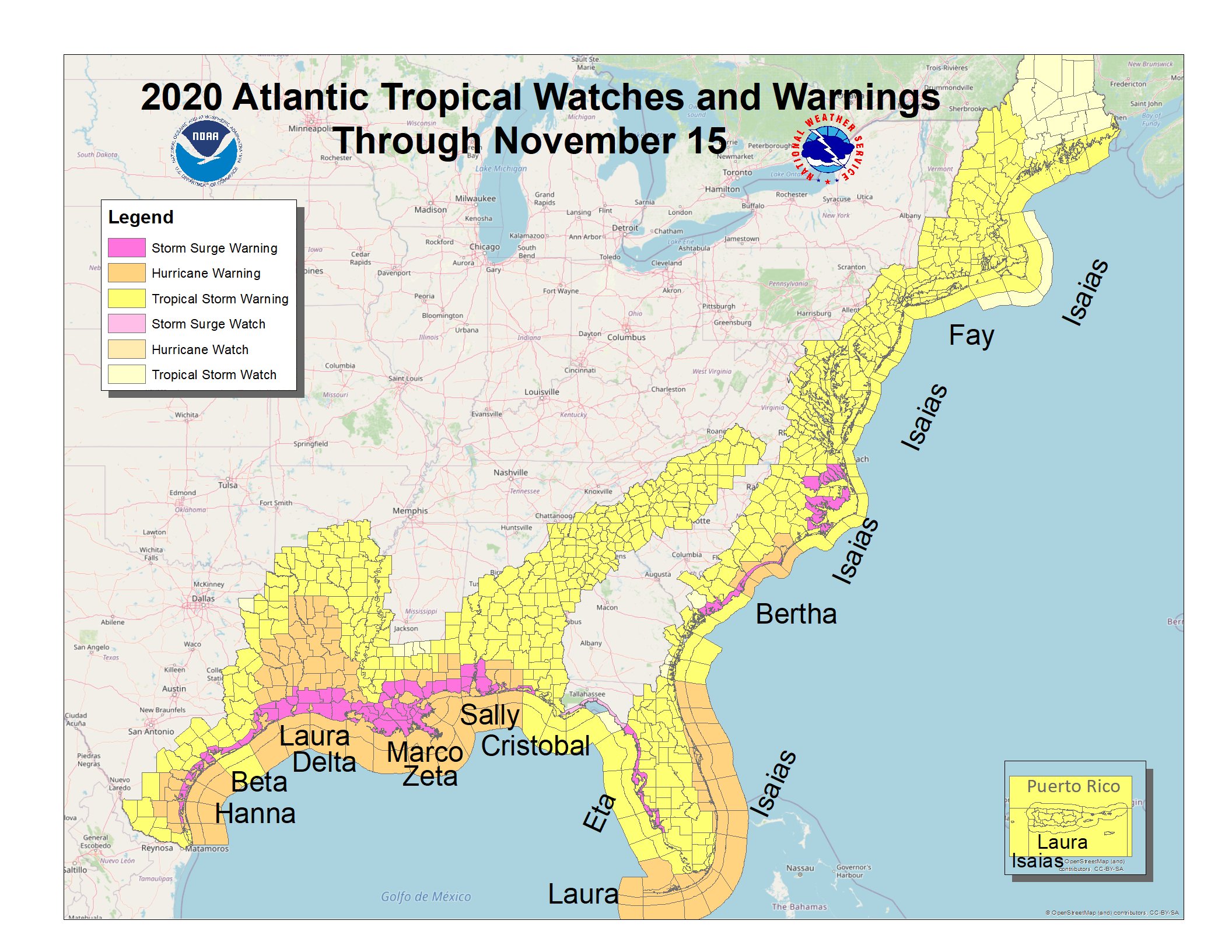
One “major” (Cat. 3+) hurricane landfall along the U.S. coastline was added to the map in 2020 - Cat. 4 Laura near Cameron, Louisiana:
MAY
16th: An early start to the season as tropical storm “Arthur” formed east of Jacksonville with the last advisory issued on the 19th over the W. Atlantic
27th: A quick to develop “Bertha” became a tropical storm upon approach to Charleston, SC & moved inland with the last advisory issued the same day.
JUNE
1st: T.D. #3 formed over the Bay of Campeche (SW Gulf of Mexico) & became tropical storm “Cristobal” on the 2nd with a Mexico landfall on the 3rd.... the storm weakened then turned north with a landfall on the 7th just east of New Orleans as a weak tropical storm with the last advisory on the 8th.
22nd: Subtropical depression forms east of Chesapeake Bay & briefly becomes “Dolly” on the 23rd with the last advisory on the 24th.
JULY
4th: T.D. #5 forms SW of Bermuda & becomes “Edouard” on the 5th with last advisory on the 6th
9th: Tropical storm “Fay” develops off the N. Carolina coast & moves north with a landfall on the 10th near Atlantic City, NJ ... the last advisory on the 11th.
21st: T.D. # 7 forms over the Central Atlantic & becomes tropical storm “Gonzalo” on the 22nd... last advisory on the 25th
22nd: T.D. #8 forms & becomes tropical storm “Hanna” on the 23rd over the Gulf of Mexico... makes a Cat. 1 hurricane landfall on the coast of Texas near Corpus Christi on the 25th - pics * here *... last advisory on the 26th.
29th: Tropical storm “Isaias” develops over the NE Caribbean & becomes a hurricane on the 30th north of the Dominican Republic.
31st: T.D. #10 forms over the E. Atlantic
AUGUST
1st: T.D. #10 dissipates... Cat. 1 “Isaias” landfall on Aboco Island, Bahamas... moves east of Jacksonville by 100+ miles on the 2nd... Cat. 1 landfall at 11:15pm EDT at Ocean Beach, NC. - pics * here * - with last advisory on the 5th
13th: T.D. #11 develops over the Central Atlantic & becomes tropical storm “Josephine”.
14th: Tropical storm “Kyle” forms over the NW Atlantic
16th: last “Josephine” & “Kyle” advisories
19th: T.D. #13 forms over the Central Atlantic
20th: T.D. #14 forms over the W. Caribbean & becomes tropical storm “Marco” in the evening
21st: T.D. #13 strengthens into tropical storm “Laura” east of the Leeward Islands
23rd: “Marco” goes hurricane then back to a tropical storm with landfall near the mouth of the Mississippi on the 24th... last advisory on the 25th
27th: Cat. 4 “Laura” landfall at Cameron, Louisiana at 1:50am EDT... last advisory on the 28th. Gulf coast damage pics via the “Washington Post” * here *.
31st: T.D. #15 forms over the W. Atlantic
SEPTEMBER (most named storms to ever develop in a single month - 10!)
1st: Tropical storm “Nana” forms over the Central Caribbean... tropical storm “Omar” over the W. Atlantic... Nana makes landfall as a t.s. on the coast of Belize on the 3rd... last Omar advisory over the Atlantic on the 5th
6th: T.D. #17 forms over the E. Atlantic & becomes “Paulette” on the 7th
7th: T.D. #18 over the E. Atlantic & becomes t.s. “Rene”
11th: T.D. #19 develops just off the SE Fl. coast with a landfall near Miami @ 2am on the 12th
12th: T.D. #19 strengthens into t.s. “Sally” SE Gulf of Mexico... t.d. #20 forms over the E. Atlantic.. “Paulette” goes hurricane Central Atlantic
14th: T.D. #21 forms over the E. Atlantic & becomes “Vicky”... Cat. 1 “Paulette” hits Bermuda... “Sally” goes hurricane over the Northern Gulf... t.d. #20 forms over the Central Atlantic & becomes “Teddy”... last “Rene” advisory
16th: Cat. 2 “Sally” landfall at Gulf Shores, Alabama - aftermath pics * here *... last “Paulette” advisory
17th: Last “Sally” & “Vicky” advisories
18th: t.d. #22 forms over the Gulf & becomes “Beta”... tropical storm “Wilfred” E. Atlantic... t.s. “Alpha” briefly forms over NE Atlantic & makes landfall on the coast of Portugal
21st: “Paulette” becomes a tropical storm *again* over E. Atlantic... t.s. “Beta” landfall at Victoria, Texas... last “Wilfred” advisory
22nd: Last advisories on “Beta”, “Paulette” & “Teddy”
OCTOBER
2nd: t.d. #25 W. Caribbean & becomes t.s. “Gamma” with a landfall on the Yucatan Peninsula on the 3rd... last advisory on the 5th
4th: t.d. #26 Central Caribbean... becomes t.s. “Delta” on the 5th & becomes a hurricane
7th: Cat. 2 “Delta” landfall near Cancun
9th: Cat. 2 “Delta” landfall east of Cameron, Louisiana... last advisory on the 10th
19th: T.D. #27 forms & becomes t.s. “Epsilon” over the Central Atlantic
24th: T.D. #28 forms over the NW Caribbean & becomes t.s. “Zeta” on the 25th... last “Epsilon” advisory on the 25th
28th: Cat. 2 “Zeta” landfall southeast of New Orleans - pics * here *... last advisory on the 29th
31st: T.D. #29 forms over the Central Caribbean & becomes t.s. “Eta”
NOVEMBER
3rd: Cat. 4 “Eta” landfall on the northeast coast of Nicaragua - pics * here *
8th: T.S. “Eta” landfall on the central Cuba coast early in the morning.... in the Fl. Keys in the evening
12th: T.S. “Eta” landfall at Cedar Key, Fl. near 4am EST... moves over Duval Co. as a very weak tropical storm near 11am EST... last advisory on the 13th. Tampa pic’s * here *.
While not producing any damage in Jacksonville/NE Fl./SE Ga., tropical storm Eta was one of just a handful of named storms that have moved directly over Duval Co. within the last 20 years:

13th: T.D. #31 forms over the Caribbean & strengthens into t.s. “Iota”
16th: “Iota” goes Cat. 5 over the W. Caribbean & hits Nicaragua as Cat. 4 in the evening - pics * here *
18th: Last “Iota” advisory over Central America
ATLANTIC BASIN:
***** ALWAYS CHECK & RE-CHECK THE LATEST FORECAST & UPDATES! *****
Atlantic Basin wave forecast for 24, 48 & 72 hours respectively:


:quality(70)/cloudfront-us-east-1.images.arcpublishing.com/cmg/UPSNZVHYKZE2VDSCN54C3FTF5E.png)
:quality(70)/cloudfront-us-east-1.images.arcpublishing.com/cmg/5BGF6ZRBF5BH3JEEOYZ2JOLJAA.png)
:quality(70)/d1hfln2sfez66z.cloudfront.net/04-24-2024/t_d73855398dca4bf5a6e1eca4fedb0fdd_name_file_960x540_1200_v3_1_.jpg)
:quality(70)/d1hfln2sfez66z.cloudfront.net/04-23-2024/t_8846f6a1613746e2863363cea1df0c34_name_file_960x540_1200_v3_1_.jpg)
:quality(70)/d1hfln2sfez66z.cloudfront.net/09-04-2020/t_ce46dce8467b4184a3d9ab75ef6b4cbc_name_THUMB.jpg)