:quality(70)/cloudfront-us-east-1.images.arcpublishing.com/cmg/WW5AJL3ARQUGDQMAQUNSFX4CLE.jpg)
Jacksonville, Fl. — The “Buresh Bottom Line”: Always be prepared!.....First Alert Hurricane Survival Guide... City of Jacksonville Preparedness Guide... Georgia Hurricane Guide.
STAY INFORMED: Get the * FREE * First Alert Weather app
FREE NEWS UPDATES, ALERTS: Action News Jax app for Apple | For Android
WATCH “The Ins & Outs of Hurricane Season”
WATCH “Preparing for the Storm”
READ the First Alert Hurricane Center “Survival Guide”
***** ALWAYS CHECK & RE-CHECK THE LATEST FORECAST & UPDATES! *****
REMEMBER WHEN A TROPICAL STORM OR HURRICANE IS APPROACHING: Taping windows is *NOT* helpful & will not keep glass from breaking... & realize the cone is the average forecast error over a given time - out to 5 days - & *does not* indicate the width of the storm &/or damage therefore do not become fixated on the center of a tropical system.

Ida:
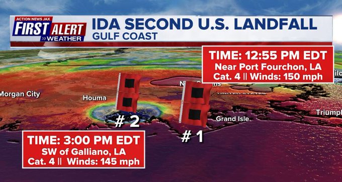
Landfall: NOAA Doppler radar imagery indicates that the eye of Ida made landfall along the southeastern coast of Louisiana near Port Fourchon - about 100 miles south of New Orleans - around 1155 AM CDT (1655 UTC)/12:55pm EDT. Data from an Air Force Reserve reconnaissance aircraft and Doppler radar data indicate that Ida’s maximum sustained winds at landfall were estimated to be 150 mph (240 km/h). The minimum central pressure estimated from reconnaissance aircraft data was 930 mb (27.46 in). A second landfall - with winds still near 145 mph/Cat. 4 - occurred near 3:00pm EDT just SW of Galliano, La.
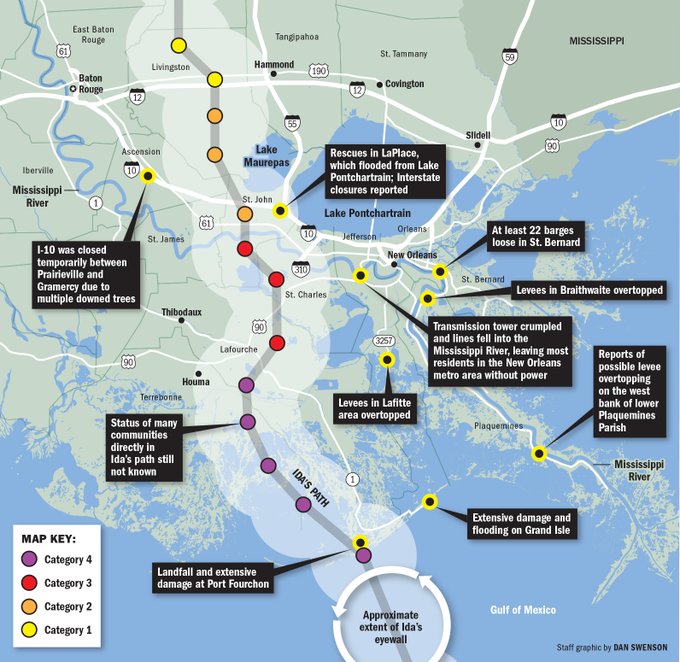
As feared since last Wed. (”TTTWM, Aug. 25 *here*), Ida will be a major/historical hurricane hit on the Central Gulf Coast with particular focus on Louisiana/Mississippi. The approach from the southeast nearly 100 miles south of New Orleans spared the Crescent City the highest winds but there were still major impacts on the city including A LOT of water - both fresh (rain) & salt (surge) + a 100% power outage.
Ida continues the string of “bad luck” for Louisiana after 3 hurricanes & 1 tropical storm landfall last year in addition to tropical storm Claudette this year.
Ida’s last historic weather story was finally completed through early Thu. with widespread severe/historic flooding along with tornadoes from N. Carolina to New England. The low pressure area is accelerating to the northeast & moving away from the U.S.
‘I’ is rather notorious over the years & is the most retired letter of the Atlantic seasonal alphabet. Since 1955, there have been 11 ‘I’ names retired including Iris, Isidore, Isabel & Ivan in consecutive years from 2001-’04. Most recently Irma was retired in 2017 & Iota in 2020. Tied for second in retired letters is ‘C’ & ‘F’ with nine each.


Meanwhile... tropical depression #12 became T.S “Larry” Wed. then a hurricane early Thu. & will soon intensify into a “major” Cat. 3+. *BUT* it continues to like Larry will stay far to the east over the open Atlantic through its lifetime thanks to a displaced - to the northeast - Bermuda High. Larry could get uncomfortably close to Bermuda about the middle of next week. And despite the hurricane’s considerable distance from any mainland, Larry will be large enoug/strong enough to push an easterly swell to the Caribbean & east coast of the U.S. enhancing the rip current risk late in the holiday weekend into next week. The eye of the hurricane will reach Jacksonville’s latitude - about 30 degrees N - by the middle of next week but hundreds of miles to the east.
There should be cycling of the hurricane once mature with some fluctuations in intensity due to eyewall replacement cycles. It’ll be interesting to see if Larry tries to go annular next week.
In any case, Larry is the 5th hurricane of the Atlantic season... the 4th just since Aug. 18th!.... & the first time three Atlantic Basin hurricanes have formed within the period from Aug. 18th to Sept. 2nd.
Dr. Phil Klotzbach reports only twelve or more tropical storms have occurred within the Atlantic Basin by Sept. 1st 5 times: 1995, 2005, 2011, 2012 & 2020. (Of course, some credit to far better “detecting” means since the advent of satellite photos in the 1960s).

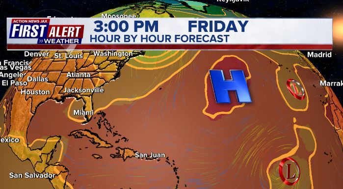
So some good news!: For right now, the Bermuda High across the Atlantic is displaced to the east & northeast (see the 500mb forecast for Fri. below) - & generally weaker - into at least early Sept. - important for any potential long track tropical systems coming out of the deep tropics. If the Bermuda High stays weaker, it will be difficult for a long track tropical cyclone to make it all the way across the Atlantic... at least over the next couple of weeks or so. Such a pattern would not help any possible tropical development more to the west.... say - W. Caribbean, Gulf of SW Atlantic, etc. So it’s not time to let your guard down.


Julian & Kate: tropical depression #10 formed early Sat. becoming tropical storm “Kate” Mon. morning but then downgraded to a tropical depression Tue. morning with the last advisory issued Wed. afternoon. Tropical depression #11 became tropical storm “Julian” Sunday morning but was already post-tropical Sun. night. Neither system will re-generate.
Also.... there continue to be some hints of possible gradual tropical development over the Western Caribbean &/or Western Gulf over the next week or so evolving from an area of disorganized storminess over the SW Caribbean (IR sat image below). This will be something to keep a close eye on with potential impacts - it would appear - for Mexico or *possibly* South Texas in the longer range. Proximity to land should limit much development the rest of this week & possibly beyond not to mention marginal atmospheric (shear) conditions. No impacts to Florida in whatever might - or might not - develop.


The peak of the hurricane season (Sept. 10) is fast approaching & ocean temps. remain fit to help maintain tropical cyclones.
Sea surface temps. across the Atlantic are now near to above avg. across much of the basin (2nd image below) & - even more importantly - deep oceanic heat content (which helped “feed” Ida) is impressive & the “equivalent oceanic heat content” - namely depth averaged temperature in the upper 300 m (~984 feet) - is even more impressive all the way from Africa to the Gulf of Mexico. Such an ocean water temp. pattern is conducive to long track deep tropical Atlantic tropical cyclones & can lead to a more favored regime for rapid intensification cycles. From an AMS research paper in ‘08 Mainelli, DeMaria, Shay, Goni: “Results show that for a large sample of Atlantic storms, the OHC variations have a small but positive impact on the intensity forecasts. However, for intense storms, the effect of the OHC is much more significant, suggestive of its importance on rapid intensification. The OHC input improved the average intensity errors of the SHIPS forecasts by up to 5% for all cases from the category 5 storms, and up to 20% for individual storms, with the maximum improvement for the 72–96-h forecasts. The statistical results obtained indicate that the OHC only becomes important when it has values much larger than that required to support a tropical cyclone.” More recent research continues to indicate similar correlations.


Saharan dust. Dry air - yellow/orange/red/pink. Widespread dust is indicative of dry air that can impede the development of tropical cyclones. However, sometimes “wanna’ be” waves will just wait until they get to the other side of the plume then try to develop if everything else happens to be favorable. In my personal opinion, way too much is made about the presence of Saharan dust & how it relates to tropical cyclones.

2021 names..... “Mindy” is the next name on the Atlantic list (names are picked at random by the World Meteorological Organization... repeat every 6 years... historic storms are retired (Florence & Michael in ’18... Dorian in ’19 & Laura, Eta & Iota in ‘20). Last year - 2020 - had a record 30 named storms. The WMO decided beginning in 2021 that the Greek alphabet will be no longer used & instead there will be a supplemental list of names if the first list is exhausted (has only happened twice - 2005 & 2020). More on the history of naming tropical cyclones * here *.


East Atlantic:


Mid & upper level wind shear (enemy of tropical cyclones) analysis (CIMMS). The red lines indicate strong shear:

Water vapor imagery (dark blue indicates dry air):

Deep oceanic heat content continues to increase across the Gulf, Caribbean & deep tropical Atlantic & has become pretty impressive from the Central/NW Caribbean into the Gulf of Mexico:

Sea surface temp. anomalies:

SE U.S. surface map:

Surface analysis centered on the tropical Atlantic:

Surface analysis of the Gulf:

Caribbean:

Atlantic Basin wave forecast for 24, 48 & 72 hours respectively:


The East Pacific:

West Pacific IR satellite:

Global tropical activity:


Cox Media Group
:quality(70)/d1hfln2sfez66z.cloudfront.net/04-19-2024/t_744a0fe392b04fa194c322a11f1cea0c_name_file_960x540_1200_v3_1_.jpg)
:quality(70)/cloudfront-us-east-1.images.arcpublishing.com/cmg/N7YMXJTJYJEFBCXSUI6KPLO7OM.png)
:quality(70)/cloudfront-us-east-1.images.arcpublishing.com/cmg/5DQX77Y4KRDTPJFHATNPCPNWNQ.jpg)
:quality(70)/d1hfln2sfez66z.cloudfront.net/04-19-2024/t_fc027b22dc41498cbd1409c5f61588fd_name_file_960x540_1200_v3_1_.jpg)
:quality(70)/cloudfront-us-east-1.images.arcpublishing.com/cmg/HZPFOA5MBBGRTLTDR2XJJQ6UE4.jpg)