:quality(70)/cloudfront-us-east-1.images.arcpublishing.com/cmg/WW5AJL3ARQUGDQMAQUNSFX4CLE.jpg)
Jacksonville, Fl. — The “Buresh Bottom Line”: Always be prepared!.....First Alert Hurricane Survival Guide... City of Jacksonville Preparedness Guide... Georgia Hurricane Guide.
STAY INFORMED: Get the * FREE * First Alert Weather app
FREE NEWS UPDATES, ALERTS: Action News Jax app for Apple | For Android
WATCH “The Ins & Outs of Hurricane Season”
WATCH “Preparing for the Storm”
READ the First Alert Hurricane Center “Survival Guide”
***** ALWAYS CHECK & RE-CHECK THE LATEST FORECAST & UPDATES! *****
Don’t panic when you see the low pressure moving to the coast north of Jacksonville!
The combination of an upper level low & surface trough of low pressure over the Western Atlantic has led to the development of small but well defined area of low pressure a couple of hundred miles E/NE of Jacksonville. No significant development is likely before reaching the coast, but there is now a chance that there will be enough organization for a brief tropical depression or weak tropical storm as the low approaches the coast north of Jacksonville near the Ga./S. Carolina border Mon. afternoon. So far almost all of the convection is west of the center with t’storms extending southwest all the way to the Fl. Panhandle in association with a surface trough. Heavy rain & gusty winds will accompany the low & the system will be close enough to Jacksonville to help generate some heavier showers & t’storms on its backside over NE Fl./SE Ga. The low will weaken tonight into Tuesday once ashore while moving W/NW but not before producing as much as 2-4″ of rain for parts of Ga. & S. Carolina.
Meanwhile... a tropical wave is moving over the Central Atlantic & continues to march westward. Little development is expected through mid to late week but some long term development is possible near the weekend into the following week.
And additional tropical waves continue to move west off Africa....


Saharan dust. Dry air - yellow/orange/red/pink - is extensive over the Central & Eastern Atlantic. Such widespread dust is common early in the hurricane season:

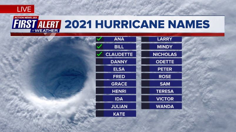
2021 names..... “Danny” is the next name on the Atlantic list (names are picked at random by the World Meteorological Organization... repeat every 6 years... historic storms are retired (Florence & Michael in ’18... Dorian in ’19 & Laura, Eta & Iota in ‘20). Last year - 2020 - had a record 30 named storms. The WMO decided beginning in 2021 that the Greek alphabet will be no longer used & instead there will be a supplemental list of names if the first list is exhausted (has only happened twice - 2005 & 2020). More on the history of naming tropical cyclones * here *.

East Atlantic:


Mid & upper level wind shear (enemy of tropical cyclones) analysis (CIMMS). The red lines indicate strong shear which is widespread from the Gulf of Mexico & Caribbean eastward across much of the Atlantic:

Water vapor imagery (dark blue indicates dry air):

Deep oceanic heat content is slowly increasing across the SE Gulf, Caribbean & deep tropical Atlantic:

Sea surface temp. anomalies:


SE U.S. surface map:

Surface analysis centered on the tropical Atlantic:

Surface analysis of the Gulf:

Caribbean:

Atlantic Basin wave forecast for 24, 48 & 72 hours respectively:


“Enrique” became a hurricane Saturday off the west coast of Mexico over the far Eastern Pacific. Enrique will stay offshore of the far western portion of Mexico before turning more northwest then weakening by early to mid week. But close enough to the coast to produce heavy rain/flash flooding & gusty winds on the coast. Tropical storm & hurricane WARNINGS are up for the coast of Mexico but conditions will improve by Mon. evening. A weakening tropical storm/depression will then move near/over the Southern Baja Peninsula by about midweek.


Global tropical activity:


Cox Media Group

:quality(70)/cloudfront-us-east-1.images.arcpublishing.com/cmg/UPSNZVHYKZE2VDSCN54C3FTF5E.png)
:quality(70)/cloudfront-us-east-1.images.arcpublishing.com/cmg/5BGF6ZRBF5BH3JEEOYZ2JOLJAA.png)
:quality(70)/d1hfln2sfez66z.cloudfront.net/04-23-2024/t_8846f6a1613746e2863363cea1df0c34_name_file_960x540_1200_v3_1_.jpg)
:quality(70)/d1hfln2sfez66z.cloudfront.net/04-22-2024/t_ce7544ba150e4c27a8bfb667adb18b39_name_file_960x540_1200_v3_1_.jpg)
:quality(70)/cloudfront-us-east-1.images.arcpublishing.com/cmg/Z5VHE63WVZHORWO5B25EALQYUA.jpg)