:quality(70)/cloudfront-us-east-1.images.arcpublishing.com/cmg/WW5AJL3ARQUGDQMAQUNSFX4CLE.jpg)
Jacksonville, Fl. — The “Buresh Bottom Line”: Always be prepared!.....First Alert Hurricane Survival Guide... City of Jacksonville Preparedness Guide... Georgia Hurricane Guide.
STAY INFORMED: Get the * FREE * First Alert Weather app
FREE NEWS UPDATES, ALERTS: Action News Jax app for Apple | For Android
WATCH “Talking & Tracking the Tropics: The Science Behind the Season”
WATCH “Preparing for the Storm”
READ the First Alert Hurricane Center “Survival Guide”
***** ALWAYS CHECK & RE-CHECK THE LATEST FORECAST & UPDATES! *****
The Atlantic Basin remains relatively quiet.
However, there are indications of potential low pressure developing over the Northern/Northwest Caribbean by the weekend. The European model is showing the deep upper level trough moving across the U.S. this week being strong enough/far enough south to pull the low northeast to the east of Fl. by early next week & continues north/northeast. The GFS model indicates the opposite & takes the low into the Gulf of Mexico where it then meanders. The UKMET has virtually nothing at this point. So this will be an area to watch as an old front/trough is in the area & will be reinforced by the incoming upper level trough.
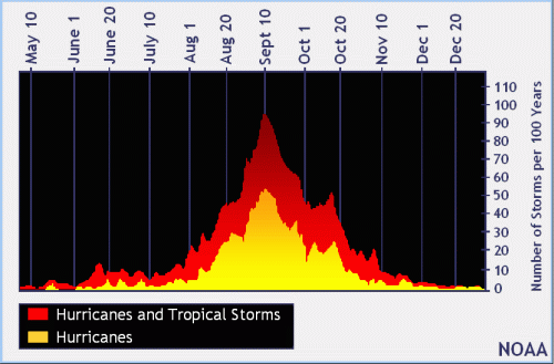
In the longer range.... vertical velocities do appear to become more favorable across the Atlantic Basin by early to mid Oct. “Velocity Potential Anomalies” show a good deal of sinking air (brown lines) right now but more favorable rising air (green lines) should push east from the Pacific generally between Oct. 5 & Oct. 20th which does match a climatological 2nd peak of sorts (Oct. 15-20) for Atlantic tropical development. This doesn’t mean the U.S. is necessarily in trouble, it just means the Atlantic may become more active again.


Atlantic Basin wave forecast for 24, 48 & 72 hours respectively (major wave action at Fl./Ga. beaches through early next week due to persistent brisk onshore flow (high pressure to the north) combined with easterly swells from distant Teddy:


:quality(70)/cloudfront-us-east-1.images.arcpublishing.com/cmg/UPSNZVHYKZE2VDSCN54C3FTF5E.png)
:quality(70)/cloudfront-us-east-1.images.arcpublishing.com/cmg/5BGF6ZRBF5BH3JEEOYZ2JOLJAA.png)
:quality(70)/cloudfront-us-east-1.images.arcpublishing.com/cmg/Z5VHE63WVZHORWO5B25EALQYUA.jpg)
:quality(70)/d1hfln2sfez66z.cloudfront.net/04-22-2024/t_ce7544ba150e4c27a8bfb667adb18b39_name_file_960x540_1200_v3_1_.jpg)
:quality(70)/d1hfln2sfez66z.cloudfront.net/04-23-2024/t_8846f6a1613746e2863363cea1df0c34_name_file_960x540_1200_v3_1_.jpg)