Jacksonville, Fl. — The “Buresh Bottom Line”: Always be prepared!.....First Alert Hurricane Survival Guide... City of Jacksonville Preparedness Guide... Georgia Hurricane Guide.
STAY INFORMED: Get the * FREE * First Alert Weather app
FREE NEWS UPDATES, ALERTS: Action News Jax app for Apple | For Android
WATCH “Talking & Tracking the Tropics: The Science Behind the Season”
WATCH “Preparing for the Storm”
READ the First Alert Hurricane Center “Survival Guide”
***** ALWAYS CHECK & RE-CHECK THE LATEST FORECAST & UPDATES! *****
A brief summary of intense hurricane Laura from last week is at the bottom.....
** Despite multiple areas to track, there will be no direct impacts for Jacksonville/NE Fl./SE Ga. from any tropical systems through the upcoming weekend **
TROPICS:
(1) an area of low pressure north/northeast of Jacksonville was upgraded to tropical depression #15 Mon. afternoon & tropical storm Omar Tue. afternoon. Omar is getting pushed out to the east/northeast ahead of an approaching cold front & upper level trough & accelerate over the next few days. There will be no impacts the U.S. east coast or Bermuda & Omar will soon become post-tropical then dissipate over the N. Atlantic. Steady shear out of the west & southwest is generally keeping the center exposed on satellite imagery & will serve to keep Omar weak. As has been the case much of this season, this is the fastest to ’O’, the 15th storm beating “Ophelia” on Sept. 7, 2005.
(2) the African wave over the Caribbean was upgraded to tropical storm “Nana” Tue. afternoon & reached hurricane strength Wed. evening - the 5th hurricane of the Atlantic season. A pretty straight forward track forecast due to a healthy ridge of high pressure to the north which will send Nana into Belize by early Thu. This will be a Cat. 1 at landfall with a bend more southwest near or shortly after landfall on the central coast of Belize. This is the fastest to ’N’, the 14th tropical storm. The record was “Nate” on Sept. 5, 2005.
(3) There are back to back strong tropical waves over the E. Atlantic & near the coast of Africa. Each will move westward rather slowly into next week with the potential for gradual development. The Bermuda High over the Atlantic is still strong but has shifted northward slowing the movement west of tropical waves.
Also of interest is a buckle (dip) in the jet stream over the middle of the U.S. next week. This trough alone might help to serve up some tropical trouble somewhere relatively close to the U.S. though there’s nothing to lock onto right now.
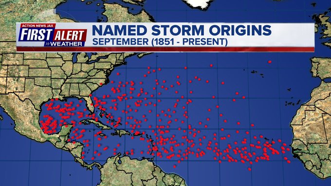
September is usually the most active month of the hurricane season:

Saharan dust:
2020 names..... “Paulette” is next on the Atlantic list (names are picked at random by the World Meteorological Organization... repeat every 6 years... historic storms are retired (Florence & Michael last year) & Dorian is certain to be retired from the ’19 list....
East Atlantic:
Mid & upper level wind shear (enemy of tropical cyclones) analysis (CIMMS). The red lines indicate strong shear:
Water vapor imagery (dark blue indicates dry air):
Deep oceanic heat content is impressive for the first couple weeks of Aug.:
Sea surface temp. anomalies:
SE U.S. surface map:
Surface analysis centered on the tropical Atlantic:
Surface analysis of the Gulf:
Caribbean:
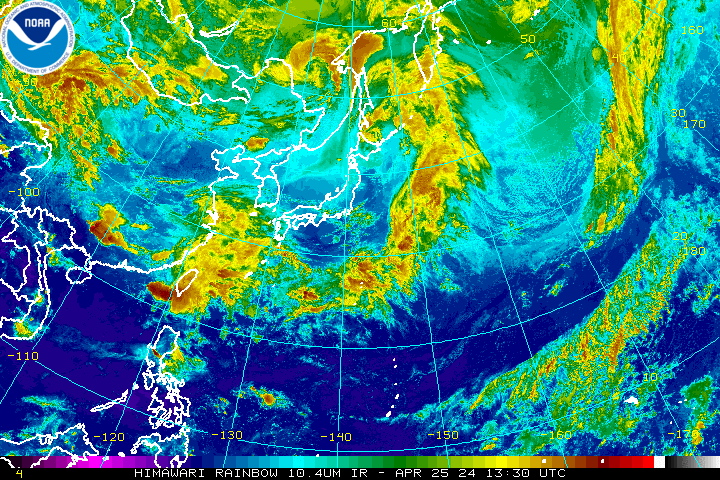
Global tropical activity. It’s interesting to see two typhoons over the far W. Pacific. MIGHT be a hint regarding the movement of future Western Atlantic tropical activity.
“Maysak” moved into South Korea Wed. & was responsible for the sinking of a livestock cargo ship:
“Haishen” will threaten Japan late in the weekend then - again - S. Korea:
LAURA RECAP:
Laura became a weak nontropical low over Eastern Kentucky early Sat. headed for the eastern seaboard near Washington D.C. late Sat. before becoming absorbed by a cold front while moving over the NW Atlantic.
Laura was the 4th Atlantic hurricane of the 2020 season - only 7 other seasons have had as many hurricanes by Aug. 25th - 1886, 1893, 1916, 1966, 1995,1996 & 2005. Landfall was east of the Sabine River about 30 miles south of Lake Charles at Cameron, LA about 1:50am EDT sparing the major metropolitan areas of Houston & New Orleans.
Laura was the 7th named storm to hit U.S. soil this season so far - a record for the number of hits before the end of Aug. (1886 & 1916 had 6 U.S. landfalls)
Strong tropical wave ’98-L’ was upgraded to tropical depression #13 Wed. then to tropical storm “Laura” Fri. while steadily moving west & across or near Puerto Rico, Hispaniola & Cuba... reaching hurricane strength Tue. morning over the Southern Gulf of Mexico the a “major” Cat. 3 hurricane Wed. morning & a Cat. 4 Wed. afternoon - an increase in winds of 75 mph in less than 24 hours & appears to be the fastest intensifying in the Gulf on record! This is also the fastest to the 12th storm breaking the record of “Luis” on Aug. 29, 1995. With the strong Bermuda High to the east, Laura turned more northward through Thu. then northeast into Arkansas & SE Missouri followed by a sharp turn to the east as the jet stream “catches” Laura to the north of the Bermuda High.
A few quick asides on Laura:
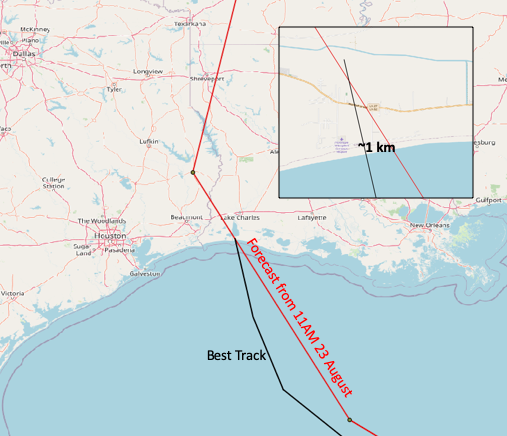
* the track forecast by the NHC was remarkably accurate
* intensity - as is almost always the case - was the toughest forecast but even with Laura, there was ample lead time on a major Cat. 3+ hurricane headed toward the upper Texas coast & SW Louisiana
* storm surge forecasts (15-20 feet) appear to have been a bit too high once the storm reached Cat. 4 intensity but still pretty close. Confirmed values have at least reached 14 feet with post storm surveys still ongoing + at least one measurement east of Cameron (where the eye came ashore) of 17 feet. The area that was hit by the highest storm surge is sparsely populated & mostly wetlands which would have helped absorb some of the surge. A little more west - at the Sabine River - & the higher values would have almost certainly been realized over a large & more populated area. While winds beat the heck out of Lake Charles, the city escaped the worst of the flooding/surge due to the angle of approach of Laura from the south & slightly S/SE. A few “radicals” are mistaking this for a “missed forecast”. Foolish & short sighted.
* as for the forecast models...... virtually all of them struggled with Laura at one time or another. The GFS was too far north & east early on... the European was too weak then too far west once it caught on to intensity... the UKMET was just too strong too early but did catch on the more westward movement earlier than most the other models. The breakdown of the 7-day position errors in nautical miles from best to worst:
GFS: 158
UKMET: 177
European: 186
HMON: 191
TVN: 196
HWRF: 288
CMC: 289
* the upwelling left behind Laura in the Gulf of Mexico is most impressive with large area of superficially cooler water (which will likely mix out within approximately a week).
August hurricane landfalls since 1851 courtesy Dr. Phil Klotzbach. Note that Cat. 4 Laura in SW Louisiana (not on the map) is the first landfall in that geographical area for a major (Cat. 3+) hurricane on record:
Cox Media Group
:quality(70)/cloudfront-us-east-1.images.arcpublishing.com/cmg/WW5AJL3ARQUGDQMAQUNSFX4CLE.jpg)


:quality(70)/cloudfront-us-east-1.images.arcpublishing.com/cmg/76SP2GRIDA2XLKVRJC2ZJNMWSM.jpg)
:quality(70)/cloudfront-us-east-1.images.arcpublishing.com/cmg/7STS2WWQBZEFHM53F6JG4B5PKU.jpg)
:quality(70)/cloudfront-us-east-1.images.arcpublishing.com/cmg/AR5LIUH3ZGV63HJ6N5NKIUDDUI.jpg)
:quality(70)/cloudfront-us-east-1.images.arcpublishing.com/cmg/A5WDDJVOEVBH7AVABNPTTA6C3Y.jpg)
:quality(70)/cloudfront-us-east-1.images.arcpublishing.com/cmg/U3ELGPE42ZFDFK55NGV3FMZQ4U.png)