:quality(70)/cloudfront-us-east-1.images.arcpublishing.com/cmg/WW5AJL3ARQUGDQMAQUNSFX4CLE.jpg)
Jacksonville, Fl. — The “Buresh Bottom Line”: Always be prepared!.....First Alert Hurricane Survival Guide... City of Jacksonville Preparedness Guide... Georgia Hurricane Guide.
STAY INFORMED: Get the * FREE * First Alert Weather app
FREE NEWS UPDATES, ALERTS: Action News Jax app for Apple | For Android
WATCH “Talking & Tracking the Tropics: The Science Behind the Season”
WATCH “Preparing for the Storm”
READ the First Alert Hurricane Center “Survival Guide”
***** ALWAYS CHECK & RE-CHECK THE LATEST FORECAST & UPDATES! *****
A tropical wave over the Eastern Atlantic has some potential for short term development - in the middle of “nowhere” - through the weekend before the wave moves into a hostile environment full of shear & some dry mid & upper level air. Once the wave gets farther west - over the Western Caribbean &/or SW Gulf of Mexico by next weekend or so, conditions may again become more favorable for development.
Overall... the “wave train” off Africa is going strong & it’s likely just a matter of time before we see significant tropical development over the Atlantic.

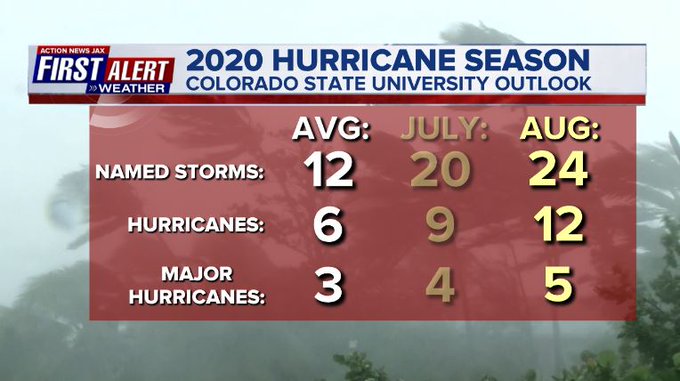
Wed., 08/05 it was Dr. Klotzbach at CSU... Thu., 08/06 it was NOAA with their hurricane season updated forecasts. Both are predicting a potentially historic last half of the hurricane season. Bottom line: always be prepared & stay calm. First Alert Hurricane Center * here *.


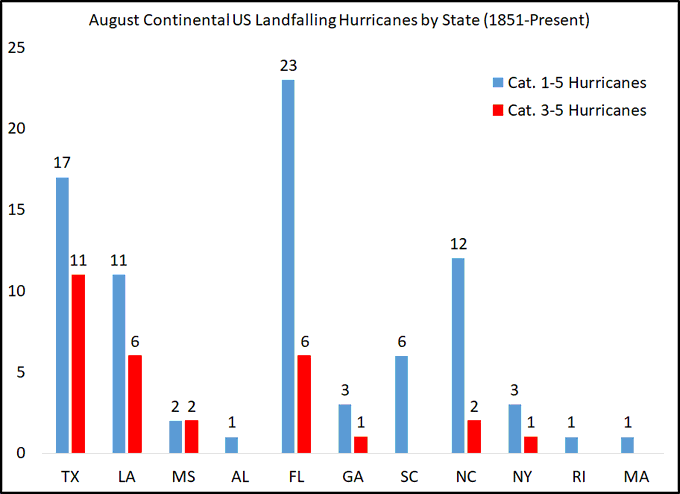
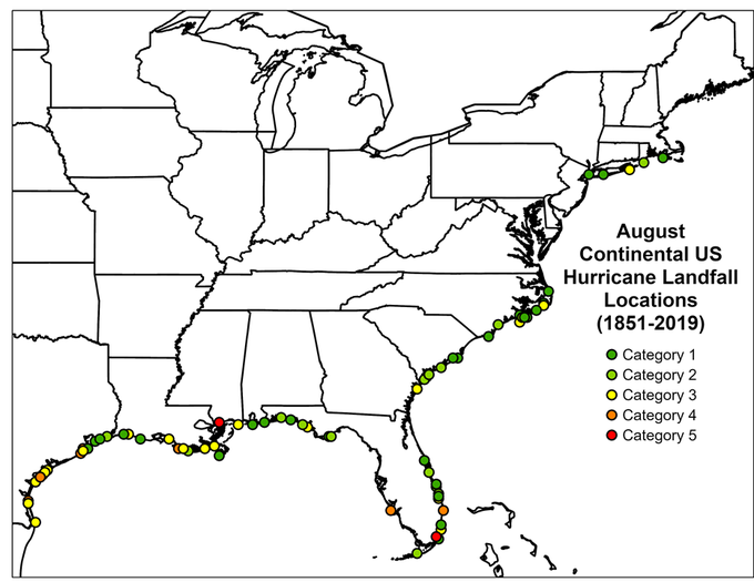
The graph & map below - the next 2 images - courtesy Dr. Phil Klotzbach showing Aug. landfalling hurricanes:


:quality(70)/cloudfront-us-east-1.images.arcpublishing.com/cmg/NZS3DHFYIBFCNMPEVK5ZZLQ6XE.jpg)
:quality(70)/cloudfront-us-east-1.images.arcpublishing.com/cmg/DV3D5PBQIZFEPANBGDDAZHIA5I.jpg)
:quality(70)/cloudfront-us-east-1.images.arcpublishing.com/cmg/YZRADLE76ZHWFLUIEFUTQ4EVR4.jpg)
:quality(70)/cloudfront-us-east-1.images.arcpublishing.com/cmg/N7YMXJTJYJEFBCXSUI6KPLO7OM.png)
:quality(70)/cloudfront-us-east-1.images.arcpublishing.com/cmg/EWZWQ5KMBJDJZOVU6XN73JUD64.jpg)