:quality(70)/cloudfront-us-east-1.images.arcpublishing.com/cmg/WW5AJL3ARQUGDQMAQUNSFX4CLE.jpg)
Jacksonville, Fl. — The “Buresh Bottom Line”: Always be prepared!.....First Alert Hurricane Survival Guide... City of Jacksonville Preparedness Guide... Georgia Hurricane Guide.
STAY INFORMED: Get the * FREE * First Alert Weather app
FREE NEWS UPDATES, ALERTS: Action News Jax app for Apple | For Android
WATCH “The Ins & Outs of Hurricane Season”
WATCH “Preparing for the Storm”
READ the First Alert Hurricane Center “Survival Guide”
***** ALWAYS CHECK & RE-CHECK THE LATEST FORECAST & UPDATES! *****
REMEMBER WHEN A TROPICAL STORM OR HURRICANE IS APPROACHING: Taping windows is *NOT* helpful & will not keep glass from breaking... & realize the cone is the average forecast error over a given time - out to 5 days - & *does not* indicate the width of the storm &/or damage therefore do not become fixated on the center of a tropical system.

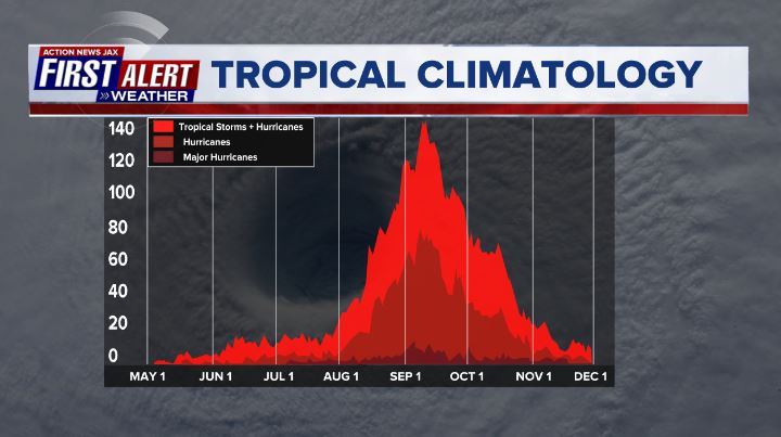
The peak of the hurricane season was Sept. 10th with a mini peak in mid Oct. There is an overall concern regarding a rather late surge in Atlantic tropical activity & potential land impacts discussed in the “Buresh Blog” * here *.
“Peter” & “Rose”:
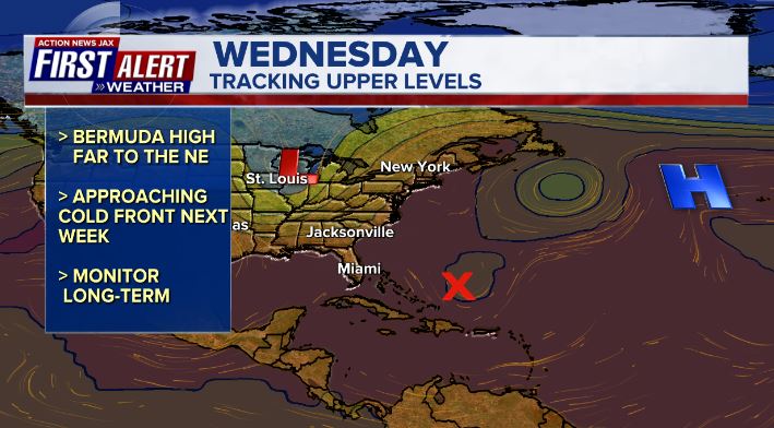
The bad news is two new tropical systems have developed over the open Atlantic. The good news is neither will make it very far across the Atlantic. The overall environment - pockets of strong shear + some dry air - will also likely limit the strength of these tropical cyclones. Even more importantly - the positioning & strength of the Bermuda High in tandem with a fairly constant upper level trough over or near the U.S. east coast. At this point, it seems any systems over the next 10 days to 2 weeks will struggle to make it too far west within a the somewhat marginal environment (which includes “sinking air” too) in addition to an alleyway (weakness/trough of low pressure) over the Western Atlantic that remains in place.
With the fairly swift development/deepening of Peter, the favored track is a move more northwest(vs. west) followed by northward turn through midweek.... & apparently enough of a northwest heading to keep Peter north of the Caribbean & Windward Islands. The European model is more to the west &, therefore, closer to Puerto Rico by Tue./Wed. while the GFS is more east & north. I’m leaning for Peter to stay far enough north so as to not have a major impact on Puerto Rico & nearby areas but this needs to be closely watched.
Meanwhile... tropical depression #17 has strengthened into Rose over the far Eastern Atlantic & should will move much more north than west so is of no concern for any land areas while weakening later in the week.
In the satellite era, only 2005 and 2020 have had the seventeenth named storm on an earlier date.
And “Odette” may try to make a bit of a comeback over the NW Atlantic as the post-tropical cyclone turns more southeast & moves over warmer water again which could help the cyclone become subtropical or perhaps even tropical again while remaining over the open N. Atlantic.


The Bermuda High looks to stay displaced well to the north & east over the Atlantic while a sharp upper level trough moves into the Eastern U.S. Such a set-up should allow for the alleyway to remain over the Western Atlantic which will help turn Atlantic tropical systems more northward before getting very far west.
And an unfavorable MJO phase should keep Atlantic tropical cyclones mostly “in check”. There is a lot of “sinking” (brown lines) air over the Atlantic Basin which doesn’t usually favor strong hurricanes (there can be exceptions!). *But* rising air (green lines) will likely overspread the Atlantic by Oct.

Related to the above discussion - a period of heightened concern for U.S. impacts will evolve toward the end of the month & especially into Oct. - more on that potential *here* in the “Buresh Blog”.
Ocean temps. remain “fit” to help maintain tropical cyclones.
Sea surface temps. across the Atlantic are now near to above avg. across much of the basin (2nd image below) & - even more importantly - deep oceanic heat content (which helped “feed” Ida) is impressive & the “equivalent oceanic heat content” - namely depth averaged temperature in the upper 300 m (~984 feet) - is even more impressive all the way from Africa to the Gulf of Mexico. Such an ocean water temp. pattern is conducive to long track deep tropical Atlantic tropical cyclones & can lead to a more favored regime for rapid intensification cycles. From an AMS research paper in ‘08 Mainelli, DeMaria, Shay, Goni: “Results show that for a large sample of Atlantic storms, the OHC variations have a small but positive impact on the intensity forecasts. However, for intense storms, the effect of the OHC is much more significant, suggestive of its importance on rapid intensification. The OHC input improved the average intensity errors of the SHIPS forecasts by up to 5% for all cases from the category 5 storms, and up to 20% for individual storms, with the maximum improvement for the 72–96-h forecasts. The statistical results obtained indicate that the OHC only becomes important when it has values much larger than that required to support a tropical cyclone.” More recent research continues to indicate similar correlations.


Saharan dust. Dry air - yellow/orange/red/pink. Widespread dust is indicative of dry air that can impede the development of tropical cyclones. However, sometimes “wanna’ be” waves will just wait until they get to the other side of the plume then try to develop if everything else happens to be favorable. In my personal opinion, way too much is made about the presence of Saharan dust & how it relates to tropical cyclones.

2021 names..... “Rose” is the next name on the Atlantic list (names are picked at random by the World Meteorological Organization... repeat every 6 years... historic storms are retired (Florence & Michael in ’18... Dorian in ’19 & Laura, Eta & Iota in ‘20). Last year - 2020 - had a record 30 named storms. The WMO decided beginning in 2021 that the Greek alphabet will be no longer used & instead there will be a supplemental list of names if the first list is exhausted (has only happened twice - 2005 & 2020). More on the history of naming tropical cyclones * here *.


East Atlantic:


Mid & upper level wind shear (enemy of tropical cyclones) analysis (CIMMS). The red lines indicate strong shear:

Water vapor imagery (dark blue indicates dry air):

Deep oceanic heat content continues to increase across the Gulf, Caribbean & deep tropical Atlantic & has become pretty impressive from the Central/NW Caribbean into the Gulf of Mexico:

Sea surface temp. anomalies:

SE U.S. surface map:

Surface analysis centered on the tropical Atlantic:

Surface analysis of the Gulf:

Caribbean:

GFS wave forecast at 48 & 72 hours (2 & 3 days):


Atlantic Basin wave period forecast for 24, 48 & 72 hours respectively:


The East Pacific:


West Pacific IR satellite:

Global tropical activity:


Cox Media Group
:quality(70)/cloudfront-us-east-1.images.arcpublishing.com/cmg/N7YMXJTJYJEFBCXSUI6KPLO7OM.png)
:quality(70)/d1hfln2sfez66z.cloudfront.net/04-18-2024/t_b399b953598a462d8ba0c4539e279e62_name_file_960x540_1200_v3_1_.jpg)
:quality(70)/cloudfront-us-east-1.images.arcpublishing.com/cmg/SKFDOR2IYNE4NDKFR6PGKELN3E.png)
:quality(70)/d1hfln2sfez66z.cloudfront.net/04-17-2024/t_6061b3560fca4ac9aa6b873a534bfe28_name_file_960x540_1200_v3_1_.jpg)
:quality(70)/cloudfront-us-east-1.images.arcpublishing.com/cmg/QHT46DYGFFBQEHWRTYQW7PQQU4.jpg)