:quality(70)/cloudfront-us-east-1.images.arcpublishing.com/cmg/WW5AJL3ARQUGDQMAQUNSFX4CLE.jpg)
Jacksonville, Fl. — The “Buresh Bottom Line”: Always be prepared!.....First Alert Hurricane Survival Guide... City of Jacksonville Preparedness Guide... Georgia Hurricane Guide.
STAY INFORMED: Get the * FREE * First Alert Weather app
FREE NEWS UPDATES, ALERTS: Action News Jax app for Apple | For Android
WATCH “Talking & Tracking the Tropics: The Science Behind the Season”
WATCH “Preparing for the Storm”
READ the First Alert Hurricane Center “Survival Guide”
***** ALWAYS CHECK & RE-CHECK THE LATEST FORECAST & UPDATES! *****
*** SALLY WILL “THROW” A FEW BANDS OF HEAVY SHOWERS & STORMS ACROSS THE LOCAL AREA THROUGH THURSDAY NIGHT ***
So for Jacksonville/NE Fl./SE Ga. impacts from Sally - mainly fringe impacts:
* a few bands of heavy rain/t’storms Wed. afternoon through Thu. evening
* isolated tornado or two, especially west through north of Jacksonville
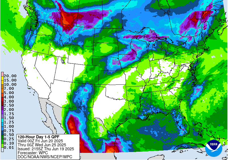
* rainfall potential of 1-2″... heaviest SE Ga. where rainfall may exceed 3″
* breezy winds swinging to out of the south then southwest through Thu. with gusts up to 20-30 mph
* rough seas/surf at area beaches building to at least 4-6 foot breakers over the weekend
* higher than avg. tides - combination of Paulette & Teddy to the east... Sally to the west then north... the new moon phase Thu. Local tide tables * here *.
TROPICS:
(1) an area of ‘disturbed’ weather (showers & storms) that developed over the Bahamas late last week was upgraded to tropical depression #19 Fri. making landfall on the southeast coast of Fl. not far from Miami about 2am EDT Sat. then re-emerged over the warm Gulf by midday Sat. then quickly became tropical storm “Sally” Sat. afternoon. After holding steady state through early Mon., Sally strengthened into a hurricane late Mon. morning & has been slowly moving northwest while wobbling some to the north making landfall about 7am EDT at Gulf Shores, Alabama near the Alabama/Florida border. Sally is the 8th named storm to make a U.S. landfall this season beating the record - by Sept. 16th - of 7 in 1916. 2004 was the last time the U.S. had four hurricane landfalls (Charley, Frances, Gaston & Ivan) by Sept. 16th. Like most of the names this season... this is the fastest to 'S’ beating the record of “Stan” Oct. 2, 2005.
Despite moderate shear & proximity to land, Sally went through a strengthening phase Tue. night a little before landfall near the “Flora-Bama” between Mobile & Pensacola as a Cat. 2 hurricane. While winds are strong, it’s the water (rain & storm surge) that will be most devastating with Sally.
The upper level ridge became “softer” with westerlies - albeit rather weak - extending south to near the Gulf Coast which allowed for a landfall more to the east. After the gradual (slow moving) landfall, there will be a slow turn to the northeast then east/northeast resulting in very heavy rainfall on the order of at least 1-2 feet, locally 30″+! from near Pascagoula to Mobile, Pensacola & Panama City [the Fl. record for a tropical cyclone is 45.2″ at Yankeetown during hurricane “Easy”, 1950... the Alabama record is 36.71″ in 1997 during “Danny”]. Rainfall will still be very heavy but not as extreme inland over Alabama, Georgia & S. Carolina as Sally weakens & starts to move faster. Sally’s remnant low will then move offshore east of the Carolina’s by later Fri./early Sat. There might be an attempt at some reorganization once back over water but by then the system will be moving east & away from the U.S.
As Sally moves more to the east & into Ga. late Wed. - Thursday, a few heavy rain bands & t’storms should develop across Jacksonville/NE Fl. & SE Ga. These bands will be capable of producing brief gusty winds, heavy rain & an isolated tornado or two. The highest tornado risk will be from Lake City to Waycross, Nahunta & Brunswick.


(2) Tropical depression #17 formed over the Eastern Atlantic last Sunday & was upgraded to tropical storm “Paulette” Mon., Sept. 7th The fastest ever to ’P’ easily beating the old record of Philippe Sept. 17, 2005. The forecast is for Paulette to to turn sharply to the northeast & accelerate this week before slowing & turning sharply southeast before becoming a remnant low. Paulette will be an “ocean storm” staying well east of the U.S. *but* moved over Bermuda early Mon. with the entire island enveloped by the eye near 5am EDT.
Though far to the east, easterly swells & an increasing rip current risk affect Florida & much of the Eastern U.S. coast this week even though Paulette will be moving further out to sea. There is some chance that as Paulette turns abruptly south/southeast & moves back over warmer water this weekend into next week that the storm regains tropical or at least subtropical characteristics(!).

(3) Depression #20 formed Sat. from a westbound African tropical wave & was upgraded to “Teddy” early Mon. & to a hurricane early Wed. This is the fastest to the 20th storm breaking the record of an unnamed tropical storm Oct. 4, 2005. Indications are that the Bermuda High to the north will shift more to the east & north allowing for a turn to the north over the Western Atlantic. This will be a clear miss for the Antilles.... & likely stays far to the east of the U.S. but will maintain easterly swells to the U.S. east coast into at least the upcoming weekend/early next week as Teddy will be a large & strong hurricane. There appears to be an increasing threat to Bermuda early next week.

(4) Another African tropical wave was upgraded just off the coast of Africa early Mon. to tropical depression #21 & a few hours later to “Vicky”. This is the fastest to the 20th named storm beating the previous record of Tammy on Oct. 5, 2005 (which made landfall in Duval Co. as a weak tropical storm. There was a “no name” storm before Tammy in ’05 which is why it was a 'T' name as the 20th named storm vs. a 'V' storm this year). Vicky is forecast to weaken & then dissipate over the next couple days.
Yet another African tropical wave will move off the coast later this week with the potential for development.

(5) A lowering of pressures has been indicated by forecast models over the Western Gulf of Mexico into next week. Low pressure may eventually develop & will be an area to keep an eye on for gradual tropical development.
(6) There some indications of possible low pressure developing next week to the east of Florida over the SW Atlantic along what will probably be a stationary front. We’ll need to watch this area for some tropical development.


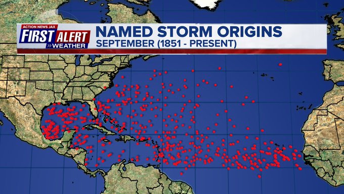
September is usually the most active month of the hurricane season:


:quality(70)/cloudfront-us-east-1.images.arcpublishing.com/cmg/LW2VP2Y6PJDZPLDJCDBZRFVCAI.png)
:quality(70)/cloudfront-us-east-1.images.arcpublishing.com/cmg/NZS3DHFYIBFCNMPEVK5ZZLQ6XE.jpg)
:quality(70)/cloudfront-us-east-1.images.arcpublishing.com/cmg/N7YMXJTJYJEFBCXSUI6KPLO7OM.png)
:quality(70)/cloudfront-us-east-1.images.arcpublishing.com/cmg/CDCX2OOMTZFVDHZVZTXS4IS62E.jpg)
:quality(70)/cloudfront-us-east-1.images.arcpublishing.com/cmg/YZRADLE76ZHWFLUIEFUTQ4EVR4.jpg)