:quality(70)/cloudfront-us-east-1.images.arcpublishing.com/cmg/WW5AJL3ARQUGDQMAQUNSFX4CLE.jpg)
Jacksonville, Fl. — The “Buresh Bottom Line”: Always be prepared!.....First Alert Hurricane Survival Guide... City of Jacksonville Preparedness Guide... Georgia Hurricane Guide.
STAY INFORMED: Get the * FREE * First Alert Weather app
FREE NEWS UPDATES, ALERTS: Action News Jax app for Apple | For Android
WATCH “The Ins & Outs of Hurricane Season”
WATCH “Preparing for the Storm”
READ the First Alert Hurricane Center “Survival Guide”
***** ALWAYS CHECK & RE-CHECK THE LATEST FORECAST & UPDATES! *****
There are no areas of concern through at least the weekend across the Atlantic Basin. A rather persistent upper level trough of low pressure is evolving over the Eastern U.S. This trough will likely lead to the development of - perhaps - several nontropical surface low pressure systems near the U.S. east coast &/or Western Atlantic. While not a great concern at the moment, these lows will be something to keep an eye on in the longer range for persistent t’storm clusters &/or an attempt at transition to subtropical or tropical systems.
.... Lots of Saharan dust is over the Central & Eastern Atlantic right now, but these waves might be a hint of things to come in the long range &, of course, something to always track once out of the more hostile atmospheric conditions.


Saharan dust. Dry air - yellow/orange/red/pink - is extensive over the Central & Eastern Atlantic. Such widespread dust is common early in the hurricane season - through July - & is indicative of dry air that can impede the development of tropical cyclones. However, sometimes “wanna’ be” waves will just wait until they get to the other side of the plume then try to develop if everything else happens to be favorable.

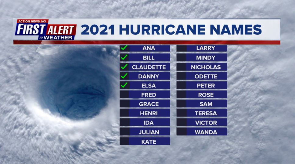
2021 names..... “Fred” is the next name on the Atlantic list (names are picked at random by the World Meteorological Organization... repeat every 6 years... historic storms are retired (Florence & Michael in ’18... Dorian in ’19 & Laura, Eta & Iota in ‘20). Last year - 2020 - had a record 30 named storms. The WMO decided beginning in 2021 that the Greek alphabet will be no longer used & instead there will be a supplemental list of names if the first list is exhausted (has only happened twice - 2005 & 2020). More on the history of naming tropical cyclones * here *.


East Atlantic:


Mid & upper level wind shear (enemy of tropical cyclones) analysis (CIMMS). The red lines indicate strong shear which is widespread from the Gulf of Mexico & Caribbean eastward across much of the Atlantic:

Water vapor imagery (dark blue indicates dry air):

Deep oceanic heat content is slowly increasing across the SE Gulf, Caribbean & deep tropical Atlantic:

Sea surface temp. anomalies:


SE U.S. surface map:

Surface analysis centered on the tropical Atlantic:

Surface analysis of the Gulf:

Caribbean:

Atlantic Basin wave forecast for 24, 48 & 72 hours respectively:


Felicia is weakening over the East Pacific staying well to the south & southeast of Hawaii late in the week as the system dissipates.
Guillermo - follows & is moving west - no threat to any land areas as it, too dissipates in the coming days.


And tropical cyclone “In-Fa” looks to impact Northern Taiwan by late week staying well south of Japan while typhoon “Cempaka” winds down after hitting the south coast of China.

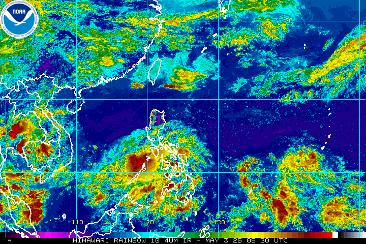

Global tropical activity:


Cox Media Group

:quality(70)/cloudfront-us-east-1.images.arcpublishing.com/cmg/Z5VHE63WVZHORWO5B25EALQYUA.jpg)
:quality(70)/cloudfront-us-east-1.images.arcpublishing.com/cmg/PVJBBQL5O6HVUJYYR7XTO3547I.jpg)
:quality(70)/d1hfln2sfez66z.cloudfront.net/04-22-2024/t_2ed9b79169dc4769babdade6a9c7c303_name_file_960x540_1200_v3_1_.jpg)
:quality(70)/cloudfront-us-east-1.images.arcpublishing.com/cmg/E3E33UY6NZANFHUKTNRXYLDQCY.jpg)
:quality(70)/d1hfln2sfez66z.cloudfront.net/04-23-2024/t_02fb36f9af8940ca82fe77657ce3dceb_name_file_960x540_1200_v3_1_.jpg)