:quality(70)/cloudfront-us-east-1.images.arcpublishing.com/cmg/WW5AJL3ARQUGDQMAQUNSFX4CLE.jpg)
Jacksonville, Fl. — The “Buresh Bottom Line”: Always be prepared!.....First Alert Hurricane Survival Guide... City of Jacksonville Preparedness Guide... Georgia Hurricane Guide.
STAY INFORMED: Get the * FREE * First Alert Weather app
FREE NEWS UPDATES, ALERTS: Action News Jax app for Apple | For Android
WATCH “The Ins & Outs of Hurricane Season”
WATCH “Preparing for the Storm”
READ the First Alert Hurricane Center “Survival Guide”
***** ALWAYS CHECK & RE-CHECK THE LATEST FORECAST & UPDATES! *****
REMEMBER WHEN A TROPICAL STORM OR HURRICANE IS APPROACHING: Taping windows is *NOT* helpful & will not keep glass from breaking... & realize the cone is the average forecast error over a given time - out to 5 days - & *does not* indicate the width of the storm &/or damage therefore do not become fixated on the center of a tropical system.

A little NE Fl./SE Ga. tropical hurricane history:
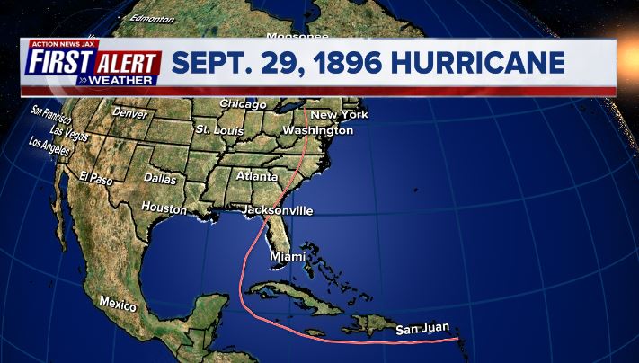
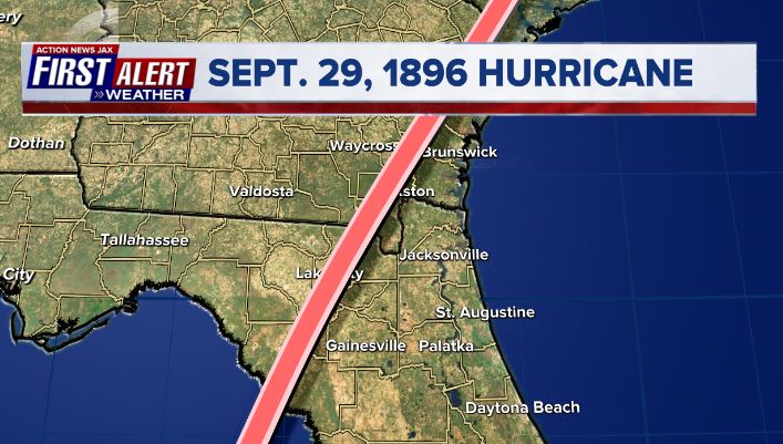
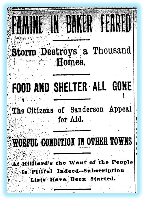
It was 125 year ago on Sept. 29, 1896 that the great “Cedar Keys Hurricane” blew through parts of Fl. & the Southeast U.S. The fast-moving Cat. 2-3 hurricane moved NE near 25 mph to just west of Jacksonville producing a period of sustained hurricane force winds across NE Fl./SE Ga. including sustained winds measured at 76 mph in Jacksonville - something that never occurred during “Matthew” in 2016 or “Irma” in 2017. The 1896 hurricane was born from an African tropical wave, moved through the Northern Caribbean then turn sharply northward through the Yucatan Channel before accelerating & strengthening over the Eastern Gulf of Mexico followed by the Northwest Fl. landfall in the early morning hours. Damage across Northeast Fl. and Southeast Ga. was widespread and severe with food and clothing donated from Jacksonville to the hardest hit areas of Nassau, Baker and Columbia County including Hilliard, Sanderson and Lake City.

ATLANTIC BASIN OUTLOOK:
Accordiing to Dr. Phil Klotzbach 2021 is now tied with last year for the most Atlantic named storms - 14 - to form between 11 August - 24 September on record. Teresa was the 7th named storm to form this month but another brief system - “alive” less than 48 hours - the 9th such “storm” this season. Only 4 seasons on record have had 8+ Sept. tropical cyclones: 2002, 2007, 2010, 2020. Sam was the 2nd earliest formation of the 18th named storm in the Atlantic basin, moving ahead of the infamous 2005 hurricane season, and only trailing last year.
“Sam”:
The strong tropical wave - ‘98-L’ - was upgraded Wed. afternoon to tropical depression #18 then to tropical storm “Sam” Thursday morning & to a hurricane early Friday (avg. date for the 7th Atlantic hurricane is Nov. 16) while marching westward initially at a lower (more south) latitude than previous waves. Sam is a compact/intense storm & should essentially be in a steady state for at least the next several days minus some fluctuations due to structural changes & eyewall replacement cycles. Though staying far to the east, an easterly swell & heightened rip current risk will affect much of the eastern U.S. seaboard by late in this week into the weekend, including NE Fl./SE Ga. It looks like Bermuda will be spared a direct hit but there will be at least some impacts Fri.-Sat. in the form of very rough seas & a gusty wind as Sam moves by to the east of the island.
As for the steering of Sam... it’s clear the GFS model - for days now - has been on to where Sam is going & how strong it will be. The European model has joined in. The steering pattern is well established & few significant track forecast changes are expected as the hurricane finally reaches the N. Atlantic late in the weekend into early next week at which time Sam will become a large & strong post-tropical ocean storm.
Ultimately... the end result - Sams’ track - is being driven by September’s re-adjustment of the upper level flow across the Northern Hemisphere which includes a pretty persistent trough the last several weeks over & near the Eastern U.S. & Western Atlantic. If the trough stays, the U.S. eastern seaboard is protected. The GFS model has ruled the hurricane season so far & there’s no reason to get off the stallion now, so I’ll maintain the turn north then rather sharply northeast through there will be a brief more W/NW movement into early Thu.
Tropical Depression #20:
A strong tropical wave that moved off the coast of Africa Tue. has been upgraded to tropical depression #20 Wed. morning & is very impressive on satellite photos & will likely be “Victor” soon. But it looks like this one will move rather sharply northward as it rapidly intensifies keeping the tropical cyclone far to the east over the open Atlantic with a sustained weakening trend next week over cooler water & increasing shear - no threat to land.
Between the African wave & Sam, an area of low pressure is developing but seems to be struggling due to the close proximity of t.d. #20 to its east. But as/if the the two systems can separate enough, there may be some eventual development while this disturbance moves more westward.... at least initially.


Notice Sam is coming out of a good deal of African dust (brown/gray area on the satellite below) but the tight inner core of the tropical cyclone has generally protecting the storm from most of the dry air:


Sam spaghetti plots:


T.D. #20:

‘91-L’:


The Bermuda High looks to stay displaced well to the north & east over the Atlantic while a sharp upper level trough moves into the Eastern U.S. Such a set-up allows for the alleyway to remain over the Western Atlantic through at least this weekend.

And an unfavorable MJO phase has generally helped keep recent Atlantic tropical cyclones mostly “in check”, but that’s about to change. There is a lot of “sinking” (brown lines) air over the Atlantic Basin which doesn’t usually favor a good deal of tropical development (there can be exceptions!). *But* the rising air (green lines) will likely overspread the Atlantic as we head into Oct. leading to a potentially active 2nd to the last month of the Atlantic hurricane season. During this evolution, we’ll need to monitor the Caribbean & Gulf of Mexico where we’re already getting some occasional - albeit inconsistent - hints from long range models of tropical development.

Ocean temps. remain “fit” to help maintain tropical cyclones.
Sea surface temps. across the Atlantic are now near to above avg. across much of the basin (2nd image below) & - even more importantly - deep oceanic heat content (which helped “feed” Ida) is impressive & the “equivalent oceanic heat content” - namely depth averaged temperature in the upper 300 m (~984 feet) - is even more impressive all the way from Africa to the Gulf of Mexico. Such an ocean water temp. pattern is conducive to long track deep tropical Atlantic tropical cyclones & can lead to a more favored regime for rapid intensification cycles. From an AMS research paper in ‘08 Mainelli, DeMaria, Shay, Goni: “Results show that for a large sample of Atlantic storms, the OHC variations have a small but positive impact on the intensity forecasts. However, for intense storms, the effect of the OHC is much more significant, suggestive of its importance on rapid intensification. The OHC input improved the average intensity errors of the SHIPS forecasts by up to 5% for all cases from the category 5 storms, and up to 20% for individual storms, with the maximum improvement for the 72–96-h forecasts. The statistical results obtained indicate that the OHC only becomes important when it has values much larger than that required to support a tropical cyclone.” More recent research continues to indicate similar correlations.


Saharan dust. Dry air - yellow/orange/red/pink. Widespread dust is indicative of dry air that can impede the development of tropical cyclones. However, sometimes “wanna’ be” waves will just wait until they get to the other side of the plume then try to develop if everything else happens to be favorable. In my personal opinion, way too much is made about the presence of Saharan dust & how it relates to tropical cyclones.

2021 names..... “Victor” is the next name on the Atlantic list (names are picked at random by the World Meteorological Organization... repeat every 6 years... historic storms are retired (Florence & Michael in ’18... Dorian in ’19 & Laura, Eta & Iota in ‘20). Last year - 2020 - had a record 30 named storms. The WMO decided beginning in 2021 that the Greek alphabet will be no longer used & instead there will be a supplemental list of names if the first list is exhausted (has only happened twice - 2005 & 2020). More on the history of naming tropical cyclones * here *.


East Atlantic:


Mid & upper level wind shear (enemy of tropical cyclones) analysis (CIMMS). The red lines indicate strong shear:

Water vapor imagery (dark blue indicates dry air):

Deep oceanic heat content continues to increase across the Gulf, Caribbean & deep tropical Atlantic & has become pretty impressive from the Central/NW Caribbean into the Gulf of Mexico:

Sea surface temp. anomalies:

SE U.S. surface map:

Surface analysis centered on the tropical Atlantic:

Surface analysis of the Gulf:

Caribbean:

GFS wave forecast at 48 & 72 hours (2 & 3 days):


Atlantic Basin wave period forecast for 24, 48 & 72 hours respectively:


The East Pacific:
The eastern North Pacific (ENP; to 180°) has had only 1 named storm form (Olaf) this month, and no tropical cyclones are anticipated in next 5 days per NHC. Accordiing to Klotzbach: “Only 5 Septembers since 1970 have had just 1 ENP named storm form: 1971, 1974, 1979, 2020, 2011″.


West Pacific IR satellite:
“Mindulle” is formidable typhoon while turning sharply north then northeast over the open W. Pacific which has been a helpful hint with “Sam” over the Central Atlantic (typhoon teleconnection with a persistent trough near the east coast of China mirroring the trough near the Eastern U.S.) In other words, Sam turning more north vs. a more west movement. Mindulle will be east of Japan through the weekend.


Global tropical activity:


Cox Media Group
:quality(70)/cloudfront-us-east-1.images.arcpublishing.com/cmg/ZZK7TPO5QFAK3OMFI2ZFKJYRNE.png)
:quality(70)/cloudfront-us-east-1.images.arcpublishing.com/cmg/IWTECV7LPNEVDO2M5OC24TOHEU.jpg)
:quality(70)/cloudfront-us-east-1.images.arcpublishing.com/cmg/2Y6P7UIUZZGYBDCHMSOQKT3P4M.jpg)
:quality(70)/cloudfront-us-east-1.images.arcpublishing.com/cmg/A5WDDJVOEVBH7AVABNPTTA6C3Y.jpg)
:quality(70)/cloudfront-us-east-1.images.arcpublishing.com/cmg/HGILYUISKBFNTDL6GNFIZTC6PA.jpg)