:quality(70)/cloudfront-us-east-1.images.arcpublishing.com/cmg/WW5AJL3ARQUGDQMAQUNSFX4CLE.jpg)
Jacksonville, Fl. — The “Buresh Bottom Line”: Always be prepared!.....First Alert Hurricane Survival Guide... City of Jacksonville Preparedness Guide... Georgia Hurricane Guide.
STAY INFORMED: Get the * FREE * First Alert Weather app
FREE NEWS UPDATES, ALERTS: Action News Jax app for Apple | For Android
WATCH “Talking & Tracking the Tropics: The Science Behind the Season”
WATCH “Preparing for the Storm”
READ the First Alert Hurricane Center “Survival Guide”
***** ALWAYS CHECK & RE-CHECK THE LATEST FORECAST & UPDATES! *****
-- THERE WILL BE *NO DIRECT* IMPACTS FROM TROPICAL SYSTEMS FOR JACKSONVILLE/NE FL./SE GA. THROUGH THE MIDDLE OF THE WEEK --
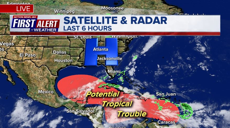
Overall... the Caribbean & Gulf of Mexico continue to be areas to watch for at least the next couple weeks... along with nearby areas of the SW Atlantic. If traveling anytime soon to any areas susceptible to tropical systems, stay up to date on the latest, updated forecast......
Tropical depression #25 formed over the Western Caribbean Fri. morning & strengthened into tropical storm “Gamma” Fri. evening & would have reached hurricane strength Sat. had it not been for landfall on the Yucatan Peninsula about 1pm EDT. It’s the fastest ever to the 24th tropical storm of the season beating the record of Oct. 27, 2005.
The combination of a tropical wave, lower pressures & an old front developed low pressure at the surface over the far Western Caribbean which was upgraded Fri. to t.d. #25 then tropical storm Gamma Fri. evening. The GFS model has been superior so far indicating a more northward move over the weekend. Most models now seem to be catching on. Despite the northward move into the warm water of the far Southern Gulf, Gamma is now near an area of high shear that will not change much in the coming days. The shear (out of the southwest) is very evident on satellite imagery as the center is well southwest of the strong convection. Therefore - despite an uptick in intensity Sunday for a while - Gamma is likely to weaken - or at best hold steady state - as it starts a move west/southwest across the far Southern/SW Gulf & eventually again near the coast of Yucatan. If Gamma survives the hostile conditions, there’s some potential for “rejuvenation” over the Western Gulf late in the week & over the upcoming weekend.
Meanwhile... the 2nd tropical wave - ’92-L' was upgraded to tropical depression #26 Sun. night & continues to move west/NW across the Caribbean & is destined to become our next Atlantic Basin named storm “Delta” (not like Delta Dawn!, bow to Helen Reddy). But again the jury is still out on exactly what this system does.... or does not do regarding both intensity & movement. Models have been wildly inconsistent amongst themselves not to mention compared to one another. It does seem there may be some interaction with Gamma initially but that there will be a “clean break” by midweek or so. From there, the early indications are a move N/NW then turning more north late in the week as a new upper level trough digs into the Lower 48. This upper level trough - timing, orientation & strength - will be a major player on where the tropical cyclone (Delta) goes & how strong it might be. There has been somewhat better agreement recently in bringing the storm to near the Central Gulf coast by late Thu./Fri. In the official latest NHC forecast, #26 is forecast to become a hurricane over the Gulf & tropical storm &/or hurricane WATCHES/WARNINGS have been issued for parts of Cuba & the Cayman Islands.
Currently there is a good deal of shear over the Gulf of Mexico on the order of 30+ mph that only becomes stronger the more north over the Gulf. This shear will essentially remain in place for the next few days before lessening by the weekend/the following week. By then, Gamma may be a thing of the past... & it remains to be seen if t.d. #26 (Delta) can withstand such strong shear. Another ‘negative’ will be nearby dry mid & upper level air. So for right now at least, it seems the harsh environment may rule the day with regards to Gamma but #26 may be far enough removed from the harsh environment to not only survive but thrive.
A word of caution!: the models continue to struggle with the pattern & the upper level steering currents will be evolving considerably in the coming days
Overall... such a pattern -- dominant high pressure across northern latitudes -- this time of year often does yield tropical trouble that begins in or near the Caribbean. Personally I would be surprised if there was not at least one Cat. 3+ hurricane that develops out of this pattern even though the forecast models are not indicating such for the moment. I don’t type this to try to “cry wolf” - it’s my job to forecast. Hopefully whatever does develop does not end being a major landfalling storm. In any case... stay tuned!
There are multiple tropical waves lined up across the Atlantic (see satellite photos) right now. It looks like the waves farther east will have a hard time making it all the way across the Atlantic & will be encountering increasing shear - typical later in the season.


Water vapor imagery clearly shows the dry mid & upper level air across the NW Gulf:

Shear is very strong across the Gulf of Mexico with Gamma already feeling the effects of the winds that are 30+ mph over the Southern Gulf to 60+ knots(!) over the Northern Gulf:


Persistent, broad & strong high pressure at northern latitudes helping to induce low pressure at lower latitudes:
Through at least mid month.... vertical velocities look to become more favorable across the Atlantic Basin Oct. 10-20 - “ish”. “Velocity Potential Anomalies” show a good deal of sinking air (brown lines) right now but more favorable rising air (green lines) should push east from the Pacific in due time which does match a climatological 2nd peak of sorts (Oct. 15-20) for Atlantic tropical development. This doesn’t mean the U.S. is necessarily in trouble, it just means the Atlantic may become more active again & time will tell where & how storms move.

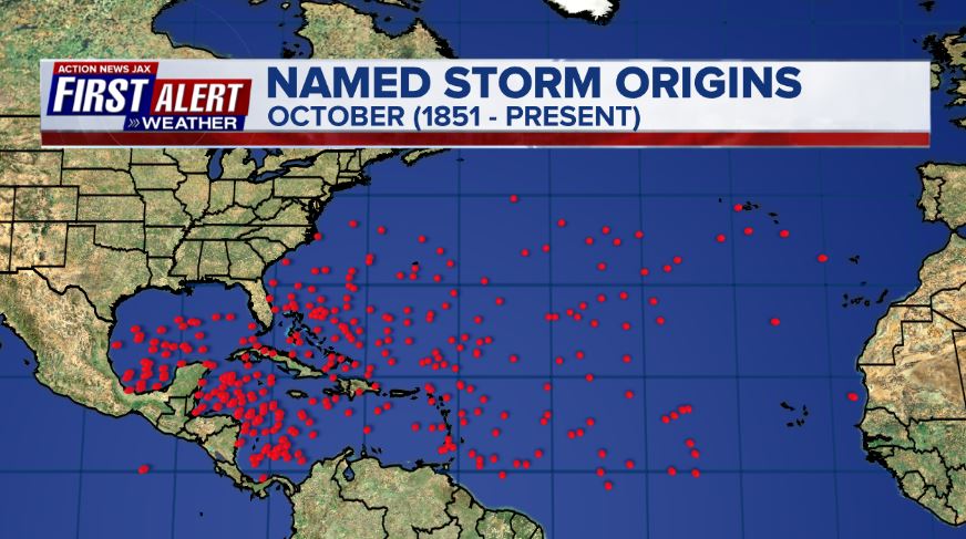
October tropical cyclone origin points are clustered over the Caribbean, Gulf of Mexico & SW Atlantic:
Atlantic Basin wave forecast for 24, 48 & 72 hours respectively (major wave action at Fl./Ga. beaches through early next week due to persistent brisk onshore flow (high pressure to the north) combined with easterly swells from distant Teddy:


:quality(70)/d1hfln2sfez66z.cloudfront.net/04-19-2024/t_744a0fe392b04fa194c322a11f1cea0c_name_file_960x540_1200_v3_1_.jpg)
:quality(70)/cloudfront-us-east-1.images.arcpublishing.com/cmg/LW2VP2Y6PJDZPLDJCDBZRFVCAI.png)

:quality(70)/cloudfront-us-east-1.images.arcpublishing.com/cmg/N7YMXJTJYJEFBCXSUI6KPLO7OM.png)
:quality(70)/cloudfront-us-east-1.images.arcpublishing.com/cmg/HZPFOA5MBBGRTLTDR2XJJQ6UE4.jpg)