:quality(70)/cloudfront-us-east-1.images.arcpublishing.com/cmg/WW5AJL3ARQUGDQMAQUNSFX4CLE.jpg)
Jacksonville, Fl. — The “Buresh Bottom Line”: Always be prepared!.....First Alert Hurricane Survival Guide... City of Jacksonville Preparedness Guide... Georgia Hurricane Guide.
STAY INFORMED: Get the * FREE * First Alert Weather app
FREE NEWS UPDATES, ALERTS: Action News Jax app for Apple | For Android
WATCH “The Ins & Outs of Hurricane Season”
WATCH “Preparing for the Storm”
READ the First Alert Hurricane Center “Survival Guide”
***** ALWAYS CHECK & RE-CHECK THE LATEST FORECAST & UPDATES! *****
Tropical storm Elsa:
* it’s too early to know if there will be impacts - & especially to what degree - on Jacksonville/NE Fl. & SE Ga. - or any of Fl. or the continental U.S.
* anyone traveling to the Caribbean should stay up to date on the latest forecasts. The Lesser Antilles (Windward Islands) will be affected Fri. followed by the Greater Antilles over the weekend
* with the holiday weekend approaching, don’t lose track of this tropical system - continue to get updated forecasts each day
All eyes remain on a the strong tropical wave speeding west/northwest over the Central Atlantic that was upgraded to t.d. #5 late Wed. evening & tropical storm “Elsa” early Thursday. This is the fastest ever to the 5th storm beating the old record of “Edouard” on July 6th, 2020. The storm will gain some latitude (a little more north) while moving W/NW this week. While overall conditions are favorable for strengthening for the moment, the fast movement can sometimes impede intensification of tropical systems (induces some of its own shear). It appears the Bermuda High will remain strong - possibly even expanding some - through the weekend. This set-up should continue to push the wave W/NW into the weekend followed by *possibly* more of a turn to the north. Any turn north will ultimately depend on the strength & positioning of the Bermuda High east of Florida. Another wild card is any land interaction - Hispaniola & Cuba - in particular. Elsa reaches the Central & Southern Lesser Antilles & Eastern Caribbean by early Friday... near Haiti Saturday... & near/over Cuba Sunday.
Forecast models show a variety of solutions which is not surprising at this point. The first few days - through Sat. - are pretty straight forward with a steady, swift movement to the west/northwest. The American GFS model has trended more east recently with a pretty well developed, sometimes even strong tropical cyclone that crosses Cuba then moves into the Southeast Gulf while turning northward & eventually into or near Florida & is still much more west than the Euro. It is worth noting that the GFS model was tweaked during the offseason because of the model missed several developing tropical cyclones last year. The European model had been having a tough time “finding” the wave that’s become Elsa but has trended much better recently. The model takes the system through the Northeast Caribbean & across Hispaniola & seems quite literally “eaten up” by the mountainous terrain then shows Elsa becomeing very diffuse while moving east of Florida & much weaker at that point. Due to the early north turn compared to other models, it’s also faster to bring Elsa into the W. Atlantic (by Mon.). The UKMET model is just about right between the GFS & European but certainly leans toward the GFS crossing Cuba as a strong tropical cyclone then into the SE Gulf as a weaker system. It’s noteworthy that there is a warm eddy of water over the SE Gulf - something to consider if Elsa makes it into that area (image below).
Any impact on Florida looks to be beyond the 4th of July but not by much with at least some fringe effects *possible* for South Florida as early as Monday.

Elsewhere... A “lead” tropical wave has moved into the Eastern Caribbean but is being torn apart by strong shear. Little or no tropical development is expected while another tropical wave has just emerged off the coast of Africa.
And a rather strong - for midsummer - upper level trough will swing into the Eastern U.S. through the weekend developing low pressure near the coast south & southeast of Chesapeake Bay. While some tropical characteristics would be possible, the low will swept quickly off to the east/northeast over the open W. Atlantic.


Elsa spaghetti plots:

The Bermuda High is forecast Sunday to be fairly strong but also rather far to the east over the Central Atlantic. The exact location & strength of the high will be critical on where Elsa goes - its turn to the north - & how fast.


Saharan dust. Dry air - yellow/orange/red/pink - is extensive over the Central & Eastern Atlantic. Such widespread dust is common early in the hurricane season:

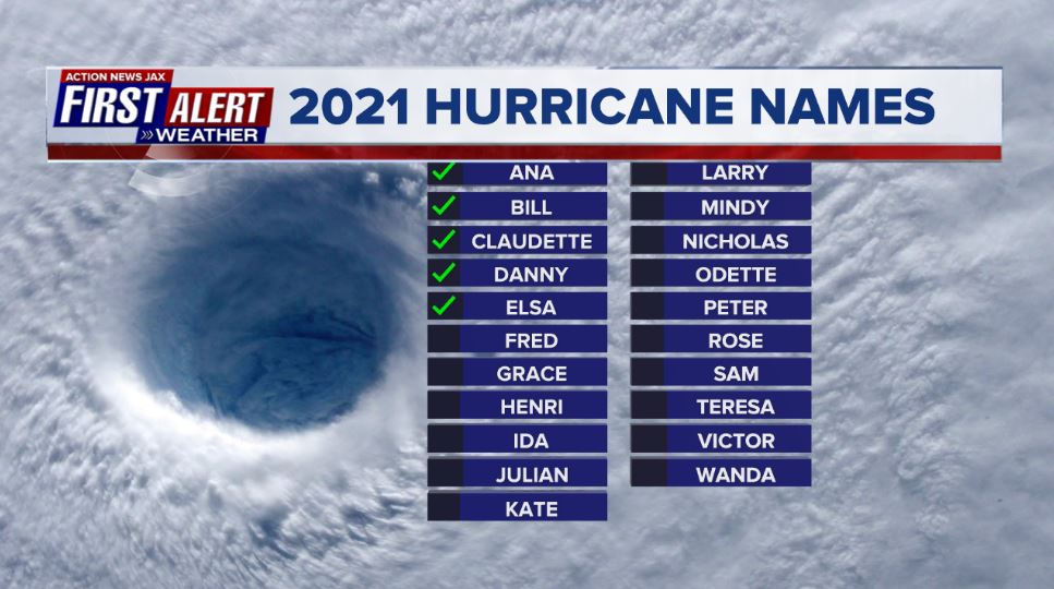
2021 names..... “Fred” is the next name on the Atlantic list (names are picked at random by the World Meteorological Organization... repeat every 6 years... historic storms are retired (Florence & Michael in ’18... Dorian in ’19 & Laura, Eta & Iota in ‘20). Last year - 2020 - had a record 30 named storms. The WMO decided beginning in 2021 that the Greek alphabet will be no longer used & instead there will be a supplemental list of names if the first list is exhausted (has only happened twice - 2005 & 2020). More on the history of naming tropical cyclones * here *.

East Atlantic:


Mid & upper level wind shear (enemy of tropical cyclones) analysis (CIMMS). The red lines indicate strong shear which is widespread from the Gulf of Mexico & Caribbean eastward across much of the Atlantic:

Water vapor imagery (dark blue indicates dry air):

Deep oceanic heat content is slowly increasing across the SE Gulf, Caribbean & deep tropical Atlantic:

Sea surface temp. anomalies:


SE U.S. surface map:

Surface analysis centered on the tropical Atlantic:

Surface analysis of the Gulf:

Caribbean:

Atlantic Basin wave forecast for 24, 48 & 72 hours respectively:


Global tropical activity:


Cox Media Group
:quality(70)/cloudfront-us-east-1.images.arcpublishing.com/cmg/N7YMXJTJYJEFBCXSUI6KPLO7OM.png)
:quality(70)/d1hfln2sfez66z.cloudfront.net/04-19-2024/t_744a0fe392b04fa194c322a11f1cea0c_name_file_960x540_1200_v3_1_.jpg)
:quality(70)/cloudfront-us-east-1.images.arcpublishing.com/cmg/P5YXRPVRDVGPLGMO53SUVUR7TA.png)
:quality(70)/d1hfln2sfez66z.cloudfront.net/04-20-2024/t_50ad93a3ff19442c92d6e1ccd6123c3c_name_file_960x540_1200_v3_1_.jpg)
:quality(70)/d1hfln2sfez66z.cloudfront.net/04-19-2024/t_14ef6ae39b2e47568c35171ec8b4ffd8_name_file_960x540_1200_v3_1_.jpg)