:quality(70)/cloudfront-us-east-1.images.arcpublishing.com/cmg/WW5AJL3ARQUGDQMAQUNSFX4CLE.jpg)
Jacksonville, Fl. — The “Buresh Bottom Line”: Always be prepared!.....First Alert Hurricane Survival Guide... City of Jacksonville Preparedness Guide... Georgia Hurricane Guide.
STAY INFORMED: Get the * FREE * First Alert Weather app
FREE NEWS UPDATES, ALERTS: Action News Jax app for Apple | For Android
WATCH “Preparing for the Storm”
WATCH “The Ins & Outs of Hurricane Season”
READ the First Alert Hurricane Center “Survival Guide”
LISTEN & WATCH “Surviving the Storm” - WOKV Radio & Action News Jax
***** ALWAYS CHECK & RE-CHECK THE LATEST FORECAST & UPDATES! *****
REMEMBER WHEN A TROPICAL STORM OR HURRICANE IS APPROACHING: Taping windows is *NOT* helpful & will not keep glass from breaking.
Realize the forecast cone (”cone of uncertainty”) is the average forecast error over a given time - out to 5 days - & *does not* indicate the width of the storm &/or damage that might occur.

Low pressure is expected to develop over the Western & Northwest Atlantic through the next several days. A weak tropical wave turning northward in the vicinity of this low + an already existing surface trough may all combine for a little extra “energy”. There may be some northward movement late in the week that could bring the low - not likely tropical but possibly subtropical - to near the coast of Maine.
Storminess has been rather persistent over the far SW Caribbean near Central America but proximity to land should limit appreciable development. Still - the NHC has highlighted the Bay of Campeche (far SW Gulf) for the weekend once the tropical wave moves away from interaction with the land mass of Central America & the Yucatan Peninsula. So this is something for the upper coast of Mexico & South Texas to watch though I suspect - at this point - that the system remains weak.
And tropical waves continue to move west off the coast of Africa. Conditions for development look more favorable by the last week or so of this month.


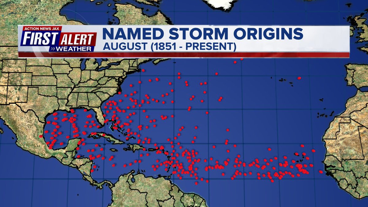
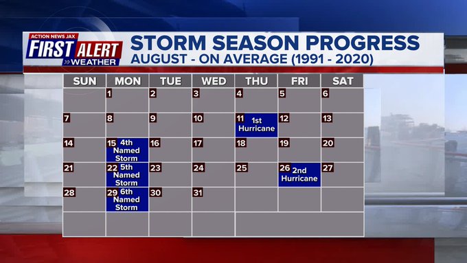
Averages based on climatology for the Atlantic Basin through Aug.:.

Wind shear:


Saharan dust spreads west each year from Africa by the prevailing winds (from east to west over the Atlantic). Dry air - yellow/orange/red/pink. Widespread dust is indicative of dry air that can impede the development of tropical cyclones. However, sometimes “wanna’ be” waves will just wait until they get to the other side of - or away from - the plume then try to develop if other conditions are favorable. In my personal opinion, way too much is made about the presence of Saharan dust & how it relates to tropical cyclones. In any case, we’ve had several large dust plumes spread west to the Caribbean & Gulf with the peak of Saharan dust typically in June & July.

2022 names..... “Danielle” is the next name on the Atlantic list (names are picked at random by the World Meteorological Organization... repeat every 6 years). Historic storms are retired [Florence & Michael in ’18... Dorian in ’19 & Laura, Eta & Iota in ‘20 & Ida in ‘21]). In fact, this year’s list of names is rather infamous with “Charley”, “Frances”, “Jeanne” & “Ivan” retired from the ‘04 list (all hit Fl.) & “Matthew” was retired in 2016. The WMO decided - beginning last year - that the Greek alphabet will be no longer used & instead there will be a supplemental list of names if the first list is exhausted (has only happened three times - 2005, 2020 & 2021). The naming of tropical cyclones began on a consistent basis in 1953. More on the history of naming tropical cyclones * here *.


East Atlantic:


Mid & upper level wind shear (enemy of tropical cyclones) analysis (CIMMS). The red lines indicate strong shear:

Water vapor imagery (dark blue indicates dry air):

Deep oceanic heat content over the Gulf, Caribbean & deep tropical Atlantic:

Sea surface temp. anomalies:


SE U.S. surface map:

Surface analysis centered on the tropical Atlantic:

Surface analysis of the Gulf:

Caribbean:

GFS wave forecast at 48 & 72 hours (2 & 3 days):


Atlantic Basin wave period forecast for 24, 48 & 72 hours respectively:


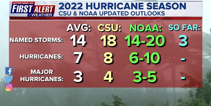
Updated Atlantic seasonal forecast from early Aug. - NOAA & CSU:
The East Pacific:


West Pacific:

Global tropical activity:


Cox Media Group

:quality(70)/cloudfront-us-east-1.images.arcpublishing.com/cmg/Z5VHE63WVZHORWO5B25EALQYUA.jpg)
:quality(70)/cloudfront-us-east-1.images.arcpublishing.com/cmg/E3E33UY6NZANFHUKTNRXYLDQCY.jpg)
:quality(70)/d1hfln2sfez66z.cloudfront.net/04-23-2024/t_0ecd4d40bd604dc8b2116e960d6f2fbb_name_file_960x540_1200_v3_1_.jpg)
:quality(70)/cloudfront-us-east-1.images.arcpublishing.com/cmg/PVJBBQL5O6HVUJYYR7XTO3547I.jpg)
:quality(70)/d1hfln2sfez66z.cloudfront.net/04-22-2024/t_f5f241e0aad44a77a07c6df361d48410_name_file_960x540_1200_v3_1_.jpg)