:quality(70)/cloudfront-us-east-1.images.arcpublishing.com/cmg/WW5AJL3ARQUGDQMAQUNSFX4CLE.jpg)
Jacksonville, Fl. — The “Buresh Bottom Line”: Always be prepared!.....First Alert Hurricane Survival Guide... City of Jacksonville Preparedness Guide... Georgia Hurricane Guide.
STAY INFORMED: Get the * FREE * First Alert Weather app
FREE NEWS UPDATES, ALERTS: Action News Jax app for Apple | For Android
WATCH “The Ins & Outs of Hurricane Season”
WATCH “Preparing for the Storm”
READ the First Alert Hurricane Center “Survival Guide”
***** ALWAYS CHECK & RE-CHECK THE LATEST FORECAST & UPDATES! *****
There are no areas of immediate concern over the Atlantic basin as we move through the first week of the ‘21 hurricane season.
There is a weak upper level low over the Bahamas east of Florida but tropical development is not expected.
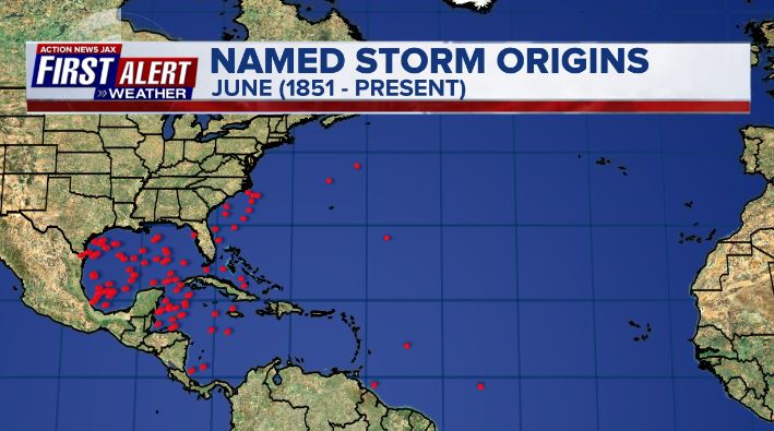
June origin points for tropical cyclones shows the SW Atlantic, NW Caribbean & Gulf of Mexico as the “hot spots” though only about every other June averages a single named storm:
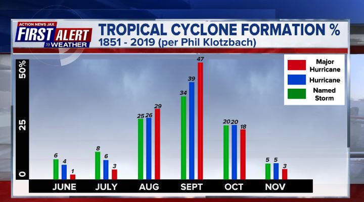
Progression of the hurricane season (tropical storms vs. hurricanes vs. Cat. 3+ hurricanes) through Nov.:
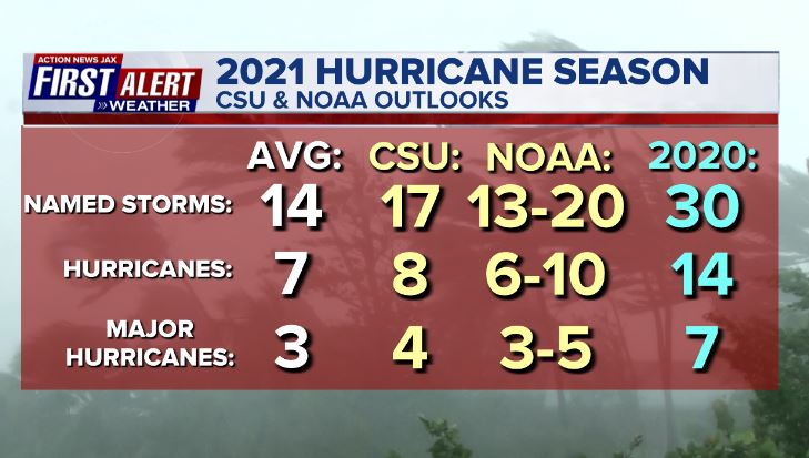
Forecasts are for an active season. Averages have been adjusted based on the 30-year period from 1991-2020.


Saharan dust. Dry air - yellow/orange/red/pink - is extensive over especially the Central & Eastern Atlantic. Such widespread dust is quite common early in the hurricane season:

2021 names..... “Bill” is the next name on the Atlantic list (names are picked at random by the World Meteorological Organization... repeat every 6 years... historic storms are retired (Florence & Michael in ’18... Dorian in ’19 & Laura, Eta & Iota in ‘20). Last year - 2020 - had a record 30 named storms. The WMO decided beginning in 2021 that the Greek alphabet will be no longer used & instead there will be a supplemental list of names if the first list is exhausted (has only happened twice - 2005 & 2020). More on the history of naming tropical cyclones * here *.


East Atlantic:


Mid & upper level wind shear (enemy of tropical cyclones) analysis (CIMMS). The red lines indicate strong shear which is widespread from the Gulf of Mexico & Caribbean eastward across much of the Atlantic:

Water vapor imagery (dark blue indicates dry air):

Deep oceanic heat content is lacking but typical for so early in the season:

Sea surface temp. anomalies:


SE U.S. surface map:

Surface analysis centered on the tropical Atlantic:

Surface analysis of the Gulf:

Caribbean:

Atlantic Basin wave forecast for 24, 48 & 72 hours respectively:


Global tropical activity:


Cox Media Group

:quality(70)/d1hfln2sfez66z.cloudfront.net/04-25-2024/t_b8fa4506d6e24fe496ce983f0ae72d45_name_file_960x540_1200_v3_1_.jpg)
:quality(70)/d1hfln2sfez66z.cloudfront.net/04-24-2024/t_d73855398dca4bf5a6e1eca4fedb0fdd_name_file_960x540_1200_v3_1_.jpg)
:quality(70)/cloudfront-us-east-1.images.arcpublishing.com/cmg/2ONNMC3BENET7KURYKMMLU3UP4.jpg)
:quality(70)/cloudfront-us-east-1.images.arcpublishing.com/cmg/NGMKLAKH5NF27JQOAGV7JN25OU.jpg)
:quality(70)/cloudfront-us-east-1.images.arcpublishing.com/cmg/5BGF6ZRBF5BH3JEEOYZ2JOLJAA.png)