:quality(70)/cloudfront-us-east-1.images.arcpublishing.com/cmg/WW5AJL3ARQUGDQMAQUNSFX4CLE.jpg)
Jacksonville, Fl. — The “Buresh Bottom Line”: Always be prepared!.....First Alert Hurricane Survival Guide... City of Jacksonville Preparedness Guide... Georgia Hurricane Guide.
STAY INFORMED: Get the * FREE * First Alert Weather app
FREE NEWS UPDATES, ALERTS: Action News Jax app for Apple | For Android
WATCH “Talking & Tracking the Tropics: The Science Behind the Season”
WATCH “Preparing for the Storm”
READ the First Alert Hurricane Center “Survival Guide”
***** ALWAYS CHECK & RE-CHECK THE LATEST FORECAST & UPDATES! *****
** LOCAL - JACKSONVILLE/NE FL./SE GA. IMPACTS FROM THE TROPICS THIS WEEK: NOTHING DIRECTLY. EASTERLY SWELLS FROM TEDDY (FAR AWAY TO THE NORTHEAST) ARE ARRIVING AT OUR BEACHES CONTRIBUTING TO DANGEROUS RIP CURRENTS... BETA STAYS WELL TO THE WEST
TROPICS:
(1) Tropical disturbance (90-L) over the Western Gulf of Mexico was upgraded Thu. evening to tropical depression #22. Gradual & then to “Beta” late Fri. (Wilfred, E. Atlantic... “Alpha” NE Atlantic beat it to the punch!). It’s clear that Beta is headed for coastal Texas with a slow turn then to the northeast & will continue to be a poorly organized system. Shear out of the southwest is keeping the storm disorganized with a tilt to the northeast & virtually all of the heavy convection - which has lessened considerably - over the northern & eastern quadrants.
There is also a lot of dry air surrounding Beta. This dry air may - in the end - be the most significant deterrent to strengthening for Beta.
The forecast models are in good agreement with a landfall on the mid Texas coast into Mon. night followed by a slow turn to the northeast near the coast then getting caught up in a mid latitude trough moving across the U.S.
The center is likely to still jump around & re-position itself according to bursts of convection. Despite the recent lack of organized convection, Beta will still be capable of producing heavy rain upon landfall as well as much farther inland across Louisiana & Arkansas due to interaction later this week with a cold front.


Very dry air just to the west of Beta (in addition to 20-35 mph of shear out of the west):


(2) Depression #20 formed Sat. from a westbound African tropical wave & was upgraded to “Teddy” early Mon., Sept. 14th... to a hurricane early Wed. & became a “major” (Cat. 3+) hurricane Thu. reaching a Cat. 4 by late Thu. but has weakened over the weekend. This is the fastest to the 20th storm breaking the record of an unnamed tropical storm Oct. 4, 2005. The Burmuda high shifted more to the east & north allowing for a turn to the north over the Western Atlantic. Teddy stays far to the east of the U.S. - reached Jacksonville’s latitude 1,000+ miles away late Sun./Sunday night - but will maintain easterly swells to the U.S. east coast - & a heightened rip current risk - through the middle of the week as Teddy is a large hurricane. Teddy is going a little east of Bermuda Monday - the 2nd hurricane (Paulette Mon., the 14th) near the island within a week.... & to Nova Scotia & Newfoundland by the middle of the week as Teddy bends back to the northwest then to the north over the NW Atlantic while transitioning to a large/powerful post-tropical ocean storm.


(3) Tropical storm “Wilfred” formed Fri. over the Eastern Atlantic from a strong tropical wave that looked impressive for a couple of days but has now dissipated over the Central Atlantic. Wilfred breaks the record for the fastest to the 21st named storm - “Vincent” on Oct. 8, 2005 (not the same letter because there was unnamed tropical cyclone in ’05 prior ‘V’ & ‘W’ being used). Wilma, by the way, developed in mid Oct., ’05, so we’re nearly a month ahead of 2005 at this point when it comes to use of the Greek alphabet.
(4) There are a couple of tropical waves moving west off Africa but significant development is in doubt.
(5) A stationary front will hang over the SW Atlantic into the Eastern Gulf much of this week. We’ll need to watch for any persistent clusters of t’storms/developing low pressure that might try to “go” tropical. Nothing indicated at the moment..


Atlantic Basin wave forecast for 24, 48 & 72 hours respectively (major wave action at Fl./Ga. beaches through early next week due to persistent brisk onshore flow (high pressure to the north) combined with easterly swells from distant Teddy:


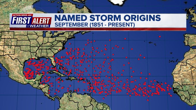
September is usually the most active month of the hurricane season:


:quality(70)/cloudfront-us-east-1.images.arcpublishing.com/cmg/YY26FCT3ONCAJA7FI7C5HBFBSM.jpg)
:quality(70)/cloudfront-us-east-1.images.arcpublishing.com/cmg/YYXW6LTDLJG5TI5GJ4ZE6W6KJ4.jpg)
:quality(70)/d1hfln2sfez66z.cloudfront.net/04-17-2024/t_6061b3560fca4ac9aa6b873a534bfe28_name_file_960x540_1200_v3_1_.jpg)
:quality(70)/d1hfln2sfez66z.cloudfront.net/04-16-2024/t_980912f57edf41ed844a9a1fcf0a511f_name_file_960x540_1200_v3_1_.jpg)
:quality(70)/cloudfront-us-east-1.images.arcpublishing.com/cmg/NQCTWRA7OVFP5ABEQBTBAG2E3A.jpg)