
Sept. 20, 2017 — Photos: Must-see photos of Irma damage in Jacksonville area
Live updates: Maria is a powerful Category 4 hurricane
The Atlantic remains very active with "Jose" off of New England... poweful "Maria" moving into the SW Atlantic.... & "Lee" remnants over the Central Atlantic.....
Only 6 other seasons have had 13 named storms by Sept. 16th - 1933, 1936, 1995, 2005, 2011 & 2012 (Klotzbach).
The "Buresh Bottom Line" is: stay tuned!... Always be prepared!..... City of Jacksonville Preparedness Guide... Georgia Hurricane Guide.
Maria:
LOCAL (JACKSONVILLE) IMPACTS - closest approach will be 500+ miles to the east Sunday night-Monday:
- a high rip current risk this weekend into early next week
- breezy winds out of the northeast (onshore) - especially at & near the coast
- no rainfall..... no high winds .... no storm surge directly associated with Maria for NE Fl./SE Ga.
Maria went Cat. 5 & then some with a minimum pressure of at least 909 mb Tue. evening making the hurricane among the top 10 most intense on record for any part of the Atlantic Basin. Maria is the 2nd Cat. 5 of the season over the Atlantic - the first time that's happened since 2007 (Dean & Felix). An eyewall replacement cycle Tue. night spared Puerto Rico a Cat. 5 hit, but Maria will still be a devastating hit by a high end Cat. 4 hurricane. In fact, all NWS radars have been knocked out on the island. The forecast track is relatively straight forward (if there is a such a thing!) through late week.... but things become more complicated in the long range.
Jose is adding to the confusion as some models show some interaction by the weekend over the Western Atlantic/early next week. Ultimately I don't believe the two tropical cyclones will directly interact but what happens in the atmosphere with & near Jose is helping to dictate Maria's movement in the coming days & whether or not there's a direct hit on the U.S.
It does seem certain that Maria will not be a Gulf of Mexico system.
I am concerned about a more west shift in the long term track overall due to:
(1) upper level ridge that will have the potential to develop underneath (south) of "Jose"
(2) the Atlantic pattern since spring has been dominated by a strong & expansive Bermuda high. Attention to long range model forecasts this season have shown an east & even north bias early in the forecast cycles.
So how do we solve a problem like Maria? Well... much will come down to any upper level ridging near the U.S. east coast. At the moment, virtually all of the long range global models have shifted east following a wake of sorts to the south of northward moving Jose. It's the ol' "cork in a stream" - the hurricane is going to follow the path of least resistance. It's my humble opinion, that Maria is not a simple recurve harmlessly over the W. Atlantic after battering parts of the Caribbean & Bahamas even though models insist mostly east.
Land interaction with Puerto Rico + the Tue. night eyewall replacement cycle have weakened Maria. It'll take a while for the core to recover, but it ought to get the job done by Thu./Fri. resulting in a restrengthening trend over & near the SE Bahamas.


Spaghetti model plot for Maria:

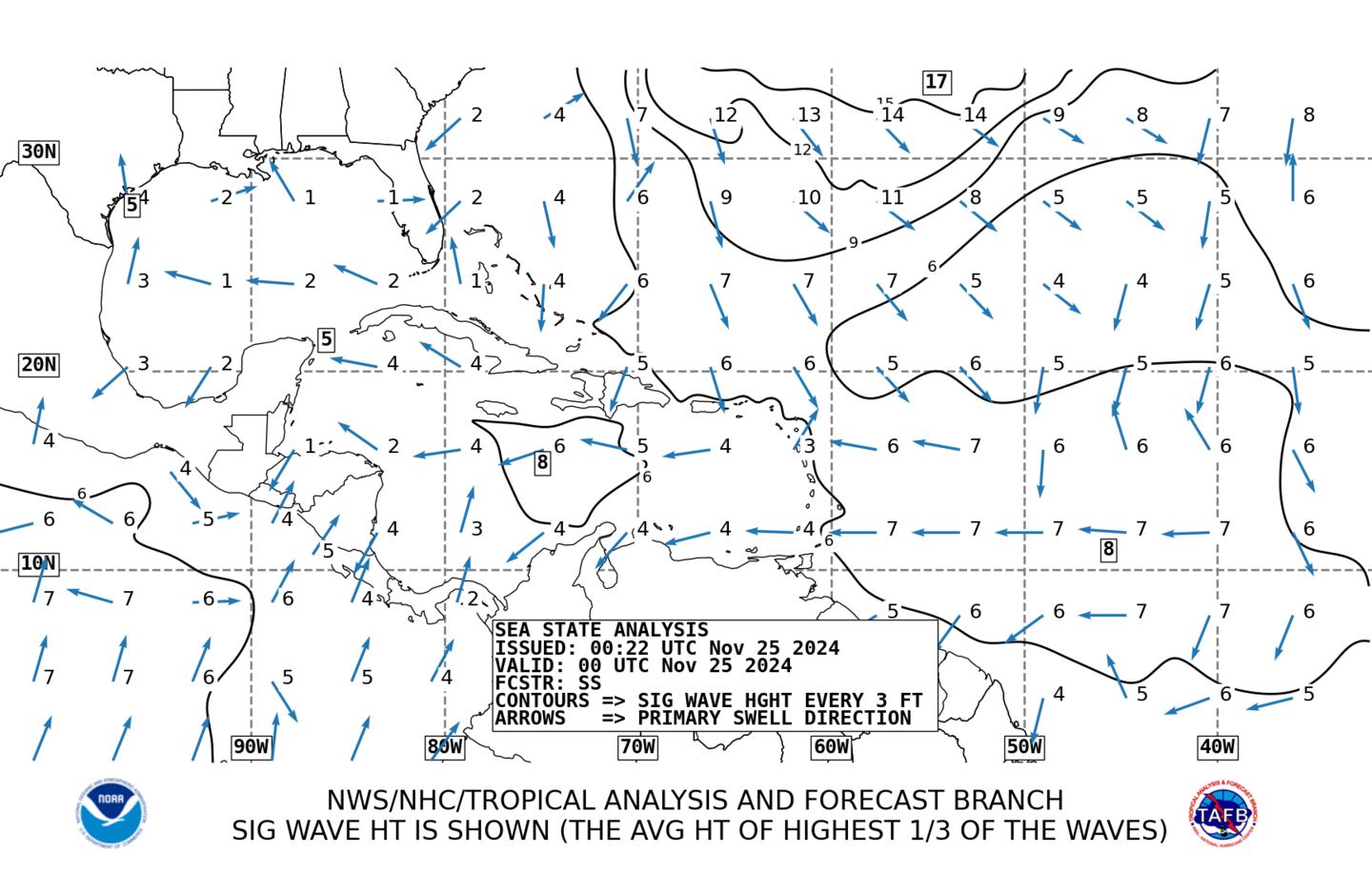
Average wave heights:
The chart below is the 500mb (upper level) forecast from the GFS model for early Sat., 09/23. The atmosphere is going through some major buckling as a big trough of low pressure moves into the Western U.S. helping to induce ridging over the Eastern U.S. But there's just enough "softness" over the W. Atlantic for the models to sniff out an escape route for Maria. I think our best hope is for Jose to be enough of a factor to maintain that alleyway as otherwise ridging should have a tendency to develop given the large trough over the Western U.S. If the ridging is faster & wins out then the U.S. has a problem with regards to Maria.
It is still too early to fully know how these details will work out next week. It is a rather complicated weather pattern. But I am confident that Maria stays well east of Florida so only fringe relatively minor effects on the coast of NE Fl. & SE Ga. - rip currents & breezy winds out of the northeast (onshore).

Jose:
.... The tropical/subtropical storm has made the turn more north & is slowly weakening while also gradually transitioning to a subtropical storm. Jose will do a loop turning back to the west over the weekend into early next week with a possible landfall of what should be a relatively weak system on the mid Atlantic early next week.
There will be no major direct impacts on Fl.. But "Jose" will bring strong winds & rough seas/surf to New England including Boston the rest of this week while a very high rip current risk will occur from the beaches of of the Carolina's to Maine.
LOCALLY - for NE Fl./SE Ga: Jose's closest approach was Sunday BUT 500+ miles to the east. An easterly swell will continue at the coast of Northeast Fl./SE Ga. with an enhanced rip current risk.


Jose....

NOAA WaveWatch III below predicated on GFS model - will change & update - hit refresh for latest + loop:
0
Very warm ocean water persists:
1
Deep oceanic heat content is still very evident - especially over the Caribbean & Gulf. We will have more tropical troubles before the season is over.

Sea surface temp. anomalies show sea surface temps. have cooled across the Northern Gulf & surrounding Fl. most likely caused by the recent tropical cyclones....

"Lee" is still a "thing" over the Central & Eastern Atlantic. There is at least some potential for regeneration, but I do not see "Lee" making it west across the Atlantic.


The Gulf & Caribbean remain quiet. There are indications of a general lowering of surface pressures across this area for late month which might be a hint pointing to tropical "mischief" in 10 days to 2 weeks.

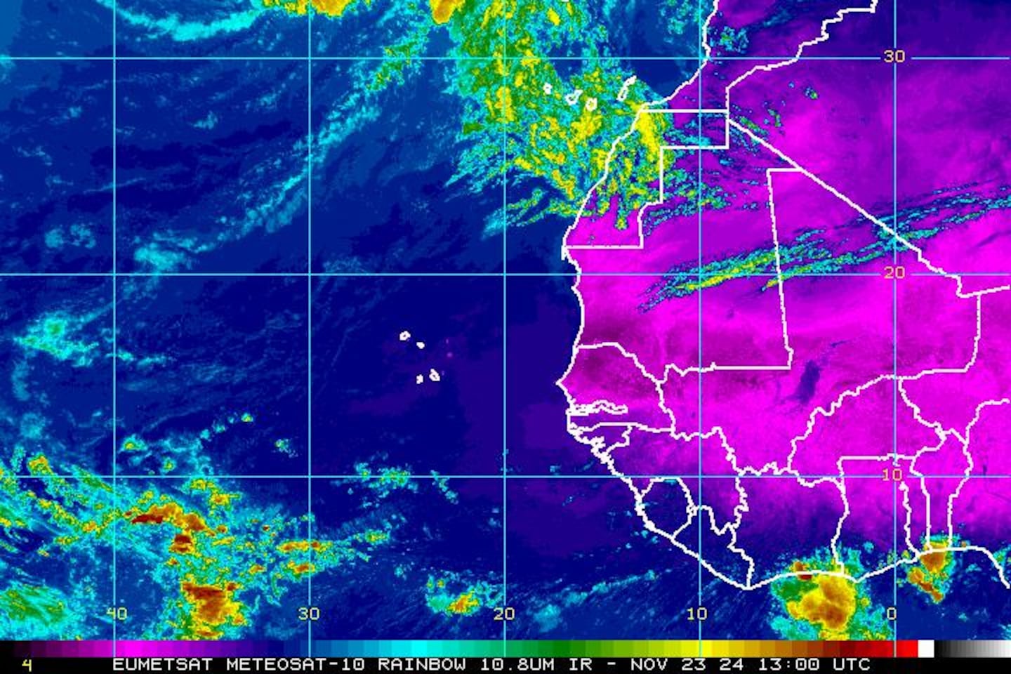
East Atlantic IR satellite:
Mid & upper level wind shear (enemy of tropical cyclones) analysis (CIMMS):

SE U.S. surface map:


Surface analysis centered on the tropical Atlantic:

Surface analysis of the Gulf:

Caribbean:

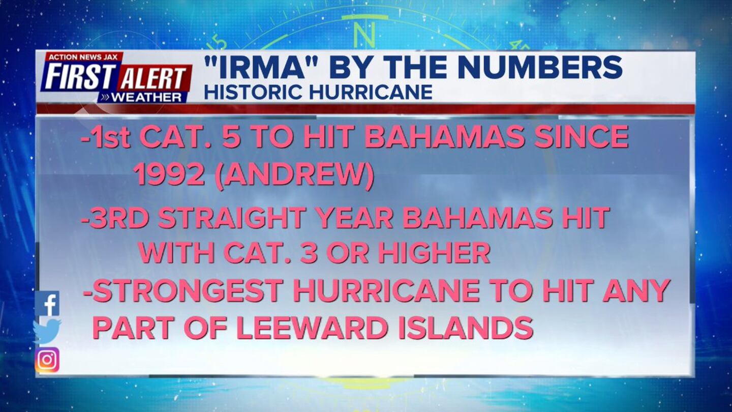
Hurricane Irma recap: made the turn to the northwest & then north after ravaging the Keys. Ft. Myers & much of Florida last weekend into the early part of last week. this is the first "major" Fl. hurricane landfall since Cat. 3 "Wilma" in Oct., 2005 (Twitter did not yet exist!)...
The last advisory by the NHC on "Irma" was issued Tue. morning as the storm became post tropical.


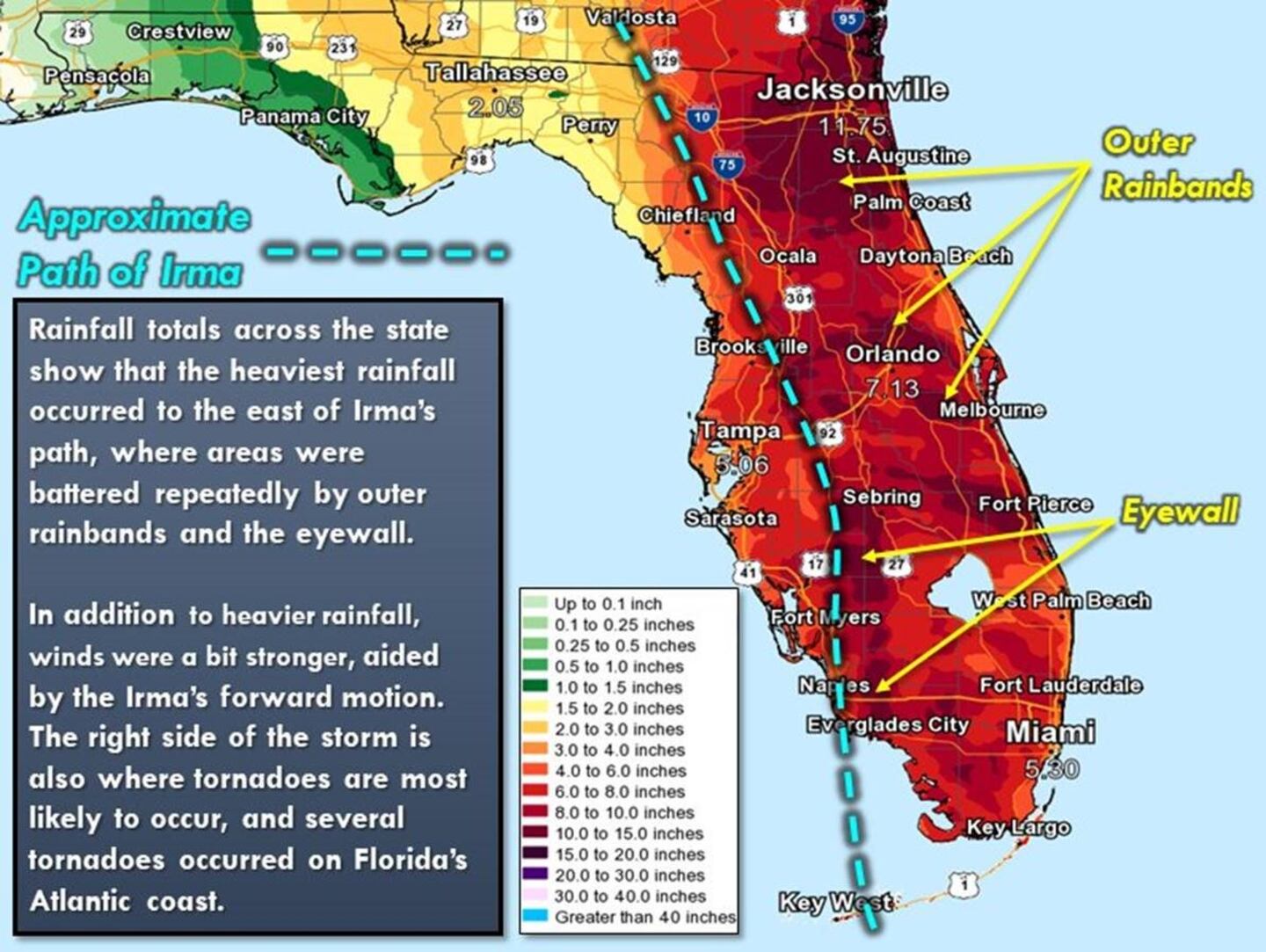
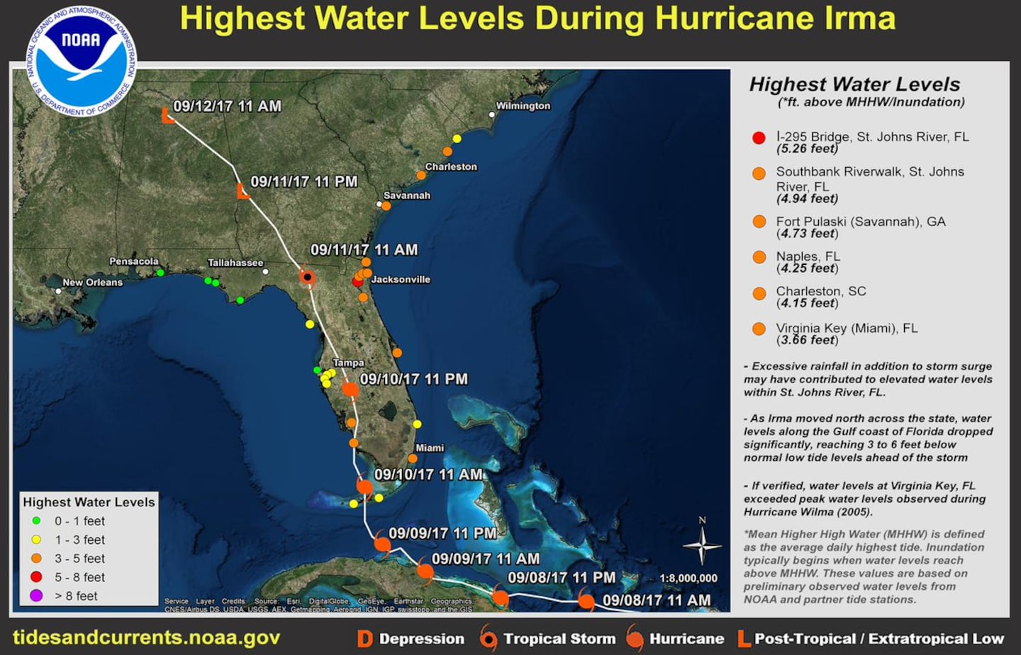
Preliminarily highest water levels from NOAA. Further ground verification will follow & result in some higher numbers ultimately (probably) - especially for the Keys & S. Florida. What pops out is the highest so far is the I-295 Bridge (Buckman)!.... then the southerly wind on the east side of Irma pushed all that water north to downtown resulting in the massive once in a generation flood for Riverside & San Marco. Initial post storm analysis is showing salinity of the St. Johns River at the peak of the "Great Flood" to not be as great as during the peak of flooding during/immediately after Matthew last year.
Cox Media Group


