Aug. 6, 2017 — Tropical storm "Franklin" has formed over the W. Caribbean. Tropical storm WARNING for the Yucatan Peninsula... tropical storm WATCH for upper coastal Belize including Belize City... only four other years have had 4 tropical storms by Aug. 6th - 1936, 1959, 2005 & 2012 (according to Dr. Phil Klotzbach).
Tropical storm "Franklin" will intensify through Mon. but land interaction -- Yucatan Peninsula -- should weaken the system before emerging over the Bay of Campeche where several forecast models show explosive development over what is often a "hot bed" for tropical development this time of year. Given very warm ocean temps. + a low shear environment, intensification is likely as long as the circulation is not too disrupted over land late Mon. through early Tue. The 2nd landfall looks to be Wed. night/early Thu. on the ocast of Mexico.
There will be NO impacts for Jacksonville or any of Florida.


Meanwhile... an active tropical wave ('99-L') has a chance to still develop into a tropical cyclone but is showing no signs of organization for the moment over the Central Atlantic. The GFS model has trended weaker taking little more than an open wave to just east of Florida by next weekend. The European model has flip-flopped back to a weak system with an open wave just east of Florida by early next week... the UKMET model is generally somewhere inbetween & has a weak tropical disturbance approaching the Lesser Antilles & Puerto Rico by the end of the week.
A weaker system would go farther west largely steered by the low level trade winds. For the moment.... I favor a weaker system that ends up farther west - at least initially. The problem could be in the longer term when conditions might be more favorable for stronger development (next weekend, following week - ish).
Other tropical waves are now marching west from Africa as we enter the 6-8 week period when deep Cape (Cabo) Verde tropical systems become more common.


SE U.S.:

0
1
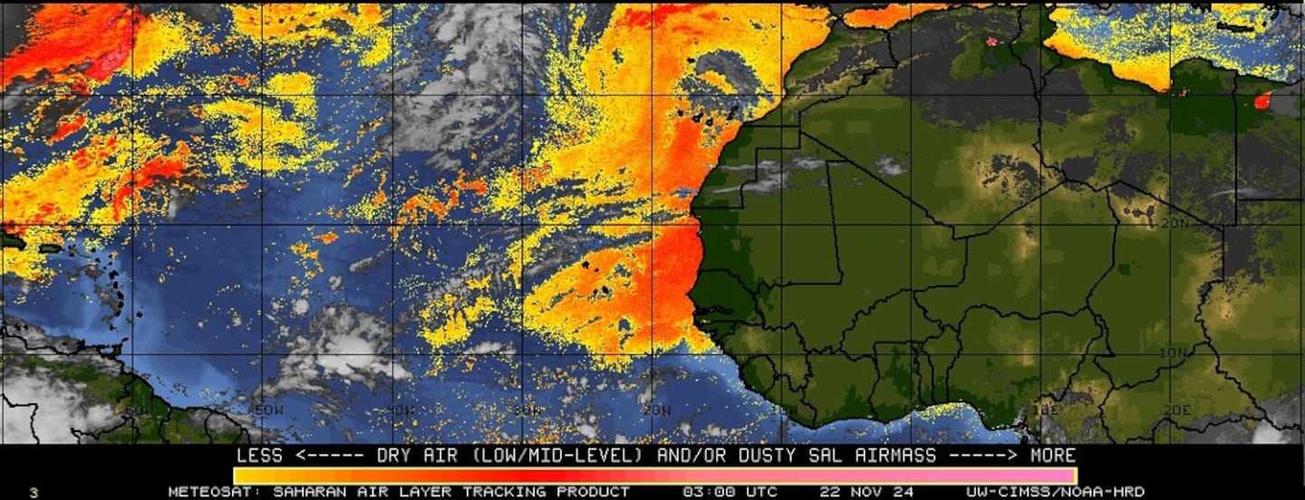
Imagery below courtesy CIMMS continues shows the persistent stream of African Saharan dust (orange & red) breaking up a little but beginning to amass itself again off the NW coast of Africa:
Water vapor imagery shows moisure returning to Florida....

Surface analysis centered on the tropical Atlantic shows the strong Bermuda high remains anchored over the Central Atlantic...

Surface analysis of the Gulf:

Caribbean:

Wind shear analysis (red is stronger shear). '90L' is moving into an area of lower shear near Central America/Southern Gulf of Mexico....

The W. Pacific...... "Noru" is hitting Japan as a Cat. 1 typhoon & will weaken to a tropical storm by Monday as the storm dumps heavy rain throughout Japan (could be cause for concern on wave '99L' now in the E. Atlantic using possible teleconnection):


"Noru":

0
Dr. Phil Klotzbach, Colorado State University updated his seasonal forecast Friday. He increased the total storm number by 1 with an active season still anticipated. If the forecast is accurate, we are in for an awfully active 2-3 months.
1
Cox Media Group