:quality(70)/cloudfront-us-east-1.images.arcpublishing.com/cmg/4BY52YP3URHB3CBG6342FEUNGQ.jpg)
JACKSONVILLE, Fla. — It’s easy to become a member of our First Alert Neighborhood Weather Station Network:
:quality(70)/cloudfront-us-east-1.images.arcpublishing.com/cmg/Y77Y5DTEBJDKDM7252Y7QRYVQQ.png)
It’s still a bit early - especially considering the mid January cold snap - but we’re getting indications of the very beginning of our pollen season. Cedar is usually the earliest & indeed that’s the highest number (but still “only” moderate) from the real-time sampling by Dr. Brian Seymour, Edward Waters University. Unfortunately it’s only up from here with timing of the peaks depending on exact weather conditions & especially temps. (Cedar first then Pine followed by Oak). Last year’s winter & spring was very warm so the numbers peaked early - Cedar on Jan. 11th... PIne peaked on Feb. 1st... & Oak peaked March 8th. We’re likely to see a later peak of each allergen this year.

From Miami University:
South Florida’s Nearshore Reefs Less Vulnerable to Ocean Acidification, Study Finds
Results offer a glimmer of hope as climate change impacts coral reefs worldwide
Researchers studying South Florida’s coral reefs found that the region’s nearshore reefs and more sheltered inshore areas are less vulnerable to ocean acidification than previously thought – a major climate-related threat to coral reefs as ocean waters absorb more atmospheric CO2 from the burning of fossil fuels.
This new study, led by scientists at the University of Miami Rosenstiel School of Marine, Atmospheric, and Earth Science, and the National Oceanic and Atmospheric Administration’s (NOAA) Atlantic Oceanographic and Meteorological Laboratory (AOML) offers a glimmer of hope for Florida’s iconic coral reefs as ocean acidification, along with marine heat waves and other climate-related threats are impacting coral reefs worldwide.
“In contrast to many regions globally where ocean acidification is being exacerbated, we found that South Florida’s inshore reefs — and sheltered areas that co-exist with seagrass communities — are being buffered from the negative effects of acidification,” said the study’s lead author Ana Palacio-Castro, a researcher at the Rosenstiel School-based NOAA Cooperative Institute for Marine and Atmospheric Studies.
Ocean waters absorb atmospheric carbon dioxide, which results in a drop in pH levels, turning the water more acidic. This resulting ocean acidification impacts the ability of a wide range of marine life —from corals to clams—to build and maintain their calcium-based shells and skeletons, and ultimately compromises the structural integrity of coral reefs and the marine life that rely on them.
In this study, the researchers analyzed 10 years of continuous seawater samples collected at 38 monitoring stations across the Florida Reef Tract to assess carbonate chemistry variability among seasons, years, and reef areas, including ocean acidification. They looked at differences between Biscayne Bay and the Upper, Middle, and Lower Keys, and the inshore, mid-channel, and offshore reef zones.
The results showed potential ocean acidification refugia in inshore reefs with neighboring seagrass meadows as a result of enhanced primary production, highlighting the importance of the relationship that exists between coral reef and seagrass ecosystems to mitigate the impacts of future climate changes.
The results also suggest that Florida’s inshore reef structures could benefit from local mitigation strategies, such as reducing CO2 emissions, marine carbon dioxide removal or conserving intact seagrass meadows, according to the researchers.
“The findings underscore the importance of local monitoring to understand how ocean acidification is impacting our region and to identify potential acidification hotspots and refugia,” said Ana Palacio-Castro.
The study, titled “Coral reef carbonate chemistry reveals interannual, seasonal, and spatial impacts on ocean acidification off Florida,” was published in the American Geophysical Union journal Global Biogeochemical Cycles.
The project was supported by the South Florida Ecosystem Restoration Research Program (SFER) at NOAA’s Atlantic Oceanographic and Meteorological Laboratory (AOML)

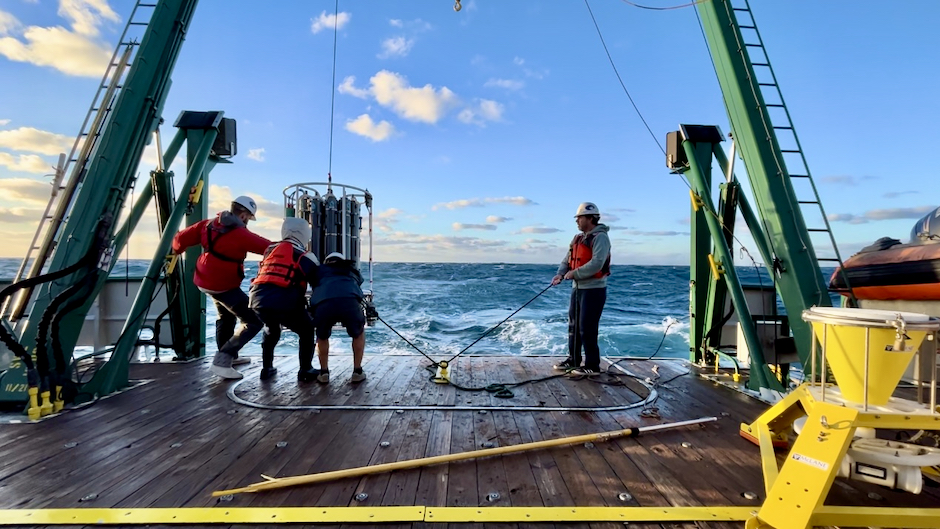
Photo: Tyler Christian, Cooperative Institute for Marine and Atmospheric Studies:
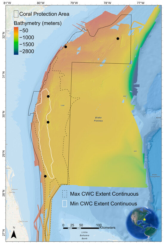
From NOAA - Multi-partner mapping effort reveals largest known deep-sea coral reef habitat...
Covering 6.4 million acres, an area larger than Vermont, an underwater seascape of cold-water coral mounds off the shore of the southeast United States coast has been deemed the largest deep-sea coral reef habitat discovered to date, according to a paper recently published in the scientific journal Geomatics.
“This strategic multiyear and multi-agency effort to systematically map and characterize the stunning coral ecosystem right on the doorstep of the U.S. East Coast is a perfect example of what we can accomplish when we pool resources and focus on exploring the approximately 50% of U.S. marine waters that are still unmapped,” says Derek Sowers, Ph.D., Mapping Operations Manager for the Ocean Exploration Trust and lead author of the study. “Approximately 75% of the global ocean is still unmapped in any kind of detail, but many organizations are working to change that. This study provides a methodology aimed at interpreting mapping data over large ocean regions for insights into seafloor habitats and advancing standardized approaches to classifying them to support ecosystem-based management and conservation efforts.”
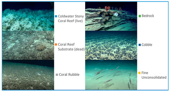
For the study, “Mapping and Geomorphic Characterization of the Vast Cold-Water Coral Mounds of the Blake Plateau,” scientists synthesized bathymetric data from 31 multibeam sonar mapping surveys, the largest of which were led by NOAA Ocean Exploration, to produce a nearly complete map of the seafloor of the Blake Plateau, located about 100 miles off the southeast U.S. coastline.
The study area that includes the coral reef is nearly the size of Florida. It is approximately 35-75 miles (60–120 km) offshore of the southeast coast beginning off Miami and stretching to the area offshore of Charleston, South Carolina. The authors used a standardized system developed as part of the study to classify, delineate and quantify coral mound features. This automated system identified 83,908 individual coral mound peak features in the mapping data, providing the first estimate of the overall number of potential cold-water coral mounds mapped in the region to date.
The study documents the massive scale of the coral province, an area composed of nearly continuous coral mound features that span up to 500 kilometers (310 miles) long and 110 kilometers (68 miles) wide, with a core area of high-density mounds up to 254 kilometers (158 miles) long and 42 kilometers (26 miles) wide. The results also highlight how different regions of the Blake Plateau exhibit large variations in the density, height and pattern of coral mound formation.
Data analyzed, which included imagery from 23 submersible dives in addition to mapping data, were collected as part of a coordinated, multi-year ocean exploration campaign involving NOAA Ocean Exploration, NOAA Ocean Exploration Cooperative Institute partners Ocean Exploration Trust and the University of New Hampshire, the Bureau of Ocean Energy Management, Temple University, and the U.S. Geological Survey, with contributions from Fugro, the NOAA Deep Sea Coral Research and Technology Program, and the South Atlantic Fishery Management Council.
The largest area, nicknamed “Million Mounds” by scientists, is primarily made up of Desmophyllum pertusum (previously called Lophelia pertusa), a stony coral most commonly found at depths between 200 - 1,000 meters (656 - 3,280 feet), where waters have an average temperature of 4°C (39°F). Cold-water corals such as these grow in the deep ocean where there is no sunlight and survive by filter-feeding biological particles. While they are known to be important ecosystem engineers, creating structures that provide shelter, food and nursery habitat to other invertebrates and fish, these corals remain poorly understood.
Studies such as this one provide a better understanding of how populations of corals and other deep-sea species may be related across geographically separated locales (a concept known as connectivity) which in turn can offer insight into the resiliency of these populations. This is important for predicting the impacts of human activities on coral communities and for developing plans for their protection.
“For years we thought much of the Blake Plateau was sparsely inhabited, soft sediment, but after more than 10 years of systematic mapping and exploration, we have revealed one of the largest deep-sea coral reef habitats found to date anywhere in the world,” said Kasey Cantwell, operations chief for NOAA Ocean Exploration. “Past studies have highlighted some coral in the region, particularly closer to the coast and in shallower waters, but until we had a complete map of the region, we didn’t know how extensive this habitat was, nor how many of these coral mounds were connected. This discovery highlights the importance of exploring our deepwater backyard and the power of interagency collaboration and public-private partnerships.”
:quality(70)/d1hfln2sfez66z.cloudfront.net/10-30-2024/t_96f5c4f8145b481cbd3b05c492b5e5c2_name_file_960x540_1200_v3_1_.jpg)
:quality(70)/cloudfront-us-east-1.images.arcpublishing.com/cmg/OA5VFVKXALI3DDBN7YA7WH6CTE.jpg)
:quality(70)/d1hfln2sfez66z.cloudfront.net/10-31-2024/t_0bbe782cd9484b4280d318d45d1455ea_name_file_960x540_1200_v3_1_.jpg)
:quality(70)/d1hfln2sfez66z.cloudfront.net/10-31-2024/t_62a37f939b3546eda3668cefb692ca57_name_file_960x540_1200_v3_1_.jpg)
:quality(70)/d1hfln2sfez66z.cloudfront.net/10-31-2024/t_30738ca7778542b58ab909b092fa88de_name_file_960x540_1200_v3_1_.jpg)