
Sept. 2, 2017 — Hurricane "Irma" over moving into Central Atlantic ... several other areas to watch.......
The "Buresh Bottom Line" is: stay tuned!... Always be prepared!..... City of Jacksonville Preparedness Guide... Georgia Hurricane Guide.
As we head into the peak of the Cabo (Cape) Verde season, waves are streaming west off Africa. "Irma" was one such wave & is turning into a classic deep tropics long track (trans-Atlantic) hurricane intensifying from a tropical storm early Thu. to a Cat. 3 by late afternoon. Some dry air, shear, slightly cooler water temps. & changes in structure (eyewall replacement cycles) from time to time should lead to "Irma" holding steady state or even weakening a bit before moving into a very favorable environment for intensification over the Central Atlantic.
I cannot emphasize enough that it's too early - & would be premature & irresponsible - to determine exactly where Irma is going to go in the long run &, therefore, whether or not there will be direct landfall on any part of the U.S. I do believe this is more of an east coast "issue" vs. Gulf, & I'm leaning east of Jacksonville. Most likely closest approach to any of Fl. would be very late next week or more likely over the weekend. Stay cool, calm & collected... NOW is the time to prepare if for no other reason:
(1) peak of the hurricane season is upon us
(2) you'll be prepared for anything mother nature throws at us - hurricane, lightning, flooding, tornado, etc. Preparations do not need to take a long time nor do preparations need to be expensive.
(3) know your evacuation zone
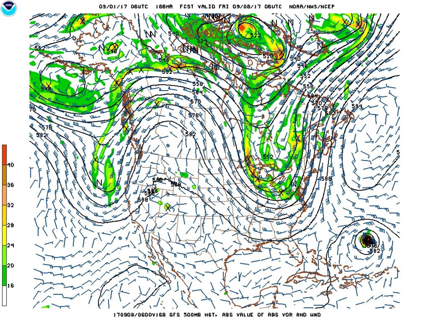
As would be expected at this early juncture, forecast models are all over the place - especially with regards to location in the long run. It would be prudent to not hang on each & every individual model run but rather look at the bigger picture in the coming days. There are some long range global forecast models that take Irma well into the W. Atlantic by the middle of next week - close to the NE Caribbean Islands including Puerto Rico while other models show a more northward turn earlier. I can say this potential storm will stay away from the U.S. & any land areas through Labor Day. Any building/movement &/or strengthening of the Bermuda High - which has been a strong mainstay for months - makes storm recurvature more difficult. Ultimately much of how this all unfolds hinges on a rather deep upper level trough that moves into the Central/Eastern U.S. next week which will play a pivotal role in the eventual movement of "Irma". The GFS model upper level (500 mb) chart below for Fri., 09/08 shows the strong trough. There is a clear alleway over the far W. Atlantic which could lead to an ucomfortably close to the U.S. powerful hurricane but that's mainly tracking a little to the east. The European model is farther north & east than it has been most of the past week but is noticeably farther south & west + slower than the GFS. Both have intitialized their data pretty well it would appear, so it's the long term solving of steering currents that is likely causing the track differences at the moment.
STILL VERY EARLY on how the steering currents will play out by next weekend as "Irma" makes its move W/NW then more northward. Global models as a whole have recently trended north & east which is a good thing BUT could just as well swing back the other way at just about any time. A combination of plots from each model's run (ensemble) points to east of Florida next weekend.
I am also keeping a watchful eye on the Western Gulf of Mexico (yet again!) as indications - though forecast models have generally backed off for now - are that low pressure will try to develop over the Western Gulf next week. Whether or not this becomes a tropical system, the pattern could produce more heavy rain for parts of the Gulf Coast - thinking the middle & end of next week.
There are also hints of an overall lowering of pressures over the Caribbean which could be a spot to watch in the long range. The Caribbean is a "favorite" for tropical cyclone genesis from mid through late season.
And another strong tropical wave has come off the coast of Africa with the potential for mid to long range development....


"Irma" model plots have trended north & east....

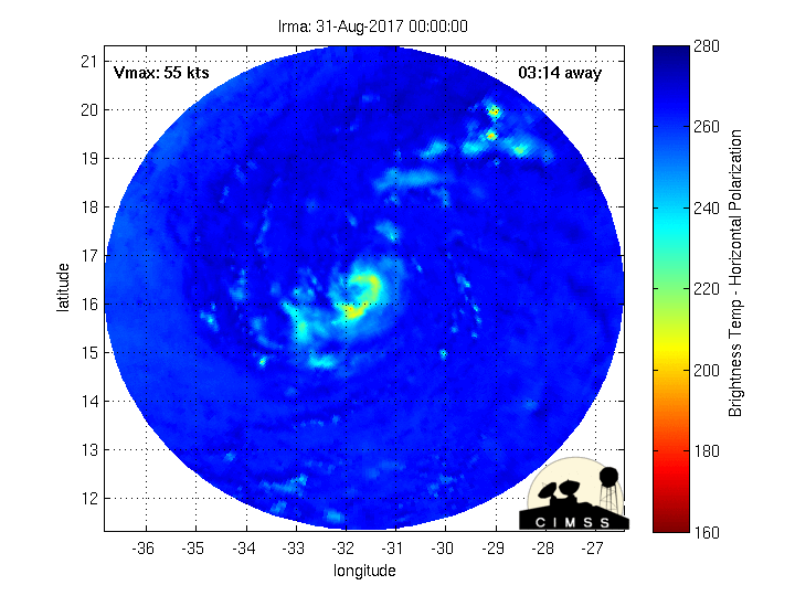
Fascinating imagery(!) from CIMMS, University of Wisconsin, Madison - Microwave radar-simulated imagery... click here for full definition..... as "Irma" rapidly tightens up then weakens....

And let's dust off our Pacific typhoon teleconnection for trying to forecast "Irma" - it's not quite exactly lined up yet but is becoming close enough to possibly draw some parallels. The 500mb chart below from the GFS for the N. Pacific to the Northern U.S. shows trough, ridge, trough, ridge, trough - the last trough being over or near the Eastern U.S. (it's what's picking up the "Harvey" remnants). The W. Pacific trough is picking up typhoon "Sanvu" keeping the tropical cyclone very near or to the immediate east of Japan with a recurve into the N. Pacific. This MIGHT be an early clue that at least some semblance of troughing will remain in place over or near the Eastern U.S. which COULD become a protector of sorts for the U.S. east coast -- or at least Florida -- through next weekend.

Satellite imagery below shows a strong ocean storm over the NW Atlantic which which is helping to soften the western Bermuda ridge for the time being. The question becomes how long will it be before the ridge tries to build back to the west. Plus strong convection noted over the W. Caribbean....

Tropical cyclone formation probability over next 1 - 2 days:
0
1
Wind shear analysis (red is stronger shear). Shear will be rather strong for a couple of days near "Irma" before the shear relaxes much of next week....

Water vapor imagery shows quite a bit of dry air in the vicinity of "Irma" for the moment:

Imagery below courtesy CIMMS shows African Saharan dust (orange & red)....
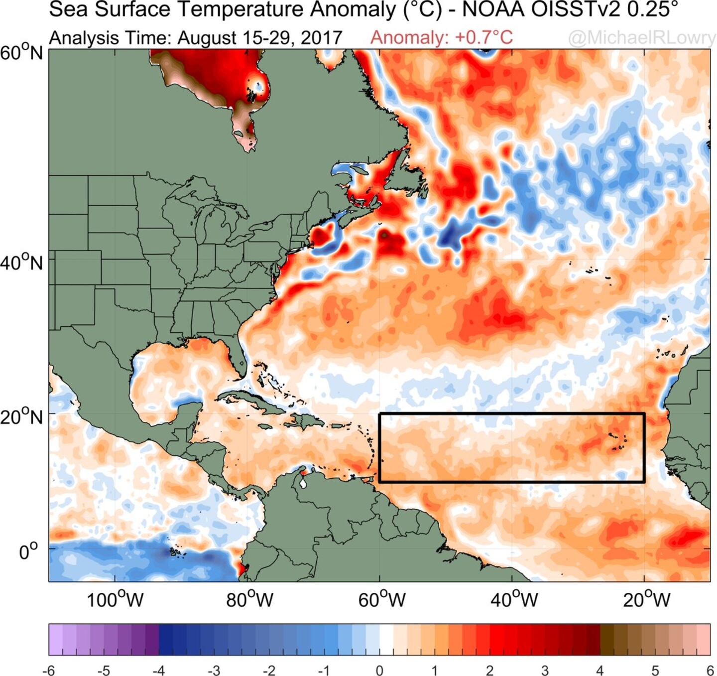
The main development region (MDR) shows above avg. temps. - in fact - only 2005 & 2010 were warmer. The deep warm ocean water can "energize" tropical cyclones:
SE U.S. surface map:


Surface analysis centered on the tropical Atlantic:

Surface analysis of the Gulf:

Caribbean:
0
The Eastern Pacific has an active storm too. "Lidia" hammered the Baja of California with flooding rains, strong winds & rough surf. Some of this tropical moisture may eventually make it into the SW U.S. - S. California & Arizona - over the next few days.
1
2
Dr. Phil Klotzbach provides the genesis points for September named storms:
3
NOAA:
4
Cox Media Group


