
Oct. 12, 2017 — Photos: Must-see photos of Irma damage in Jacksonville area .... hurricane Irma recap
Ophelia" over the far NE Atlantic....
The "Buresh Bottom Line": Always be prepared!..... City of Jacksonville Preparedness Guide... Georgia Hurricane Guide.
A weak surface trough mixed with an old tropical wave is moving west across the Bahamas. Movement will continue to be to the west with no significant surface development.
A strong tropical wave is far to the east of the Lesser Antilles but will likely struggle to move very far to the west in the end.


"Ophelia" went hurricane Wed. afternoon over the Northeast Atlantic. The storm will slowly move east before turning northeast & accelerating toward the weekend. Though no longer tropical, the storm is expected to lash Great Britain & Ireland next Tue. & Wed. as a big ocean - extra-tropical - storm with strong winds.


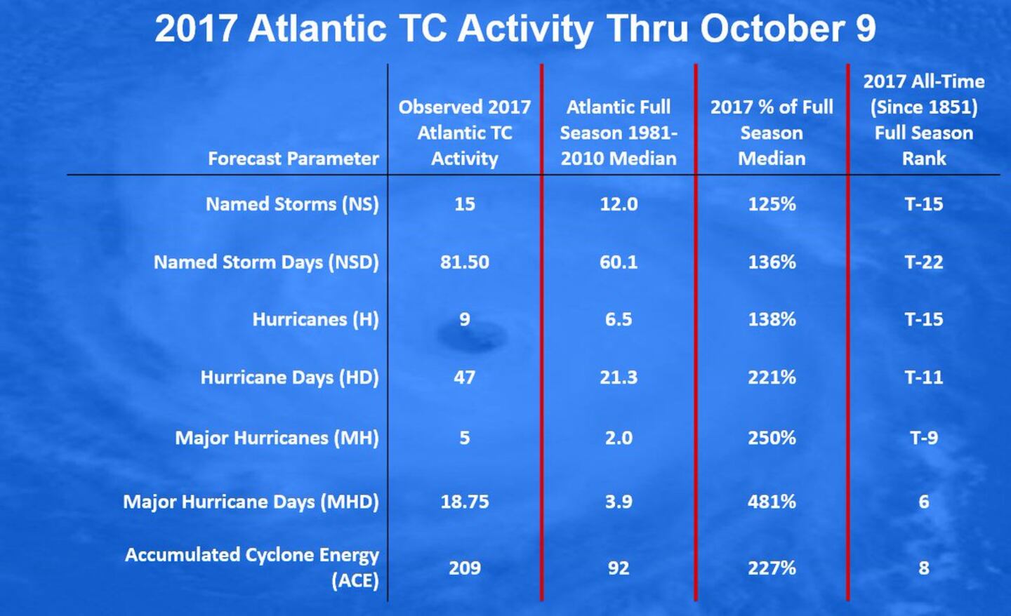
The chart below is courtesy Phil Klotzbach, CSU hurricane researcher & illustrates the active season we've had in '17 (though there have been more active ones!):
Interesting map below tweeted by Erik Pindrock shows virtually all of Fl. has experienced at least tropical storm force winds this year... as well as the entire Gulf Coast... & as far north as N. Carolina on the east coast:

Deep oceanic heat content is still very evident - especially over the Caribbean & Gulf:

Sea surface temp. anomalies over/near the Gulf / Fl./ SW Atlantic:

East Atlantic IR satellite:
0
Mid & upper level wind shear (enemy of tropical cyclones) analysis (CIMMS).
1
SE U.S. surface map:


Surface analysis centered on the tropical Atlantic:

Surface analysis of the Gulf:

Caribbean:

Extensive hurricane Irma recap - click here.

One year ago this week - hurricane Matthew made its closest approach to Jacksonville - here.
Cox Media Group


