:quality(70)/cloudfront-us-east-1.images.arcpublishing.com/cmg/KSK2GJATWZDXFCRSQK22CE442U.png)
Jacksonville, Fl. — The “Buresh Bottom Line”: Always be prepared!.....First Alert Hurricane Preparation Guide... City of Jacksonville Preparedness Guide... Georgia Hurricane Guide.
STAY INFORMED: Get the * FREE * First Alert Weather app
FREE NEWS UPDATES, ALERTS: Action News Jax app for Apple | For Android
WATCH “Preparing for the Storm”
WATCH “The Ins & Outs of Hurricane Season”
READ the First Alert Hurricane Center “Survival Guide”
LISTEN & WATCH “Surviving the Storm” - WOKV Radio & Action News Jax
***** ALWAYS CHECK & RE-CHECK THE LATEST FORECAST & UPDATES! *****
REMEMBER WHEN A TROPICAL STORM OR HURRICANE IS APPROACHING: Taping windows is *not* recommended & will not keep glass from breaking. Instead close curtains & blinds.
Realize the forecast cone (”cone of uncertainty”) is the average forecast error over a given time - out to 5 days - & *does not* indicate the width of the storm &/or where damage that might occur.

*Chief Meteorologist Mike Buresh is scheduled to take back over “Talking the Tropics” on Wednesday. Welcome back, Mike!*
I am still monitoring multiple tropical waves emerging from the West Coast of Africa. The thing is, the environment north of 10º North latitude isn’t too good for the development of tropical cyclones. The weather pattern over the Atlantic appears to get a bit “better” over the second half of August.
We should also remember that just because a tropical wave doesn’t develop out in the deep tropical Atlantic, doesn’t mean it can’t sniff out a spot to develop farther to the west.
Warm water... The Atlantic remains very warm. In fact, record warm. But, despite blaring headlines -- it goes to show you, a tropical wave needs more than just really warm water to develop. Other aspects of the atmosphere have to line up as well. As mentioned above, it appears the atmosphere gets more “in line” for the second half of the month over the open waters of the Atlantic.

Hurricane Dora... no, not the one from 1964 in the Atlantic. This time, it’s the Pacific. Hurricane Dora continues to be quite the “beauty” over the open waters. Dora will continue to pass harmlessly well south of Hawaii today.


Water vapor loop (dark blue/yellow is dry mid & upper level air):


July tropical cyclone origins:
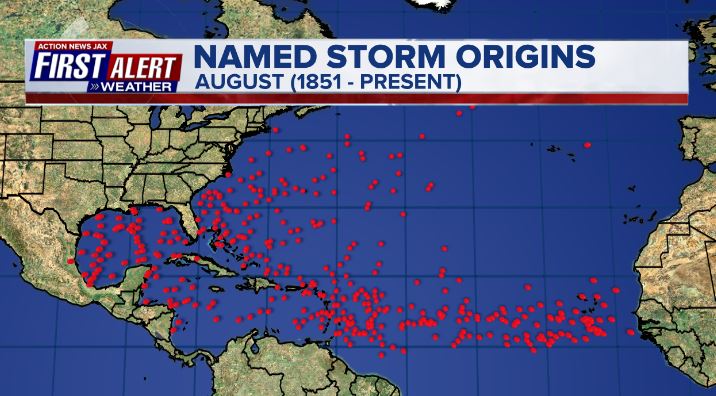
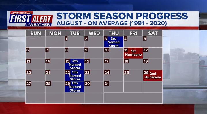
Averages below based on climatology for the Atlantic Basin for August:

Wind shear:


Saharan dust spreads west each year from Africa by the prevailing winds (from east to west over the Atlantic). Dry air - yellow/orange/red/pink. Widespread dust is indicative of dry air that can impede the development of tropical cyclones. However, sometimes “wanna’ be” waves will just wait until they get to the other side of - or away from - the plume then try to develop if other conditions are favorable. In my personal opinion, way too much is made about the presence of Saharan dust & how it relates to tropical cyclones. In any case, the peak of Saharan dust typically is in June & July.

2023 names..... “Emily” is the next name on the Atlantic list (names are picked at random by the World Meteorological Organization... repeat every 6 years). Historic storms are retired [Florence & Michael in ’18... Dorian in ’19 & Laura, Eta & Iota in ‘20, Ida in ‘21 & Fiona & Ian in ‘22]). In fact, this year’s list of names is rather infamous with “Katrina”, “Rita” & “Wilma” retired from the ‘05 list & “Harvey”, “Irma”,“Maria” & “Nate” from the ‘17 list. The WMO decided - beginning in 2021 - that the Greek alphabet will be no longer used & instead there will be a supplemental list of names if the first list is exhausted (has only happened three times - 2005, 2020 & 2021). The naming of tropical cyclones began on a consistent basis in 1953. More on the history of naming tropical cyclones * here *.


East Atlantic:


Mid & upper level wind shear (enemy of tropical cyclones) analysis (CIMMS). The red lines indicate strong shear:

Water vapor imagery (dark blue indicates dry air):

Deep oceanic heat content over the Gulf, Caribbean & deep tropical Atlantic. The brighter colors will expand rather dramatically by Aug./Sept./Oct.:

Sea surface temp. anomalies:


SE U.S. surface map:

Surface analysis centered on the tropical Atlantic:

Surface analysis of the Gulf:

Caribbean:

GFS wave forecast at 48 & 72 hours (2 & 3 days):


Atlantic Basin wave period forecast for 24, 48 & 72 hours respectively:


East/Central Pacific:


West Pacific:

Global tropical activity:

“Doksuri” is near the extreme Northern Philippines & will make a China landfall by late week:


Cox Media Group
:quality(70)/d1hfln2sfez66z.cloudfront.net/10-30-2024/t_96f5c4f8145b481cbd3b05c492b5e5c2_name_file_960x540_1200_v3_1_.jpg)
:quality(70)/d1hfln2sfez66z.cloudfront.net/10-31-2024/t_62a37f939b3546eda3668cefb692ca57_name_file_960x540_1200_v3_1_.jpg)
:quality(70)/cloudfront-us-east-1.images.arcpublishing.com/cmg/OA5VFVKXALI3DDBN7YA7WH6CTE.jpg)
:quality(70)/d1hfln2sfez66z.cloudfront.net/10-31-2024/t_0bbe782cd9484b4280d318d45d1455ea_name_file_960x540_1200_v3_1_.jpg)
:quality(70)/d1hfln2sfez66z.cloudfront.net/10-31-2024/t_57d89e06d1dc421c87dbed7b4cb61862_name_file_960x540_1200_v3_1_.jpg)