:quality(70)/cloudfront-us-east-1.images.arcpublishing.com/cmg/KSK2GJATWZDXFCRSQK22CE442U.png)
Jacksonville, Fl. — The “Buresh Bottom Line”: Always be prepared!.....First Alert Hurricane Preparation Guide... City of Jacksonville Preparedness Guide... Georgia Hurricane Guide.
STAY INFORMED: Get the * FREE * First Alert Weather app
FREE NEWS UPDATES, ALERTS: Action News Jax app for Apple | For Android
WATCH “Preparing for the Storm”
WATCH “The Ins & Outs of Hurricane Season”
READ the First Alert Hurricane Center “Survival Guide”
LISTEN & WATCH “Surviving the Storm” - WOKV Radio & Action News Jax
***** ALWAYS CHECK & RE-CHECK THE LATEST FORECAST & UPDATES! *****
REMEMBER WHEN A TROPICAL STORM OR HURRICANE IS APPROACHING: Taping windows is *not* recommended & will not keep glass from breaking. Instead close curtains & blinds.
Realize the forecast cone (”cone of uncertainty”) is the average forecast error over a given time - out to 5 days - & *does not* indicate the width of the storm &/or where damage that might occur.

Welcome to August! 121 days until the end of the Atlantic hurricane season (November 30). :) We are beginning our climb up the climatological mountain, so to speak. Typically, NE Florida and SE Georgia have to get to about mid-October before the tropical threat begins to really decrease.
:quality(70)/cloudfront-us-east-1.images.arcpublishing.com/cmg/ITSULKXT5JHUBEJTTZZUOS3CCE.png)
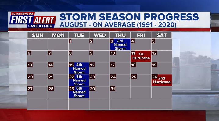
July brought us Hurricane “Don” in the Northern Atlantic. On Average, the first Atlantic hurricane forms on August 11th.
Central Atlantic... A tropical wave, “96-L,” continues to move north/northwest in the Central Atlantic. Showers and storms continue to be displaced to the east of the “center” of the area of low pressure. This is due to 30-40 knots of wind shear blowing the storms to the east. There is also just a bit of dry air on the west side of 96-L. It appears to increasingly look like this wave will not develop. The window of opportunity seems to be closing. The model data isn’t as enthusiastic with 96-L anymore either. At any rate, we don’t have to worry about this one. It will remain out to sea. The next name on the hurricane season list is “Emily.”


Water vapor loop (dark blue/yellow is dry mid & upper level air):


July tropical cyclone origins:
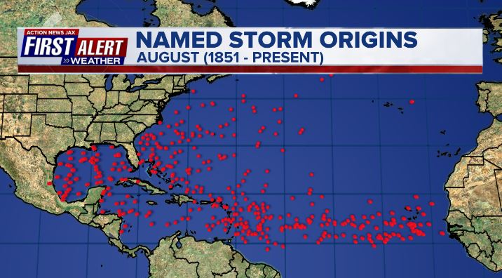
Averages below based on climatology for the Atlantic Basin for August:

Wind shear:


Saharan dust spreads west each year from Africa by the prevailing winds (from east to west over the Atlantic). Dry air - yellow/orange/red/pink. Widespread dust is indicative of dry air that can impede the development of tropical cyclones. However, sometimes “wanna’ be” waves will just wait until they get to the other side of - or away from - the plume then try to develop if other conditions are favorable. In my personal opinion, way too much is made about the presence of Saharan dust & how it relates to tropical cyclones. In any case, the peak of Saharan dust typically is in June & July.

2023 names..... “Emily” is the next name on the Atlantic list (names are picked at random by the World Meteorological Organization... repeat every 6 years). Historic storms are retired [Florence & Michael in ’18... Dorian in ’19 & Laura, Eta & Iota in ‘20, Ida in ‘21 & Fiona & Ian in ‘22]). In fact, this year’s list of names is rather infamous with “Katrina”, “Rita” & “Wilma” retired from the ‘05 list & “Harvey”, “Irma”,“Maria” & “Nate” from the ‘17 list. The WMO decided - beginning in 2021 - that the Greek alphabet will be no longer used & instead there will be a supplemental list of names if the first list is exhausted (has only happened three times - 2005, 2020 & 2021). The naming of tropical cyclones began on a consistent basis in 1953. More on the history of naming tropical cyclones * here *.


East Atlantic:


Mid & upper level wind shear (enemy of tropical cyclones) analysis (CIMMS). The red lines indicate strong shear:

Water vapor imagery (dark blue indicates dry air):

Deep oceanic heat content over the Gulf, Caribbean & deep tropical Atlantic. The brighter colors will expand rather dramatically by Aug./Sept./Oct.:

Sea surface temp. anomalies:


SE U.S. surface map:

Surface analysis centered on the tropical Atlantic:

Surface analysis of the Gulf:

Caribbean:

GFS wave forecast at 48 & 72 hours (2 & 3 days):


Atlantic Basin wave period forecast for 24, 48 & 72 hours respectively:


East/Central Pacific:


West Pacific:

Global tropical activity:

“Doksuri” is near the extreme Northern Philippines & will make a China landfall by late week:


Cox Media Group
:quality(70)/d1hfln2sfez66z.cloudfront.net/10-30-2024/t_96f5c4f8145b481cbd3b05c492b5e5c2_name_file_960x540_1200_v3_1_.jpg)
:quality(70)/d1hfln2sfez66z.cloudfront.net/10-31-2024/t_62a37f939b3546eda3668cefb692ca57_name_file_960x540_1200_v3_1_.jpg)
:quality(70)/cloudfront-us-east-1.images.arcpublishing.com/cmg/OA5VFVKXALI3DDBN7YA7WH6CTE.jpg)
:quality(70)/d1hfln2sfez66z.cloudfront.net/10-31-2024/t_0bbe782cd9484b4280d318d45d1455ea_name_file_960x540_1200_v3_1_.jpg)
:quality(70)/d1hfln2sfez66z.cloudfront.net/10-31-2024/t_57d89e06d1dc421c87dbed7b4cb61862_name_file_960x540_1200_v3_1_.jpg)