:quality(70)/cloudfront-us-east-1.images.arcpublishing.com/cmg/JIFG55NSN5HKZK6LKEZ4C7UU5I.jpg)
Jacksonville, Fl. — The “Buresh Bottom Line”: Always be prepared!.....First Alert Hurricane Preparation Guide... City of Jacksonville Preparedness Guide... Georgia Hurricane Guide.
STAY INFORMED: Get the * FREE * First Alert Weather app
FREE NEWS UPDATES, ALERTS: Action News Jax app for Apple | For Android
WATCH “Preparing for the Storm”
WATCH “The Ins & Outs of Hurricane Season”
READ the First Alert Hurricane Center “Survival Guide”
LISTEN & WATCH “Surviving the Storm” - WOKV Radio & Action News Jax
***** ALWAYS CHECK & RE-CHECK THE LATEST FORECAST & UPDATES! *****
REMEMBER WHEN A TROPICAL STORM OR HURRICANE IS APPROACHING: Taping windows is *not* recommended & will not keep glass from breaking. Instead close curtains & blinds.
Realize the forecast cone (”cone of uncertainty”) is the average forecast error over a given time - out to 5 days - & *does not* indicate the width of the storm &/or where damage that might occur.

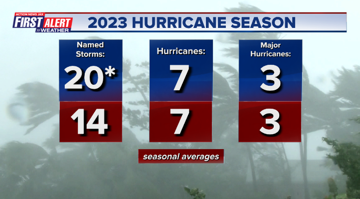
The Atlantic 2023 hurricane season was “active” if one measures in terms of numbers but intensity & landfalls were *for the most part* not as significant as one would expect for such an active season. A video recap:
:quality(70)/d1hfln2sfez66z.cloudfront.net/11-30-2023/t_35eb12534c99495f8a0c5dca2ca7dec9_name_file_1920x1080_1200_v3_1_.jpg)
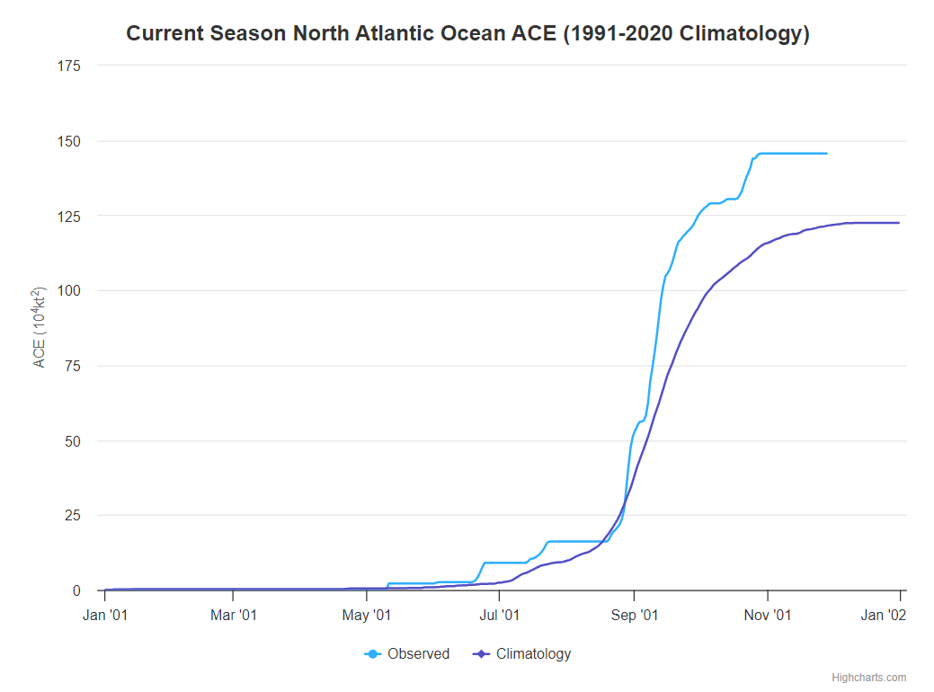
The ACE - accumulated cyclone energy which measures the strength & duration of tropical storms & hurricanes - did measure above avg. at 146 vs. the seasonal avg. of 123 or about 20% greater than the 30-year approximate average.
The high number of tropical storms was atypical - but not unexpected - considering a strengthening El Nino (warming of the equatorial Pacific). However, unseasonably warm sea surface temps. compensated some for the increased mid & upper level wind shear. Still... the majority of strong tropical cyclones stayed well out to sea with no landfalling systems in the Caribbean & only one landfalling hurricane for the U.S.

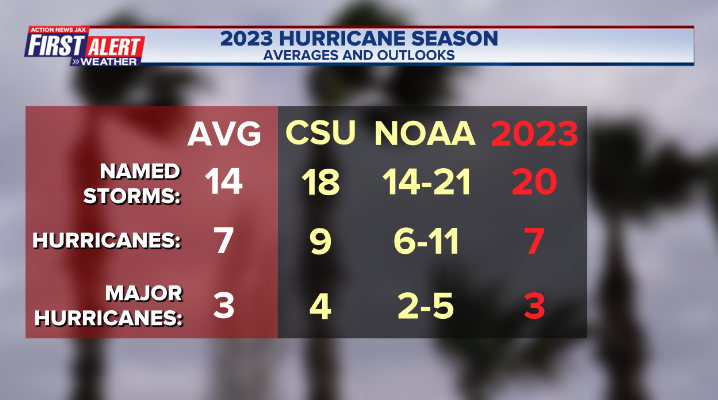
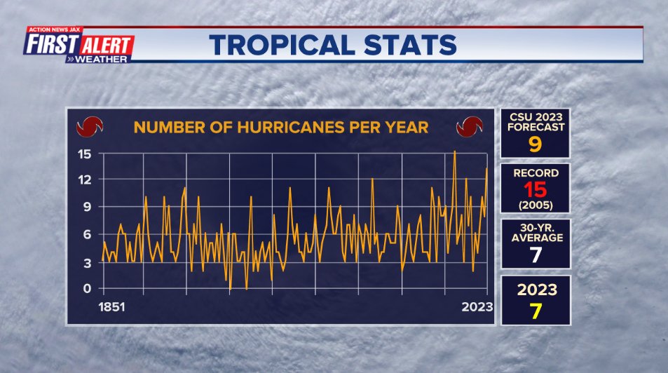
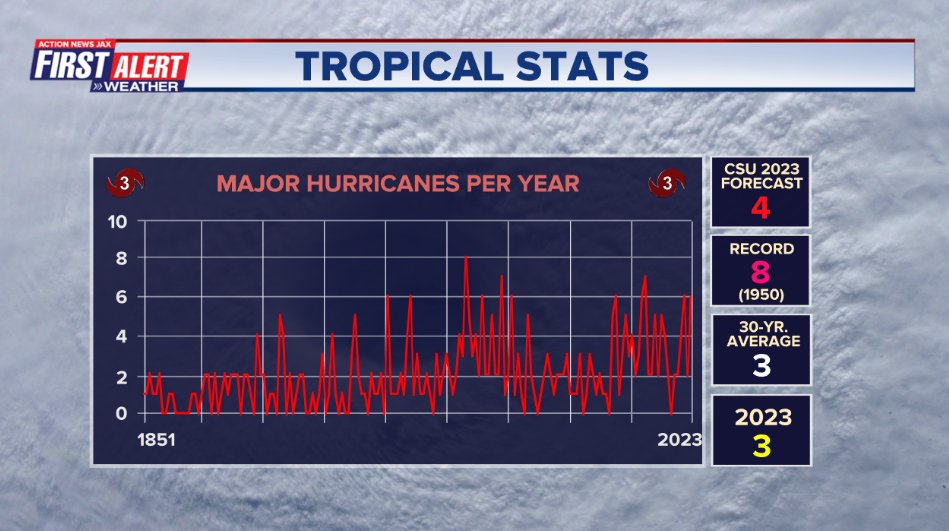
Seasonal forecasts by Colorado State University (Dr. Phil Klotzbach) & NOAA were generally in the “neighborhood” when it comes to pure numbers but were a little high on the number of hurricanes & “major” (Cat. 3+) hurricanes:
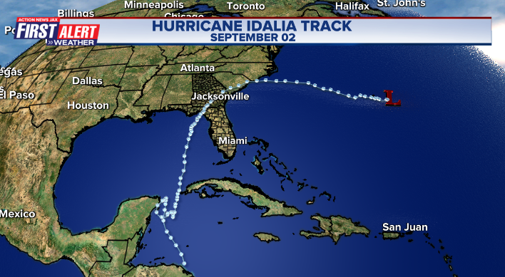
So the 2023 hurricane season will be remembered for Cat. 3 Idalia (Cat. 4 for a time over the Eastern Gulf of Mexico) making landfall in the Big Bend of Florida on Aug. 30th. The storm turned east/northeast once inland producing a swath of strong winds & heavy rain well inland over N. Central Fl. & much of Ga. A few tornadoes occurred in Glynn Co., Ga. about 40-50 miles north of Jacksonville. Power was out for as long as several days from Lake City, Fl. to Waycross, Ga. Impacts to Jacksonville & Duval Co. were minimal. For more on Idalia specifically, go to the “Buresh Blog” * here *.
:quality(70)/d1hfln2sfez66z.cloudfront.net/08-30-2023/t_e7d74b6d5cc5421689f6734c64b14ca0_name_file_960x540_1200_v3_1_.jpg)
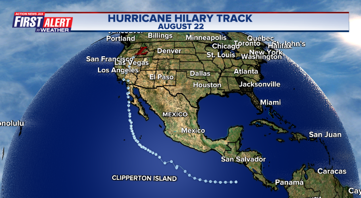
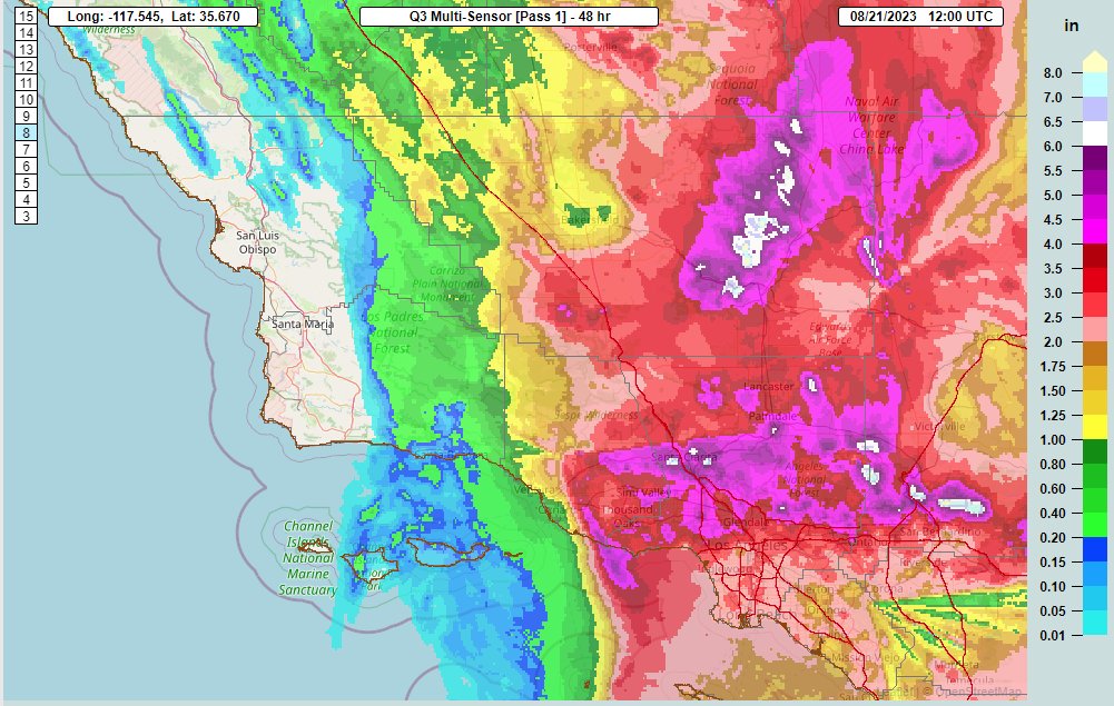
There were other notable tropical cyclones on the Pacific side. Hilary - though well off its peak - hit Southern California Aug. 20th with record rainfall including some desert areas resulting in up to 600% of their average August rainfall!
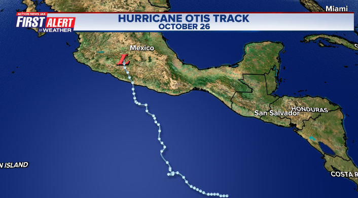
Then the “poster child” of the season was Cat. 5 Otis hammering Acapulco on Oct. 25th after rapidly intensifying just offshore. Otis was the most powerful hurricane to ever directly hit Acapulco & will result in years of rebuilding.
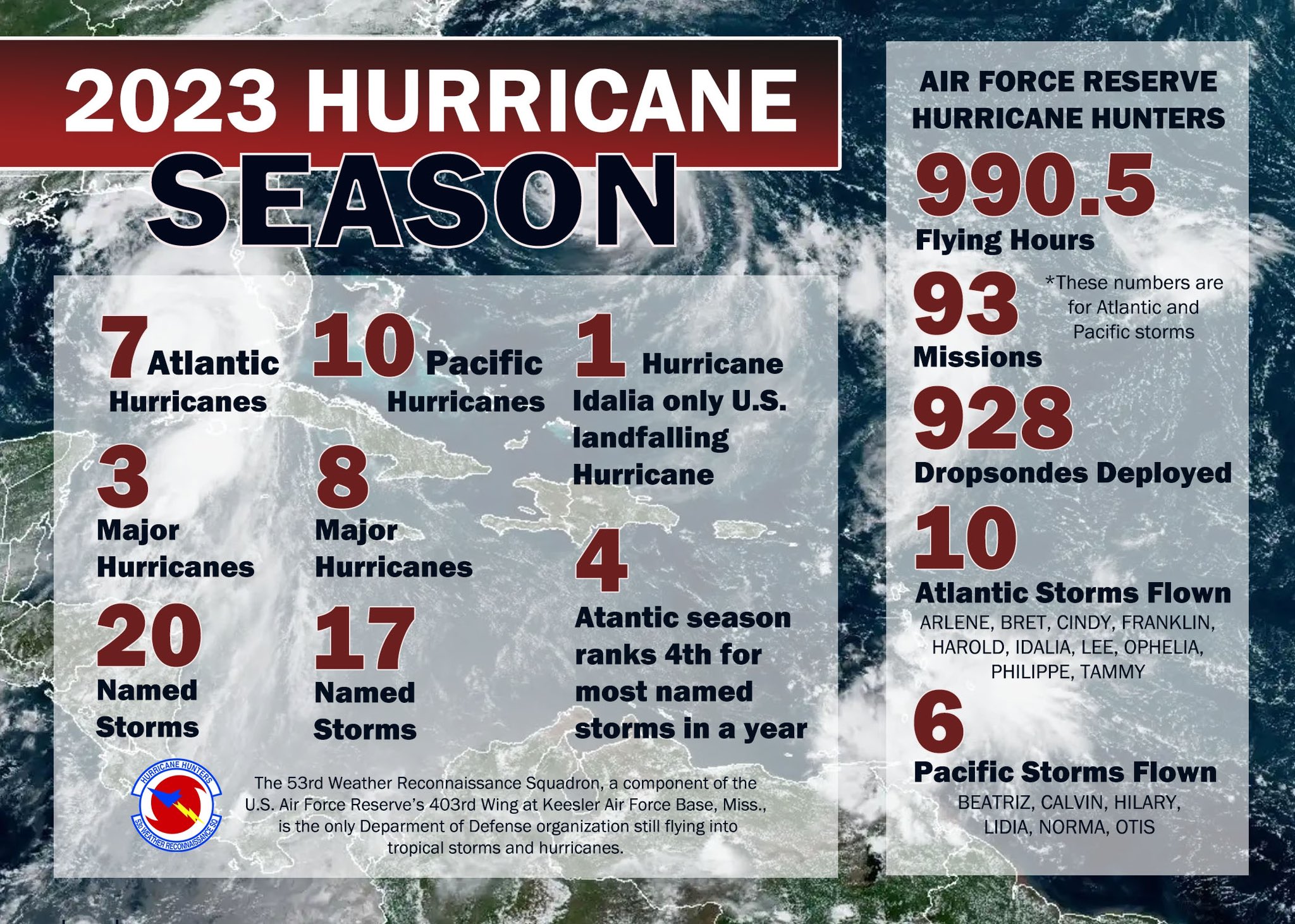
Hurricane hunter aircraft log for ‘23:
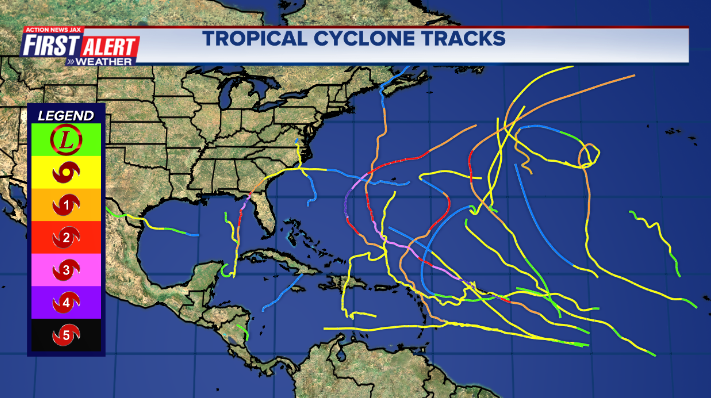
A month by month breakdown of the Atlantic hurricane season:
JUNE
1st - Tropical depression #2 (#1 as an unnamed subtropical storm over the N. Atlantic in January) forms over the NE Gulf of Mexico becoming tropical storm “Arlene” on the 2nd while moving S/SE then dissipated on the 3rd with no impacts to any land areas.
19th - Tropical depression #3 developed & became tropical storm “Brent” over the East Atlantic - the farthest east named storm for so early in the season.
22nd - Tropical depression #4 formed over the E. Atlantic & became tropical storm “Cindy”. It was the first June since 1968 with two named Atlantic storms & the earliest ever for two names storms so far east. The last Bret advisory was issued on the 24th... the last Cindy advisory on the 25th - both over the Central Atlantic.
JULY
14th - Subtropical storm “Don” forms over the Central Atlantic... becoming purely tropical on the 17th... strengthens to a hurricane on the 22nd before dissipating on the 24th.
AUGUST
19th - Tropical depression #6 forms over the Central Atlantic
20th - Tropical storm “Hilary” moves ashore on the southern coast of California from the Pacific producing very heavy rain, flooding & mudslides. Meanwhile - back on the Atlantic side - tropical storm “Franklin” formed over the Eastern Caribbean & tropical storm “Emily” formed over the E. Atlantic.
21st - Tropical depression #9 forms over the Western Gulf of Mexico... t.d. #6 becomes tropical storm “Gert” over the Central Atlantic then back to a tropical depression on the same day... & the last NHC advisory was issued on Emily.
22nd - Last NHC Gert advisory... tropical depression #9 becomes tropical storm “Harold” & moves into South Texas.
26th - Tropical depression #10 forms over the NW Caribbean becoming tropical storm “Idalia” the next day on the 27th.
28th - Franklin becomes a Cat. 3 hurricane over the open SW Atlantic
29th - Idalia goes hurricane over the Southeast Gulf... tropical depression #10 forms over the Central Atlantic.
30th - Cat. 3 Idalia (weakening from Cat. 4 hours earlier) makes landfall on the Fl. Big Bend at 7:50am.
31st - Idalia becomes post-tropical over the W. Atlantic... t.d. #11 strengthens into tropical storm “Jose” over the Central Atlantic.
SEPTEMBER
1st - Last NHC Franklin advisory over the NW Atlantic... Last Jose advisory over the W. Atlantic... tropical depression #12 forms over the E. Atlantic.
2nd - Last NHC Idalia advisory over the NW Atlantic... t.d. #12 becomes tropical storm “Katia” over the E. Atlantic
4th - Last NHC advisory on Katia over the E. Atlantic.
5th - Tropical depression #13 forms over the Central Atlantic & strengthens into tropical storm “Lee”.
6th - Lee strengthens into a hurricane over the Central Atlantic
7th - Tropical depression #14 forms over the E. Atlantic & becomes “Margot”.
11th - Margot strengthens into a hurricane over the E. Atlantic
15th - Tropical depression #15 forms over the Central Atlantic
16th - Lee becomes post-tropical before making landfall in Nova Scotia with 70 mph winds.
17th - Last NHC Lee advisory... last Margot advisory over the N. Atlantic... t.d. #15 becomes tropical storm “Nigel” over the Central Atlantic
18th - Nigel goes hurricane over the Central Atlantic
22nd - Last NHC advisory on Nigel over the N. Atlantic... Tropical storm “Ophelia” forms over the far W. Atlantic east of the Carolina’s.
23rd - Tropical storm Ophelia landfall on the N. Carolina coast then dissipates inland in the evening... tropical depression #17 forms & becomes tropical storm “Philippe” over the Central Atlantic.
28th - Tropical storm “Rina” forms over the Central Atlantic
OCTOBER
1st - Last NHC advisory over the Central Atlantic
6th - Last Philippe advisory over the NW Atlantic
10th - Tropical depression #19 forms over the E. Atlantic
11th - T.D. #19 strengthens into tropical storm “Sean” over the E. Atlantic with the last advisory issued on the 15th.
18th - Tropical storm “Tammy” forms over the Central Atlantic... becomes post-tropical on the 26th but back to tropical on the 27th... then dissipates on the 29th.
23rd - Tropical depression #21 forms over the Western Caribbean & moves inland over Central America the next day on the 24th.
25th - Cat. 5 hurricane “Otis” over the E. Pacific slams Acapulco, Mexico.
NOVEMBER
No Atlantic named storms.
A summary of 2023 Atlantic tropical cyclone records from Dr. Phil Klotzbach, Colorado State University:
• 20 named storms formed in the Atlantic this season. That is tied with 1933 for the 4th most on record, trailing 2020 (30 named storms), 2005 (28 named storms), and 2021 (21 named storms).
• 146 ACE was generated during 2023, making the 2023 Atlantic hurricane season an above-normal season by NOAA’s definition. The Atlantic has not had a below-average season per NOAA’s definition since 2015.
• 13 named storms formed in the Atlantic from August 20th through September 28th. That is the most on record between August 20 – September 28, breaking the old record of 12 named storm formations set in 2020.
• 5 hurricanes formed in the Atlantic between August 26 – September 18. This ties the record for most hurricane formations between August 26 – September 18, first set in 1955 and occurring in 2004 and 2012.
• Tropical Storms Bret and Cindy formed in the tropical Atlantic (south of 23.5°N, east of 60°W) in June. This is the first time on record that two named storms formed in the tropical Atlantic in June on record.
• Hurricanes Franklin and Idalia had max winds of 95 kt+ (109 mph) simultaneously – the first time that this occurred during August since 1950.
Individual Storm/Landfall Statistics
• Hurricane Franklin’s central pressure reached a lifetime maximum low of 926 hPa (27.34″) – the lowest central pressure for a hurricane that far north (29°N) in the open Atlantic on record.
• Hurricane Idalia made landfall with max winds of 110 kt (127 mph) – the strongest hurricane to make landfall in the Big Bend region of Florida since 1896.
• Hurricane Lee intensified by 70 kt (81 mph) in 24 hours. Six other Atlantic hurricanes in the satellite era (since 1966) have intensified by 70+ kt in 24 hours: Wilma (2005), Felix (2007), Ike (2008), Matthew (2016), Maria (2017) and Eta (2020).
• Tropical Storm Philippe was a named storm for 12.75 days but only reached a maximum intensity of 45 kt (52 mph). All other storms in the Atlantic lasting that long had a maximum intensity of at least 60 kt.
• Tropical Storm Sean formed at 33.1°W on October 10th – the farthest east that a named storm has formed in the tropical Atlantic (south of 23.5°N) this late in the calendar year on record.
• Tammy became a hurricane on October 20 - the latest calendar year hurricane on record in the tropical Atlantic (south of 20°N, east of 60°W)
TROPICAL ATLANTIC OUTLOOK:
The Atlantic Basin Overview:
No areas of concern...


The upper oceanic heat content (UOHC) [tropical cyclone heat potential/TCHP] across the SW Atlantic, Gulf & Caribbean:


Water vapor loop (dark blue/yellow is dry mid & upper level air):


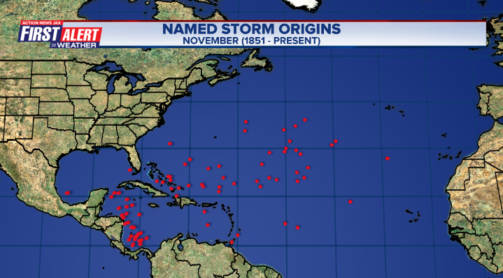
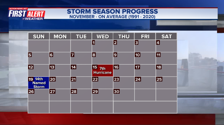
November tropical cyclone origins:
Averages below based on climatology for the Atlantic Basin for November (7 hurricanes so far, 19 tropical storms):
Wind shear:


Saharan dust spreads west each year from Africa by the prevailing winds (from east to west over the Atlantic). Dry air - yellow/orange/red/pink. Widespread dust is indicative of dry air that can impede the development of tropical cyclones. However, sometimes “wanna’ be” waves will just wait until they get to the other side of - or away from - the plume then try to develop if other conditions are favorable. In my personal opinion, way too much is made about the presence of Saharan dust & how it relates to tropical cyclones. In any case, the peak of Saharan dust typically is in June & July.

2023 names..... “Vince” is the next name on the Atlantic list (names are picked at random by the World Meteorological Organization... repeat every 6 years). Historic storms are retired [Florence & Michael in ’18... Dorian in ’19 & Laura, Eta & Iota in ‘20, Ida in ‘21 & Fiona & Ian in ‘22]). In fact, this year’s list of names is rather infamous with “Katrina”, “Rita” & “Wilma” retired from the ‘05 list & “Harvey”, “Irma”,“Maria” & “Nate” from the ‘17 list. The WMO decided - beginning in 2021 - that the Greek alphabet will be no longer used & instead there will be a supplemental list of names if the first list is exhausted (has only happened three times - 2005, 2020 & 2021). The naming of tropical cyclones began on a consistent basis in 1953. More on the history of naming tropical cyclones * here *.


East Atlantic:


Mid & upper level wind shear (enemy of tropical cyclones) analysis (CIMMS). The red lines indicate strong shear:

Water vapor imagery (dark blue indicates dry air):

Deep oceanic heat content over the Gulf, Caribbean & deep tropical Atlantic. The brighter colors are expanding dramatically as we near the peak of the hurricane season.:

Sea surface temp. anomalies:


SE U.S. surface map:

Surface analysis centered on the tropical Atlantic:

Surface analysis of the Gulf:

Caribbean:

Atlantic Basin wave period forecast for 24, 48, 72 & 96 hours respectively:


East/Central Pacific:


West Pacific:

Global tropical activity:


Cox Media Group
:quality(70)/cloudfront-us-east-1.images.arcpublishing.com/cmg/YNYHQR4LBVFI3OJGCFF32OEDVM.png)
:quality(70)/cloudfront-us-east-1.images.arcpublishing.com/cmg/HX2U3Y45JBCXXA7M6YH3A3B6AQ.jpg)
:quality(70)/cloudfront-us-east-1.images.arcpublishing.com/cmg/4IPZLYK5KNAV3MPRHJ5HBAKS5Q.jpeg)
:quality(70)/d1hfln2sfez66z.cloudfront.net/04-27-2024/t_a52b4340b0444d7ea55162aca9ac4b17_name_file_960x540_1200_v3_1_.jpg)
:quality(70)/cloudfront-us-east-1.images.arcpublishing.com/cmg/SPL6W4EORNAJDGIBFCNGGKDLLU.png)