
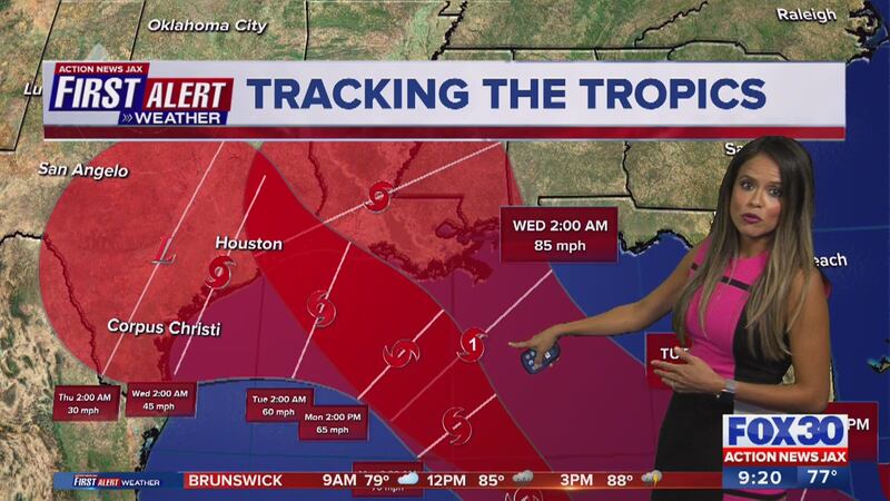
The First Alert Weather team is tracking Laura. The extremely dangerous storm continued to press inland through Louisiana Thursday after making landfall near 2 a.m. ET in the Cameron area. Laura made landfall as a category 4 hurricane with winds of 150 mph. It will continue moving north through Thursday as it weakens. Click here to watch LIVE updates on FOX30 & CBS47.
Latest updates below:
August 27
12 p.m. Update: Damaging winds and flooding rainfall are spreading inland over the northern portions of Louisiana, while high water levels persist along portions of the coast, the National Hurricane Center said.
Here is the 12 PM CDT 8/27 update for #Laura. Damaging winds and flooding rainfall are spreading inland over the northern portions of Louisiana, while high water levels persist along portions of the coast. More info: https://t.co/tW4KeGdBFb and https://t.co/SiZo8ozBbn pic.twitter.com/ItFrBLEELp
— National Hurricane Center (@NHC_Atlantic) August 27, 2020
11 a.m. Update: Laura is now a category 1 hurricane, according to latest advisory from the National Hurricane Center. Wind speeds are 75 mph in northern Louisiana.
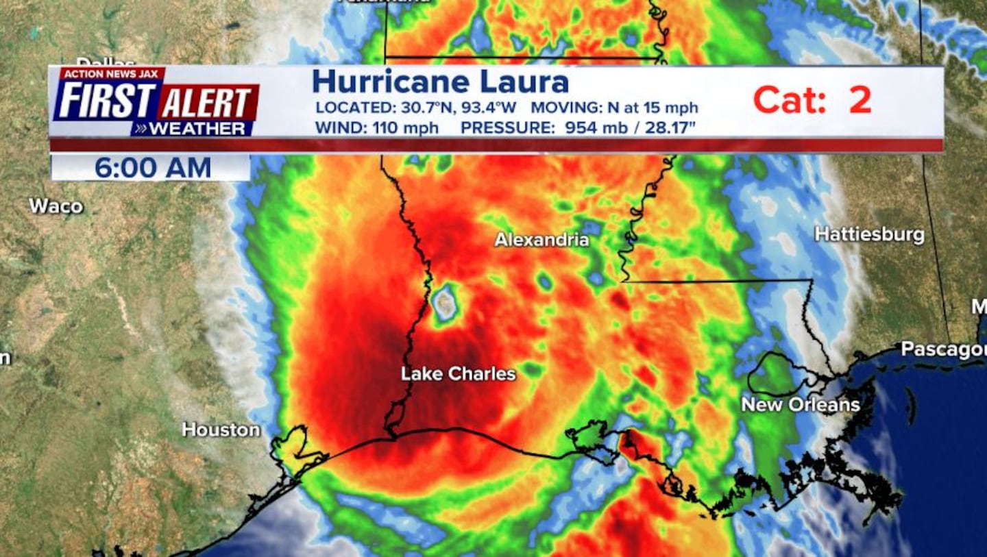
6 a.m. Update: Laura has weakened and is now a category 2 hurricane that’s moving north in Louisiana.
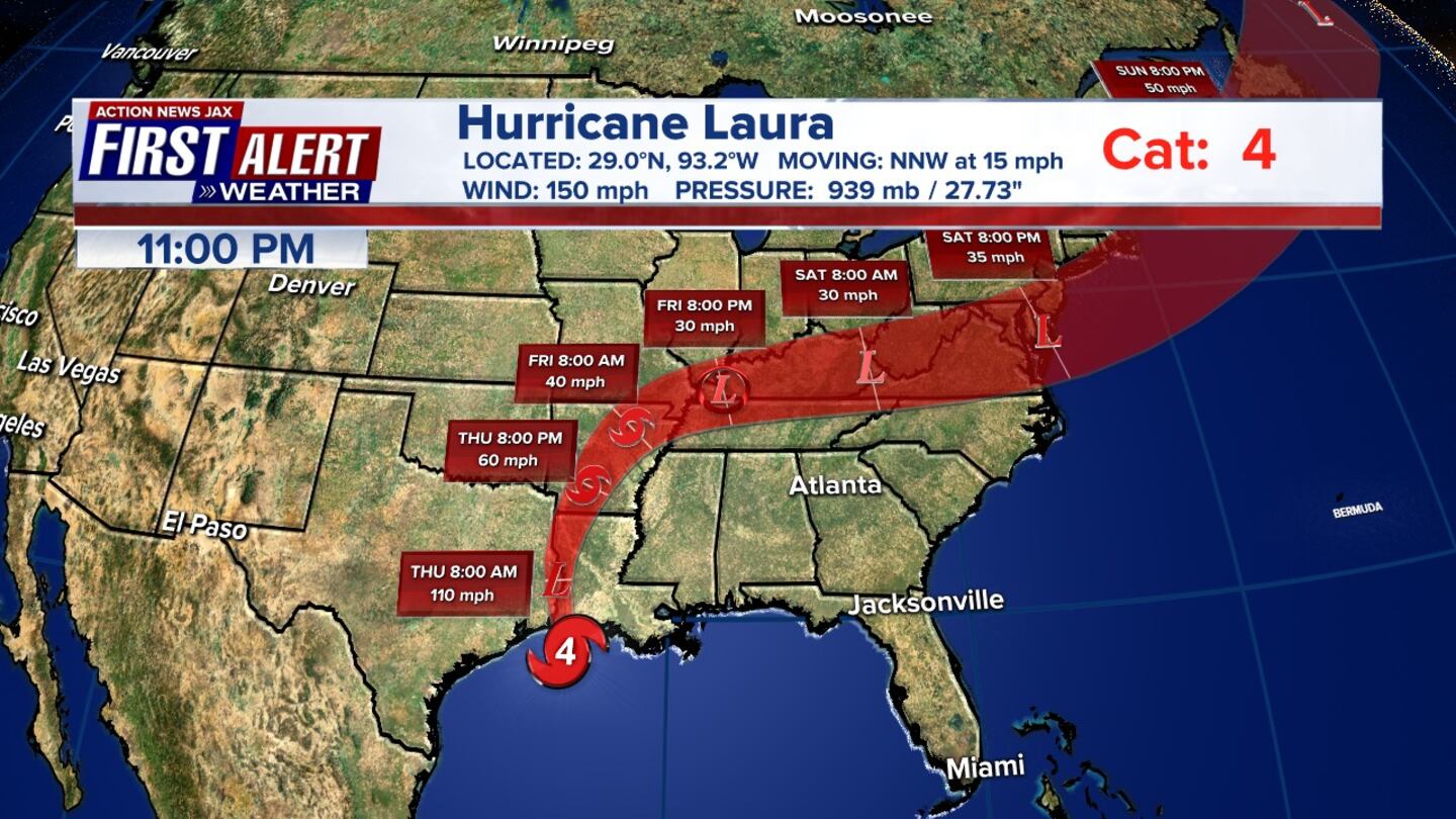
2 a.m. Update: Hurricane Laura officially made landfall about 1:50 a.m. EDT at Cameron, Louisiana as a preliminary category 4 storm with winds of 150 mph. The storm’s power has raised fears of a 20-foot (6-meter) storm surge that forecasters say would be “unsurvivable” and capable of sinking entire communities on the Texas and Louisiana coast.
#firstalertwx #HurricaneLaura landfall about 1:50am EDT at Cameron, Louisiana - preliminary Cat. 4 w/ winds of 150 mph @WOKVNews pic.twitter.com/X66kg4uKGF
— Mike Buresh (@MikeFirstAlert) August 27, 2020
August 26
11 p.m. Update:
Hurricane Laura is still a Category 4, moving NNW at 15 mph, with a wind speed of 150 mph threatening the Texas-Louisiana coast. Laura is forecasted to make landfall between 12:30 am and 1:30 am CDT.
#firstalertwx *11pm advisory Wed., 08/26* #HurricaneLaura @WOKVNews north eyewall looks to be ashore between 12:30 & 1:30am CDT pic.twitter.com/jVdP3r8tea
— Mike Buresh (@MikeFirstAlert) August 27, 2020
10 p.m. Update:
Quick First Alert Weather Update: Powerful hurricane Laura soon to make landfall on the SW coast of Louisiana... local rain chances go up by late week/weekend @wokvnews #FirstAlertWx pic.twitter.com/b1oK9TiKTv
— Mike Buresh (@MikeFirstAlert) August 27, 2020
8 p.m. Update:
FIRST ALERT WEATHERFIRST ALERT WEATHER Join First Alert Weather Chief Meteorologist Mike Buresh with this evening's interactive weather Facebook Live: All the weather all the time. Comment with any questions you have.
Posted by Action News Jax on Wednesday, August 26, 2020
#firstalertwx *8pm advisory update, Wed., 08/26* #Laura still(!) strengthening @wokvnews.... slight turn to the north (as expected) #FirstAlertWx pic.twitter.com/jQJOVULIyN
— Mike Buresh (@MikeFirstAlert) August 26, 2020
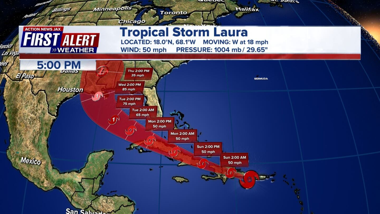
5 p.m. Update: According to Chief Meteorologist Mike Buresh, Hurricane Laura is still strengthening and expected to hit landfall near the Texas and Louisiana border overnight.
#firstalertwx *5pm advisory update, Wed., Aug. 26* - still strengthening... overnight landfall near Tx/La border @WOKVNews pic.twitter.com/oOI1Gzyu8B
— Mike Buresh (@MikeFirstAlert) August 26, 2020
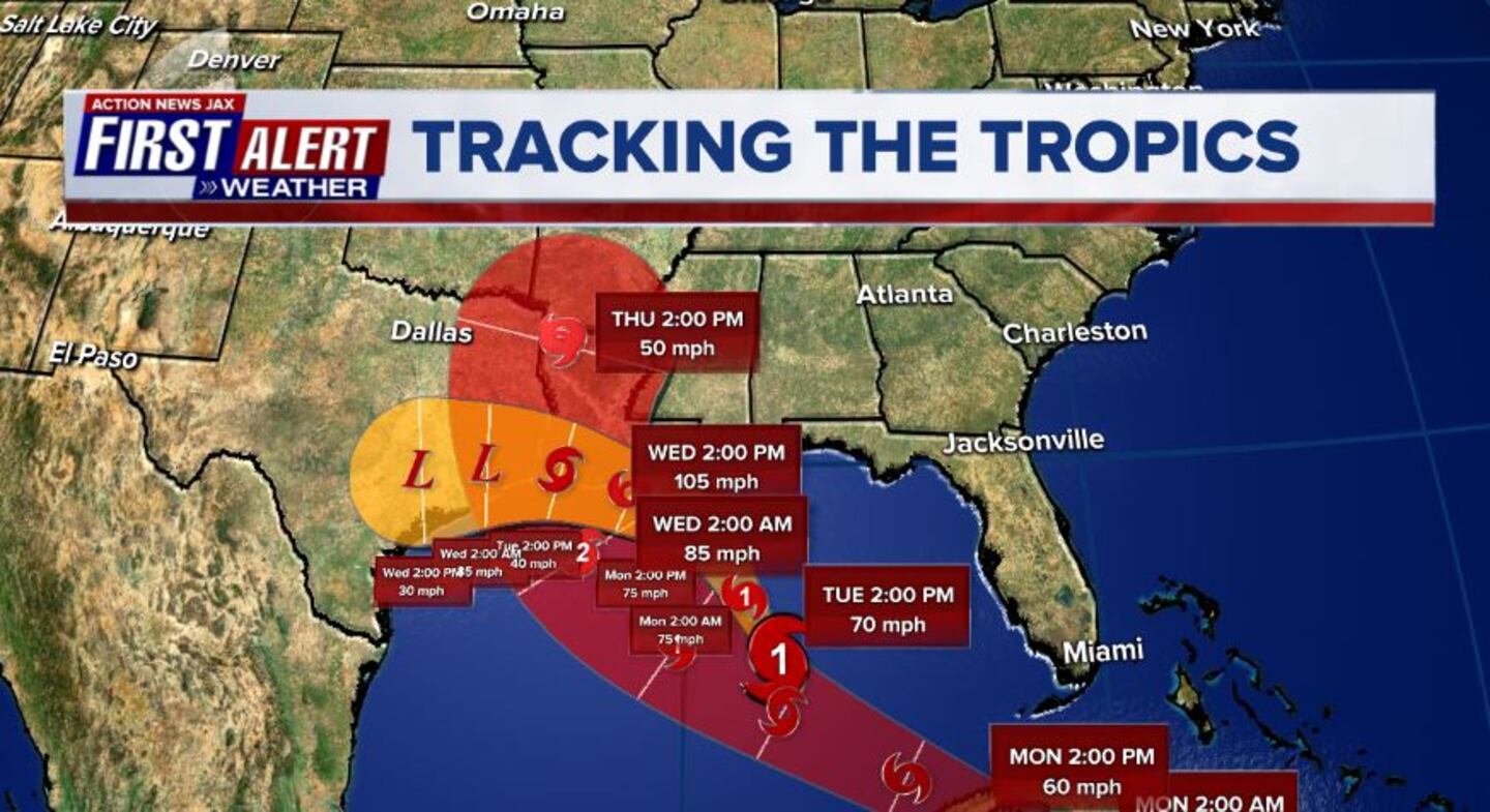
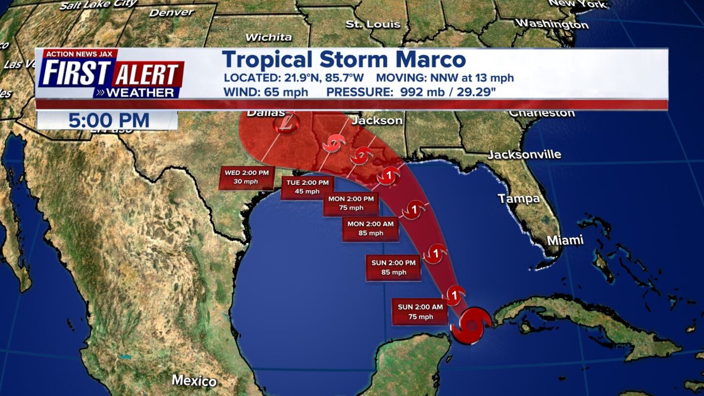
2 p.m. Update: According to the National Hurricane Center the Hurricane Hunters report that Laura has become an extremely dangerous Category 4 hurricane.
Hurricane #Laura Advisory 27A: Air Force Hurricane Hunter Aircraft Reports Laura Has Become an Extremely Dangerous Category 4 Hurricane. Catastrophic Storm Surge, Extreme Winds, and Flash Flooding Expected Along the Northwest Gulf Coast Tonight. https://t.co/VqHn0u1vgc
— National Hurricane Center (@NHC_Atlantic) August 26, 2020
11 a.m. Update: The new track for Category 3 Hurricane Laura. The National Hurricane Center says it expects Laura to be a Cat. 4 at landfall along the NW Gulf Coast.
Here is the 11 am forecast track for dangerous and destructive Hurricane #Laura.
— Garrett Bedenbaugh (@wxgarrett) August 26, 2020
Winds forecast to be 145 mph by tonight. (cat 4 is 130 mph)... NHC says they expect it to be a CAT 4 at landfall along the NW Gulf Coast. #FirstAlertWX #TXwx #LAwx pic.twitter.com/petrDfbnDM
August 24
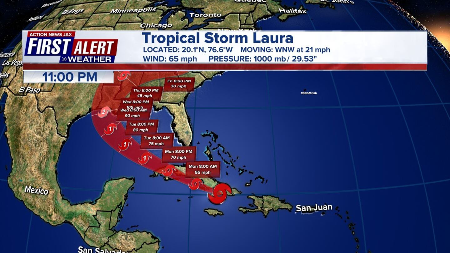
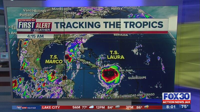
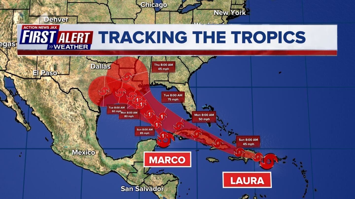
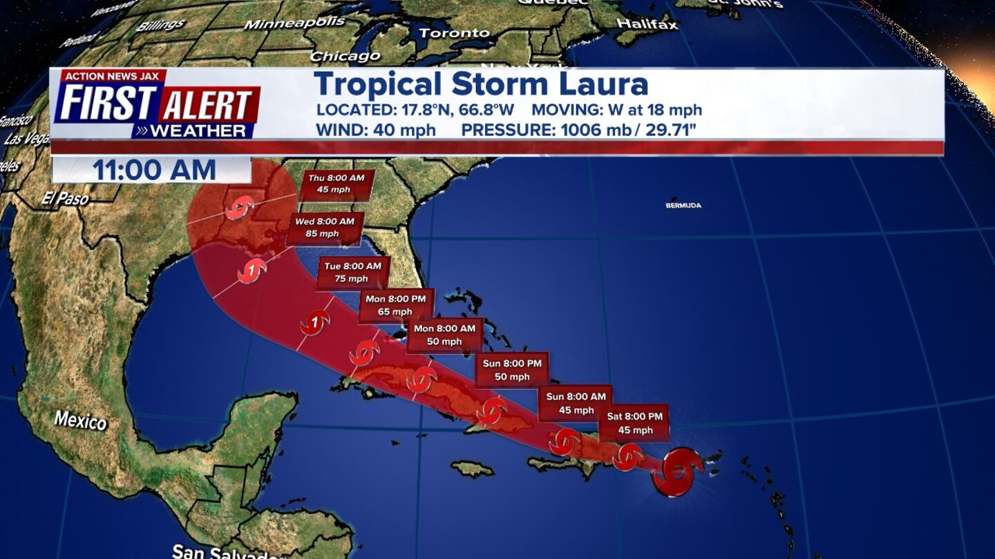
11 a.m. Update: Tropical Storm Laura is bringing heavy rainfall and flash flooding over Jamaica, the Cayman Islands and portions of Cuba. Tropical Storm Marco continues to produce heavy rainfall and gusty winds along portion of the northern Gulf Coast.
11 am advisory for Tropical Storm #Laura. #FirstAlertWX pic.twitter.com/O00UxYUtqO
— Garrett Bedenbaugh (@wxgarrett) August 24, 2020
8 a.m. Update: Tropical Storm Laura is moving west-northwestward just south of the coast of central Cuba.
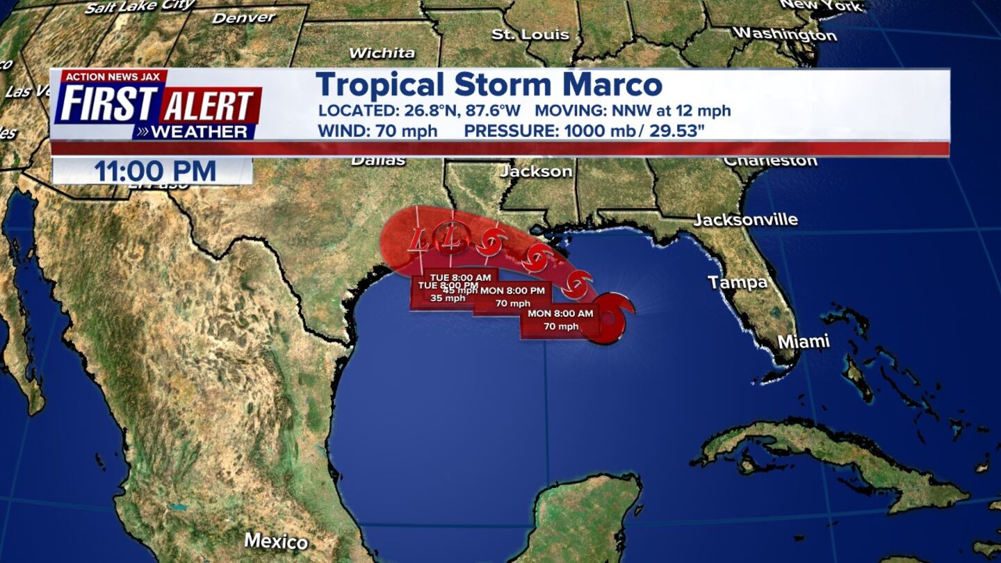
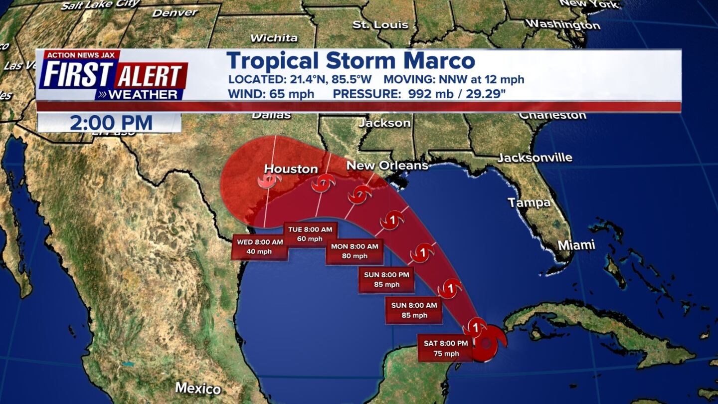
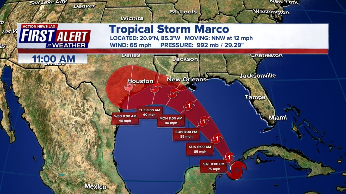
7 a.m. Update: Tropical Storm Marco is producing heavy rainfall and gusty winds along portion of the northern Gulf Coast.
5 am. Update: View the forecast advisories below for both tropical storms below.
Here is the 5 AM forecast advisories for #Marco and #Laura. #FirstAlertWX pic.twitter.com/jMiNZBeV07
— Garrett Bedenbaugh (@wxgarrett) August 24, 2020
August 23
11 p.m. Update:
5 p.m. Update:
12:30 p.m. Update:
TROPICAL UPDATE: Marco strengthens into Category 1 hurricane as it moves toward Louisiana coast pic.twitter.com/PUxUPhwrb5
— Alyssa Pejic (@AlyssaPejicWx) August 23, 2020
#Laura is forecast to intensify into a Hurricane this upcoming week-possibly a cat 2 hurricane with winds of 100 mph moving inland. pic.twitter.com/LUWNtV3ZiS
— Alyssa Pejic (@AlyssaPejicWx) August 23, 2020
8 a.m. Update:
Morning update on #Marco and #Laura. #FirstAlertWx pic.twitter.com/CY7Vg9Zvxt
— Garrett Bedenbaugh (@wxgarrett) August 23, 2020
5 a.m. Update:
Tropical Storm Marco is still forecast to become a hurricane later today. Hurricane and Storms Surge Warnings activated for portions of the Northern Gulf Of Mexico.

August 22
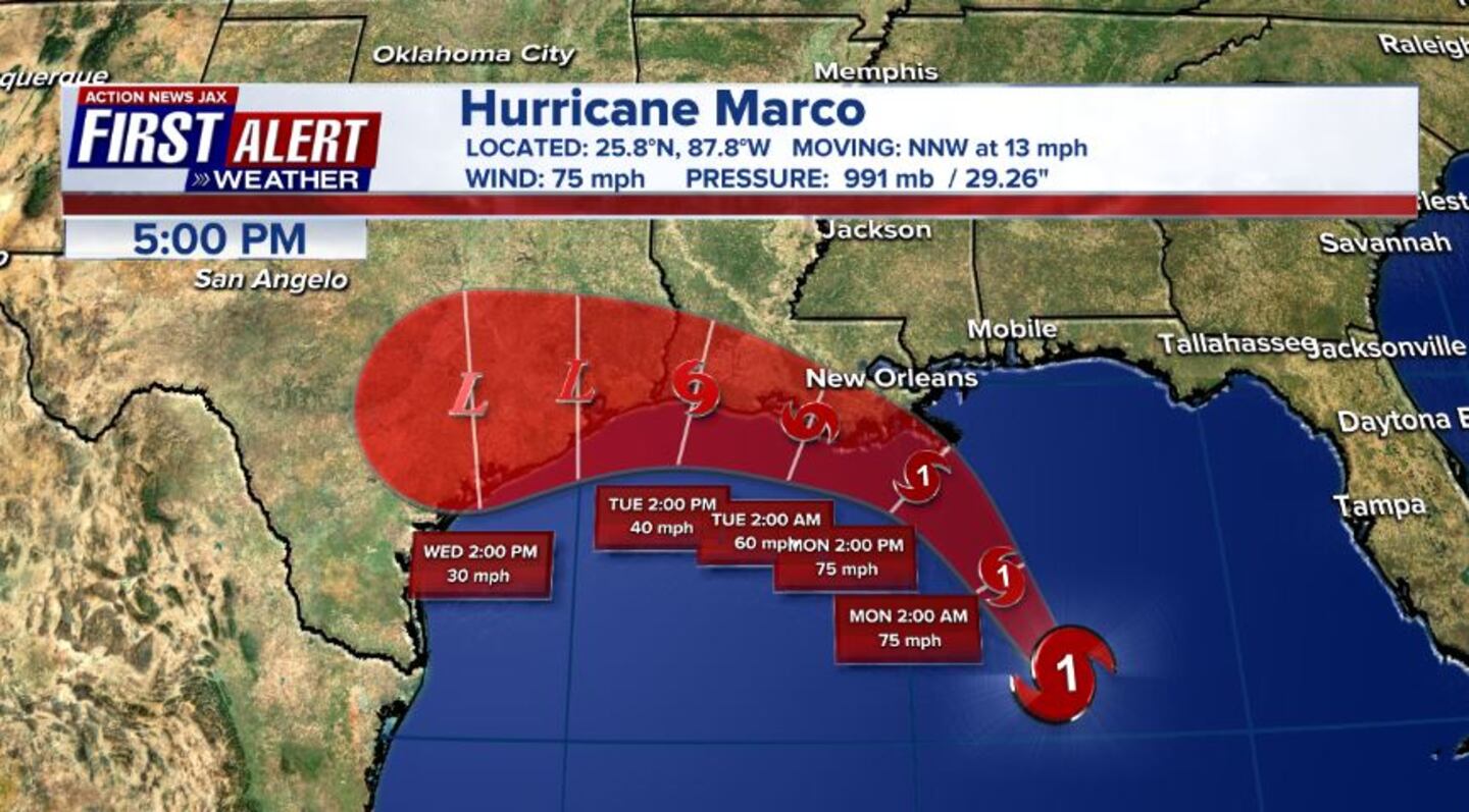
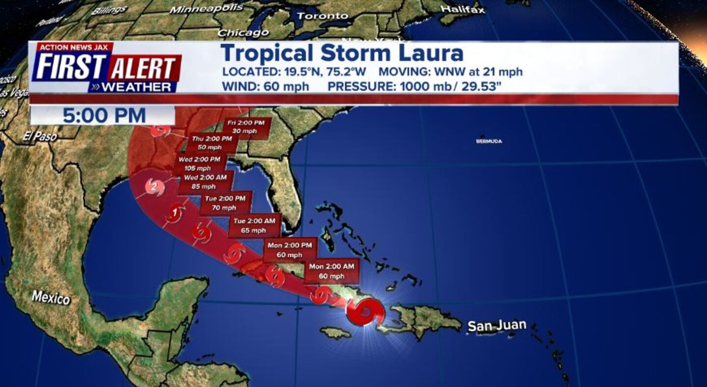
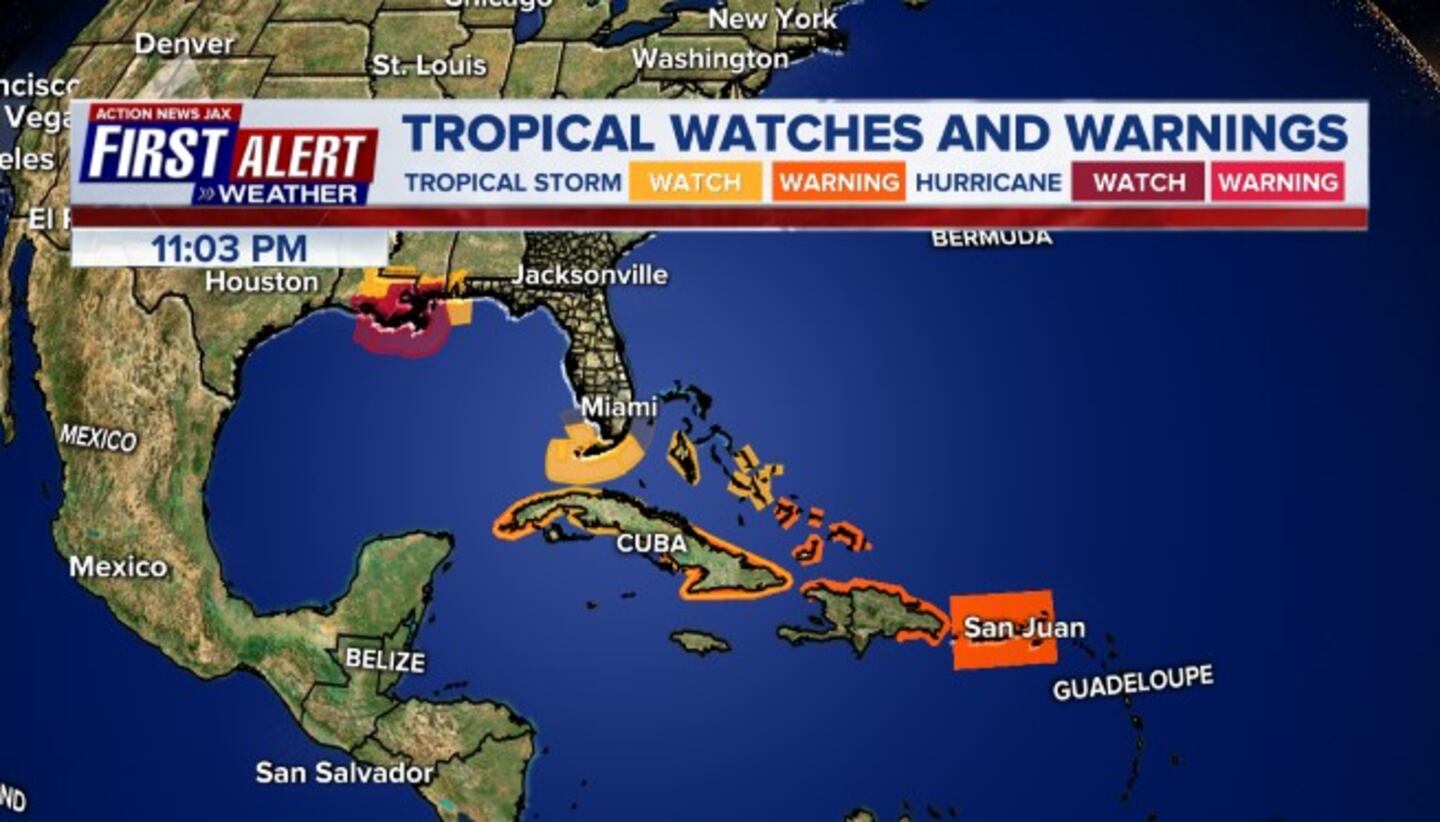
11 p.m. Update: According to the National Hurricane Center, Tropical Storm Laura continued to dump heavy rains as it moved over the Dominican Republic. A tropical storm watch is in effect for the Florida Keys from Ocean Reef to Key West and for the Dry Tortugas, including Florida Bay. Tropical Storm Marco continues to move closer to the northern Gulf coast as it entered the southern Gulf of Mexico.


5 p.m. Update: According to Meteorologist Alyssa Pejic, Tropical Storm Laura is nearing Puerto Rico, forecast to move across the Greater Antilles this weekend, and into the Gulf of Mexico Monday – strengthening into a Category 1 Hurricane. Tropical storm Marco is in the Yucatan Channel and will slowly move into the Gulf of Mexico on Sunday and Monday.
Most likely a shift East with the 5pm advisory for #Marco. I suspect some US watches will be posted as well. #FirstAlertWX
— Garrett Bedenbaugh (@wxgarrett) August 22, 2020
2 p.m. Update:
According to the National Hurricane Center, Tropical Storm Laura strengthens near Puerto Rico, while Tropical Storm Marco’s strength stays the same, still forecast to be a hurricane later today.
Tropical Storm #Laura Advisory 11A: Laura Strengthens Near Puerto Rico. https://t.co/VqHn0u1vgc
— National Hurricane Center (@NHC_Atlantic) August 22, 2020

11 a.m. Update: No major changes with the 11 a.m. advisory, but Laura now bringing heavy rain to Puerto Rico and Marco strengthening, forecasted to become a hurricane later today.
At 11 am Saturday Tropical Storm Laura was located 20 mi southwest of Ponce Puerto Rico. Laura has max sustained winds of 40 mph and is moving west at 18 mph. Laura will move near or over Hispaniola this afternoon and tonight,
— NWS Eastern Region (@NWSEastern) August 22, 2020
and near or over eastern Cuba Sunday and Sunday night pic.twitter.com/Mr5Vxyrwi1
Tropical Storm #Marco Advisory 9: Marco Strengthening Quickly. Forecast to Become a Hurricane Later Today. https://t.co/VqHn0u1vgc
— National Hurricane Center (@NHC_Atlantic) August 22, 2020
9 a.m. Update:
Cox Media Group


