
Oct. 18, 2016 — Other info. & pics are on my Twitter acc't + Facebook fan page.
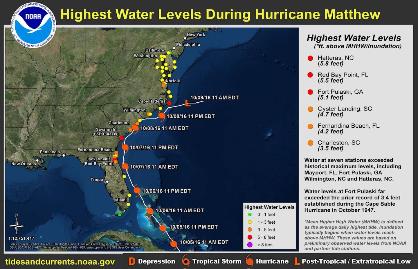
Our Jacksonville N.W.S. -- which did excellent work! -- has posted an early summary of some of the data. The highest storm surge at least approached 8 feet for parts of St. Johns & Flagler Co.... 2-5 feet for parts of Duval Co... & 4-6 feet, possibly higher in spots for Nassau Co. & Camden & Glynn Co. in Ga. Peak wind gusts were at least between 80 & 90 mph. Rainfall averaged 5-10", locally near 12" NOT including all the rain in the days leading up to "Matthew". Weekly (due to a strong onshore / 'Nor'easter' event) rainfall totals were as high as 15-20" across parts of Duval/St. Johns & Clay Co.

So.... where to begin??!!
THE WAVE:
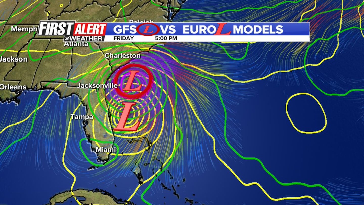
“It” all began Sept. 22nd in “Talking the Tropics With Mike” (TTTWM) as an active tropical wave moved off the coast of Africa though I talked about this pattern & wave in the days leading up to the 22nd. One of my concerns was that models -- particularly the GFS -- were too early in recurving tropical cyclones to the east this season. No way to know why, but my guess is the models were lowering pressures too much to the east of the cyclones.
So .... dates to remember....
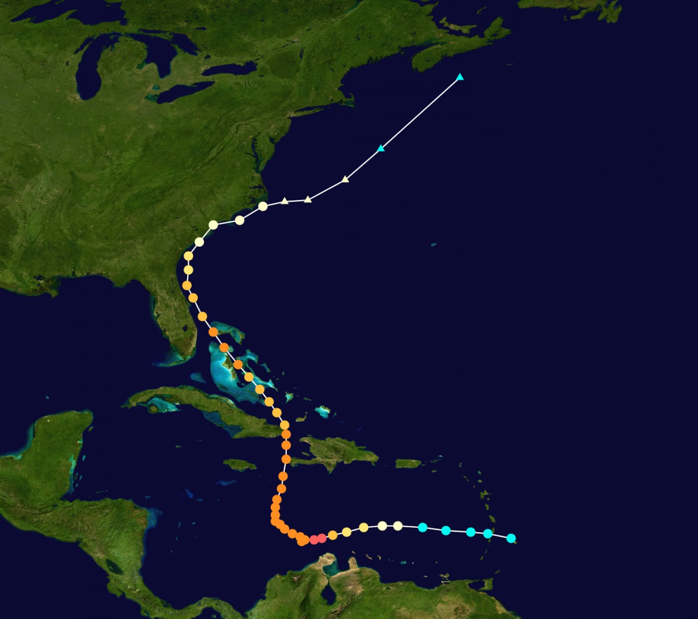
“Matthew” was a tropical wave -- a classic Cape Verde system -- that moved off the coast of Africa Sept. 22nd.
A BULLET POINT SUMMARY/RECOLLECTION AS I REMEMBER IT:
FORECAST MEMORIES THAT WILL STAND OUT FOR ME:
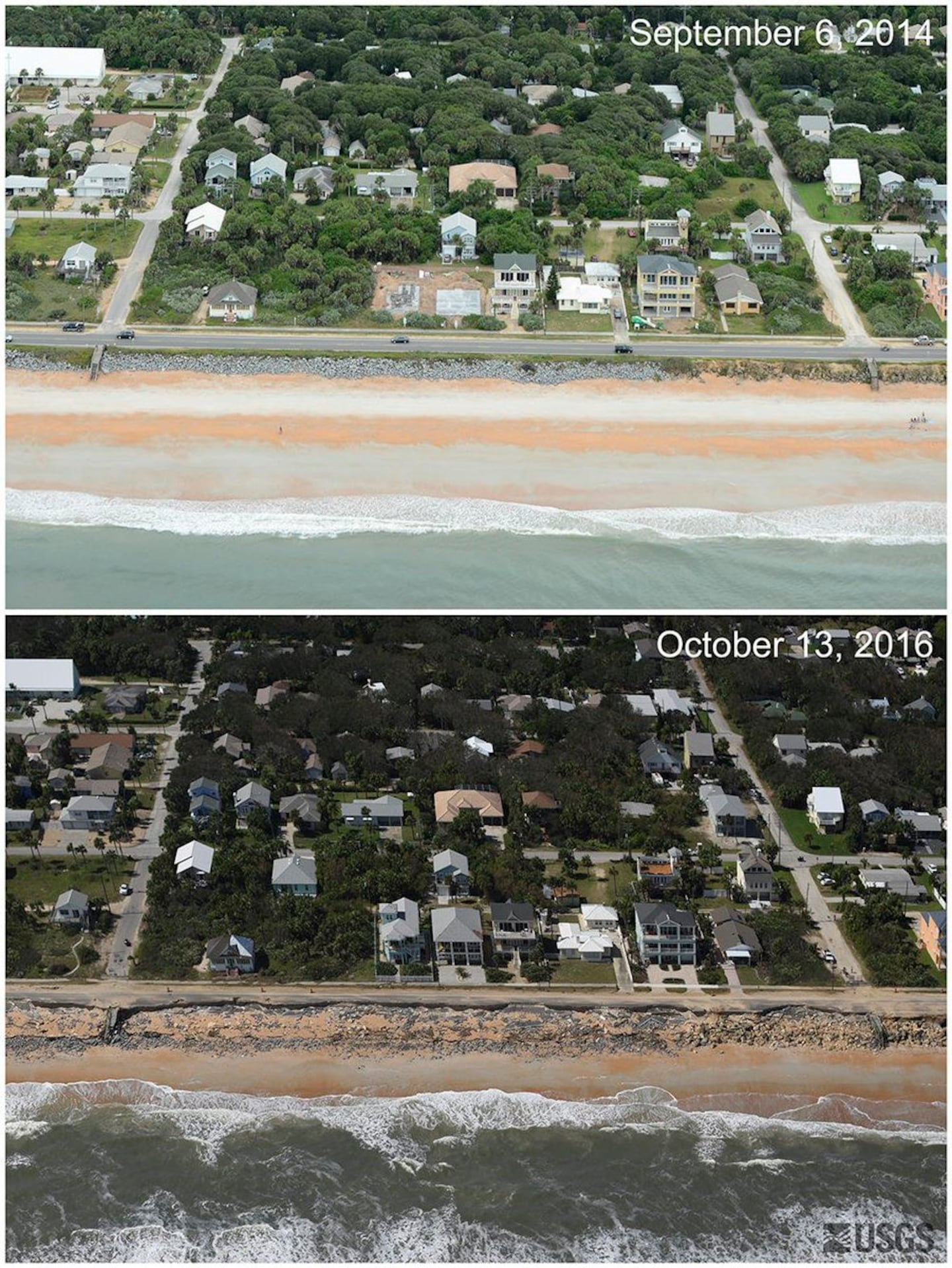
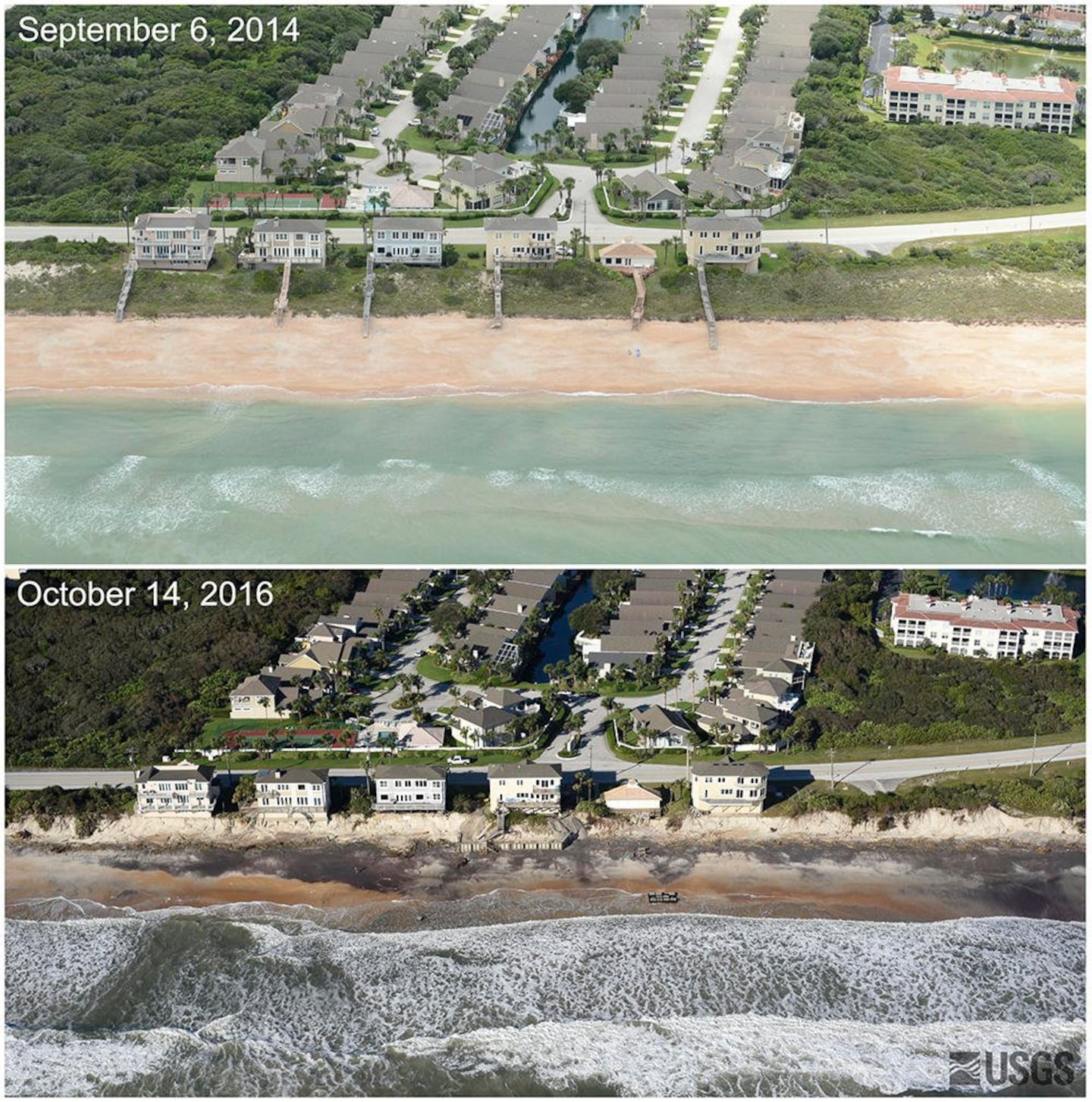
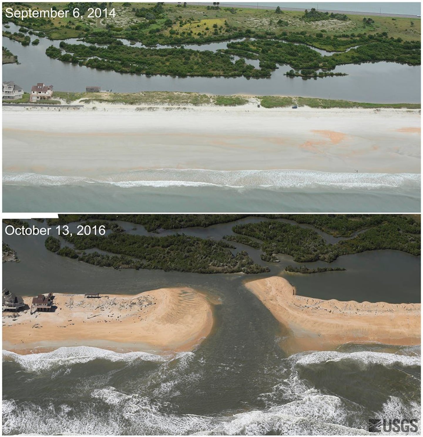
The USGS has also released before & after photos from "Matthew".....
Flagler Beach:
Vilano Beach:
New inlet near Matanzas River, St. Johns Co.:
From our Jax N.W.S. (preliminary):
POST TROPICAL CYCLONE REPORT...HURRICANE MATTHEW...UPDATED
NATIONAL WEATHER SERVICE JACKSONVILLE FL 348 PM EDT MON OCT 31 2016 NOTE: THE DATA SHOWN HERE ARE PRELIMINARY....AND SUBJECT TO UPDATES AND CORRECTIONS AS APPROPRIATE. THIS REPORT INCLUDES EVENTS OCCURRING WHEN WATCHES AND/OR WARNINGS WERE IN EFFECT...OR WHEN SIGNIFICANT FLOODING ASSOCIATED WITH MATTHEW COUNTIES INCLUDED...PUTNAM...NASSAU...ST JOHNS...MARION...DUVAL... FLAGLER...ALACHUA...BACON...GLYNN OCT 13...UPDATED... OCT 20...UPDATED FOR...METAR OBSERVATIONS, STORM SURGE, AND CORRECTION IN MARINE OBSERVATIONS. OCT 24...UPDATED FOR...NWS STORM TIDE SURVEY INFORMATION HAS BEEN ADDED. PLEASE NOTE THE PROVISIONS ON THAT DATA IN THE STORM TIDE-SURGE REMARKS. OCT 27...ADDED STORM TIDE HEIGHTS ABOVE MHHW...AGL ALONG THE IMMEDIATE COAST...FOR WATER MARKS SURVEYED TODAY. WATER MARKS WERE AT THE DOCKS FOR THE FORT MATANZAS NATIONAL MONUMENT...NM...AND ON RATTLESNAKE ISLAND AND THE FORT ITSELF. ALL WERE VERY CONSISTENT ACROSS THE FORT MATANZAS NM FROM THE OCEANFRONT TO THE EAST ICWW DOCK AND ON RATTLESNAKE ISLAND AND THE FORT DOCKS ON THE WEST SIDE OF THE ICWW. THANKS GO OUT TO THE NATIONAL PARK SERVICE FOR FACILITATING THE SURVEY. BASED ON NEW INFORMATION THE WATER LEVEL AT TREASURE BEACH AND THE MATANZAS INLET RESTURANT AREA HAVE BEEN INCREASED TO 7 FEET MHHW. IT IS POSSIBLE A LATER SURVEY COULD FIND HIGHER WATER VALUES BUT WE BELIEVE THESE TO BE WITHIN A FOOT OF ACCURACY AT THIS TIME. OCT 31...UPDATED AND INCREASED PALM COAST ICWW STORM TIDE FOR SECTION C FROM 5.0 TO 5.5 FEET ABOVE MHHW. THIS IS BASED ON NEW INFORMATION PROVIDED BY FLAGLER COUNTY E.M.A. AND A RESIDENT. A. LOWEST SEA LEVEL PRESSURE/MAXIMUM SUSTAINED WINDS AND PEAK GUSTS --------------------------------------------------------------------- METAR OBSERVATIONS... NOTE: ANEMOMETER HEIGHT IS 10 METERS AND WIND AVERAGING IS 2 MINUTES --------------------------------------------------------------------- LOCATION ID MIN DATE/ MAX DATE/ PEAK DATE/ LAT LON PRES TIME SUST TIME GUST TIME DEG DECIMAL (MB) (UTC) (KT) (UTC) (KT) (UTC) --------------------------------------------------------------------- KJAX-JACKSONVILLE INTERNATIONAL AIRPORT FL 30.49 -81.69 989.8 07/2156 360/039 07/1920 010/056 07/1919 KCRG-CRAIG MUNICIPAL AIRPORT FL 30.33 -81.52 986.1 07/2053 360/041 07/2006 020/060 07/1937 KNIP-JACKSONVILLE NAVAL AIR STATION FL 30.24 -81.68 988.5 07/2053 330/042 07/1909 330/059 07/1958 KVQQ-CECIL FIELD AIRPORT FL 30.22 -81.88 9999.0 / I 310/032 07/2215 310/048 08/0215 KSGJ-SAINT AUGUSTINE AIRPORT FL 29.97 -81.33 982.1 07/1858 010/044 07/1721 360/059 07/1818 KVVG-THE VILLAGES FL 28.96 -81.97 9999.0 / I 200/026 07/1815 200/035 07/1815 KOCF-OCALA INTERNATIONAL AIRPORT FL 29.18 -82.22 997.6 07/1850 330/020 07/1650 330/034 07/1550 K42J-KEYSTONE HEIGHTS FL 29.85 -82.05 999.3 07/1535 360/024 07/1535 300/036 08/0315 KGNV-GAINESVILLE REGIONAL AIRPORT FL 29.68 -82.27 996.5 07/1953 330/029 07/1917 330/042 07/1917 KLCQ-LAKE CITY FL 30.18 -82.58 999.3 07/2135 340/024 07/2015 340/036 07/2035 KAYS-WAYCROSS GA 31.25 -82.40 998.1 08/0555 360/027 08/0455 350/039 08/0355 KAMG-BACON COUNTY AIRPORT GA 31.54 -82.50 998.8 08/0653 350/024 08/0210 340/036 08/0407 KJES-JESUP GA 31.55 -81.88 993.0 08/0450 350/029 08/0335 020/050 08/0015 KBQK-BRUNSWICK/GLYNCO AIPORT GA 31.15 -81.47 986.0 08/0535 030/028 07/2015 310/047 08/0335 KFHB-FERNANDINA BEACH FL 30.61 -81.46 984.6 07/2235 310/038 08/0155 300/052 08/0235 REMARKS: INCOMPLETE DATA. OBSERVATION DROPPED OUT AT 08/0450Z. DID NOT INCLUDE KNRB-MAYPORT DUE TO INCOMPLETE OBSERVATIONS. NON-METAR OBSERVATIONS... NOTE: ANEMOMETER HEIGHT IN METERS AND WIND AVERAGING PERIOD IN MINUTES INDICATED UNDER MAXIMUM SUSTAINED WIND IF KNOWN --------------------------------------------------------------------- LOCATION ID MIN DATE/ MAX DATE/ PEAK DATE/ LAT LON PRES TIME SUST TIME GUST TIME DEG DECIMAL (MB) (UTC) (KT) (UTC) (KT) (UTC) --------------------------------------------------------------------- XJAX - WEATHERFLOW JACKSONVILLE BEACH PIER 30.29 -81.39 983.6 07/2105 073/053 07/1735 073/066 07/1735 12/02 XHUP - HUGUENOT PARK 30.41 -81.41 981.9 07/2143 015/051 07/1923 035/069 07/1853 12/02 XJAK - BUCK ISLAND 30.39 -81.48 979.4 07/2048 010/051 07/1943 000/071 07/2008 10/02 XHSE - WEATHERFLOW CRESCENT BEACH SUMMERHOUSE 29.71 -81.23 977.6 07/1815 355/049 07/1725 009/065 07/1645 05/02 XLWS - WEATHERFLOW LEWIS ST. JOHNS 29.91 -81.33 976.9 07/1929 360/039 07/1659 001/058 07/1709 15/02 E8915 - 2 WNW SILVER SPRING SHORES 29.12 -82.05 999/999 287/049 07/1737 JONG1 - 1 WNW STEVEN FOSTER STATE PARK 30.83 -82.36 999/999 006/043 08/0301 E0808 - PALM COAST 29.57 -81.21 999/999 355/043 07/1456 D1274 - JACKSONVILLE HEIGHTS 30.29 -81.87 999/999 241/042 08/0422 E1959 - 3 SE WELAKA 29.44 -81.63 999/999 278/042 07/1905 AS289 - 1 SW SAN PABLO 30.27 -81.46 999/999 035/041 07/1601 BKBF1 - 1 NNE ORANGE PARK 30.19 -81.69 999/999 320/041 07/2236 BYXG1 - 4 SW BAXLEY 31.71 -82.39 999/999 183/038 08/0104 D9112 - 4 NW INTERLACHEN 29.67 -81.95 999/999 306/038 07/1529 OKEG1 - 2 W DEENWOOD 30.25 -82.40 999/999 345/038 08/0404 BHC - BAXLEY MUNICIPAL AIRPORT 31.71 -82.39 999/999 360/037 08/0315 TT331 - 11 NNW STEVEN FOSTER STATE PARK 30.98 -82.40 999/999 340/037 08/0310 C0041 - 3 S BOYS ESTATE 31.27 -81.48 999/999 035/035 07/2222 D8234 - 1 NW FRUIT COVE 30.11 -81.64 999/999 115/034 07/1855 C0639 - 1 SE ORTEGA 30.26 -81.70 999/999 039/034 07/1948 C1450 - 5 WNW NEWBERRY 29.67 -82.70 999/999 301/034 07/1930 XJEK 31.05 -81.41 983.7 07/0311 030/036 07/2216 020/056 07/2201 10/02 BLIF1 - BLOUNT ISLAND COMMAND 30.39 -81.52 986.4 07/2124 345/036 07/2000 350/056 07/2012 20/02 REMARKS: B. MARINE OBSERVATIONS... NOTE: ANEMOMETER HEIGHT IN METERS AND WIND AVERAGING PERIOD IN MINUTES INDICATED UNDER MAXIMUM SUSTAINED WIND IF KNOWN --------------------------------------------------------------------- LOCATION ID MIN DATE/ MAX DATE/ PEAK DATE/ LAT LON PRES TIME SUST TIME GUST TIME DEG DECIMAL (MB) (UTC) (KT) (UTC) (KT) (UTC) --------------------------------------------------------------------- SAUF1-CMAN STATION SAINT AUGUSTINE FL 29.86 -81.26 978.9 07/1900 004/057 07/1730 360/075 07/1728 16.5 FRDF1-NOS STATION FERNANDINA BEACH FL 30.67 -81.47 987.4 07/2236 345/034 08/0318 345/051 07/2200 3.8 METERS MYPF1-NOS STATION MAYPORT FL 30.40 -81.43 985.3 07/2112 016/046 07/2006 026/065 07/1854 7 GTXF1-NERR STATION GUANA TOLOMAO MATANZAS FL 29.66 -81.22 979.0 07/1845 350/041 07/1630 999/999 2.3 METERS RED BAY PT, ST JOHNS RIVER 29.97 -81.63 986.9 07/2012 322/044 07/1824 327/060 07/1918 REMARKS: C. STORM TOTAL RAINFALL FROM 1200 UTC OCT 06 UNTIL 1200 UTC OCT 08 --------------------------------------------------------------------- CITY/TOWN COUNTY ID RAINFALL LAT LON (IN) DEG DECIMAL --------------------------------------------------------------------- 2 WSW PICOLATA CLAY FL-CY-19 10.30 29.90 -81.63 2 SSW COUNTRY CLUB ESTAT GLYNN GA-BR 10.29 31.18 -81.48 3 NNW BAKERSVILLE ST. JOHNS FL-SJ-16 9.97 29.94 -81.51 4 WNW BAYARD DUVAL FL-DV-51 9.63 30.17 -81.57 5 ESE THALMANN GLYNN STRG1 9.57 31.26 -81.61 1 SSE ARLINGTON DUVAL FL-DV-28 9.55 30.31 -81.60 11.90 N JACKSONVILLE DUVAL FL-DV-37 9.39 32.89 -81.62 3 NNE OCEANWAY DUVAL FL-DV-37 9.39 30.50 -81.62 4 WSW SWITZERLAND CLAY FL-CY-37 9.29 30.06 -81.71 1 S JACKSONVILLE HEIGHTS DUVAL FL-DV-42 8.15 30.23 -81.79 1 S JACKSONVILLE HEIGHTS DUVAL FL-DV-42 8.15 30.24 -81.79 1 W BELLAIR-MEADOWBROOK CLAY FL-CY-8 8.05 30.18 -81.75 2 W SWITZERLAND CLAY FL-CY-1 7.91 30.08 -81.70 3 W SWITZERLAND CLAY FL-CY-1 7.91 30.07 -81.69 2 NW SAN PABLO DUVAL FL-DV-32 7.89 30.31 -81.47 2 WNW SAN PABLO DUVAL FL-DV-32 7.89 30.31 -81.46 2 S DOCTORS INLET CLAY FL-CY-4 7.79 30.08 -81.76 2 NNW ORTEGA DUVAL FL-DV-34 7.55 30.29 -81.72 1 N LAKESIDE CLAY FL-CY-25 7.54 30.14 -81.77 1 N LAKESIDE CLAY FL-CY-25 7.54 30.14 -81.77 2.10 SSW ST. AUGUSTINE S ST. JOHNS FL-SJ-4 7.48 29.78 -81.32 2 ENE JACKSONVILLE HEIGH DUVAL FL-DV-63 7.44 30.25 -81.75 3 WNW ORANGE MILLS PUTNAM FL-PT-8 7.22 29.69 -81.63 CRAIG MUNICIPAL AIRPORT DUVAL CRG 7.19 30.34 -81.51 1 NNE ORANGE PARK CLAY FL-CY-10 7.07 30.17 -81.70 1 WNW ORTEGA DUVAL FL-DV-3 6.97 30.27 -81.73 1 SSE ORTEGA DUVAL C0639 6.87 30.26 -81.70 1 SSE ORTEGA DUVAL C0639 6.87 30.26 -81.70 NORMANDY DUVAL FL-DV-69 6.87 30.30 -81.76 4 W NORMANDY DUVAL FL-DV-33 6.83 30.30 -81.82 3 N ARLINGTON DUVAL FL-DV-59 6.82 30.37 -81.60 JACKSONVILLE INTL AIRPOR DUVAL JAX 6.75 30.48 -81.70 4 SW UNF DUVAL FL-DV-79 6.70 30.22 -81.56 4 SW UNIVERSITY OF NORTH DUVAL FL-DV-79 6.70 30.23 -81.56 3 NE FLORAHOME PUTNAM FL-PT-1 6.60 29.75 -81.84 PALM COAST FLAGLER E0808 6.52 29.57 -81.21 SATILLA RIVER AT US 17 A CAMDEN SRWG1 6.34 30.97 -81.73 2 WSW ORTEGA DUVAL FL-DV-26 6.31 30.26 -81.74 4 ESE HICKOX BRANTLEY GA-BY-1 6.29 31.12 -81.93 4 ESE HICKOX BRANTLEY GA-BY-1 6.29 31.12 -81.93 7 N JESUP WAYNE GA-WY-2 6.14 31.70 -81.89 5 NW DOCTORTOWN WAYNE GA-WY-2 6.14 31.70 -81.90 1 SE SAN MARCO DUVAL E7043 6.12 30.30 -81.64 JACKSONVILLE NAS DUVAL NIP 6.03 30.23 -81.68 3 WNW HASTINGS PUTNAM HASF1 6.01 29.76 -81.54 2 NE BUNNELL FLAGLER FL-FL-25 6.00 29.48 -81.22 4 N JESUP WAYNE GA-WY-6 5.76 31.66 -81.90 3 ENE MANDARIN DUVAL FL-DV-47 5.66 30.17 -81.58 4 ENE MANDARIN DUVAL FL-DV-47 5.66 30.17 -81.58 1 SE ORTEGA DUVAL D7456 5.45 30.25 -81.69 6 NE LAKE GENEVA CLAY FL-CY-5 5.43 29.84 -81.92 7 NNE PUTNAM HALL CLAY FL-CY-5 5.43 29.83 -81.92 3 W BELLAIR CLAY D8274 5.34 30.18 -81.81 1 SW ORTEGA DUVAL E9221 5.30 30.26 -81.72 2 SE DOCTORS INLET CLAY FL-CY-2 5.28 30.10 -81.74 2 ENE SCREVEN WAYNE GA-WY-7 5.27 31.49 -81.98 4 NNW JESUP WAYNE GA-WY-8 5.25 31.65 -81.90 6 NE ODUM WAYNE GA-WY-4 5.20 31.73 -81.96 4 NNE MANDARIN DUVAL C4952 5.17 30.21 -81.60 1 SW SAN PABLO DUVAL AS289 5.12 30.27 -81.46 6 NNE PUTNAM HALL CLAY FL-CY-3 5.12 29.81 -81.93 6 NE NAHUNTA BRANTLEY NAHG1 5.10 31.27 -81.92 9 NNE PUTNAM HALL CLAY FL-CY-14 4.98 29.86 -81.92 2 SW SAN MATEO PUTNAM FL-PT-7 4.72 29.59 -81.61 5 NW SALT SPRINGS MARION LGRF1 4.65 29.40 -81.81 3 NE LAKE GENEVA CLAY FL-CY-7 4.61 29.79 -81.98 4 NW MIDDLEBURG CLAY FL-CY-40 4.34 30.08 -81.95 8 N FLORAHOME CLAY FL-CY-38 4.34 29.85 -81.90 9 N FLORAHOME CLAY FL-CY-38 4.31 29.86 -81.90 2 W PALM COAST FLAGLER AT417 4.28 29.57 -81.25 1 NW FRUIT COVE ST. JOHNS D8234 4.25 30.11 -81.64 3 SE WELAKA PUTNAM E1959 3.89 29.44 -81.63 2 N CRESCENT CITY PUTNAM FL-PT-21 3.85 29.46 -81.52 4 SW BAXLEY APPLING BXYG1 3.66 31.71 -82.39 1 SW INTERLACHEN PUTNAM FL-PT-10 3.60 29.60 -81.91 2 W DEENWOOD WARE OKEG1 3.35 31.25 -82.40 1 ESE PALM COAST FLAGLER FL-FL-21 3.18 29.56 -81.20 11 NNW STEVEN FOSTER STA CHARLTON TT331 3.13 30.98 -82.40 10 SW FOLKSTON CHARLTON TS818 3.09 30.74 -82.13 1 ESE STARKE BRADFORD FL-BF-2 2.97 29.94 -82.10 BACON COUNTY AIRPORT BACON AMG 2.88 31.54 -82.51 2 S MACCLENNY BAKER FL-BK-2 2.85 30.24 -82.12 1 WNW STEVEN FOSTER STAT CHARLTON JONG1 2.75 30.83 -82.36 1 WSW HOG VALLEY MARION FL-MR-46 2.68 29.48 -81.90 4 NNE FLORAHOME PUTNAM FL-PT-12 2.58 29.78 -81.85 4 S GLEN ST. MARY BAKER FL-BK-7 2.23 30.21 -82.16 3 WNW MANOR WARE GA-WR-5 2.21 31.12 -82.62 3 ESE SANDERSON BAKER FL-BK-5 2.14 30.24 -82.22 3 ESE SANDERSON BAKER FL-BK-5 2.14 30.23 -82.22 4 NW INTERLACHEN PUTNAM D9112 2.04 29.67 -81.95 3 SSW LAKE WEIR MARION FL-MR-20 2.00 28.97 -82.00 REMARKS: D. INLAND FLOODING... --------------------------------------------------------------------- ST JOHNS... SPUF1 - DEEP CREEK AT SPUDS REPORTED MAJOR FLOODING STORM TIDE OF 5.72 FEET NAVD88 AT 08/0400Z. DUVAL... JULF1 - JULINGTON CREEK AT OLD ST AUGUSTINE ROAD REPORTED MAJOR FLOODING STORM TIDE OF 4.61 FEET NAVD88 AT 08/0800Z. TRJF1 - TROUT RIVER AT LEM TURNER ROAD REPORTED MODERATE FLOODING STORM TIDE OF 3.52 FEET NAVD88 AT 07/2015Z. DCDF1 - DUNN CREEK AT DUNN CREEK ROAD REPORTED MODERATE FLOODING STORM TIDE OF 4.09 FEET NAVD88 AT 07/2145Z. CCJF1 - CLAPBOARD CREEK NEAR SHEFFIELD ROAD REPORTED MODERATE FLOODING STORM TIDE OF 4.36 FEET NAVD88 AT 07/1930Z. PCUF1 - POTTSBURG CREEK AT BEACH BLVD REPORTED MODERATE FLOODING STORM TIDE OF 4.44 FEET AT 07/2300Z. PSJF1 - POTTSBURG CREEK AT BOWDEN ROAD REPORTED MODERATE FLOODING STORM TIDE OF 8.63 FEET NAVD88 AT 07/2315Z. ORKF1 - ORTEGA RIVER AT ARGYLE FOREST BLVD REPORTED MINOR FLOODING STORM TIDE OF 10.63 FEET NAVD88 AT 08/0215Z. CLAY... BCMF1 - BLACK CREEK AT MIDDLEBURG REPORTED MINOR FLOODING STORM TIDE OF 4.03 FEET NAVD88 AT 08/0300Z. PNYF1 - SOUTH FORK AT BLACK CREEK REPORTED MINOR FLOODING STORM TIDE OF 25.24 FEET NAVD88 AT 08/1230Z. FLAGLER... RLGF1 - HAW CREEK ABOVE RUSSELL LANDING REPORTED MODERATE FLOODING STORM TIDE OF 5.19 FEET NAVD88 AT 08/1700Z. --------------------------------------------------------------------- E. MAXIMUM STORM SURGE AND STORM TIDE... OFFICIAL TIDE GAUGES NOTED WITH LEADING G --------------------------------------------------------------------- COUNTY CITY/TOWN SURGE TIDE DATE/ BEACH OR LOCATION (FT) (FT) TIME EROSION --------------------------------------------------------------------- PUTNAM PALF1 - ST JOHN 3.23 3.80 08/0300 UNKNOWN PUTNAM DUNNS CREEK NEA 3.85 4.33 08/0130 UNKNOWN ST JOHNS RACY POINT 5.20 4.55 07/2236 UNKNOWN CLAY ST JOHNS RIVER 3.77 3.08 08/0030 UNKNOWN DUVAL CEDAR RIVER AT 2.68 3.30 08/0715 UNKNOWN DUVAL MAIN STREET BRI 2.13 2.31 08/0730 UNKNOWN DUVAL ACOSTA BRIDGE 2.31 2.94 08/0715 UNKNOWN DUVAL TROUT RIVER AT 2.27 3.52 07/2015 UNKNOWN DUVAL BROWARD RIVER B 3.17 4.47 07/2300 UNKNOWN DUVAL DAMES POINT BRI 3.67 2.80 07/2000 UNKNOWN DUVAL MAYPORT 4.69 3.28 07/1854 UNKNOWN NASSAU FERNANDINA BEAC 6.95 4.17 07/1930 MAJOR NASSAU ST MARYS RIVER 2.79 5.26 07/2230 UNKNOWN CAMDEN SEA CAMP DOCK A 3.65 7.00 07/1930 UNKNOWN CAMDEN SATILLA RIVER A 1.73 5.11 07/2130 UNKNOWN GLYNN ATLANTIC COAST 3.18 6.15 07/1900 UNKNOWN ST JOHNS TOLOMATO RIVER 3.61 5.55 07/1954 UNKNOWN FLAGLER BING`S LANDING 5.19 5.85 07/2200 UNKNOWN FLAGLER SURFISIDE ESTAT 0.00 2.00 07/1200 NONE FLAGLER BEVERLY BEACH O 0.00 7.00 07/1200 MAJOR FLAGLER SEA COLONY 0.00 4.50 07/1200 UNKNOWN FLAGLER .5 S MARINELAND 0.00 7.00 07/1200 MAJOR FLAGLER BINGS LANDING 0.00 5.50 07/1200 NONE ST JOHNS OLD A1A SUMMERH 0.00 6.00 07/1400 MAJOR ST JOHNS TREASURE BCH 0.00 7.00 07/1400 MAJOR ST JOHNS MATANZAS OCNFRN 0.00 7.00 07/1400 MAJOR ST JOHNS FT MATANZAS OCE 0.00 7.00 07/1400 MAJOR ST JOHNS ST AUG BCH 0.00 6.00 07/1400 MAJOR FLAGLER PALM COAST "C" 0.00 5.50 07/1200 NONE ST JOHNS BUTLER BCH ICWW 0.00 6.00 07/1400 NONE ST JOHNS DAVIS SHORES BA 0.00 5.00 07/1400 NONE ST JOHNS CONCH HOUSE 0.00 3.00 07/1400 NONE ST JOHNS ST AUGUSTINE BA 0.00 5.00 07/1500 NONE ST JOHNS CASTILLO S.M. 0.00 4.00 07/1500 NONE ST JOHNS LINCOLNVILLE 0.00 5.00 07/1400 NONE ST JOHNS VILANO BCH 0.00 6.00 07/1500 MAJOR ST JOHNS GUANA RESEARCH 0.00 4.50 07/1600 MAJOR DUVAL OAK LANDING/JTB 0.00 3.00 07/1800 NONE DUVAL LIFESAVING STN 0.00 5.00 07/1700 MAJOR DUVAL BROWNS CREEK 0.00 2.00 07/1800 NONE NASSAU FERN HBR MARINA 0.00 3.00 07/1930 NONE NASSAU TIGER PT MARINA 0.00 3.00 07/2000 NONE NASSAU A1A EGANS CRK 0.00 2.50 07/2000 NONE NASAU EGANS CRK SADLE 0.00 1.00 07/2000 NONE GLYNN LIBERTY HARBOR 0.00 2.00 08/0000 NONE GLYNN BRUNSWICK DNR 0.00 1.50 08/0000 NONE GLYNN MARSHSIDE REST 0.00 2.00 08/0000 NONE GLYNN BELLE PT PLANTA 0.00 3.00 08/0000 NONE PUTNAM DEEP CRK-FDRL P 0.00 3.50 UNKNOWN NONE PUTNAM FEDERAL PT WEST 0.00 3.50 UNKNOWN NONE PUTNAM RIVERSHORE DR 0.00 2.50 UNKNOWN NONE PUTNAM DUNNS CREEK 0.00 3.00 UNKONWN NONE PUTNAM SPORTSMANS HRBR 0.00 2.50 UNKNOWN NONE ST JOHNS FT MATANZAS NM 0.00 7.00 07/1400 MAJOR REMARKS: STORM TIDE DATUM IS WITH RESPECT TO MEAN HIGHER HIGH WATER...MHHW... AND STORM TIDE TIME IN UTC THIS APPROXIMATES ABOVE GROUND LEVEL...AGL...ALONG THE IMMEDIATE SHORELINE AREAS. STORM TIDE VALUES ON THE ST JOHNS RIVER AT RACY POINT HAD A RECORD SURGE OF 5.2 FEET. ST JOHNS RIVER AT BUCKMAN BRIDGE THE 2ND HIGHEST SURGE. ST JOHNS RIVER AT DAMES POINT BRIDGE RECORD SURGE. ST JOHNS RIVER AT MAYPORT 2ND HIGHEST SURGE. TIDE GAUGE AT FERNANDINA BEACH 3RD HIGHEST SURGE. TIDE GAUGE AT RED BAY ON THE ST JOHNS RIVER WAS SWEPT WAY BY SURGE AND WAVE ACTION. NWS SURVEY...THE POINTS WITH NO SURGE VALUES ARE PRELIMINARY...REPEAT PRELIMINARY...WATER DEPTHS WITH RESPECT TO MHHW BASED ON THE LOCAL NWS WFO JACKSONVILLE STORM TIDE SURVEY. THEY ARE SUBJECT TO REVISION WHEN MORE ACCURATE USGS AND NHC STORM SURGE UNIT SURVEYS BECOME AVAILABLE. WHILE WE DID OUR BEST TO FIND ACCURATE STILL WATER HEIGHTS AND ESTIMATE THEIR DEPTH RELATIVE TO MHHW DUE THE THE LARGE AREA IMPACTED WE COULD NOT VISIT ALL NECESSARY SITES. WHENEVER POSSIBLE AND INTERIOR WATER MARK FROM A GARAGE OR SHELTERED PORCH NEAR GROUND LEVEL WAS CHOSEN. AS WE DID NOT HAVE ACCESS TO MANY OF THE STRUCTURES MANY WATER LINES-MARKS WERE OUTDOOR SITES IN LOCATIONS RELATIVELY SHELTERED FROM WAVE ACTION BUT STILL POSSIBLY SUBJECT TO WAVE RUN UP AND WAVE CONTAMINATION. SOME SITES SUCH AS THE HOMES SOUTH OF MARINELAND AND THE MATANZAS INLET RESTAURANT WERE SUBJECT TO FULL WAVE ACTION AND THE POINT CHOSEN IN THOSE STRUCTURES WAS THE BEST AVAILABLE STILL WATER DEPTH. MAJOR TO EXTREME BEACH EROSION WAS OBSERVED FROM FLAGLER BEACH NORTH TO MICKLERS LANDING IN ST JOHNS COUNTY. IN MANY AREAS DUNES WERE CUT BACK 30 TO 40 FEET WITH 12 TO 16 FOOT VERTICAL CLIFFS LEFT. LARGE ROCKS UNCOVERED ON THE BEACH WERE MOVED UP TO 150 FEET BACK TO STATE ROAD A1A AND MAJOR SAND OVER WASH OCCURRED IN MARINALAND... SUMMERHAVEN...VILANO AND SOUTH PONTE VEDRA BEACH. MAJOR TO LOCALLY EXTREME BEACH EROSION WAS ALSO OBSERVED IN JACKSONVILLE BEACH WITH SOME DUNES COMPLETELY SWEPT AWAY. MODERATE BEACH EROSION WAS OBSERVED IN NASSAU COUNTY WITH 6 TO 7 WASHOUTS IN THE OCEAN BLVD AREA. MINOR BEACH EROSION WAS REPORTED IN GLYNN COUNTY. CUMBERLAND ISLAND NATIONAL SEASHORE WAS NOT SURVEYED. F. TORNADOES... --------------------------------------------------------------------- (DIST)CITY/TOWN COUNTY DATE/ EF SCALE LAT LON (DEG DECIMAL TIME(UTC) (IF KNOWN) DESCRIPTION --------------------------------------------------------------------- G. STORM IMPACTS BY COUNTY... --------------------------------------------------------------------- COUNTY DEATHS INJURIES EVACUATIONS DESCRIPTION --------------------------------------------------------------------- FLAGLER TROPICAL STORM CONDITIONS STARTED TO CAUSE DAMAGE TO THE FLAGLER BEACH PIER DURING THE LATE AFTERNOON OF THU OCT 6TH WHEN A COUPLE OF PYLONS WERE WASHED AWAY. AROUND 0227 EDT ON OCT 7TH THE FIRST TS FORCE WIND GUST OF 47 MPH WAS MEASURED. DURING THE PREDAWN HOURS OF THE 7TH...TROPICAL STORM FORCE WIND GUSTS OF 47-61 MPH WERE MEASURED ACROSS FLAGLER COUNTY...MAINLY EAST OF BUNNELL TOWARD PALM COAST AND FLAGLER BEACH. DURING THE MORNING BETWEEN 0700 AND 1200 EDT, TROPICAL STORM FORCE WIND GUSTS INCREASED TO 57-65 MPH AT MARINELAND AND FLAGLER BEACH. THE BOARDWALK WAS BEING WASHED AWAY IN THE VILLAGES OF MATANZAS SHORES AROUND 0900 EDT. STORM SURGE STARTED TO FLOOD COASTAL HOMES BY 0900 EDT. AT 1120 EDT, SUSTAINED 60 MPH WINDS WERE MEASURED AT FLAGLER BEACH. REPORTS OF TREES UPROOTED WERE REPORTED IN PALM COAST BY NOON, AND HURRICANE FORCE WIND GUSTS UP TO 76 MPH WERE MEASURED BY 1124 EDT AT FLAGLER BEACH. AROUND 1146 EDT, PORTIONS OF COASTAL HIGHWAY A-1A NEAR THE BEACH WERE WASHED OUT IN FLAGLER BEACH. BETWEEN 1145 AND 1200 EDT...MEASURED GUSTS WERE 67-83 MPH NORTH OF PALM COAST...WITH THE MEASURED WIND GUST OF 83 MPH RECORDED AT FLAGLER BEACH. BY 1400 EDT...MULTIPLE OCEAN FRONT STRUCTURES HAD ROOF DAMAGE. BETWEEN 1400-1500 EDT...THE END OF THE FLAGLER BEACH PIER WAS REPORTED MISSING AND A-1A WAS WASHED OUT UP AND DOWN THE FLAGLER COUNTY COAST. AT 1800 EDT...THE PALM COAST SALTWATER CANAL MEASURED A STORM SURGE DEPTH OF 6 FEET...WHICH WAS ABOUT 44 INCHES OVER THE BULKHEAD. THE PEAK MEASURED WIND GUST WAS 86 MPH AT 1243 EDT AND 1246 EDT AT FLAGLER BEACH AND NORTH PALM COAST. THERE WERE MULTIPLE REPORTS OF WIND GUSTS OF 55-65 MPH INLAND. ADDITIONAL STORM SURGE REPORTS INCLUDED WATER INTO THE BULL CREEK FISH CAMP RESTAURANT...AND SURGE IMPACTED AREAS NORTH OF MALA COMPRA ROAD TO THE NORTH COUNTY LINE. REPORTS OF A 5-6 FT WATER RISE WERE REPORTED IN THE PALM COAST CANALS. RAINFALL REPORTS INCLUDED 5.2 INCHES AT THE FLAGLER EOC IN BUNNELL...6.49 INCHES IN PALM COAST...4.9 INCHES IN ST. JOHNS PARK...6.02 INCHES PINE LAKES OF PALM COAST....5.8 INCHES IN SOUTHWEST PALM COAST. PUTNAM 1 TROPICAL STORM CONDITIONS STARTED CAUSING TREE DAMAGE IN PALATKA AROUND 0713 EDT ON OCT 7TH WHEN A TREE FELL ON A HOME. AT 1500 EDT...ONE 55 YEAR OLD FEMALE WAS KILLED DUE TO HURRICANE FORCE WIND GUSTS BLOWING DOWN A TREE ONTO THE TRAILER IN WHICH SHE SOUGHT STORM SHELTER IN A CAMPER AT A CAMPGROUND NEAR CRESCENT CITY. AT 2041 EDT...FLOODING WAS REPORTED ON TARPON BLVD IN BOSTWICK. CANALS ABOUT A QUARTER MILE AWAY FROM THE ST. JOHNS RIVER EXPERIENCED FLOODING ON BOTH SIDES OF THE ROADWAY. PHOTOS FROM PUTNAM COUNTY EMERGENCY MANAGEMENT INDICATED EXTENSIVE FLOODING AND WIDESPREAD TREE DAMAGE IN EAST PALATKA AND BOSTWICK AFTER 1500 EDT...INCLUDING THE FAR END OF EAST RIVER ROAD. THE BOSTWICK AREA HAD UP TO 3 FEET OF RIVER FLOODING IN MANY LOCATIONS NEAR THE RIVER...INCLUDING IN STRUCTURES AND HOMES. CEDAR CREEK AND PALMETTO BLUFF OF BOSTWICK HAD WIDESPREAD FLOODING OVER ROADS AND WITHIN YARDS...WITH TREE DAMAGE. THE BOAT RAMP AT EGLIN GROVE IN EAST PALATKA WAS OVER-WASHED BY AT LEAST 3 TO 4 FEET OF WATER WITH A LOT OF FLOODING DEBRIS IN THE AREA. WATER ACCUMULATED UNDER STRONG ONSHORE FLOW FOR A COUPLE OF DAYS WITHIN THE RIVER BASIN AHEAD OF HURRICANE MATTHEW...AND WHEN THE STORM SURGE COMBINED WITH HIGH TIDE AND STRONG NORTHERLY FLOW COINCIDED OVER THE ST. JOHNS FRIDAY...RIVER FLOODING WAS EXTENSIVE. WIND DAMAGE OCCURRED TO STRUCTURES...INCLUDING AT CRILL DRIVE AND STATE ROAD 19 IN PALATKA WHERE METAL ROOFING WAS ROLLED AND DAMAGED. NASSAU AT 1530 EDT ON OCTOBER 7TH...THE FERNANDINA BEACH TIDE GAUGE REPORTED A PEAK WATER LEVEL OF 6.91 FT ABOVE NAVD88 DATUM. THIS WAS 4.32 FT ABOVE THE PREDICTED HIGH TIDE OF 2.59 FT NAVD88 DATUM. THIS VALUE RANKED AS THE THIRD HIGHEST WATER LEVEL RECORDED AT THIS GAUGE SITE BEHIND THE OCT 2ND 1898 AND OCT 19TH 1944 HURRICANE...AND WAS ABOVE BOTH HURRICANES DORA AND JEANNE. AT 1945 EDT A TREE FELL ON A STREET LIGHT AND TRANSFORMER AT 14TH AND ATLANTIC. AT 2100 EDT...TWO LARGE TREES WERE BLOWN DOWN ON OLD DIXIE HIGHWAY NEAR IRVIN AVENUE AND COMPLETELY BLOCKED THE ROAD. AT 2226 EDT ON OCT 7TH...A LARGE TREE AND POWER LINES WERE BLOWN DOWN ON ATLANTIC AVENUE ON AMELIA ISLAND. THROUGH THE EVENT...WIDESPREAD TREE...POWERLINE AND SOME STRUCTURAL DAMAGE WAS REPORTED DUE TO TROPICAL STORM FORCE WINDS AND GUSTS TO HURRICANE FORCE. MOST OF THE WIND DAMAGE WAS ACROSS COASTAL LOCATIONS INCLUDING FERNANDINA BEACH. THERE WERE REPORTS OF TREES DOWN ON STRUCTURES AS WELL. AT ASH AND FRONT STREET...A MOTEL AWNING WAS BLOWN UP AGAINST A RAILROAD CROSSING. AT 1945 EDT...A GAS STATION AWNING WAS BLOWN OVER ON 8TH STREET IN FERNANDINA BEACH. A FLASH FLOOD EMERGENCY WAS ISSUED FOR THE EGANS CREEK DRAINAGE AT 1540 EDT AS THE SURGE AND SEICHE IMPACTS MOVED DOWN THE DRAINAGE. EXTENSIVE FLOODING OF FLETCHER AVENUE OCCURRED...ESPECIALLY NEAR THE 600 BLOCK SECTION WHICH EXTENDED SOUTHWARD TO THE 1500 BLOCK OF FLETCHER AVENUE AND SOUTHWARD TO OCEAN DRIVE. THESE AREAS ARE JUST EAST OF EGANS CREEK. WATER LEVEL OBSERVATIONS INDICATED A SEICHE FLOOD TRAILING THE STORM SURGE THAT LIKELY FLOODED EGANS CREEK AS HURRICANE MATTHEW STARTED TO TRACK FARTHER NORTH OF THE LOCAL AREA WITH A SWITCH IN WINDS TO THE NNW...PUSHING SURGE WATERS BACK ACROSS THE EGANS CREEK DRAINAGE. AT THIS TIME...ABOUT $10 MILLION IN STORM DAMAGE HAS BEEN ESTIMATED ACROSS THE COUNTY. AT 1830 EDT...THE HIGHEST STORM SURGE VALUE ALONG THE NORTHEAST FLORIDA COAST WAS MEASURED AT THE FERNANDINA NATIONAL OCEAN SERVICE TIDE GAGE AT 9.89 FT NAVD88 DATUM. DUVAL TROPICAL STORM FORCE GUSTS STARTED EARLY MORNING ON OCT 7TH. REPORTS OF TREES DOWN BEGAN WITH THE FIRST REPORT AROUND 730 AM EDT OF A LARGE TREE AND POWER LINES DOWN IN ORTEGA. A TREE WAS REPORTED ON A HOME IN EAST ARLINGTON AROUND THE SAME TIME. BETWEEN 11 AM EDT AND NOON...THE JACKSONVILLE INTERNATIONAL AIRPORT REPORTED A 51 MPH GUST WHILE A TREE WAS REPORTED TO CRUSH A CAR ON WOOD AVE IN ARLINGTON. WINDS CONTINUED TO INCREASE DURING THE DAY...AND IN THE AFTERNOON CRAIG AIRPORT STARTING TO REPORT SUSTAINED TROPICAL STORM FORCE WINDS. AT 415 PM EDT...CRAIG AIRPORT REPORTED SUSTAINED NORTH WINDS AT 41 MPH WITH GUSTS TO 62 MPH. AT 135 PM EDT...THE JACKSONVILLE BEACH PIER REPORTED 61 MPH WINDS WITH GUSTS TO 76 MPH. TREES WERE REPORTED DOWN THROUGHOUT THE EVENING HOURS. BETWEEN 4 AND 6 PM EDT...TREES CAME DOWN ON 103RD STREET...DUNN AVE...PULASKI AND TERRELL ROADS. AT 624 PM EDT...TREES WERE DOWNED ON I-95 SOUTHBOUND NEAR MILE MARKER 339...BLOCKING 2 LANES. AT 740 PM EDT...A LARGE TREE WAS BLOWN DOWN ONTO POWER LINES NEAR THE INTERSECTION OF JULINGTON CREEK ROAD AND CARON DRIVE. AT 954 PM EDT...SIGNIFICANT STRUCTURAL DAMAGE WAS DONE AT A SURF SHOP AT BEACH BLVD. AND 9TH ST. SOUTH. AT 1125 PM EDT...TREES WERE DOWN ON I-10 EAST BOUND NEAR CHAFFEE ROAD...BLOCKING ONE LANE. FLOODING WAS ALSO REPORTED...WITH COMMONWEALTH AVE CLOSED BETWEEN ELLIS AND LANE AVENUES DUE TO WATER OVER THE ROAD. COASTAL FLOODING WAS REPORTED ALONG THE BEACHES AND THE ST. JOHNS RIVER. THE NOAA TIDE GAUGE AT MAYPORT REPORTED 5.14 FEET ABOVE NAV88D DATUM...WHICH IS THE 2ND HIGHEST LEVEL ON RECORD SINCE THE OCTOBER 1898 HURRICANE. AT 5 PM EDT...THE DAMES POINT BRIDGE NOAA TIDE GAUGE REPORTED 4.19 FEET ABOVE NAV88D DATUM...WHICH WAS 2.3 FEET ABOVE PREDICTED. AT 806 PM EDT...THE NOAA TIDE GAUGE AT THE BUCKMAN BRIDGE WAS 3.42 FEET ABOVE NAV88D...WHICH WAS 2.43 FEET ABOVE PREDICTED. JACKSONVILLE ELECTRIC AUTHORITY (JEA) REPORTED THAT 55 PERCENT OF CUSTOMERS LOST POWER. JEA REPORTED WIDESPREAD SIGNIFICANT DAMAGE. DUVAL COUNTY EMA REPORTED RESIDENTS ALONG CHERRY ST WITHIN 150 FT OF THE ENTRANCE TO CHERRY ST PARK STATED THERE WAS SOME FLOODING FOR A FEW HOURS AFTER 2 PM ON OCT 7TH. ST JOHNS STORM SURGE FLOODING WAS SEVERE AS A NWS STORM SURVEY REPORTED A NEW INLET HAD FORMED BETWEEN MARINELAND AND MATANZAS INLET. THE NWS STORM SURVEY ESTIMATED STORM SURGE HEIGHTS OF 6 TO 7 FEET ABOVE GROUND LEVEL ALONG OLD A-1A IN THE VICINITY OF THE NEW INLET NEAR SUMMERHAVEN. SEVERE DAMAGE WAS REPORTED IN SUMMERHAVEN AS WELL AS MATANZAS INLET WITH MANY HOUSES AND SEVERAL BUSINESSES INUNDATED WITH WATER OF AT LEAST 3 FEET DEEP. EXTREME BEACH EROSION UP AND DOWN THE COAST WAS PER AN NWS SURVEY. STORM SURGE FLOODING WAS REPORTED IN THE EARLY MORNING HOURS AT THE SEA WALL IN ST AUGUSTINE BEACH AND AT THE CASTILLO DE SAN MARCOS SEA WALL. AVERAGE WATER DEPTH WAS FROM 2.5 TO 4.0 FEET ABOVE GROUND LEVEL IN THE CITY OF ST. AUGUSTINE...WITH THE GREATEST DEPTHS IN THAT RANGE OCCURRING ALONG THE BAYFRONT AND ALSO ALONG THE SAN SEBASTIAN RIVER. WATER WAS ALSO REPORTED FLOWING ACROSS ANASTASIA ISLAND AT ABOUT 2.5 FEET ABOVE GROUND LEVEL. AT PONTE VEDRA BEACH...STORM SURGE MOVED THE SAND DUNE LINE BACK 30 TO 40 FEET AND ERODED THE DUNES VERTICALLY SUCH THAT THERE ARE NOW 12 TO 16 FOOT CLIFFS AT THE EDGE OF THE DUNES. THIS EXTREME EROSION HAS UNDERMINED NUMEROUS STRUCTURES ALONG THE BEACHFRONT IN PONTE VEDRA BEACH. THE NOAA TIDE GAUGE ON THE ST JOHNS RIVER AT RACY POINT REPORTED A PEAK WATER LEVEL OF 5.05 FEET ABOVE NAVD88 DATUM...WHICH WAS 3.85 FEET ABOVE PREDICTED. TROPICAL STORM FORCE GUSTS BEGAN IN ST JOHNS COUNTY THURSDAY NIGHT OCT 6TH. AT VILANO BEACH WINDS WERE REPORTED AT 39 MPH WITH GUSTS TO 46 MPH AT 11 PM. HURRICANE FORCE GUSTS WERE REPORTED NEAR THE COAST ON OCT 7TH. THE C-MAN (SAUF1) SITE ON THE ST AUGUSTINE PIER REPORTED A 79 MPH GUST AT 1150 AM EDT AND AN 86 MPH (75 KNOT) PEAK GUST AT 128 PM EDT ON THE 7TH. GUANA RIVER STATE PARK REPORTED A 72 MPH GUST AT 145 PM...WHILE THE VILANO BEACH BRIDGE HAD A 60 MPH GUST. WIND DAMAGE REPORTS INCLUDED A TREE UPROOTED ONTO A HOME IN ST AUGUSTINE SHORES AROUND 8 AM AND SIGNIFICANT ROOF DAMAGE TO FIRST COAST POWERSPORTS OFF U.S. 1 HIGHWAY IN THE MID AFTERNOON. A LARGE TREE FELL ON SAN MARCO AVE NEAR HOPE STREET IN ST AUGUSTINE AND ALSO ON I-95 NEAR INTERNATIONAL GOLF PARKWAY BLOCKING ONE LANE. THUS FAR ABOUT $2 BILLION IN STORM DAMAGES ACROSS THE COUNTY. CLAY WINDS REACHED TROPICAL STORM FORCE STRENGTH...WHICH DOWNED NUMEROUS TREES. DURING THE MORNING OF OCT 7TH...TREES WERE REPORTED DOWN IN EAGLE HARBOR ON FLEMING ISLAND AND ALSO ON A HOME AND VEHICLE IN ORANGE PARK. DURING THE EVENING...A TREE FELL ON A HOUSE IN GREEN COVE SPRINGS. TREES WERE ALSO REPORTED DOWN ON ELDERBERRY COURT IN ORANGE PARK AND ON PINE AVE IN FLEMING ISLAND. DUE TO HEAVY RAINFALL...THE SOUTH FORK OF BLACK CREEK NEAR PENNEY FARMS REACHED MINOR FLOOD STAGE AND CRESTED AT 16.5 FEET ON THE MORNING OF OCT 8TH. BRANTLEY ONE BUILDING WAS SEVERELY DAMAGED AND CONSIDERED A LOSS AT AUCTION ROAD AND PETE AVE IN WAYNESVILLE. SEVERAL TREES WERE BLOWN DOWN ON HOMES IN NAHUNTA...ATKINSON AND WAYNESVILLE. THE TIN ROOF OF THE RECREATION DEPARTMENT BALL FIELDS ON JOHN WILSON ST IN NAHUNTA WAS DAMAGED. DAMAGE TO THE BREEZEWAY OF HOBOKEN ELEMENTARY WAS DAMAGED. OVER 6000 PEOPLE WERE WITHOUT POWER. MAJOR ROAD DAMAGE OCCURRED TO 20 ROADS IN WAYNESVILLE AND ATKINSON. OVER 100 TREES WERE BLOWN DOWN IN NAHUNTA...ATKINSON AND WAYNESVILLE. THERE WERE ALSO SOME TREES DOWN IN HOBOKEN AND CALVARY FIRE DISTRICTS. ALACHUA SANTA FE COLLEGE REPORTED MINOR DAMAGE...INCLUDING A STOP SIGN DOWN AND TREE DAMAGE TO A ZOO ENCLOSURE (NO IMPACT TO WILDLIFE). A TREE WAS BLOWN DOWN ADJACENT TO A ROAD. OTHER IMPACTS INCLUDED MINOR LEAKS AND DEBRIS CLEANUP. MARION A STORM SPOTTER REPORTED LARGE TREE LIMBS BLOWN DOWN FROM HEALTHY OAK TREES ALONG SW 32ND AVENUE BETWEEN SW 27TH AVENUE AND SW 34TH COURT IN OCALA. ESTIMATED WIND GUSTS WERE TO 50 MPH AROUND 10 PM EDT ON OCT. 8TH. A LARGE TREE BRANCH WAS BLOWN DOWN ON SW 34TH ST AT 32ND COURT IN OCALA. THERE WAS ALSO A LARGE BRANCH DOWN ALONG 34TH ST AND 32ND AVE IN OCALA. THERE WERE NUMEROUS SMALL TREE BRANCHES BLOWN DOWN THROUGHOUT POLLY PALMER PARK NEAR SW 34TH ST IN OCALA. GLYNN GLYNN COUNTY EXPERIENCED STORM SURGE FLOODING AS WELL AS WIND DAMAGE FROM STRONG WINDS ASSOCIATED WITH HURRICANE MATTHEW. AT 3 PM EDT ON OCT 7TH...THE USGS TIDE GAUGE AT SAINT SIMONS ISLAND REPORTED A LEVEL OF 6.15 FEET ABOVE NAVD88. THIS WAS 2.04 FEET ABOVE THE PREDICTED LEVEL OF 4.11 FEET. BETWEEN 6 AND 7 PM EDT...A 64 MPH WIND GUST WAS REPORTED BY A MESONET GAUGE ON JEKYLL ISLAND AND A 62 MPH GUST WAS REPORTED ON SAINT SIMONS ISLAND. AROUND 730 PM EDT OCT 7TH...A LARGE TREE WAS REPORTED BLOCKING CHAPEL CROSSING ROAD ON THE NORTH SIDE OF BRUNSWICK. BETWEEN MIDNIGHT AND 100 AM EDT OCT 8TH...NUMEROUS REPORTS OF DOWNED TREES WERE RECEIVED. TREES FELL ON HOMES ON JEKYLL ISLAND OFF TYLER LANE...OLD PLANTATION ROAD...RIVERVIEW DRIVE AND ALSO AT PERKINS STREET AND CAPTAIN WYLLY ROAD. IN BRUNSWICK...A LARGE TREE WAS DOWN AT THE 400 BLOCK OF NORWICH STREET. MODERATE STRUCTURAL DAMAGE WAS DONE TO AN ARBY`S RESTAURANT ON THE ALTAMAHA CONNECTOR IN BRUNSWICK. CAMDEN ON OCTOBER 7TH...JUST BEFORE MIDNIGHT...A TREE AND POWERLINE WERE KNOCKED DOWN AT POINT PETER ROAD AND THE NORTH RIVER CAUSEWAY BLOCKING THE INTERSECTION. COLUMBIA AT 330 PM EDT ON OCT 7TH...A TREE REPORTEDLY DESTROYED AN OCCUPIED MOBILE HOME ON SE BAYA DRIVE IN LAKE CITY. NO INJURIES WERE REPORTED. BRADFORD NUMEROUS TREES WERE REPORTED DOWN IN STARKE AT AROUND 3 PM EDT ON OCT 7TH. THE CITY WAS ALSO REPORTED TO BE SHUT DOWN. WAYNE DURING THE EVENING OF OCT 7TH...TROPICAL STORM FORCE WIND GUSTS REACHED THE JESUP AREA. AT 815 PM EDT...THE JESUP ASOS MEASURED A WIND GUST OF 58 MPH. APPLING AT 740 PM EDT ON OCT 7TH...AN OAK TREE WAS REPORTED DOWNED OVER POWERLINES ON GRAHAM STREET IN BAXLEY. $$ Legend: I-Incomplete Data
E-Estimated
Other N.W.S. summaries:
-- Miami
-- Melbourne
-- Charleston
-- Norfolk, Va.
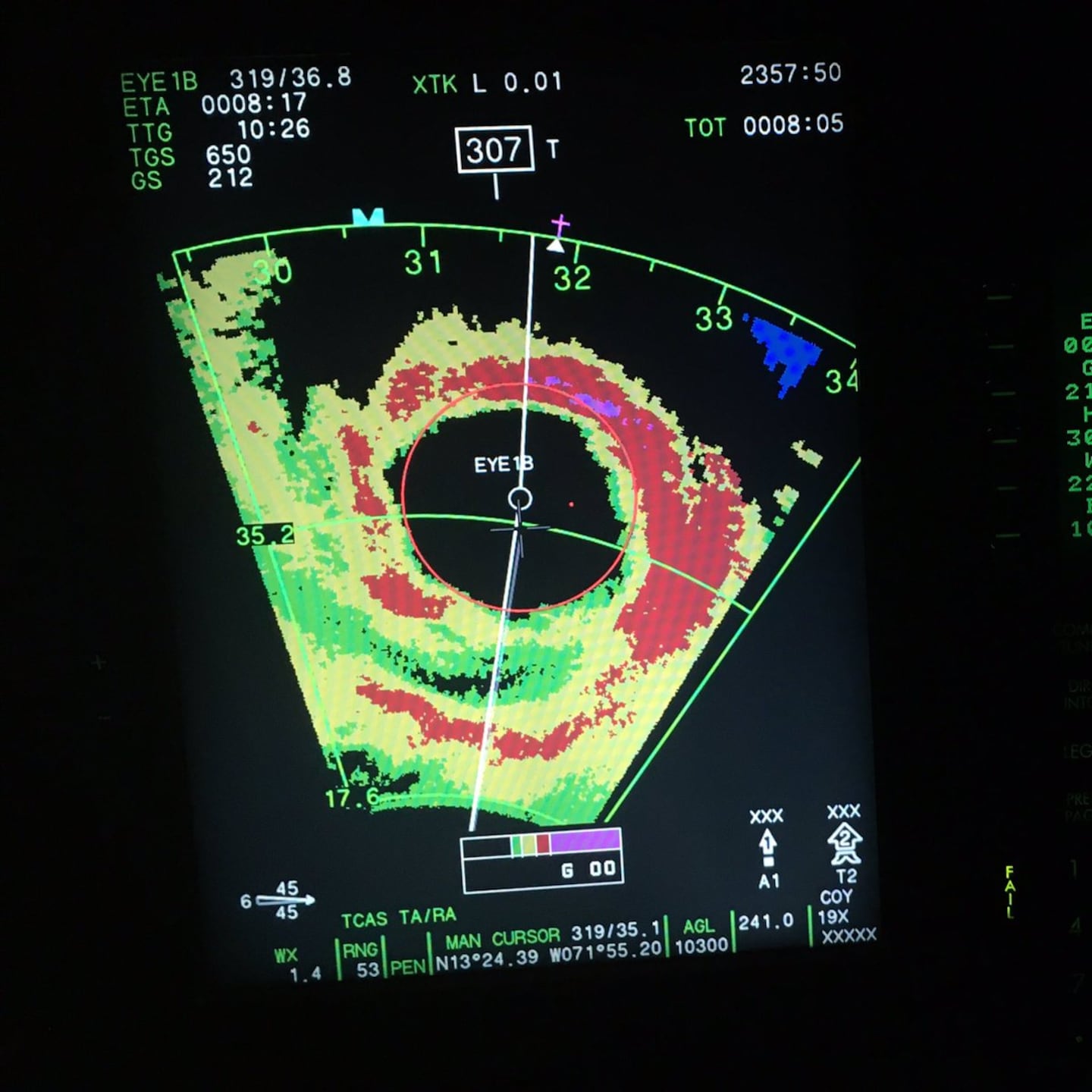
Hurricane hunter aircraft radar imagery when "Matthew" was Cat. 5!:
Concentric eyewalls on Oct. 4th:
0
The First Alert Action News "general" wind forecast:
1
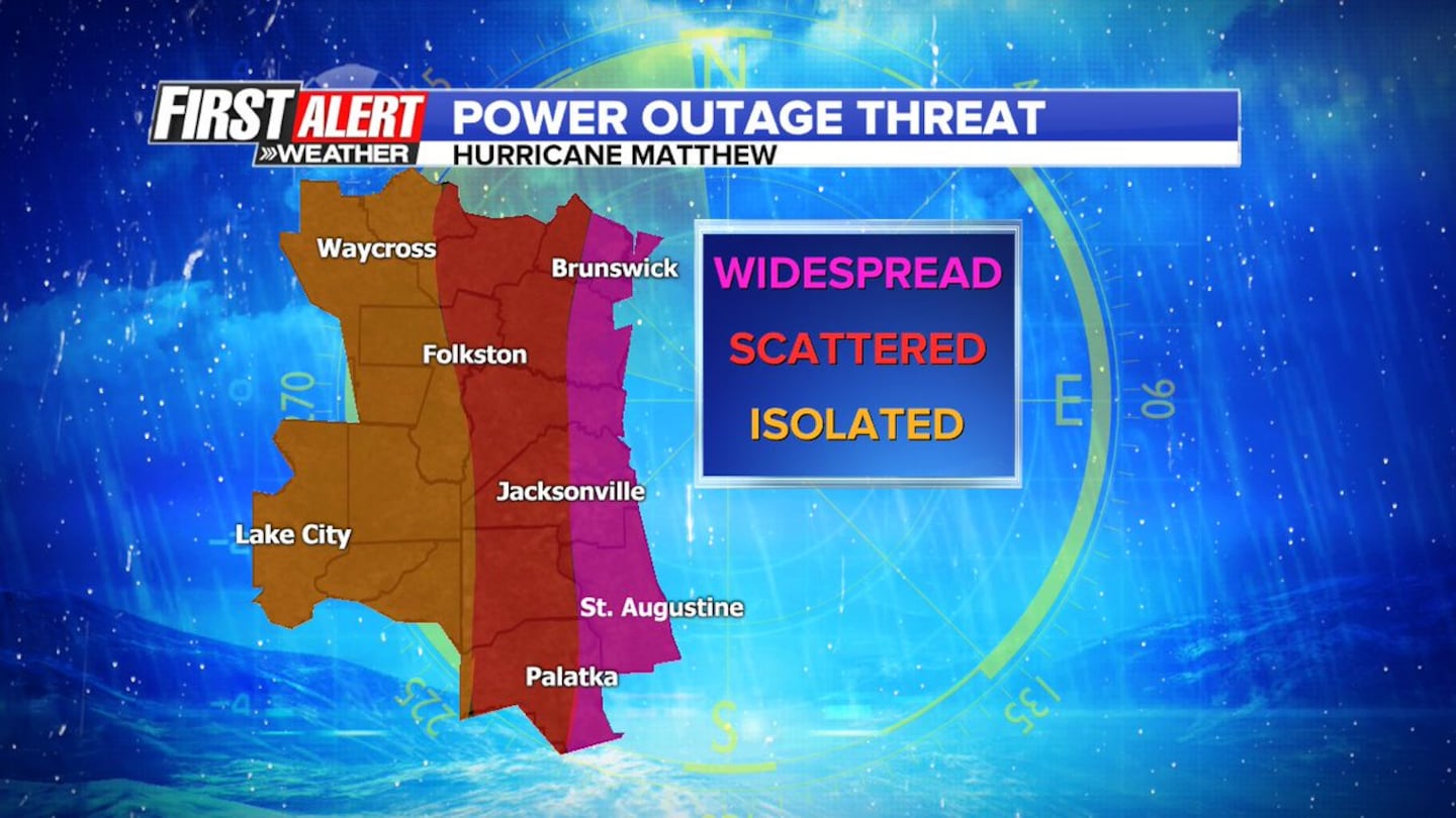
General power outage threat:
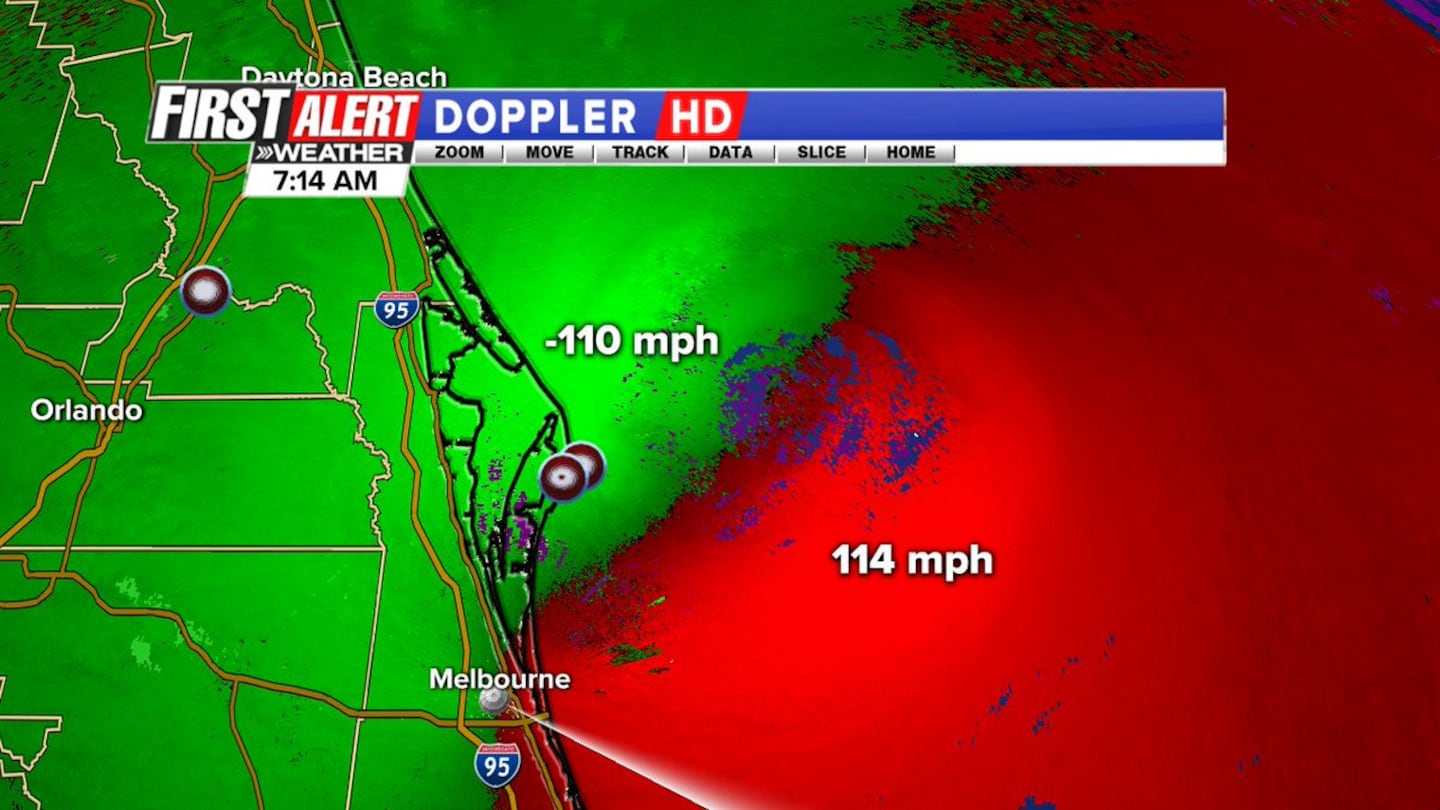
Fri. morning about 7:15am - First Alert Doppler HD radial velocities showing 100+ mph winds offshore:
Thoughtful platter from the Hyatt Regency Jacksonville Riverfront: (many in the newsroom brought the First Alert weather m'gists drinks &/or food. None seemed better than the very simply but delicious instant oatmeal that Paige Kelton whipped up for me about 7pm Fri. Swear it tasted like filet mignon :) )

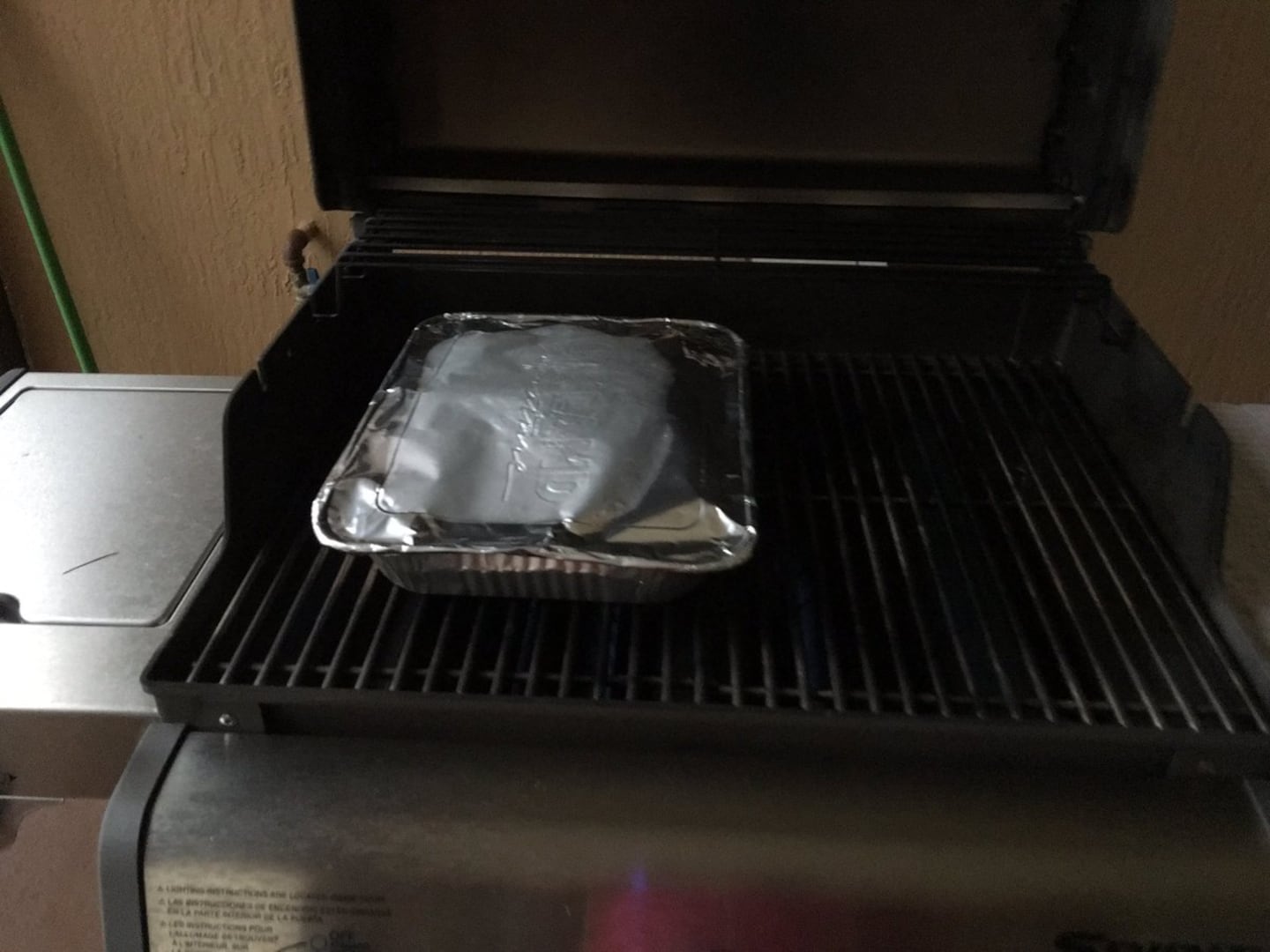
My wife heating up leftovers on the gas grill while the power is out:
News 1-0-4-5 WOKV Rich Jones pointed out in this tweet: "Can't recall seeing this from First Alert Chief Meteorologist Mike Buresh":
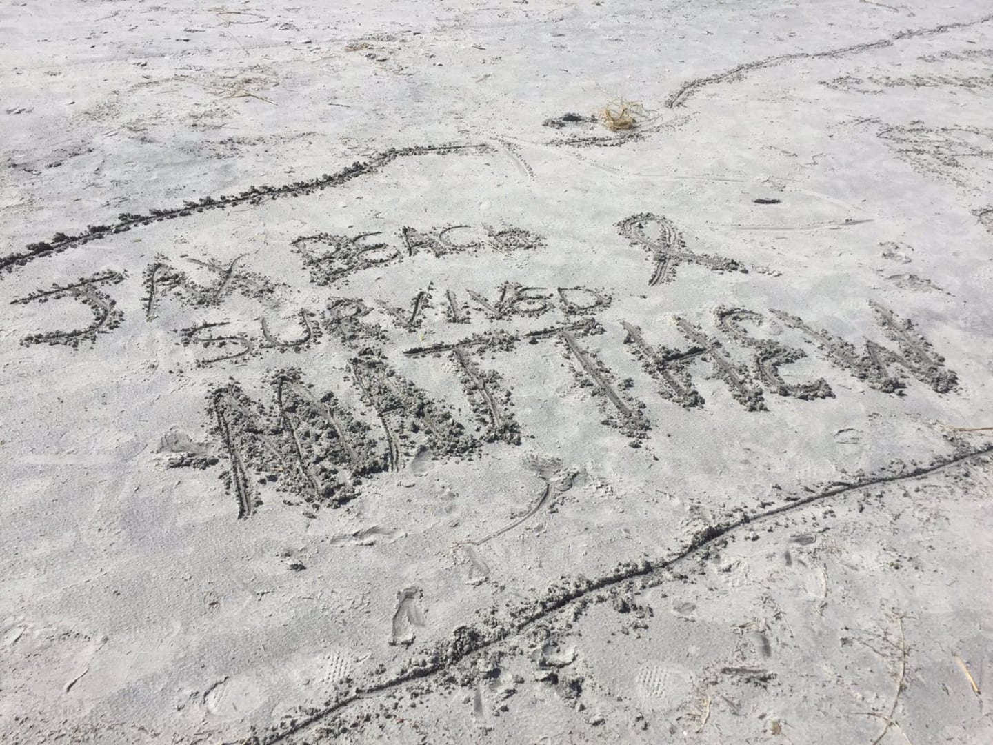
Jax Beach did fare better than many other beaches, especially to the south. This can at least partially be attributed to an outgoing tide (vs. high) & the distance (45+ miles) offshore.
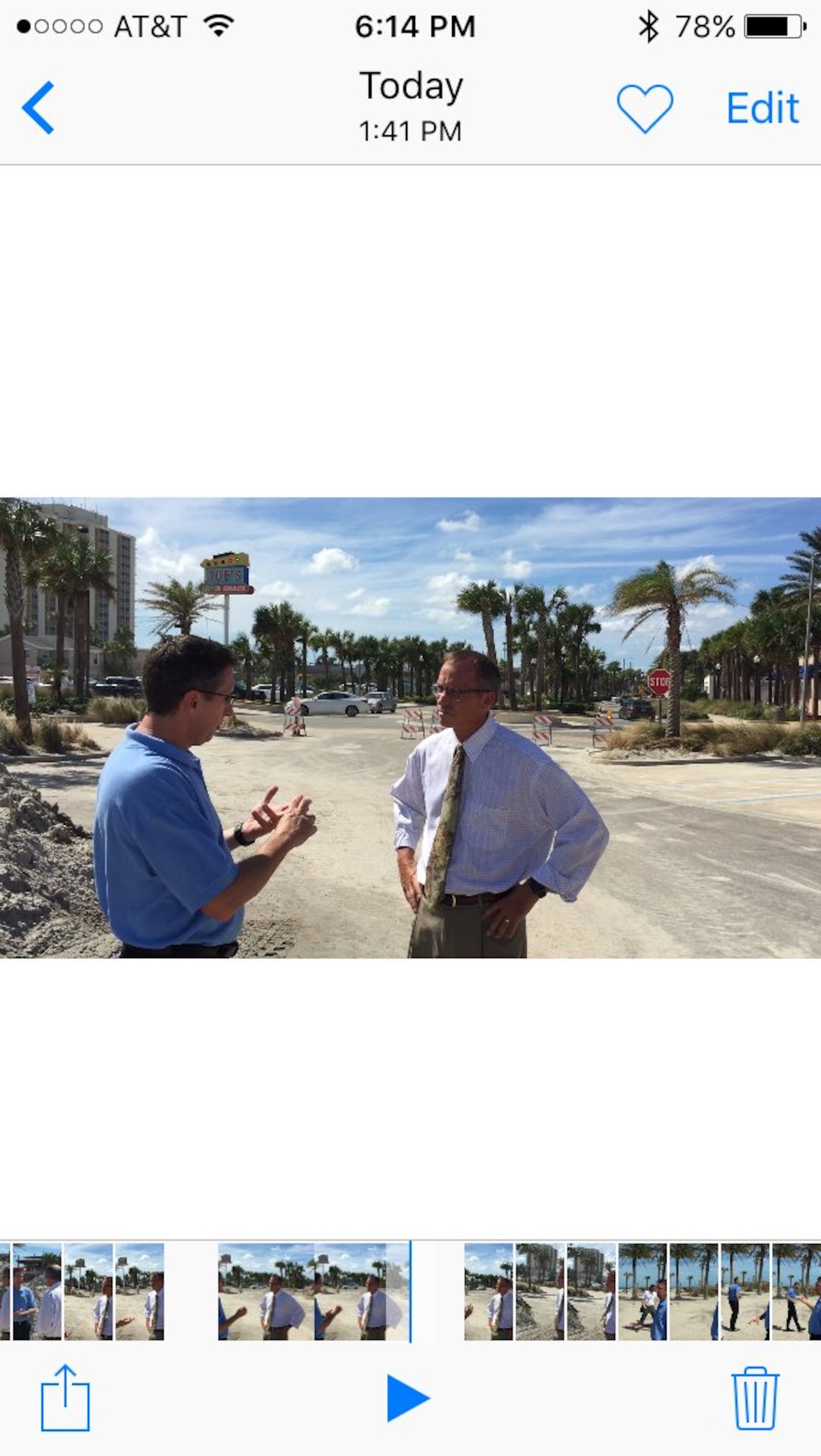
Talking with NHC Director, Dr.Rick Knabb Fri. afternoon, Oct. 14th:
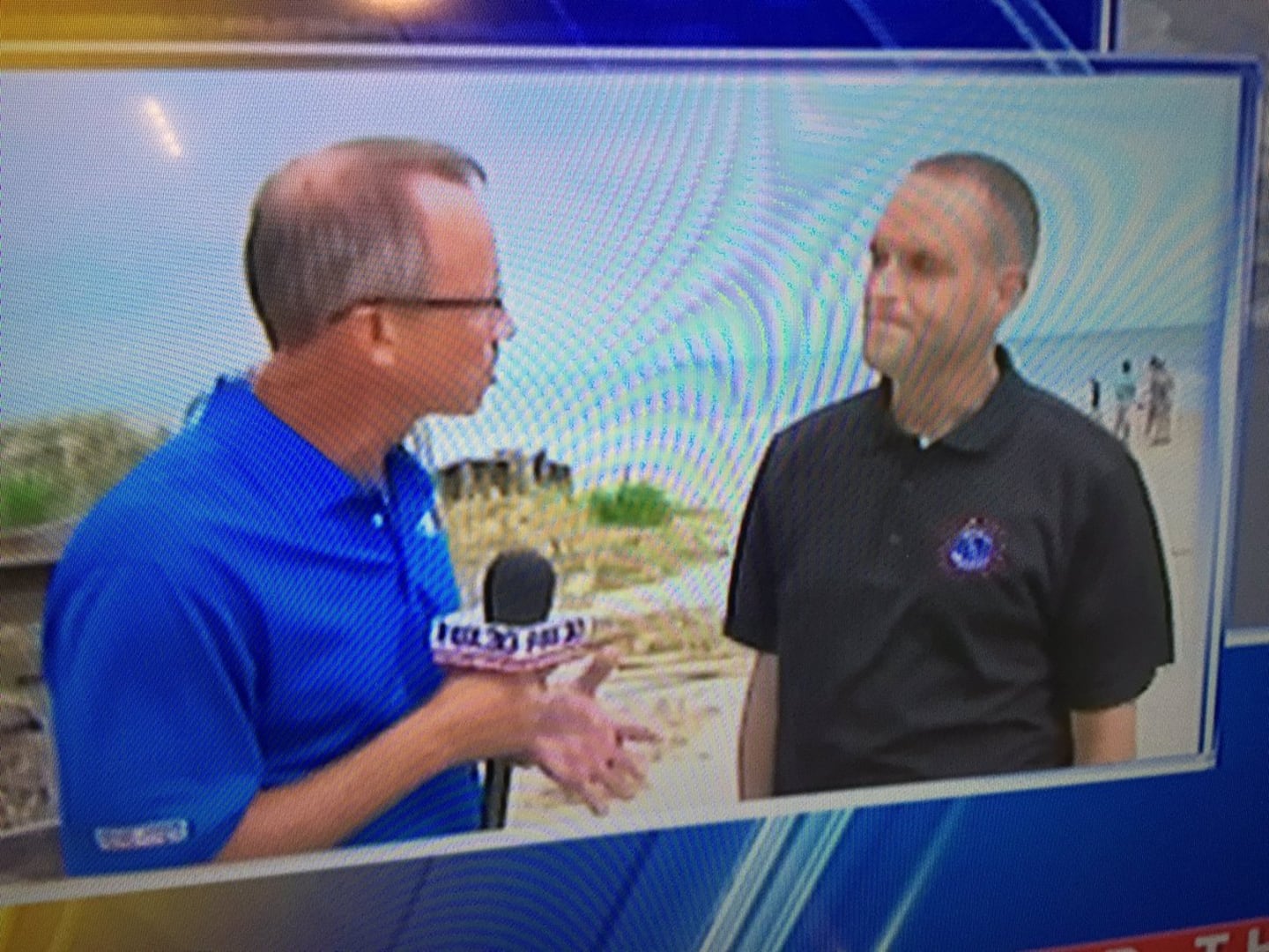
Quick unplanned interview with Jason Hess, Jax N.W.S.:
Surf Station, St. Augustine:
0
EverBank Field:
1
..... & last but not least.... a precious message from Khloe Guthrie :)
2
3
Cox Media Group


