
Jacksonville, FL — Daily updates on the tropics: “Talking the Tropics With Mike”.......
The first U.S. landfalling hurricane of the season was nothing short of a doozy. Depending on how one measures the Cat. 4 hurricane, Ida will go down as one of the top 5 strongest hurricanes to hit the U.S.
... It’s the 2nd lowest pressure for a Louisiana landfall (Katrina - #1)
... tied with the Last Island Hurricane of 1856 & Laura last year for the strongest winds - 150 mph sustained - for a Louisiana landfall
... since 1979, only 2 hurricanes have intensified faster - Allen in 1980 & Rita in 2005.
The 2 “major” hurricanes (Grace & Ida) by Aug. 29th in the Atlantic Basin hasn’t happened since 2005.
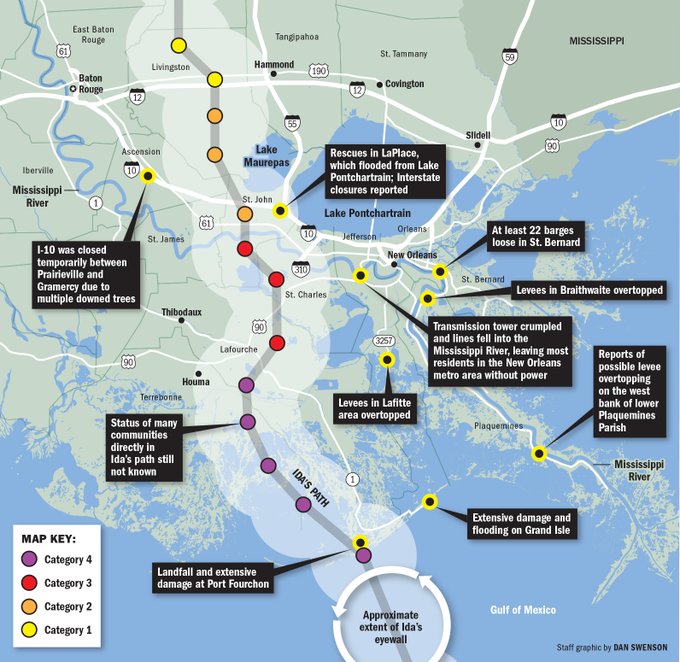
One has to be careful with measuring Ida’s impact by simply looking at the damage in New Orleans. This mistake was made in 2005 after Katrina. New Orleans did not even come close to feeling the brunt of Katrina’s wrath. The “after-flood” was a product of the failure of the levees. The devastated area was east of New Orleans along the extreme Southeast Louisiana coast & especially the Mississippi & Alabama coastlines. But New Orleans received a good deal of the publicity much to the chagrin of hard hit Waveland, Bay St. Louis, Pass Christian, Gulfport, Biloxi & Pascagoula. Ida was a more intense hurricane landfall (4 vs. Katrina’s 3) & the parish’s & communties from southeast through southwest of New Orleans truly experienced catastrophic damage. As it is, power will not be restored for quite some time in the Crescent City & perhaps not for at least weeks for some parts of Louisiana. In the end, the levee post-Katrina reconstruction - which cost billions of dollars - paid huge dividends during the greatest test yet for the newly fortified city.
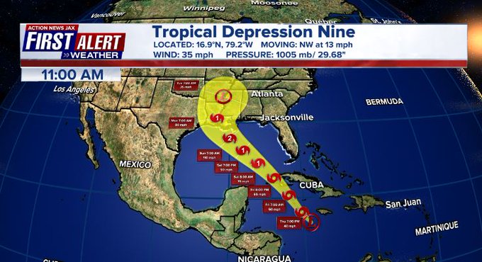
It also appears most folks heeded the warnings - first sounded as early as 4 days earlier - Wed., Aug. 25th - well before the storm even developed. In fact, forecasts were remarkably accurate including the usually tougher than ever intensity forecast. A storm like Ida just 20 years ago would have likely killed far more people... 40+ years ago perhaps scores of people would have lost their lives. The NHC & N.W.S. should be commended &, by the way, the GFS forecast model continues its stellar year of tropical cyclone forecasting. The image below shows the forecast from Thu. morning, the 26th for then t.d. #9 which would soon be “Ida” with an on-point landfall forecast (most closely following the GFS model). Intensity was too low at this point but was upped to Cat. 4 Friday & in subsequent forecasts.
A recap:
I “sounded the alarm” Wed. morning, Aug. 25th in “TTTWM” - here -. Ida was a tropical wave that originated off of Africa & has been steadily marching west waiting for a more favorable environment (less dust, more moist atmosphere & less shear). The system found that more favorable area & was upgraded to t.d. #9 Thu. morning then t.s. “Ida” late Thu.... & a hurricane early Fri. afternoon followed by a landfall on the Island of Youth then Western Cuba Fri. evening becoming a “major” hurricane overnight Saturday with a third & fourth landfall - & the first U.S. landfall early Sun. afternoon.
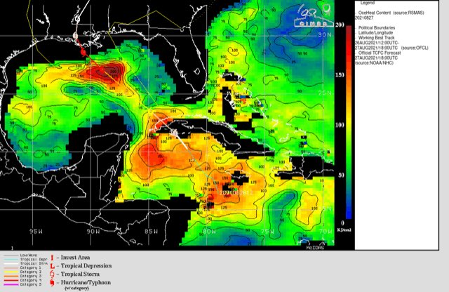
A warm “eddy” over the Gulf of Mexico - similar to 2005 [Katrina & Rita] - did indeed seem to help Ida intensify Sat. night/early Sunday during a classic rapid intensification cycle (RIC). The image below from CIMMS:
From online research paper w/ images by Michelle Mainelli...article: https://bit.ly/3BaAQoq - Katrina, 2005:
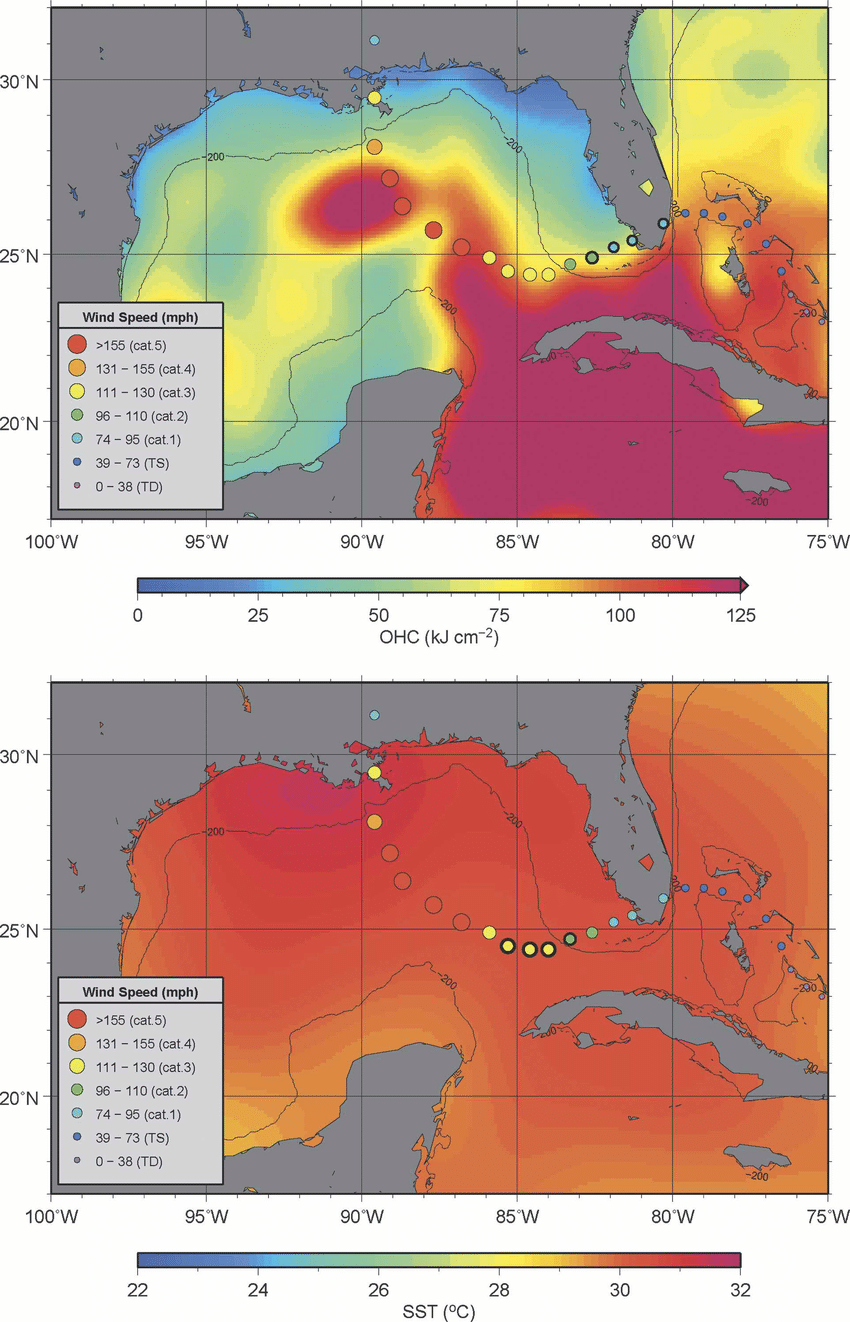
Despite fairly rapid movement - by tropical standards - Ida deepened fast within a moist atmosphere, low shear, strong upper level ventilation & warm water to develop into a major hurricane appearing to fall just short of Cat. 5 intensity (to be truly determined in post storm surveys & research). Ida was reminiscent of some of the most infamous U.S. landfalling hurricanes on record strengthening over a short period of time while approaching land: Laura, Michael, Andrew, Camille & the 1935 Labor Day hurricane to name just a few.
Ida continues the string of “bad luck” for Louisiana after 3 hurricanes & 1 tropical storm landfall last year in addition to tropical storm Claudette this year.
Double digit storm surge occurred just to the east of the eye where waves were measured at more than 40 feet! Dangerous storm surge occurred all the way east to Mobile, Al. with notable storm surge as far east as Pensacola, Fl. Much of New Orleans is essentially a bowl, so water would have been very slow to recede *but* much of the levee system - rebuilt after Katrina - held up to its biggest test since the reconstruction since 2005.
Rainfall of 1-2 feet on top of saturated ground added to the water/flooding woes.
Finally.... ‘I’ is rather notorious over the years & is the most retired letter of the Atlantic seasonal alphabet. Since 1955, there have been 11 ‘I’ names retired including Iris, Isidore, Isabel & Ivan in consecutive years from 2001-’04. Most recently Irma was retired in 2017 & Iota in 2020. Tied for second in retired letters is ‘C’ & ‘F’ with nine each.
From the ‘Times-Picayune’:
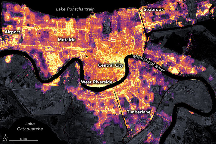
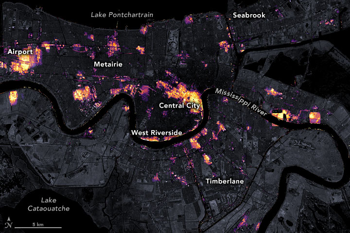
One of the biggest post Ida problems for New Orleans was power. The two images below show the extent of the loss of power during & after the hurricane:
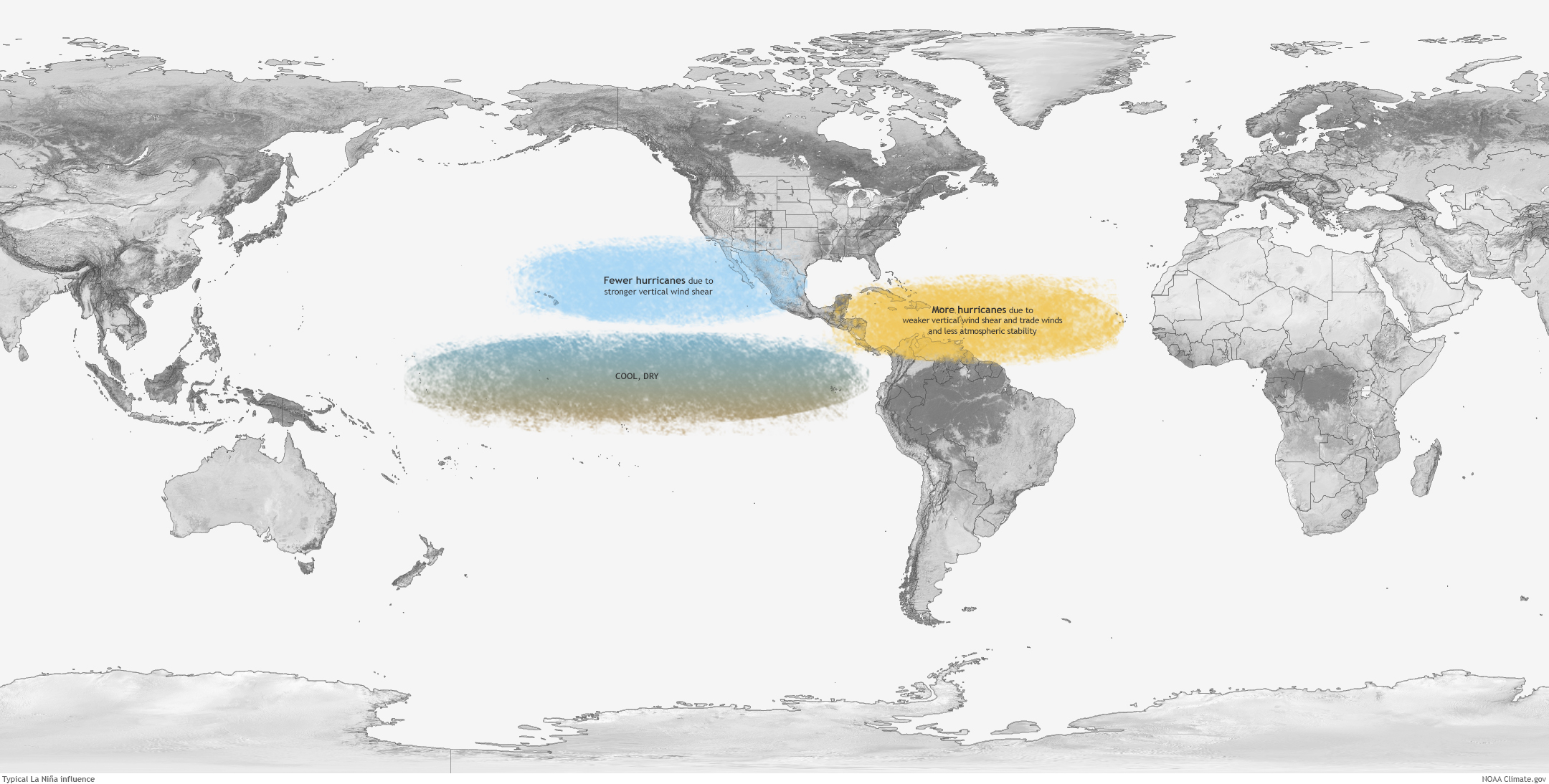
Part of the reason for the expected active 2021 hurricane season was tied to the potential for a 2nd consecutive year of La Nina which is a cooling of the equatorial Pacific water (though most of the season so far has been near neutral). NOAA is now predicting a 70% chance of a La Nina from Nov. - Jan. A trend toward La Nina conditions often correlates with less shear over the Atlantic Basin which can lead to more tropical storms & hurricanes, so we may be in for an active latter part of the hurricane season perhaps deep into Oct., even Nov. The majority of the forecast models below show a clear La Nina tendency:

Fewer Pacific tropical cyclones but more tropical storm/hurricane for the Atlantic Basin:

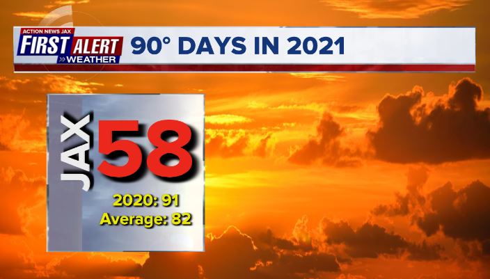
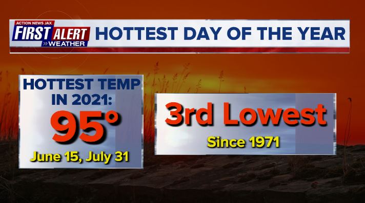
Well.... all summers in Jacksonville are going to be hot. But in the case of 2021, it could have been hotter(!). First of all - through Aug. 31st, there have “only” been 58 90-degree days this year so far. Way below the avg. of 82 days. Furthermore, the Jax N.W.S. reports that the hottest days so far - June 15th & July 31st at 95 degrees - is tied for the 3rd lowest hottest summer day going back to 1971 only beaten by 93 degrees in 1974 & 94 degrees in 2003.
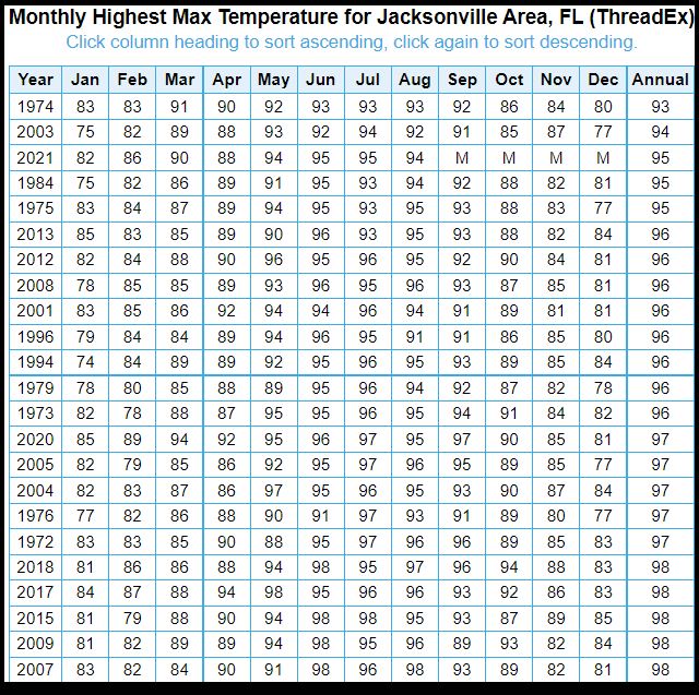
Jax N.W.S. table of summer “coolest” highest temps. since 1971:
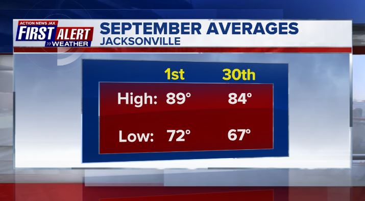
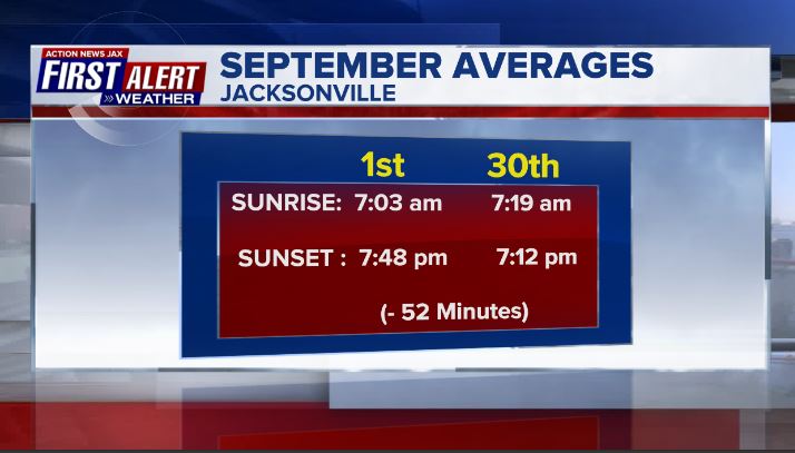
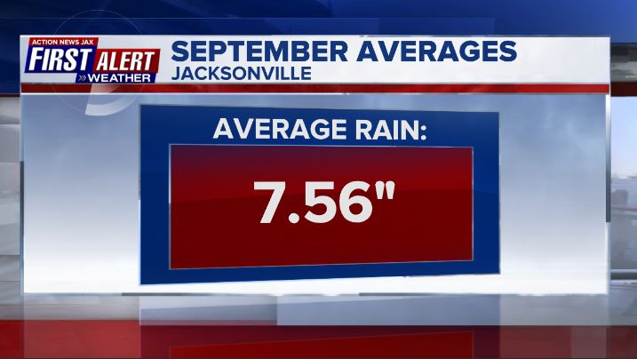
And so we turn our calendars to September with an eye on autumn. The JIA averages:
©2021 Cox Media Group


