Jacksonville, FL — Well... what’s new?! - the tropics continue on a torrid pace - at least the Atlantic Basin. “Talking the Tropics With Mike” is updated every day during the hurricane season.
So it’s pretty much a certainty that we’ll have to dive into the Greek alphabet for the first time since 2005 (used 6 Greek letters). Naming history * here * & * here (WMO) *Hurricane Sally made landfall just west of Pensacola, Fl. Wed., Sept. 16th & was the 8th named storm (in addition to Berth, Cristobal, Fay, Hanna, Isaias, Laura & Marco) to make a U.S. landfall this season breaking the record through Sept. 16th of 7 set in 1916. The record for an entire season was also in 1916 with 9 storms making a U.S. landfall during the hurricane season.
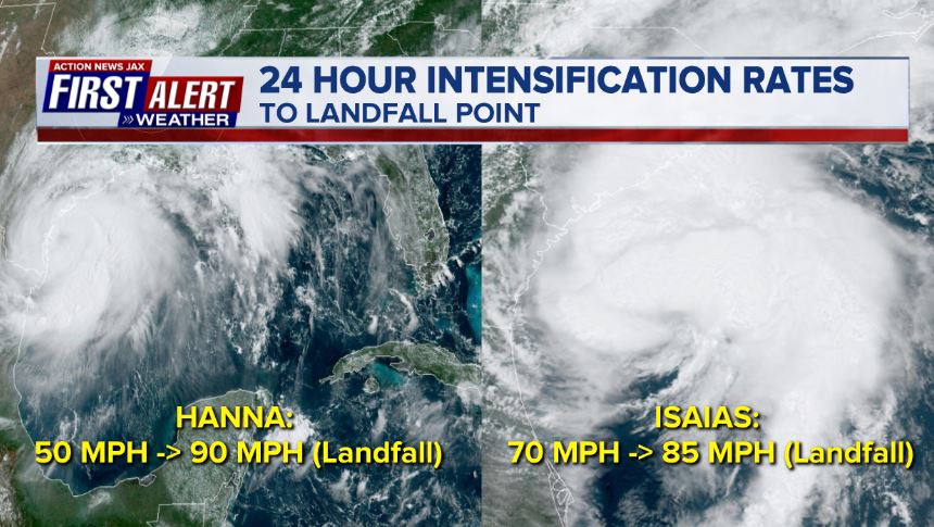
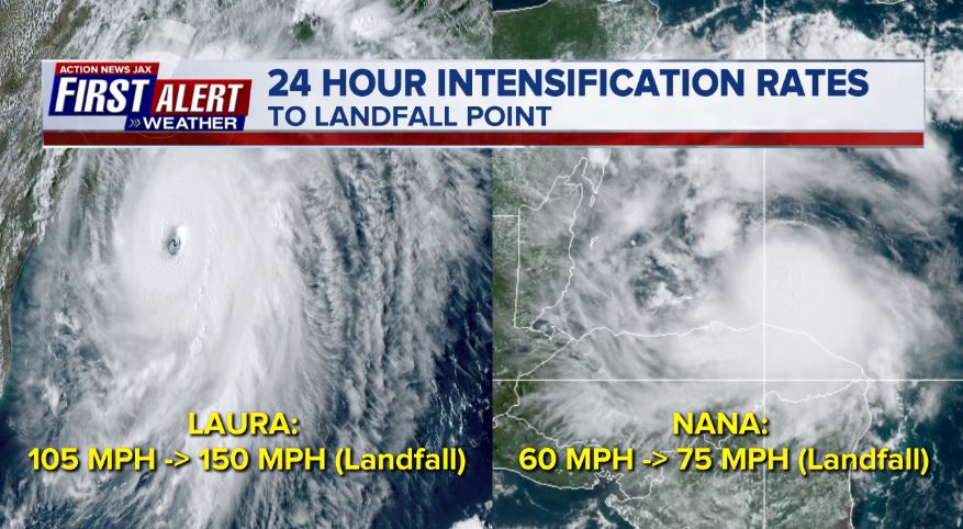
Also noteworthy is that a majority of the storms this season have strengthened upon approach to land which is a worst case scenario when it comes to destruction & human casualties.
Hanna landfall - South Texas... Isaias - N./S. Carolina:
Laura - Cameron, Louisiana.... Nana - Belize:
Paulette moved over Bermuda, Sally’s landfall was at Gulf Shores, Alabama:

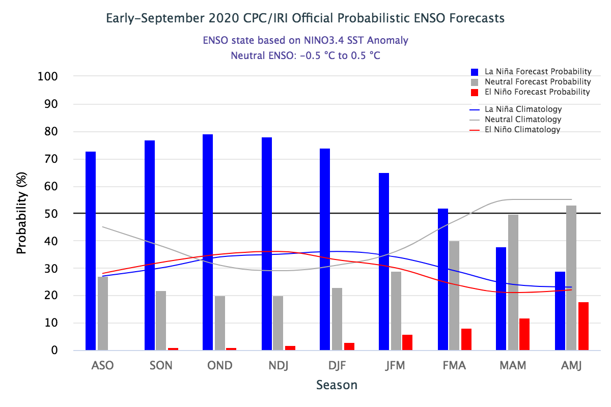
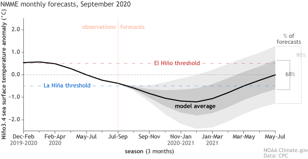
It’s no coincidence that our active Atlantic hurricane season coincides with a La Nina - warming of the ocean near the equatorial Pacific. The La Nina is one of the primary reasons for the robust forecasts before the season even began. So it was made “official” by NOAA that the La Nina is indeed underway having met the criteria: persistent colder-than-normal (0.5°C or greater) sea surface temperature (SST) anomalies across the central and eastern equatorial Pacific (170°W to 120°W longitude and 5°N to 5°S latitude).

Model forecasts indicate a strong potential for the La Nina to continue through the winter & probably - at least to some degree - into spring:
So we already know - & are living through - the active hurricane season. As for the future... IF the La Nina continues, winter for the U.S. is typically characterized by drier conditions across the South - including Fl. & most of Ga.... wetter Ohio Valley & Pacific Northwest... cold Northern Rockies & Upper Plains:

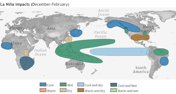
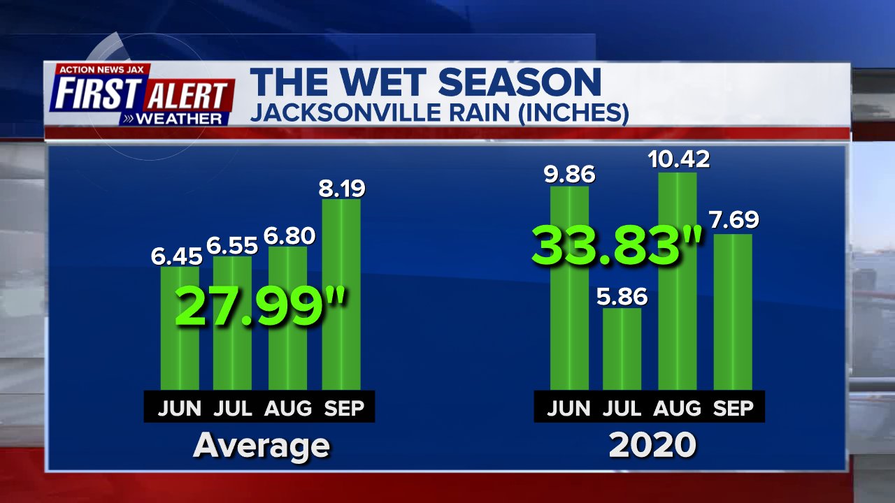
For Jacksonville/NE Fl./SE Ga., La Nina winters often have big temp. swings - including freezes - & are generally drier. So we may need all the moisture we can get heading into winter. So far, so good (through Sept. 17th):
The numbers are in on “meteorological” summer (June/July/Aug.). For Jacksonville, it was “only” seasonally hot & humid, just about right at average. But for much of the rest of the U.S. - & globe for that matter - it was sizzling - possibly the 2nd hottest on record.
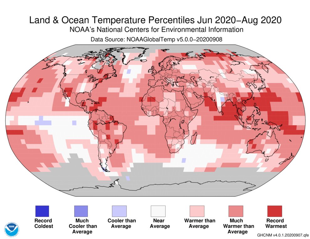
Nationally.... the past summer ended up as one of the hottest on record for SW Fl... much of the Northeast U.S. & parts of the SW while many areas had a top 10 hottest summer:

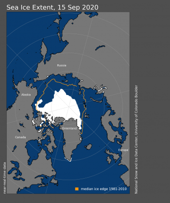
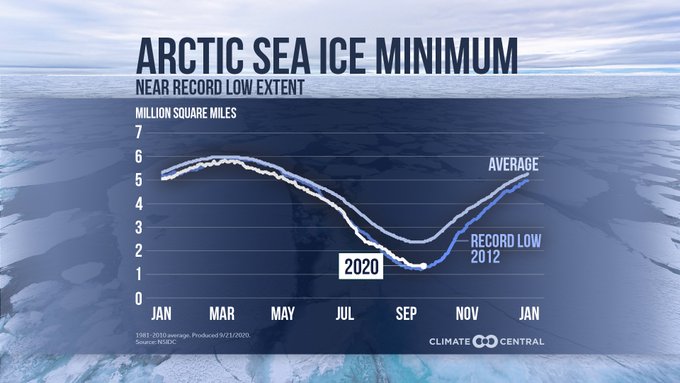
And Arctic summer sea ice melt is at its 2nd highest point on record:
· The 2020 minimum is about 969,000 square miles below the 1981-2010 average minimum extent, which is equivalent in size to roughly the states of Alaska, Texas, and Montana combined
· The 14 lowest extents in the satellite era (since the 1960s) have all occurred in the last 14 years
· The record lowest extent occurred in 2012
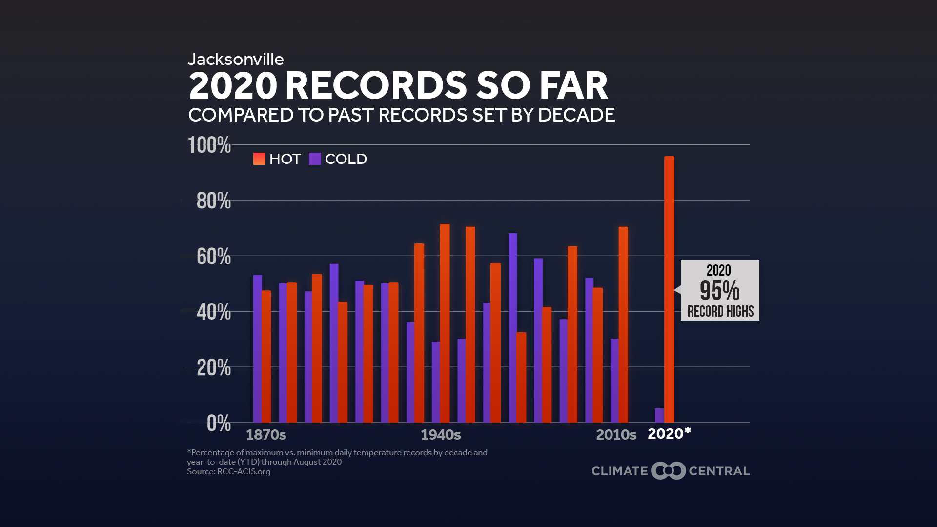
And an interesting trend - especially recently - when it comes to the number of record highs vs. record lows. There’s been a tilt toward more record highs since about 2010, but the difference has been especially dramatic this year with 95% of the record temps. being for daily highs or maximum lows.
Cox Media Group