JACKSONVILLE, Fla. — UPDATE 12:30 A.M. FRIDAY: Most of the severe weather has moved passed our area. There were many reports of damage all throughout Northeast Florida and Southeast Georgia.
First Alert Storm Update: Severe threat is over.... rest easy overnight :) @wokvnews #FirstAlertWx pic.twitter.com/3aDlz8qSg3
— Mike Buresh (@MikeFirstAlert) February 7, 2020
UPDATE 10 P.M. Severe Thunderstorm Warning still issued for Camden and Glynn counties in Georgia and Bradford, Clay, Duval, St. Johns, Putnam and Nassau, counties in Florida.
#firstalertwx INTENSE severe storm with HIGH winds will track through Jacksonville just after 10 PM @WOKVNews pic.twitter.com/f866dPVfni
— Mike Buresh (@MikeFirstAlert) February 7, 2020
UPDATE 8:50 P.M. - Tornado warning in effect for northern portions of Columbia County and parts of Baker County.
Severe Thunderstorm Warning still issued for Brantley, Camden, Charlton, Ware and Glynn counties in Georgia and Baker, Bradford, Clay, Duval, Nassau, Putnam and Union counties in Florida.
You can find the Breaking Stream here: https://www.actionnewsjax.com/live-breaking/
TORNADO WARNING for northern Baker & Columbia #FirstAlertWX @WOKVNews pic.twitter.com/qRFbKSSHRW
— Mike Buresh (@MikeFirstAlert) February 7, 2020
Facebook live:
TIGHT and brief circulation that prompted tornado warning for northern Columbia/Baker just before 9 PM on Thursday. Green = wind toward the radar, Red = wind away from the radar (which is by Valdosta, GA) #FirstAlertWX pic.twitter.com/fJwV9u9fDC
— Corey Simma (@CSimmaWX) February 7, 2020
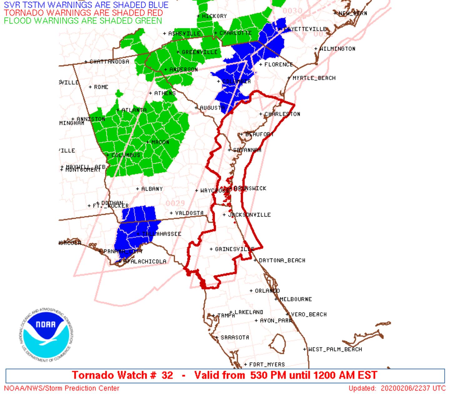
UPDATE 5:30 p.m.: Parts of our viewing area are under a tornado watch until midnight tonight.
UPDATE 12:30 p.m.: According to the First Alert Weather team, there are current tornado watches for Ware County, GA, Pierce County, GA, Brantley County, GA, Baker County, FL, Columbia County, FL, Charlton County, GA. until 8 p.m. Thursday night.
STAY INFORMED: Get instant severe weather alerts and video updates from the First Alert Weather team by downloading the free First Alert Weather app. Click here to download.
WHAT TO EXPECT DURING THE DAY:
We are starting off Thursday mild with temperatures in the 60s. We will see partly cloudy skies this morning. More clouds will build in throughout the day. Highs will soar to the lower 80s this afternoon.
First Alert Chief Meteorologist Mike Buresh is tracking when storms arrive in our area on CBS47 and FOX30 | Click here to watch live
We will be near record highs (85 – 2008). A Wind Advisory will go into effect today at noon to 3 a.m. for all Jacksonville-area counties.
In addition to a windy day, a few showers are possible this afternoon for some local neighborhoods.
WHAT TO EXPECT TONIGHT:
A First Alert Weather Day will go into effect tonight. A line of potentially strong to severe storms will move into the area this evening from west to east. The main threats are brief heavy rain, gusty winds of 50-60 mph+, and an isolated tornado.
Some schools will close early today ahead of the severe weather.
RELATED: Buresh Blog | Jacksonville Hour By Hour | Download the free First Alert Weather app
Friday’s morning commute will be mainly dry and breezy with some leftover wet roadways.
STAY INFORMED: Get instant severe weather alerts and video updates from the First Alert Weather team by downloading the free First Alert Weather app. Click here to download.
You can also watch any severe weather coverage live if you are away from a TV on the app.
TONIGHT | We are tracking a line of strong storms that will moving generally west to east across our area. Here are some of the latest details. Be "weather aware" tonight and have a way to get warnings! Download: https://t.co/ZDQFQdVHzv #FirstAlertWX pic.twitter.com/kXkPBGs7Aj
— Garrett Bedenbaugh (@wxgarrett) February 6, 2020
We could see a few power outages tonight as winds ahead of the cold front will be gusting to 35-40+ mph. The line of storms will be potentially producing damaging wind gusts of 50-60 mph. https://t.co/ZDQFQdVHzv @wokvnews @actionnewsjax #FirstAlertWX pic.twitter.com/nPc0yPusAe
— Garrett Bedenbaugh (@wxgarrett) February 6, 2020
© 2020 Cox Media Group


