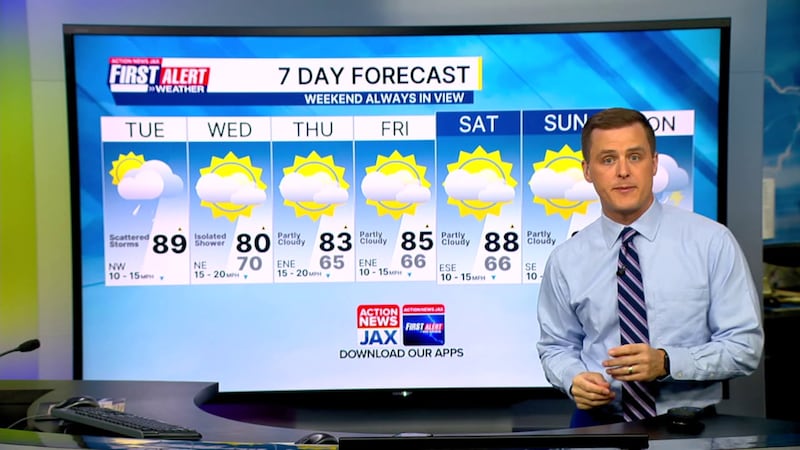
- This morning is mild with temperatures in the 70s under partly cloudy skies.
- It will be another hot and humid day with temperatures rising into the upper 80s/lower 90s inland and lower to mid 80s along the coast.
- We will track afternoon thunderstorms developing between 1 p.m. and 3 p.m. as a front moves into the area, as well as afternoon sea breezes.
- Highest risk for afternoon storms will be in near and south of I-10.
- An isolated afternoon storm is possible in SE Georgia.
- A few gusty winds are possible with any of the thunderstorms.
- An additional 1-2 inches of rain is possible, especially in NE Florida, through this evening.
- Unseasonably dry air will push into the area starting tomorrow, shutting off rain chances and dropping humidity.
- Mornings will feel comfortable with temperatures in the 60s.
- The weekend looks great, weather wise.
JACKSONVILLE, Fla. — TROPICS: No areas of concern.
TODAY: Partly cloudy with heavy afternoon showers/storms. HIGH: 89
TONIGHT: Showers and storms early, clearing late. LOW: 70
WEDNESDAY: Partly to mostly sunny, breezy, isolated shower. 65/80
THURSDAY: Mostly sunny and nice. 65/83
FRIDAY: Mostly sunny. 66/85
SATURDAY: Mostly sunny. 66/88
SUNDAY: Mostly sunny. 67/89
MONDAY: Partly cloudy, afternoon shower/storm. 68/90
WATCH THE FORECAST | DOWNLOAD THE APPS
Follow Action News Jax Meteorologists on Twitter for updates:
Mike Buresh | Garrett Bedenbaugh | Corey Simma | Trevor Gibbs
ALLERGY TRACKER: See what the pollen counts look like in our area
LISTEN: Mike Buresh ‘All the Weather, All the Time’ Podcast
INTERACTIVE RADAR: Keep track of the rain as it moves through your neighborhood
SHARE WITH US: Send us photos of the weather you’re seeing in your area ⬇️


