JACKSONVILLE, Fla. — The Action News Jax First Alert Weather Team is tracking a few showers and storms that will continue to develop this afternoon from the St. Johns River to the coast.
Notes from the meteorologist:
- Heavy downpours, lightning and a few gusty winds will be embedded in the storms as they move generally east.
- A few lingering showers/storms are possible this evening through 9-10 pm inland.
- Wednesday morning commute will be mild and muggy.
- Scattered showers and storms will shift more inland tomorrow afternoon as the Atlantic sea breeze is able to move farther west.
- Daily summertime thunderstorms will continue through the rest of the week, focusing inland.
TROPICS:
- No areas of concern.
INTERACTIVE RADAR: Keep track of the rain as it moves through your neighborhood
WATCH THE FORECAST | DOWNLOAD THE APPS
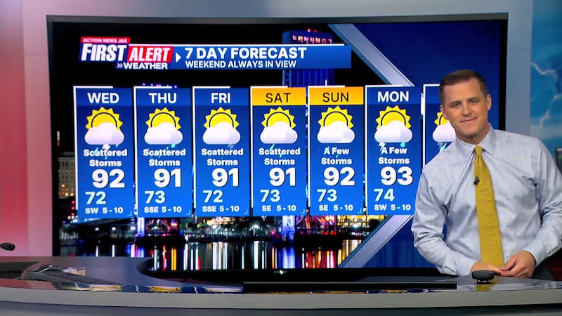
First Alert 7-Day Forecast:
- TONIGHT: Mostly cloudy with a few inland showers/storms early. LOW: 72
- TOMORROW: Partly sunny. Scattered afternoon showers and storms shifting inland. High: 92
- THURSDAY: Partly cloudy with scattered inland storms. 73/91
- FRIDAY: Partly cloudy with a few inland storms. 72/91
- SATURDAY: Partly cloudy with a few inland storms. 73/91
- SUNDAY: Partly cloudy with a few storms. 73/92
- MONDAY: Partly cloudy with a few afternoon storms.74/93
- TUESDAY: Partly sunny with a few afternoon storms. 74/93
Follow Action News Jax Meteorologists on Twitter for updates:
Mike Buresh | Garrett Bedenbaugh | Corey Simma | Trevor Gibbs
SHARE WITH US: Send us photos of the weather you’re seeing in your area ⬇️


