JACKSONVILLE, Fla. — This morning is warm and humid with temperatures in the 70s.
- Today will be another very hot day with highs rising into the lower to middle 90s. Feels like temperatures will be 100-105F this afternoon.
- Showers and thunderstorms should develop across the area by early to mid-afternoon, quickly dropping temperatures in the process.
- Storms will be moving from west to east today.
- Storm hazards today will be similar to yesterday: Very heavy rain, lightning, and strong gusty winds.
- The week ahead will be unsettled and summer-like: Hot and humid each day with decent coverage of mainly afternoon/evening showers and thunderstorms, especially Monday and Tuesday.
- All neighborhoods should receive beneficial rain over the next week, with some localized spots receiving 1-2+ inches wherever thunderstorms repeat.
TROPICS:
- No active storms.
- One area to watch near the TX/LA coastline for low-end tropical development this week.
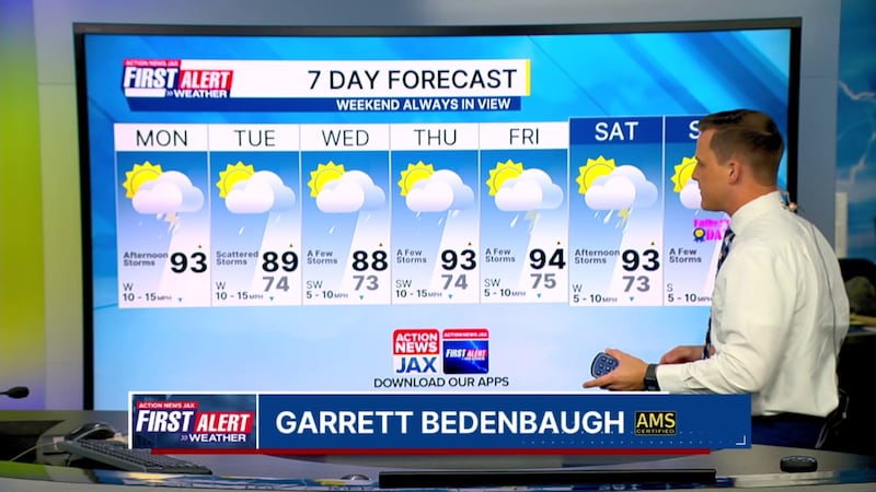
TODAY: Hot and humid, afternoon/evening showers and storms. HIGH: 93 (Feels like 100-105)
TONIGHT: A few storms early, then partly cloudy and humid. LOW: 74
TUESDAY: Mostly cloudy, scattered showers and storms. 74/89
WEDNESDAY: Partly cloudy, a few storms. 73/88
THURSDAY: Partly cloudy and hotter, a few storms. 74/93
FRIDAY: Partly cloudy and hot, a few storms. 75/94
SATURDAY: Partly cloudy and hot, a few storms. 73/93
SUNDAY: Partly cloudy and hit, a few storms. 73/91

WATCH THE FORECAST | DOWNLOAD THE APPS
Follow Action News Jax Meteorologists on Twitter for updates:
Mike Buresh | Garrett Bedenbaugh | Corey Simma | Trevor Gibbs
ALLERGY TRACKER: See what the pollen counts look like in our area
LISTEN: Mike Buresh ‘All the Weather, All the Time’ Podcast
INTERACTIVE RADAR: Keep track of the rain as it moves through your neighborhood
SHARE WITH US: Send us photos of the weather you’re seeing in your area ⬇️


