JACKSONVILLE, Fla. — Here’s what the First Alert Weather Team said you can expect for the First Alert Weather forecast:
- It’s another mostly sunny and breezy day, but pretty fantastic otherwise
- Tonight’s comfortable inland with temperatures dropping to the low 60s
- Onshore winds continue this week
- Winds may let up a little mid-week before breezing up again by the weekend
- We can’t rule out an isolated shower near & west of I-95 Monday afternoon
- But it’s a largely dry day, and a largely dry week
- Temperatures, both morning & afternoon, stay below average most of the week
- Showers are trying to work their way back into the area by the weekend
WATCH THE FORECAST | DOWNLOAD THE APPS
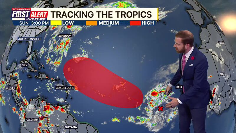
Tropics:
- A tropical wave in the East/Central Atlantic is tracking westward
- This thing may indeed be the next depression or named storm
- The next named storm will be “Gabrielle”
- Long-range forecasts keep this system out over the ocean
- It appears there is no tropical threat to Florida for the next week and potentially beyond
Follow Action News Jax Meteorologists on Twitter for updates:
Mike Buresh | Garrett Bedenbaugh | Corey Simma | Trevor Gibbs
First Alert 7-day Forecast:
- TONIGHT: Partly Cloudy & Breezy. Low: 65
- TOMORROW: Partly Cloudy & Breezy, Isolated Shower. High: 87
- TUE: Partly Cloudy & Breezy. 65/86
- WED: Partly to Mostly Sunny. 67/86
- THU: Partly Cloudy. 68/86
- FRI: Partly Sunny. 68/87
- SAT: Partly Cloudy, Isolated Shower. 69/89
- SUN: Partly Cloudy & Breezy, A Few Showers. 70/88