
Aug. 31, 2017 — "Irma" over E. Atlantic + eye on Western Gulf (again!).......
The "Buresh Bottom Line" is: stay tuned!... Always be prepared!..... City of Jacksonville Preparedness Guide... Georgia Hurricane Guide.
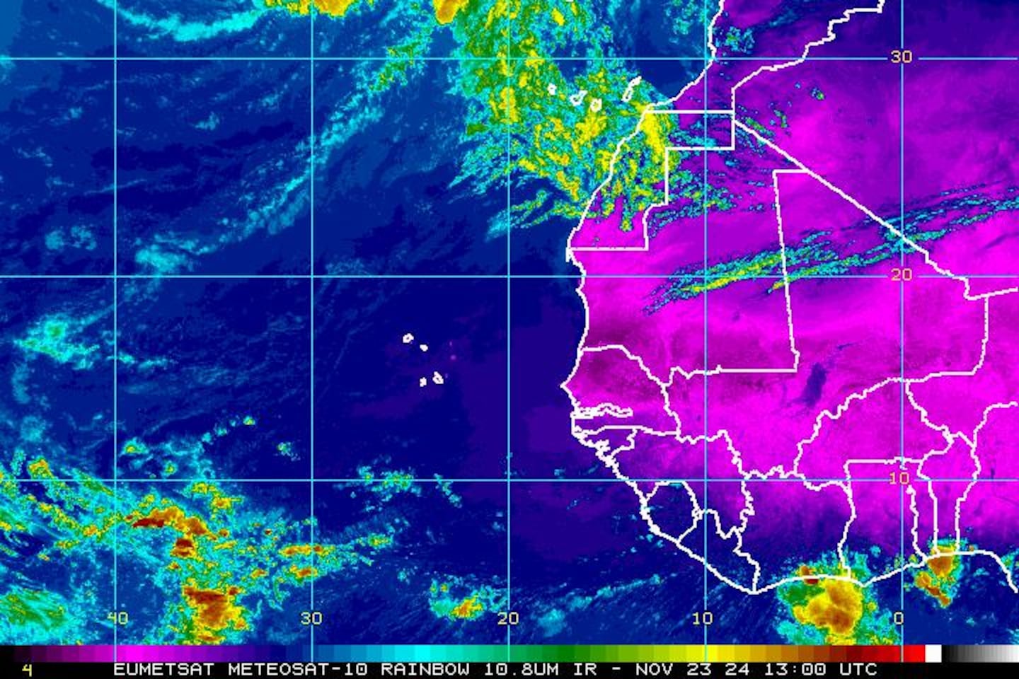
East Atlantic -- as we head into the peak of the Cabo (Cape) Verde season, waves are rolling west off Africa. "Irma" was one such wave & has the potential to be a classic deep tropics long track (trans-Atlantic) hurricane. As would be expected at this early juncture, forecast models are all over the place - especially with regards to location in the long run. It would be prudent to not hang on each & every individual model run but rather look at the bigger picture in the coming days. There are some long range global forecast models that this cyclone well into the W. Atlantic by the middle of next week - close to the NE Caribbean Islands including Puerto Rico while other models show a more northward turn earlier. I can say this potential storm will stay away from the U.S. & any land areas through Labor Day. Any building/movement &/or strengthening of the Bermuda High - which has been a strong mainstay for months - makes storm recurvature more difficult. There will also be a rather deep upper level trough that moves into the Eastern U.S. next week which looks like it will play a role in the eventual movement of what should become powerful hurricane "Irma".
I am also keeping a watchful eye on the Western Gulf of Mexico (yet again!) as indications are that low pressure will try to develop over the Western Gulf next week. Whether or not this becomes a tropical system, the pattern could produce more heavy rain for parts of the Gulf Coast - thinking the middle & end of next week.


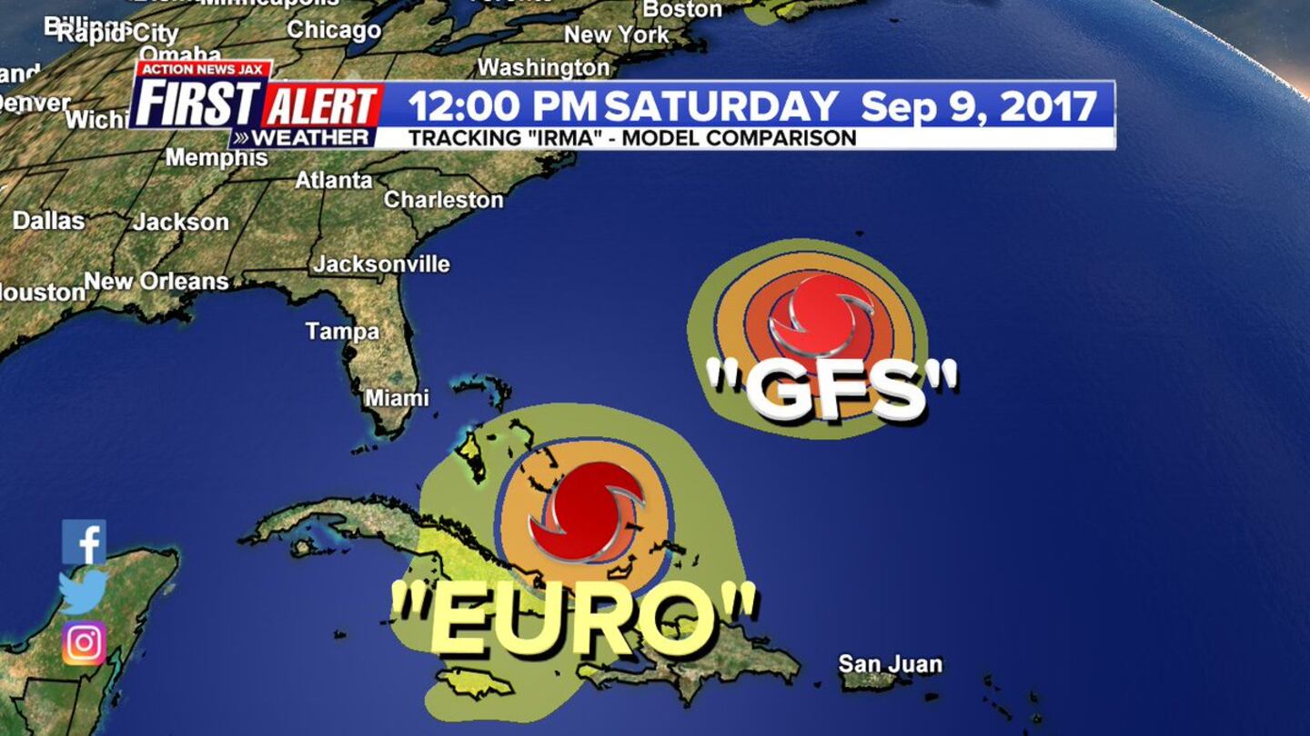
The image below for the GFS & European models for noon Sat., Sept. 9th illustrates the differences in forecast models. The GFS generally has shown an earlier turn north with an intense hurricane that stays east of Fl.... the European model has been much farther south & especially west & a bit slower but generally equally strong. The ultimate track will depend on what looks like a "trough split" over the Eastern U.S. which should eventually pull "irma" at least somewhat northward in time. Anyone from the Caribbean to the Gulf to the Eastern U.S. needs to be aware of future forecasts & realize preparation & a calm nerve are keys to smoothly dealing with possible storms.
"Irma" model plots:

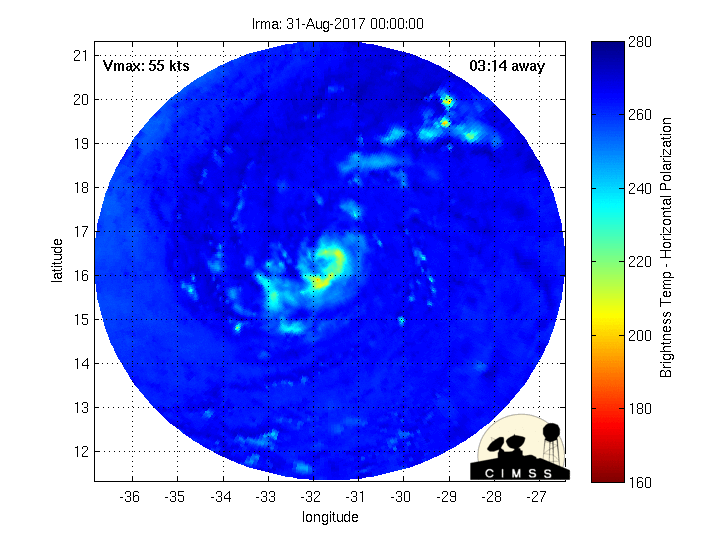
Fascinating imagery(!) from CIMMS, University of Wisconsin, Madison - Microwave radar-simulated imagery... click here for full definition..... note the bright colors overnight Tue. which coincided with tremendous rainfall rates in the Beaumont/Port Arthur area as Harvey made another landfall....

Horrible & historic "Harvey" - see "Buresh Blog" for some pics & further perspective - roared ashore as a powerful Cat. 4 hurricane Fri. evening about 11pm EDT near Rockport about 30-35 miles NE of Corpus Christi. This track spared Corpus Christi from extreme damage but torrential rain & flooding have stolen the headlines since Fri. Harvey was the first "major" U.S. landfalling hurricane since Cat. 3 "Wilma" slammed South Florida in Oct., 2005 - that's longest such stretch on record.... & was the first U.S. Cat. 4 landfall since "Charley" in 2004 which hit the west coast of Florida (Punta Gorda). The 938mb pressure is the 6th lowest on record for a Texas landfalling hurricane (Klotzbach). It is my humble opinion that while the death toll may not end up as high as hurricane Katrina in 2005.... nor was the storm surge as severe, most other measurements (meteorologically, property damage) will exceed Katrina.
Harvey made a third landfall (there were technically two landfalls Fri. night along the Texas coast/intracoastal) near the La./Tx. border early Wed. as a weak - but WET - tropical storm. The center will slowly move north then pick up speed & move more northeast while weakening through Fri. Heavy rain & isolated tornadoes will continue to accompany the system as far north as the Tennessee & Ohio Valley's though total rainfall amounts will not be as great as the past several days due to a combination of weakening & a little faster movement.
"Harvey" will stay far to the west & northwest of Florida so no direct impacts on Jacksonville though trailing moisture & weak disturbances + an upper level trough will enhance rainfall Fri. into Sat.
While the exact death toll is still not known.... It should be noted that the NHC & local NWS offices in Texas & Louisiana should be commended on excellent forecasts & warnings well in advance of "Harvey" including as the storm moved off the Yucatan Peninsula when the system looked so minor & meager. I believe this might be one of the best, most accurate forecasts in modern history regarding a big hurricane that hit the U.S. - especially considering the system was little more than a wave/weak low pressure system when moving off the Yucatan Peninsula .... offering us some hope when it comes to the ever perplexing tropical intensity forecast. A storm with this "personality" years ago would have killed scores. Having said that.... obviously the toll is severe & epic for what is statistcally a once in a lifetime storm.

Lake Charles, LA NWS Doppler radar loop:


0
1

Spaghetti plot for "Harvey":

Satellite imagery below shows a strong ocean storm over the NW Atlantic which is softening the western Bermuda ridge for the time being. The question becomes how long will it be before the ridge tries to build back to the west....

Tropical cyclone formation probability over next 1 - 2 days:

Wind shear analysis (red is stronger shear):

Water vapor imagery:

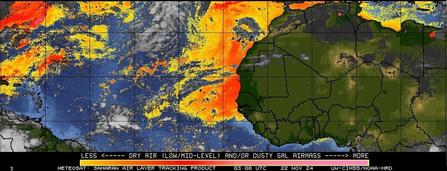
Imagery below courtesy CIMMS shows African Saharan dust (orange & red)....
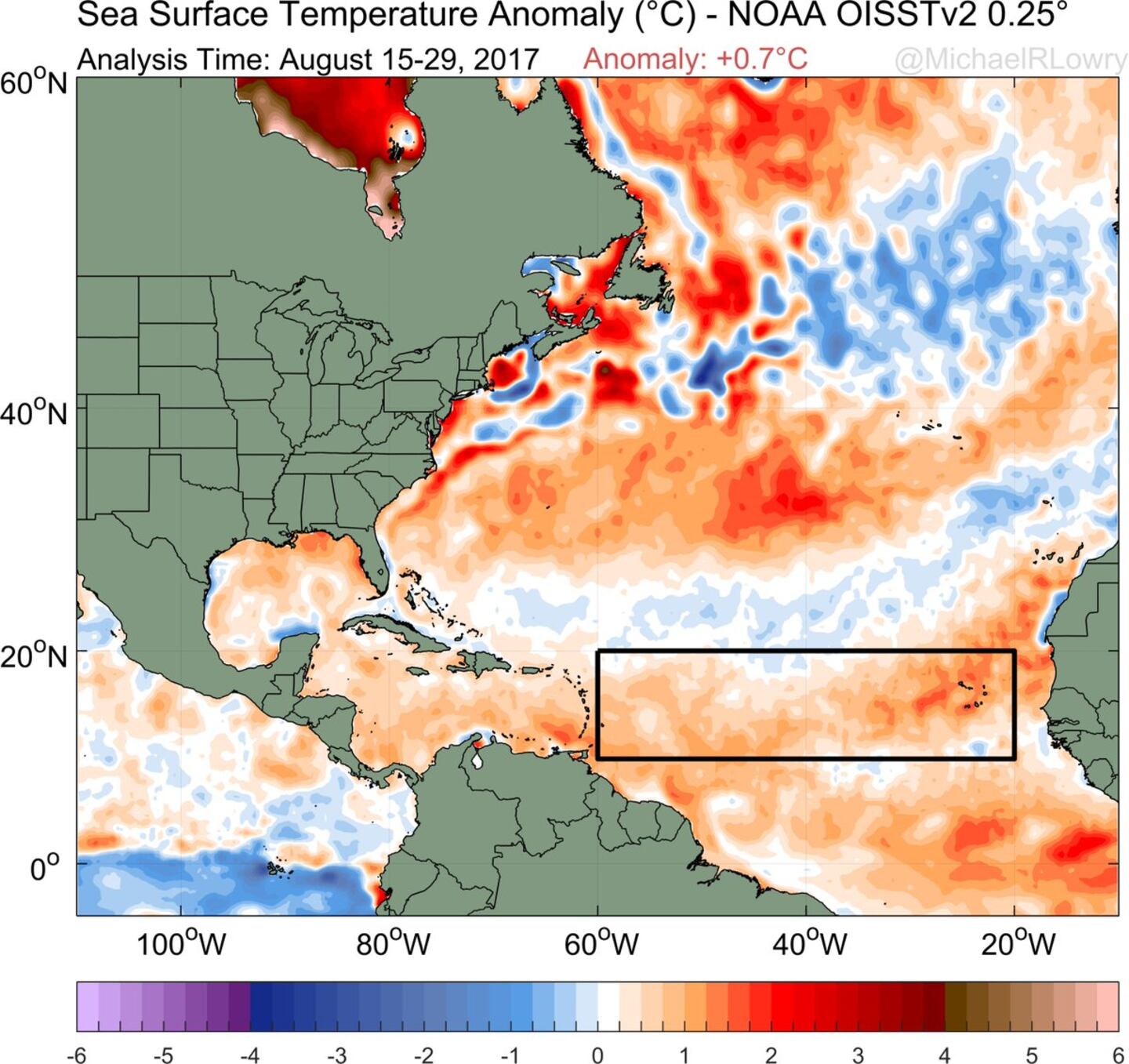
The main development region (MDR) shows above avg. temps. - in fact - only 2005 & 2010 were warmer. The deep warm ocean water can "energize" tropical cyclones:
SE U.S. surface map:


Surface analysis centered on the tropical Atlantic:

Surface analysis of the Gulf:

Caribbean:

The Eastern Pacific has an active storm too. "Lidia" is hitting the Baja of California & Western Mexico. Some of this tropical moisture may eventually make it into the SW U.S.
Harvey makes another landfall...... tropical storm "Irma" forms over E. Atlantic + eye on Western Gulf (again!).......
The "Buresh Bottom Line" is: stay tuned!... Always be prepared!..... City of Jacksonville Preparedness Guide... Georgia Hurricane Guide.
East Atlantic -- as we head into the peak of the Cabo (Cape) Verde season, waves are rolling west off Africa. One particularly active wave - 15 degrees N/30 degrees W - will likely soon be "Irma". The very early call on this one is a hurricane that recurves over the West Atlantic but still a lot of time for steering currents to change & models - as a whole - have trended west (but have also been all over the place!). There are some long range global forecast models that this cyclone well into the W. Atlantic by the middle of next week - close to the NE Caribbean Islands including Puerto Rico while other models show a more northward turn earlier. I can say this potential storm will stay away from the U.S. & any land areas through Labor Day. Any building/movement &/or strengthening of the Bermuda High - which has been quite strong for months - makes storm recurvature more difficult. There may also be a rather deep upper level trough that moves into the Eastern U.S. next week which could play a role in the eventual movement of what should be our next Atlantic tropical cyclone.
I am also keeping a watchful eye on the NW Gulf of Mexico (yet again!) as indications are that low pressure will try to develop over the Western Gulf next week. Whether or not this becomes a tropical system, the pattern could produce more heavy rain for parts of Texas - thinking next Tue. - Thu. or so.

Horrible & historic "Harvey" - see "Buresh Blog" for some pics & further perspective - roared ashore as a powerful Cat. 4 hurricane Fri. evening about 11pm EDT near Rockport about 30-35 miles NE of Corpus Christi. This track spared Corpus Christi from extreme damage but torrential rain & flooding have stolen the headlines since Fri. Harvey was the first "major" U.S. landfalling hurricane since Cat. 3 "Wilma" slammed South Florida in Oct., 2005 - that's longest such stretch on record.... & was the first U.S. Cat. 4 landfall since "Charley" in 2004 which hit the west coast of Florida (Punta Gorda). The 938mb pressure is the 6th lowest on record for a Texas landfalling hurricane (Klotzbach). It is my humble opinion that while the death toll may not end up as high as hurricane Katrina in 2005.... nor was the storm surge as severe, most other measurements (meteorologically, property damage) will exceed Katrina.
Harvey made a third landfall (there were technically two landfalls Fri. night along the Texas coast/intracoastal) near the La./Tx. border early Wed. as a weak - but WET - tropical storm. Beaumont & Port Arthur, Tx were the latest victims to the unrelenting rain with more than 2 feet of rain from Tue. into Wed. morning. The center will slowly move north then pick up speed & move more northeast while weakening through Fri. Heavy rain & isolated tornadoes will continue to accompany the system though total rainfall amounts will not be as great as the past several days due to a combination of weakening & a little faster movement.
"Harvey" will stay far to the west & northwest of Florida so no direct impacts on Jacksonville though trailing moisture & weak disturbances will enhance rainfall Fri. into Sat.
While the exact death toll is still not known.... It should be noted that the NHC & local NWS offices in Texas & Louisiana should be commended on excellent forecasts & warnings well in advance of "Harvey" including as the storm moved off the Yucatan Peninsula when the system looked so minor & meager. I believe this might be one of the best, most accurate forecasts in modern history regarding a big hurricane that hit the U.S. - especially considering the system was little more than a wave/weak low pressure system when moving off the Yucatan Peninsula .... offering us some hope when it comes to the ever perplexing tropical intensity forecast. A storm with this "personality" years ago would have killed scores. Having said that.... obviously the toll is severe & epic for what is statistcally a once in a lifetime storm.
Lake Charles, LA NWS Doppler radar loop:
Houston Doppler radar loop where the rain from Harvey is finally over:


4
Fascinating imagery(!) from CIMMS, University of Wisconsin, Madison - Microwave radar-simulated imagery... click here for full definition..... note the bright colors overnight Tue. which coincided with tremendous rainfall rates in the Beaumont/Port Arthur area as Harvey made another landfall....

6
Spaghetti plot for "Harvey":
7
The tropical disturbance that was near Fl. over the weekend failed to become fully tropical & is now a big ocean storm over the N. Atlantic:
Tropical cyclone formation probability over next 1 - 2 days:
Wind shear analysis (red is stronger shear):
Water vapor imagery:
Imagery below courtesy CIMMS shows African Saharan dust (orange & red)....
SE U.S. surface map:
Surface analysis centered on the tropical Atlantic:
Surface analysis of the Gulf:
Caribbean:


Cox Media Group


