
Sept. 13, 2018 — The "Buresh Bottom Line": Always be prepared!.....First Alert Hurricane Survival Guide... City of Jacksonville Preparedness Guide... Georgia Hurricane Guide.
STAY INFORMED: Get the (free) First Alert Weather app
Passed Jacksonville, FL latitude late Wed. hundreds of miles to the east... still 250+ miles NE of Jacksonville at/near landfall through Fri.:
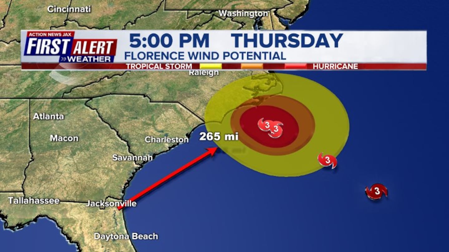
NEW "fork in the road"!: At or while approaching landfall Thu. night/Fri., the steering influences collapse & Florence will slow to a crawl. At this point, Florence will drift &/or move erratically possibly including a move south &/or southwest. As long as Florence makes landfall - or at least gets close enough to the coast to feel the effects (friction, dry air, shear) - the hurricane will weaken. But this set-up & possibility deserves close attention, especially for S. Carolina & Eastern Georgia. I am not expecting Florence to dip as far south as Jacksonville, FL but rather stays in or near the Carolina's through the weekend.
LOCAL - JACKSONVILLE & VICINITY - FLORENCE IMPACTS:
* Through Sunday: primary impacts look to be a breeze & very rough seas/surf & dangerous rip currents. All boaters stay in port! Surfers will be tempted by decent & "clean" waves but beware of dangerous rip currents.
* Virtually NO impacts inland.
* Stay up to date on the latest & potentially changeable forecasts.
* Despite the wide span of Florence's winds & rain, no rain bands will directly affect NE Fl./SE Ga.... & - in fact - skies will be relatively sunny late into the weekend. Strongest winds stay well offshore to the east & northeast of Jacksonville. If Florence drops south & southwest, additional impacts would be possible but not until Sunday/Monday & not likely significant.
Everyone up & down the east coast of the U.S. - particularly the Carolina's - needs to stay vigilant regarding the latest forecasts...
If you have - or will purchase - a generator, make sure you understand the "in's & outs" - click here.


"Florence" which became the 3rd hurricane, 1st "major" of the '18 Atlantic season Tue.... went Cat. 3 then briefly Cat. 4 last Wed. ... fell apart in the face of shear & dry air Thu.... continues moving into the Western Atlantic & made the expected comeback reaching Cat. 4 strength again Mon. The tropical cyclone made the important turn northwest reaching Jacksonville's latitude BUT hundreds (400+) of miles to the east - late Wed./Wed. night. There will continue to be fluctuations - both up & down - in intensity. Florence went through some serious structural alterations Wed. probably due to nearby dry air & some shear which has caused weakening. The eye was still open to the SE according to hurricane hunter aircraft as of late Wed. night. Florence is running out of time to significantly strengthen, so it looks like a probable Cat. 2, possibly low end Cat. 3 landfall Thu. night/early Fri.
Despite recent weakening, Florence still looks to be a big hit on the Carolina's: Major to severe impacts can be expected on the S. & especially N. Carolina coasts. Don't make the mistake of getting too caught up in individual run output of any particular model.... OR in what unreliable sources might be posting.... OR tracking just the center! Dangerous conditions will extend far from the eye of Florence. And do NOT underestimate the power of Florence even though the storm has weakened. Very heavy rain will cause widespread flooding, & the storm surge will likely be greater than what might usually be expected with a Cat. 2 storm.
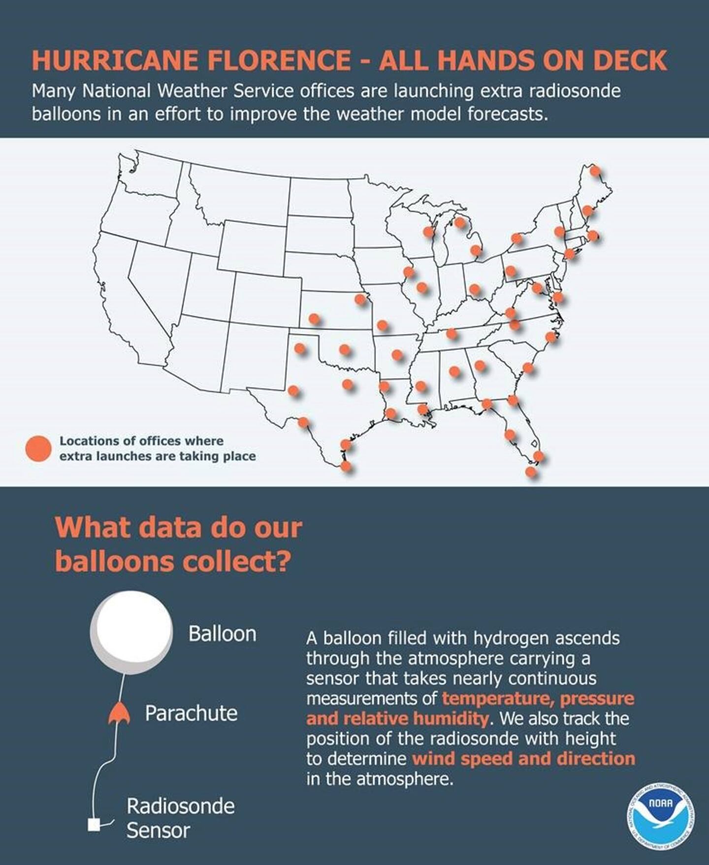
As for the forecast models, there has been a seemingly recent stabilization pointing to the Carolina's. This could be thanks to the aircraft analysis that has been recently ingested into the computer models. Virtually all reliable global models are pointing at or near the Carolina's - not far from or a little northeast of Myrtle Beach to Wilmington. The UKMET, European & GFS models - have come into decent agreement on a hurricane near the Gulf Stream moving into N. Carolina &/or Northeast S. Carolina but have been too high on intensity. For now... research aircraft is scheduled to continue gathering input for forecast models. That's in addition to special atmospheric soundings across the eastern half of the U.S. (4 balloon releases instead of the standard 2). This data will be in the model initialization hopefully leading to an even more accurate long term track & intensity forecast.
Having said that - & as mentioned at the top - we have an increasing spread in what will happen Fri. into the weekend once Florence approaches the coast &/or moves inland. There's better agreement now only some "dip" south/southwest then straightening back to the west before curving rather sharply north then northeast & accelerating early next week as Florence gets caught up in the westerlies. In any case... once inland, Florence will have lost its energy source - the warm ocean water & will rather quickly fill & weaken but still capable of dumping very heavy rain.
Once the steering currents collapse, Florence will flounder over or near the Carolina's pounding the beaches with wave action & dropping tremendous amounts of rain - most significant of these impacts will be north & northeast of the center.
So overall.... the critical points - "the forks in the road":
(1) when Florence was between Bermuda & the U.S. coast which kept Florence on a straight forward west then northwest course toward the Carolina's.
(2) Now we have a 2nd fork in the road - the weekend developments/movement. I continue to favor a scenario that takes Florence well northeast of Jacksonville in the short term hitting northeast of Myrtle Beach & near Wilmington, NC.. STAY UP TO DATE! As Florence slows upon nearing the coast, flooding problems & beach erosion - especially north of the eye could be tremendous.... & will also make pinpointing exact landfall + the intensity extra problematic.
So review hurricane plans, kits & do some work on & around the house before any severe weather moves in (cleaning storm drains, gutters, etc.). It looks like direct impacts on the U.S. will continue through Mon., the 17th or so in one form or another.
Bottom line: Don't panic but always be prepared.....

0
1

The map below is a mirror of the above spaghetti plots but shows an ensemble of all the model runs. DEFINITION OF ENSEMBLE MODELING: A set of forecasts that present the range of future weather possibilities. Multiple simulations are run, each with a slight variation of its initial conditions and with slightly perturbed weather models. These variations represent the inevitable uncertainty in the initial conditions and approximations in the models. They produce a range of possible weather conditions.


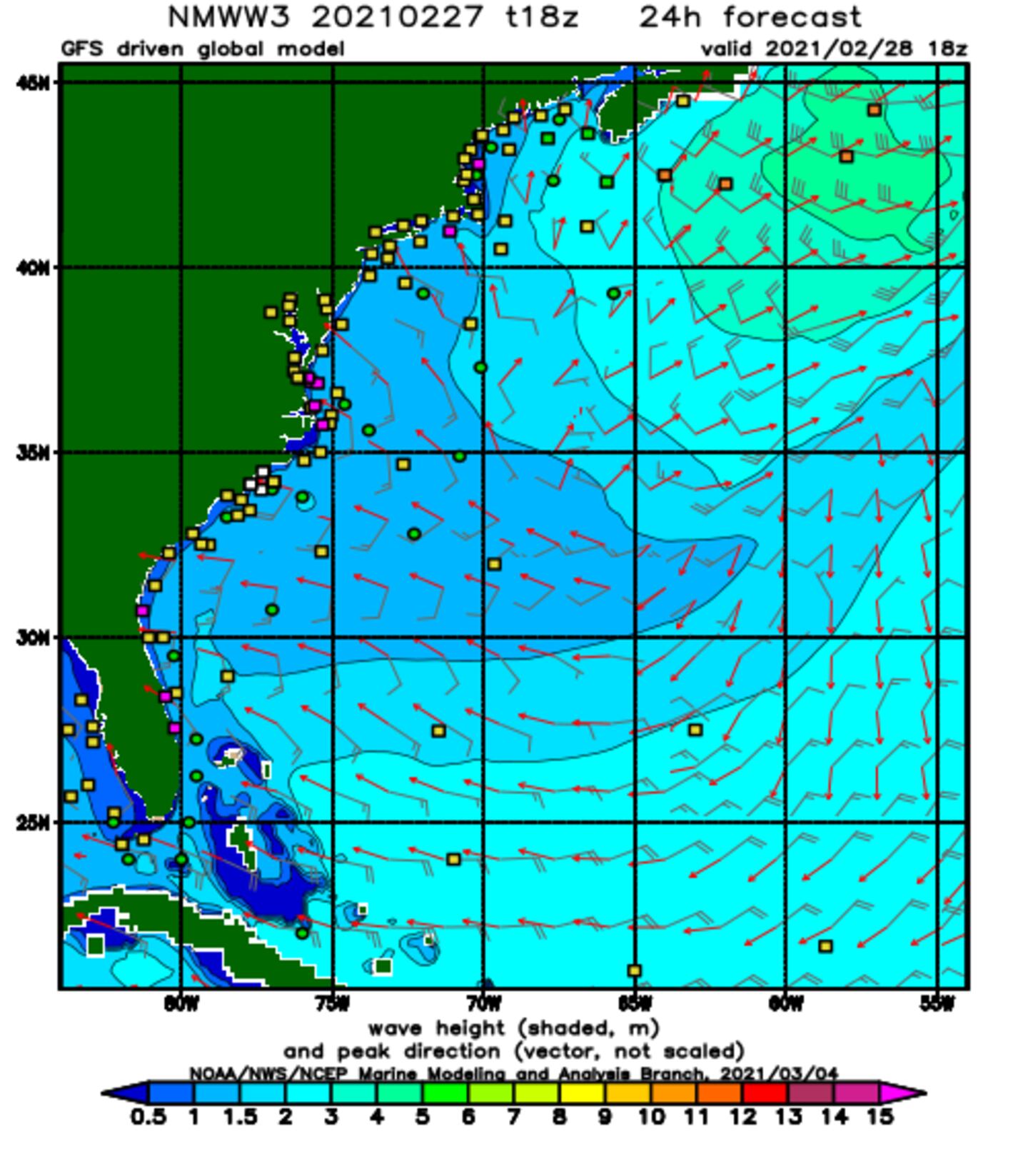
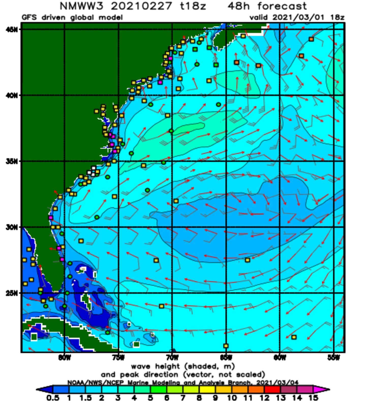
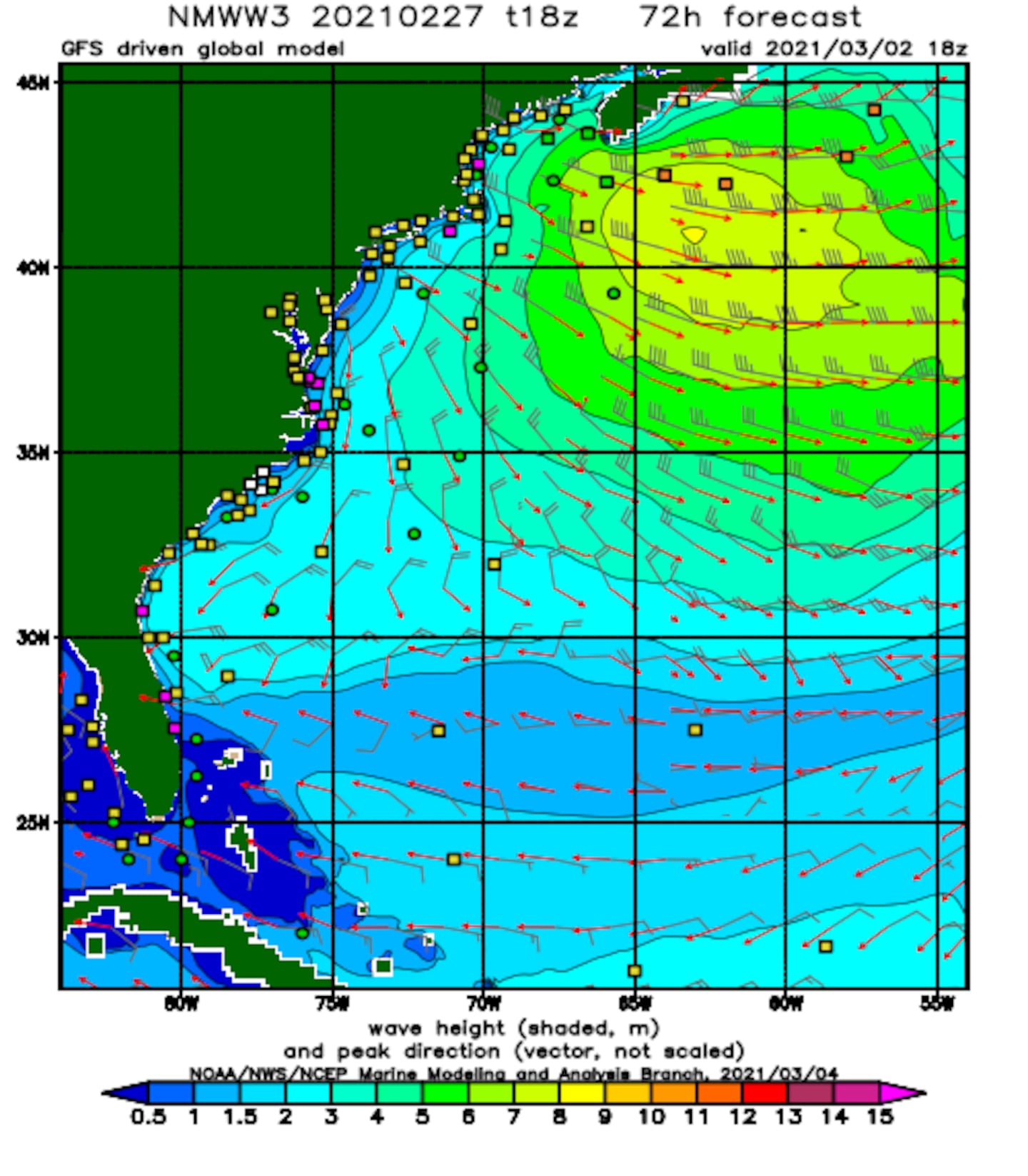
Wave height model (GFS) forecast... European model a little more south & west which - if verifies - wave heights would be higher for NE Fl./SE Ga. but still much more significant for the coastal Carolina's north to Chesapeake Bay:
Heavy rain by late week middle east coast. Rainfall over parts of N. Carolina & Virginia may exceed 1-2 feet!:

Wide view of the busy Atlantic Basin. This is the first time in 10 years - since 2008 (Klotzbach) - there have been 4 named storms in the Atlantic Basin. Joyce developed over the N. Atlantic Wed. Another wave is moving off Africa & will move westward. Forecast models are also showing possible long range development near & south of Bermuda & northeast of the Bahamas.

Isaac will move farther west over the Atlantic as high pressure tries to assert itself across parts of the Central/Northern Atlantic & underneath Florence. Shear looks to stay strong over the Caribbean in the long run which should cause Isaac - a small tropical cyclone - to weaken pretty quickly. The GFS & European models are very similar in this regard. Issac is moving through the islands of the Lesser Antilles but impacts will be minor - some heavy rain, gusty winds & rough seas/surf. IF Isaac can somehow survive its current hostile environment, somewhat more favorable conditions will be over the W. Caribbean & Gulf of Mexico next week.
Helene, on the other hand, looks like a full recurve over the Central/ E. Atlantic. Helene might interact with Joyce over the N. Atlantic. Both, however, stay far to the east over the open Atlantic.
I'm also keeping an eye on the NW Caribbean &/or Gulf of Mexico for possible tropical development. There has been a persistent area of t'storms over the W. Caribbean - something to watch. Movement will be west/northwest, so this will be a Western Gulf "thing" & not a problem for Florida. Gulf disturbance spaghetti plots:

Isaac, Helene & Joyce over the E. Atlantic:
Isaac:


Helene:

Joyce:


Mid & upper level wind shear (enemy of tropical cyclones) analysis (CIMMS). The red lines indicate strong shear. Note weaker shear in the path of Florence over the W. Atlantic while there's much stronger shear over the Caribbean......

The Atlantic Basin....

Caribbean:
Gulf of Mexico:
6
Water vapor imagery (dark blue indicates dry air) - notice the dry air right up against Florence:
7
Deep oceanic heat content is seasonably high over the Caribbean, Gulf of Mexico & SW Atlantic as one would expect now that we're near the peak of the hurricane season....

Sea surface temp. anomalies show a general recent warming over a good portion of the Atlantic Basin including rather dramatic warming east of the Caribbean & near the NE coast of S. America ....

SE U.S. surface map:

Surface analysis centered on the tropical Atlantic:

Surface analysis of the Gulf:

Caribbean:

The Central Pacific: A weak Olivia has moved through Hawaii & will be followed by improving weather conditions....
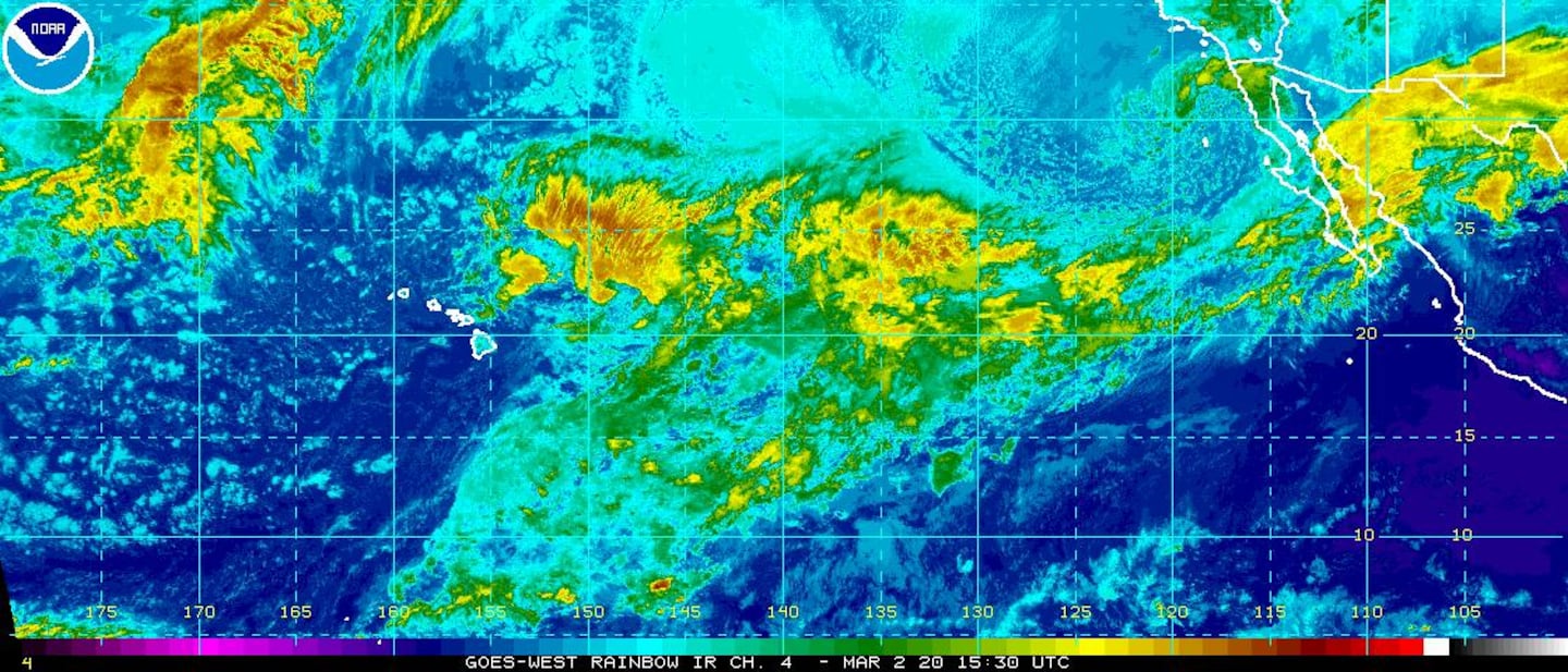
Olivia:

Cox Media Group


