JACKSONVILLE, Fla. — The Action News Jax First Alert Weather Team is tracking a warm and muggy evening, with early chances for showers.
Notes from the meteorologist:
- A few showers and storms are possible through the 5-6 pm timeframe in NE Florida mainly north of I-10.
- Showers and storms in SE Georgia could bring gusty winds through 6 pm.
- Warm and muggy this evening with temperatures in the 80s.
- We drop down to the lower to mid 70s tomorrow morning.
- Showers and storms will redevelop by midday to the west of Jacksonville and spread east through 2-4 pm Tuesday.
- Storms that do form will be capable of brief torrential rain, strong gusty winds, and frequent lightning.
- Wednesday and Thursday look to feature the most storms across our area with an active sea breeze.
TROPICS:
- No areas of concern.
INTERACTIVE RADAR: Keep track of the rain as it moves through your neighborhood
WATCH THE FORECAST | DOWNLOAD THE APPS
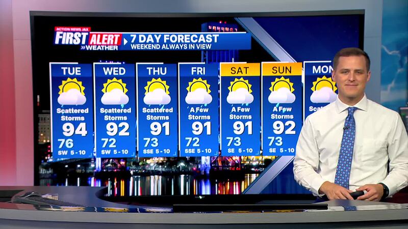
First Alert 7-Day Forecast:
- TONIGHT: Partly cloudy and humid with an isolated storm early. LOW: 76
- TOMORROW: Partly cloudy with widely scattered afternoon storms. High: 94
- WEDNESDAY: Partly cloudy with scattered storms. 72/92
- THURSDAY: Partly cloudy with scattered storms. 73/91
- FRIDAY: Partly cloudy with a few storms. 72/91
- SATURDAY: Partly cloudy with a few storms. 73/91
- SUNDAY: Partly cloudy with a few storms. 73/92
- MONDAY: Partly cloudy with scattered afternoon storms. 74/93
Follow Action News Jax Meteorologists on Twitter for updates:
Mike Buresh | Garrett Bedenbaugh | Corey Simma | Trevor Gibbs
SHARE WITH US: Send us photos of the weather you’re seeing in your area ⬇️


