JACKSONVILLE, Fla. — This morning we are tracking temperatures in the 50s in most neighborhoods away from the coast.
- Temperatures will rise into the lower to mid 80s well inland and 70s along the coast.
- Humidity will remain low today.
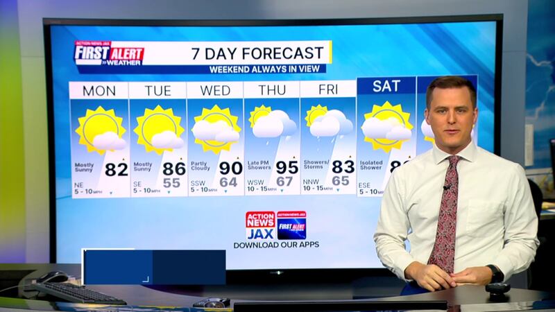
- This week will be warm with highs at 90+ by Wednesday and especially Thursday.
- Thursday: 95 (Record: 94 - 1977)
- Another front approaches late Thursday with some showers for the end of the week, but it doesn’t appear to be a lot of rain.
- Showers and a few storms linger into Friday.
TODAY: Mostly sunny and nice. HIGH: 82
TONIGHT: Mostly clear and cool. LOW: 55
TUESDAY: Mostly sunny and warm. 55/86
WEDNESDAY: Partly cloudy and hot. 64/90
THURSDAY: Partly cloudy and breezy. Hot and humid with a few showers late. 67/95 (Record: 94 - 1977)
FRIDAY: Mostly cloudy with a few showers/storms. 65/83
SATURDAY: Partly cloudy and warm with an isolated shower. 62/83
SUNDAY: Partly sunny with an isolated afternoon shower. 65/85
WATCH THE FORECAST | DOWNLOAD THE APPS
Follow Action News Jax Meteorologists on Twitter for updates:
Mike Buresh | Garrett Bedenbaugh | Corey Simma | Trevor Gibbs
ALLERGY TRACKER: See what the pollen counts look like in our area
LISTEN: Mike Buresh ‘All the Weather, All the Time’ Podcast
INTERACTIVE RADAR: Keep track of the rain as it moves through your neighborhood
SHARE WITH US: Send us photos of the weather you’re seeing in your area ⬇️


