JACKSONVILLE, Fla. — Notes from the First Alert Weather team:
- Sunday morning is mild with temperatures in the 60s under partly cloudy skies.
- Temperatures will be very warm on Sunday, rising to the upper 80s/near 90.
- There will be abundant dry time on Sunday, but some mid-late afternoon rain is expected.
- Coverage of rain will be greatest east of Highway 301 to the beaches, where a few showers/embedded thunderstorms or two are possible.
- A cold front will pass through the area late Sunday night and slow down through Monday.
- This front will keep clouds, cooler temperatures, gusty onshore winds, and a few showers over our area at times Monday and Tuesday.
- Stronger onshore winds continue for Wednesday, keeping rough seas/surf up and down the coast for much of next week.
- Beneficial rain is expected for much of northeast Florida, especially toward the coast.
- Where drought is the worst (toward I-75), predicted rainfall amounts are the least (less than 0.25″).
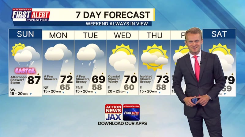
First Alert Weather 7-day forecast:
SUNDAY: Partly cloudy and very warm. A few afternoon showers/storms. HIGH: 87
SUNDAY NIGHT: Partly cloudy and mild. LOW: 65
MONDAY: Mostly cloudy and cooler with a few showers. 65/72
TUESDAY: Mostly cloudy and breezy with a few showers. 58/69
WEDNESDAY: Partly to mostly cloudy and windy with a brief coastal shower. 60/70
THURSDAY: Partly cloudy and breezy with a brief shower. 58/73
FRIDAY: Partly cloudy 59/77
SATURDAY: Mostly cloudy. 63/79
WATCH THE FORECAST | DOWNLOAD THE APPS
Follow Action News Jax Meteorologists on Twitter for updates:
Mike Buresh | Garrett Bedenbaugh | Corey Simma | Trevor Gibbs
ALLERGY TRACKER: See what the pollen counts look like in our area
LISTEN: Mike Buresh ‘All the Weather, All the Time’ Podcast
INTERACTIVE RADAR: Keep track of the rain as it moves through your neighborhood
SHARE WITH US: Send us photos of the weather you’re seeing in your area ⬇️


