JACKSONVILLE, Fla. — This morning is chilly with temperatures in the 30s inland and lower 40s along the coast.
- Some areas of frost, especially well inland.
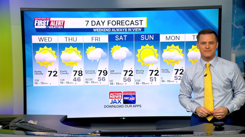
- Highs today will rise into the lower 70s with a few clouds.
- Winds will be out of the southwest at 5-15 mph.
- Any wildfire smoke will blow northeast today.
- Highs will reach the upper 70s by Thursday.
- A few showers arrive Friday during the evening for Jacksonville and linger into early Saturday.
- The daytime Saturday forecast has trended drier.
TODAY: AM inland frost. Partly sunny and mild HIGH: 72
TONIGHT: Partly cloudy. LOW: 46
THURSDAY: Partly sunny. 46/78
FRIDAY: Partly cloudy. A few evening showers. 56/79
SATURDAY: Mostly cloudy. A few showers early. 56/72
SUNDAY: Partly cloudy. 51/72
MONDAY: Partly cloudy. 52/72
TUESDAY: Partly sunny. 57/78
WATCH THE FORECAST | DOWNLOAD THE APPS
Follow Action News Jax Meteorologists on Twitter for updates:
Mike Buresh | Garrett Bedenbaugh | Corey Simma | Trevor Gibbs
ALLERGY TRACKER: See what the pollen counts look like in our area
LISTEN: Mike Buresh ‘All the Weather, All the Time’ Podcast
INTERACTIVE RADAR: Keep track of the rain as it moves through your neighborhood
SHARE WITH US: Send us photos of the weather you’re seeing in your area ⬇️


