DOWNLOAD: Get the free First Alert Weather app for Tropics updates
DOWNLOAD: Get the free Action News Jax app for news alerts
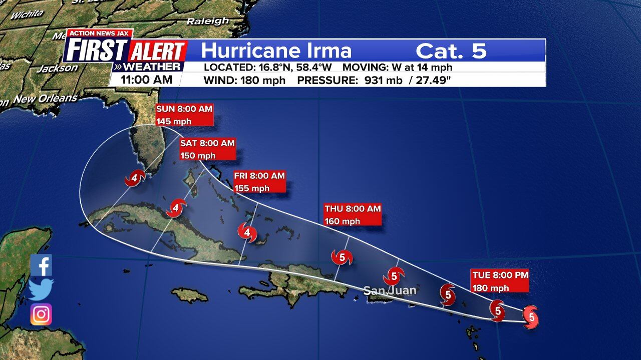
Hurricane Irma is now a Category 5, continuing to strengthen with wind now at 180 mph as it heads west through the Atlantic at 14 mph.
BREAKING: Irma is now a category 5 storm. Wind at 175 mph. #FirstAlertWx pic.twitter.com/YT3BMNRaW4
— Erin Clanahan (@ErinClanahanCBM) September 5, 2017
Wednesday the storm is expected to be near Puerto Rico and by Friday it will be near Cuba.
The storm is then expected to make a quick turn to the north early Sunday morning, but it is still unknown at this time what that track will look like.
#Irma timline. #FirstAlertWx pic.twitter.com/VyXHLePQpq
— Erin Clanahan (@ErinClanahanCBM) September 5, 2017
#Irma will be traveling through very warm water in the Caribbean over the next couple of days. pic.twitter.com/96T9cQbttd
— Erin Clanahan (@ErinClanahanCBM) September 5, 2017
Chief Meteorologist Mike Buresh said the last Category 5 over the Atlantic Basin was Hurricane Matthew last year when it hit Haiti as a Catgeory 4 storm, then headed east to Florida and along our local coastline as a Category 3 storm.
The government of the Dominican Republic has issued a Hurricane Watch from Cabo Engano to the northern border with Haiti and a Tropical Storm watch from south of Cabo Engao to Isla Saona.
Emergency officials are warning that Irma could dump up to 10 inches (25 centimeters) of rain, unleash landslides and dangerous flash floods and generate waves of up to 23 feet (7 meters) as the storm draws closer.
One should always be prepared throughout the hurricane season with your hurricane supply kit.
Read more with Talking Tropics with Mike Buresh.
BREAKING: Irma is now a Category 5 storm with winds of 175 mph >> http://bit.ly/2wBWm7b
Posted by Action News Jax on Tuesday, September 5, 2017
Cox Media Group


