
Jacksonville, FL — “Talking the Tropics With Mike” updated every day throughout the hurricane season.
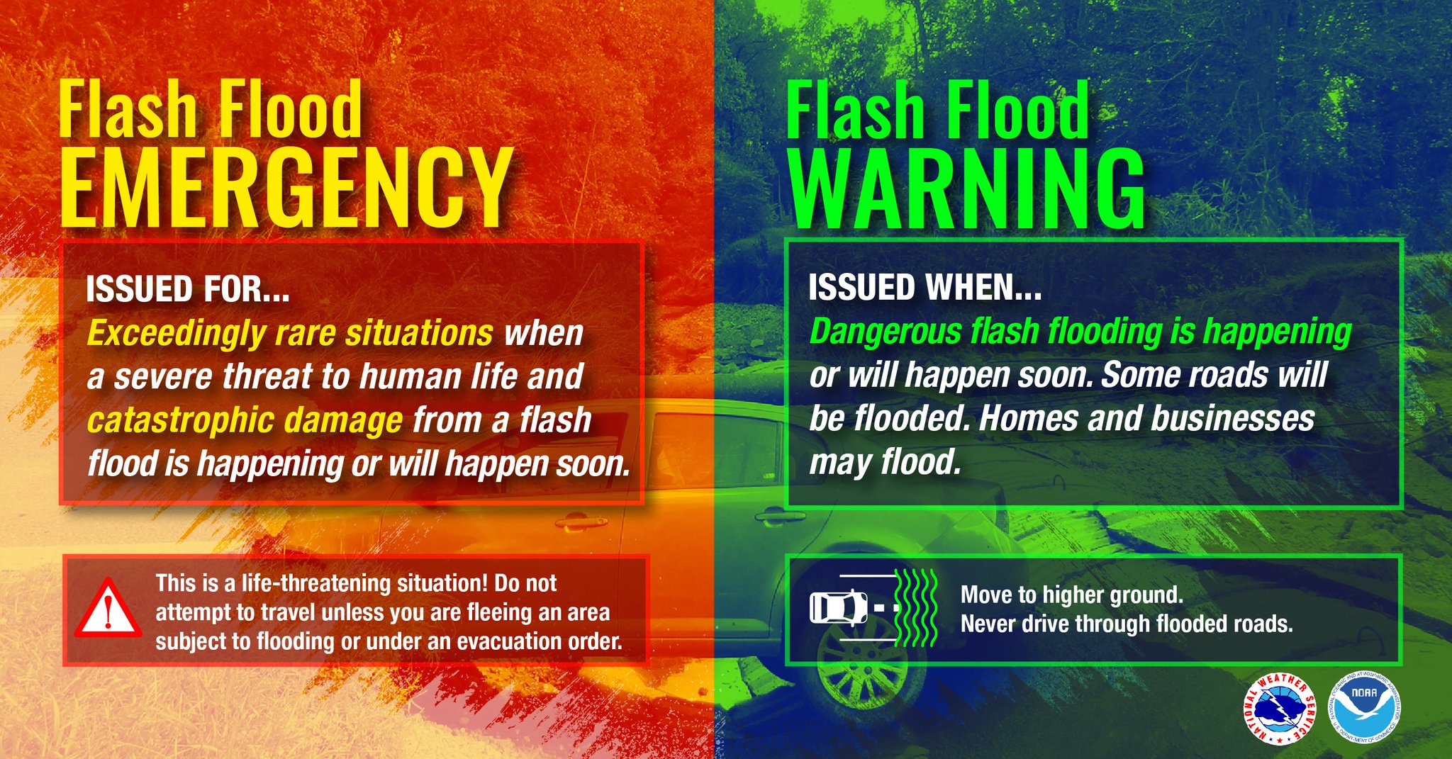
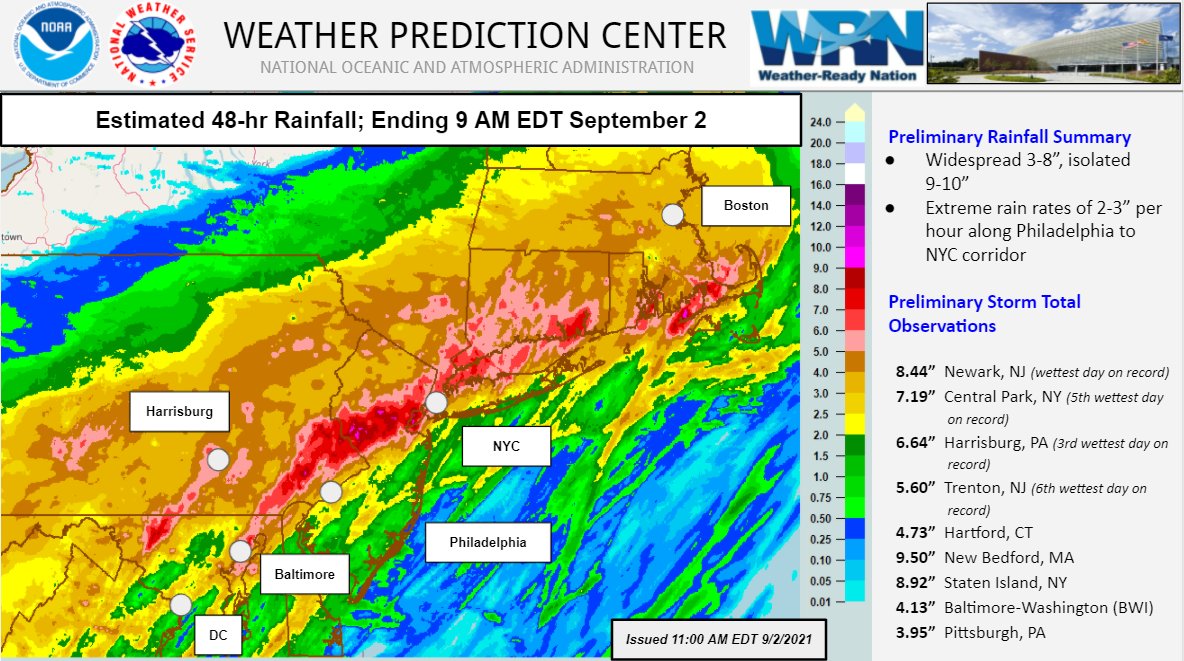
So “Ida” is now history & will go down in the history books no doubt. Yet another ‘I’ name to be retired (Iris-2001; Isidore-2002; Isabel-2003; Ivan-2004; Ike-2008; Igor-2010; Irene-2011; Ingrid-2013; Irma-2017; Iota-2020). The Cat. 4 landfall in Louisiana resulted in one of the - if not the - greatest loss of the modern electrical grid in the U.S. following a hurricane (yes - greater than Andrew, Katriana, Harvey, Laura & Michael just to name a few). But landfall didn’t end the Ida saga. The system lost a lot of its pure tropical power once over land but still produced tornadoes & flash flooding all along its track inland through the deep south, Tennessee Valley & parts of the Ohio Valley. The storm’s final mighty blow was delivered on the mid Atlantic & Northeast as Ida’s remnants encountered a stalled front & became absorbed by an upper level trough helping to tighten Ida’s circulation despite being post-tropical (in technical meteorology lingo: strenthened due to baroclinicity). The result was an afternoon & evening (Wed., 09/01) of intense tornadoes & horrific flash flooding for Washington D.C., Baltimore, Philadelphia, New York City & Boston. The hour by hour rainfall was historic for New York City itself *but* realize that storms like Ida have occurred in the past & will occur again. Landfalling hurricanes are notorious for producing huge amounts of rain as well as tornadoes sometimes well inland & sometime long after landfall. And much was made about the “First ever flash flood warning emergency for New York City” issued by the N.W.S. Understand the product has only been existence for about 10 years. Issuance of such a warning for any one area is not going to be a common occurrence. For Jacksonville... a flash flood emergency has been issued in 2016 during hurricane Matthew & in 2017 during Irma. The ultimate lesson should be mitigation otherwise we are condemned to repeat history. South Florida, for instance, learned the hard way after “Andrew” in 1992 but now building codes in S. Florida are some of the strictest in the nation & have proven time & time again to be very effective despite the higher costs on the “front end”.
Rainfall from Ida’s remnants across the Northeast:
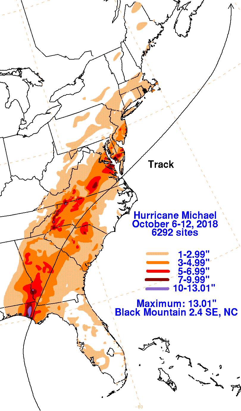
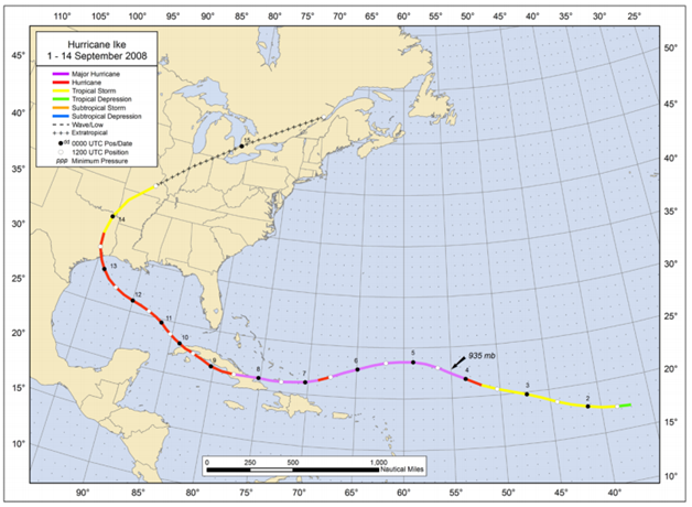
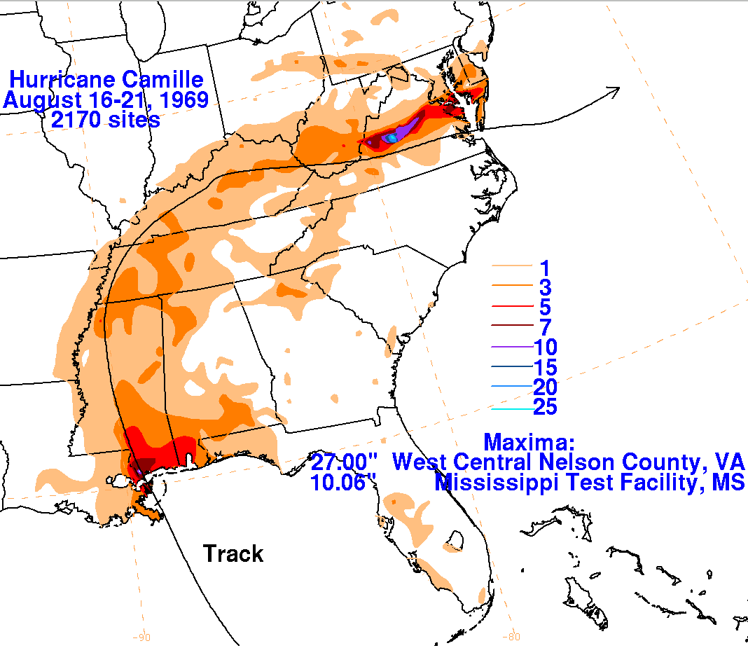
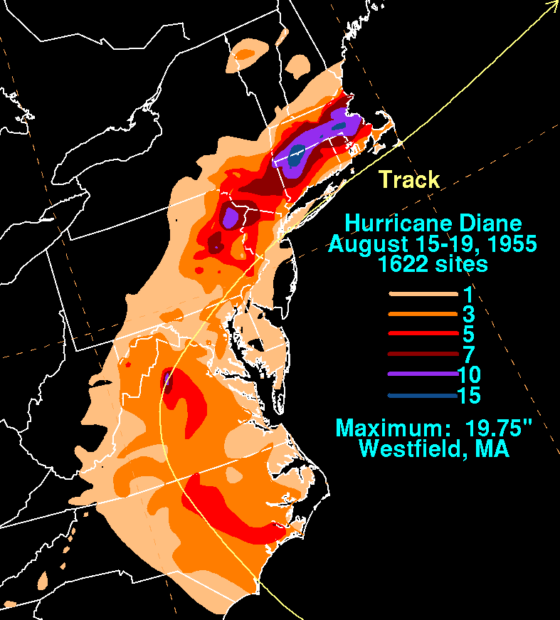
Other U.S. hurrricanes that have caused severe weather & damage long after landfall include Michael (2018), Ike (2008), Ivan (2004). Floyd (1999), Eloise (1975), Camille (1969), Diane (1955) to name just a few.
Michael, 2018:
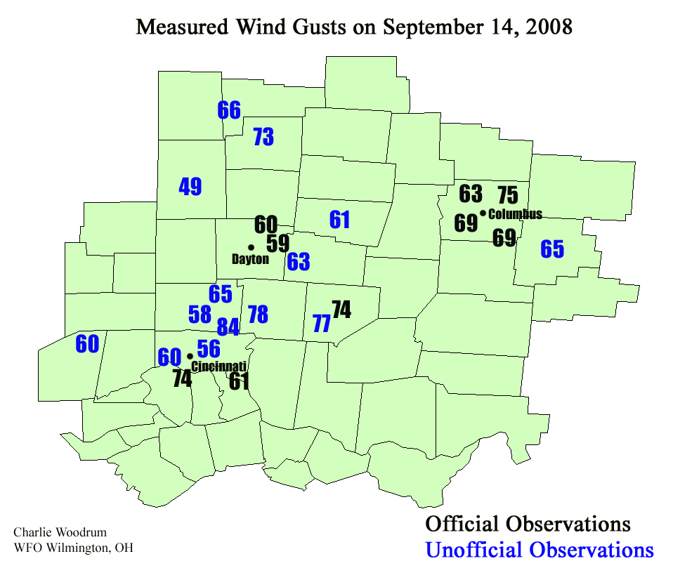
Ike in 2008 produced damaging winds as far inland as the Ohio Valley!
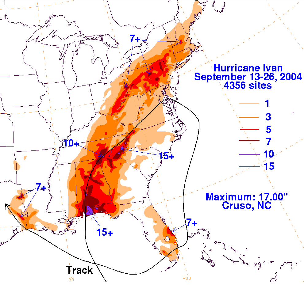
Ivan, 2004:
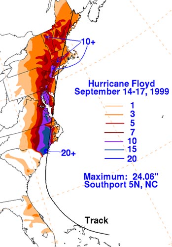
Floyd, 1999:
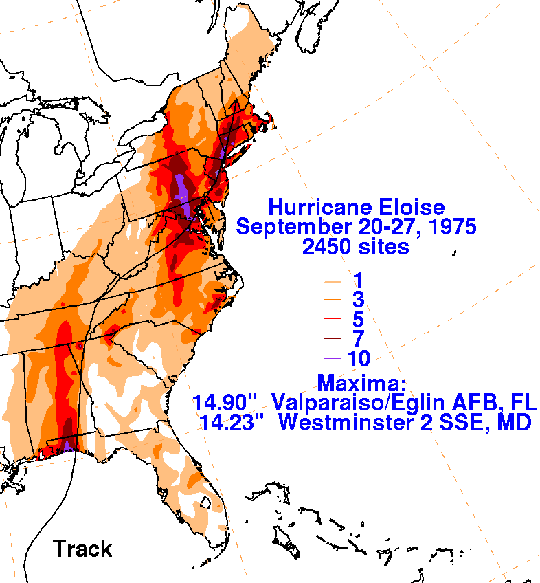
Eloise, 1975:
Camille, 1969:
Diane, 1955:
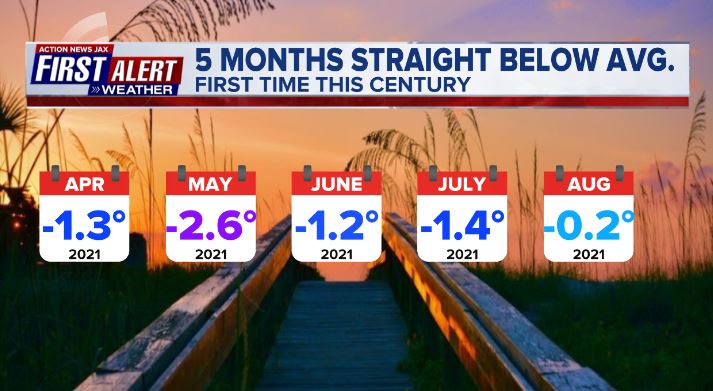
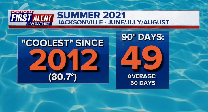
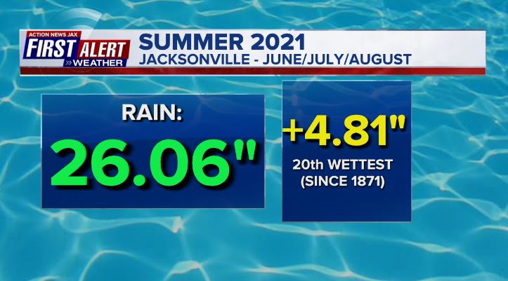
Some interesting & perhaps unlikely stats for Jacksonville - Aug. was the 5th straight month with below avg. temps. which hasn’t happened this century! And “meteorological summer” - June/July/Aug. - was the coolest since 2012 (avg. at 80.7 degrees is 1.0 degree below avg.) but also the 20th wettest on record.
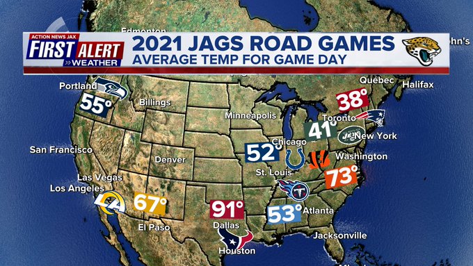
The NFL season is underway! You can watch every Jaguars game on CBS47 or Fox30. The Jags begin on the road in Houston where it’s likely the roof will be closed to keep it cooler. The map below shows all of the Jag’s road games & the avg. temp. for each city on game day:
The summer’s arctic sea ice melt is just about at its maximum. The trend of losing more ice during the summer vs. gaining ice in the winter continues though there has been some slight improvement (ice increase) the last 2 summers.
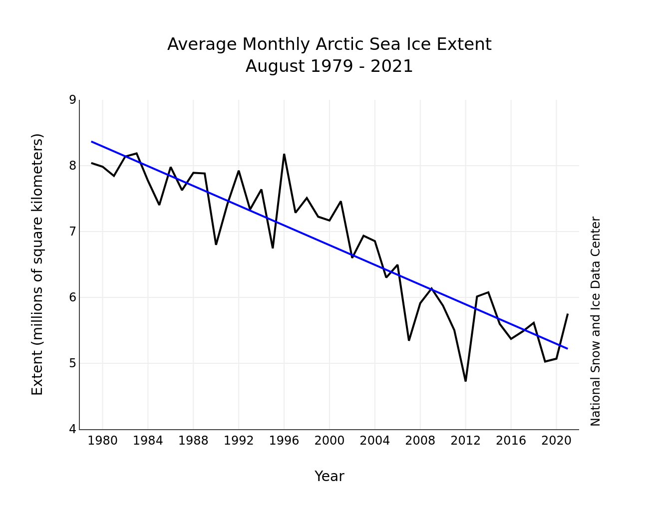
National Snow & Ice Data Center - well below the 30-year avg.:

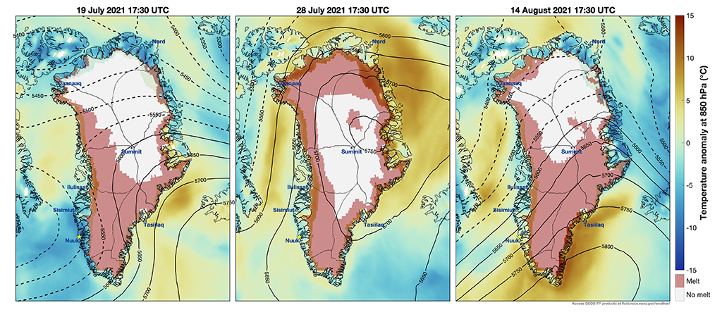
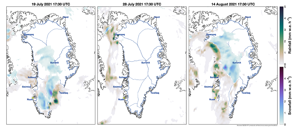
But what stands out is this summer’s Greenland melt. The full story from NASA * here *... an excerpt:
“The summer of 2021 is remarkable for a series of late-summer melt events that have covered large areas of the Greenland Ice Sheet, even extending to its highest point at Summit Station. These events have been captured in the GMAO Forward Processing (FP) analyses, and in routine numerical weather predictions produced from the GEOS forecast model. Shown in Animations 1-3 is the evolution of three Greenland melt events that occurred on 19-July, 28-July, and 14-August. At their peaks, these events produced simultaneous melt over 49, 63, and 59 percent of the total ice sheet area, respectively – an area ranging from 840,000 to 1.1 million square kilometers.
Melt events such as these occur through variations in the large-scale atmospheric circulation – specifically through an intensification of the prevailing anticyclonic circulation over the ice sheet. The typical mechanism is a blocking high pressure ridge that forms over the mid-latitudes of the North Atlantic Ocean. These are slow-moving features that block the zonal flow, are characterized by a capital omega-shape in the pressure field and are associated with midlatitude heatwaves.”
One of the most significant “heat waves” coincided with “rare” rainfall all the way to Summit Station. As noted by NASA:
“A notable feature of the 14-August event is presence of widespread rainfall on the high interior plateau (Animation 3), and there is a considerable rain shield extending over the western side of the ice sheet. Rain is not uncommon on the ice sheet, but almost exclusively occurs at the lower elevations of the ice sheet periphery. Rainfall extending to Summit Station is a very rare occurrence; rainfall further enhances surface melt through the introduction of liquid water onto the snowpack.”
Temps. & precip. (rain & snow) for the 3 major warm spells of July 19, July 28 & Aug. 14:
September night skies (Sky and Telescope):
Sept. 9 (dusk): The Moon, three days past new, is 3½° from Venus, while Spica blazes to the pair’s lower right. Look farther to the lower right to try to glimpse Mercury in bright twilight (challenging).
Sept. 12 (dusk): The waxing crescent Moon and Antares, the Scorpion’s heart, are 3° above the southwestern horizon.
Sept. 15 (evening): Look toward the south-southeast to see the Moon, Saturn, and Jupiter form a graceful line.
Sept. 15 (evening): The International Space Station begins a series of evening appearances that lasts through mid-October. Visit heavens-above.com for local predictions.
Sept. 16 (evening): The Moon approaches Saturn and sits a bit more than 4° lower right of the Ringed Planet.
Sept. 17 (evening): It’s Jupiter’s turn for a lunar visit — a fatter gibbous Moon hangs 5½° to the planet’s lower right.
Sept. 21: Equinox occurs at 3:21 p.m. EDT. Sun rises due east and sets due west no matter where you’re at.
Sept. 26 (dawn): Look high above the southwestern horizon to spot the Moon between Aldebaran and the Pleiades.
Oct. 3 (dawn): The waning crescent Moon and Regulus rise in tandem in the east a bit more than 4° apart.
Oct. 9 (dusk): Low in the southwest, the waxing lunar sliver and brilliant Venus are some 2½° apart in the Scorpion’s head, while Antares smolders 6° to their left.
Moon Phases
New Moon – September 6, 8:52 p.m. EDT
First Quarter – September 13, 4:39 p.m. EDT
Full Moon – September 20, 7:55 p.m. EDT
(Full Harvest Moon)
Last Quarter – September 28, 9:57 p.m. EDT
And - lastly - a bit of reflection on 9-11, twenty years later. First of all, it’s difficult for me to fathom it’s been two decades. One of my children was little more than 6 months old, our second not even born yet. I was leaving for work in Cincinnati, Oh. when the first tower in NYC was hit, & I was listening on the radio while on the road when the 2nd tower was hit. Shortly after I arrived at work, the Pentagon was targeted then a little later the jet crash in an open field in Pennsylvania. The shock of the day is not easy to convey. The Nation became galvanized (hard to believe these days) & the resolve of the country was remarkably strong. Though an unmitigated tragedy, the 9-11 events & how it brought America together was undeniable & memorable. My wife & I went to NYC just 4 months later in January. First Responders were still digging out at Ground Zero - human remains & building debris. Each time, a crew came off their shift & out of the “hole” as it was called, on-lookers would applaud from a platform that was built to allow people to witness the devastation & cleanup from a safe distance. There were still pictures of missing loved ones on a fence for many blocks as well as makeshift memorials. We felt we needed to see history to better understand it, to appreciate the sacrifices of so many. That trip left an indelible impression on us. We returned about 15 years later because we felt our children needed to understand & to remember this history. A visit to the 9/11 Memorial & Museum is a must. A few pics from our trip are below. We must never forget.


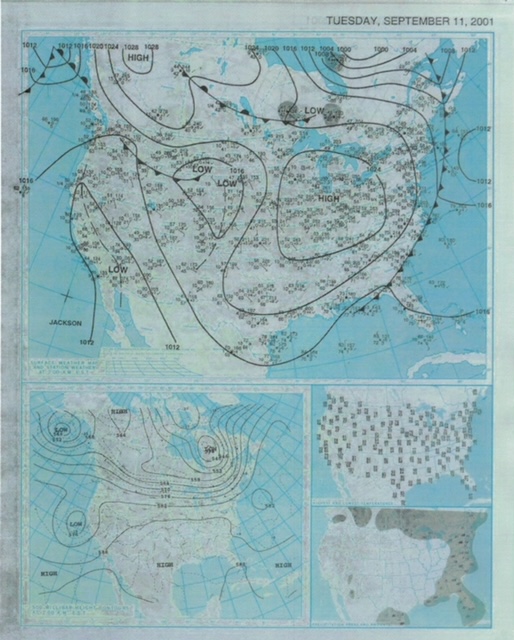
Oddly similar weather map to this year: hurricane Erin to the east over the NW Atlantic (Larry northwest of this position this year).... developing tropical storm “Gabrielle” (not yet on surface map) over the Gulf which hit Fl. 3 days later (tropical disturbance now over the Yucatan)....
©2021 Cox Media Group


