
JACKSONVILLE, Fla. — To become a part of the First Alert Neighborhood weather station network powered by Tempest - scan below &/or click * here *:

And just like that it’s the first month of the new year - 2026!:

Night skies (Sky & Telescope):
Jan. 9–10 (all night): Jupiter reaches opposition (appearing opposite the Sun and its brightest) in Gemini near Pollux.
Jan. 11 (morning): The last-quarter Moon hangs some 5° below Spic in Virgo.
Jan. 14 (dawn): The waning crescent Moon is 3½° upper right of Antares, in Scorpius.
Jan. 22 (dusk): The waxing crescent Moon is 6° to the lower right of Saturn. They draw closer as they sink in the west.
Jan. 27 (dusk): The Moon is just to the left of the star cluster in Taurus.
Jan. 30 (dusk): The waxing gibbous Moon forms a triangle with Jupiter and Pollux.
Jan. 31 (dawn): The almost-full Moon is accompanied by Pollux (4° behind it) and Jupiter (5° to its lower right).
Feb. 2 (evening): The Moon, just one day past full, rises in tandem with Regulus. Later the Moon occults (covers) the star for most of the U.S. and Canada.
Feb. 6 (evening): The waning gibbous Moon and Virgo’s brightest star Spica are about 1½° apart.
Moon Phases
Full Moon January 3 6:03 a.m. EST (Full Wolf Moon)
Last Quarter January 10 11:48 a.m. EST
New Moon January 18 3:52 p.m. EST
First Quarter January 26 12:47 a.m. EST
So we are a quarter of the way through the 21st Century! A few local weather highlights since 2000:
2003
Jan. 24 - 19 degrees - a record low for the date & the coldest morning of the century so far.
2004
Aug. 12 - Tropical storm “Bonnie” makes landfall in the Fl. Panhandle spawning a F-2 tornado in Jacksonville. Florida Times-Union photo:

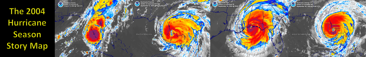
Aug. 13 - Cat. 4 hurricane “Charley” landfall at Port Charlotte exits at Daytona Beach - no impacts to Jacksonville but some wind & rain for Southern St. Johns & Putnam Co.
Sept. 5 - Cat. 2 hurricane Frances landfall at Stuart, Fl. - heavy rain, strong winds & power outages for Jax/NE Florida
Sept. 16 - Cat. 3 hurricane “Ivan” landfall near Gulf Shores, Alabama with serious damage in the Western Fl. Panhandle
Sept. 25 - Cat. 3 hurricane “Frances” landfall - Stuart, Fl. (again!) - another round of strong winds & heavy rain for Jax/NE Fl.
Oct. 5 - power fully restored across Fl. after the Sept. hurricane onslaught.
2005
Feb. 6 - Super Bowl 39 in Jacksonville! - Afternoon high of 65 degrees (Patriots beat the Eagles 24-21).
Aug. 25 - Cat. 1 Katrina landfall between Miami & Ft. Lauderdale (followed by catastrophic Cat. 3 Gulf landfall on Aug. 29)
Oct. 5 - Tropical storm “Tammy” landfall at Mayport - heavy rain Eastern Duval
Oct. 24 - Cat. 3 “Wilma” landfall on the southwest coast of Florida - heavy rain to Jacksonville
2006
Dec. 25 - Christmas day severe storms including F-2 tornado in Lake City.
2007
Feb. 2 - Florida overnight tornado outbreak from The Villages east to New Smyrna Beach - 21 deaths.
April 8 - 31 degrees - latest Jacksonville freeze on record.
April 15 - Baker Co., Fl. EF-2 tornado.
April 16 - Ware Co., Ga. wildfire ignites (tree branch of power line)
June 2 - Tropical storm “Barry” landfall north of Tampa brings heavy rain to the local area helping to extinguish Ware Co. wildfire
July 1 - Arlington lightning death
July 14 - 6 lightning injuries at Little Talbot Island
Oct. 1 - 7 - 18.4″ of rain in Duval Co. - widespread flooding
2008
March 7 - Lake City EF-2 tornado kills 2
June 1 - large hail on Jacksonville Southside causes considerably property damage near & south of the Town Center
Aug. 20-22 - Tropical storm Fay slowly moves east then west across Florida with 6-12″+ rain across NE Fl. & parts of SE Ga.


August was wettest Aug. on record with 16.83″ at JIA
Winter of 2008-’09 - 28 freezes - most since 30 in 2000-’01
2009
May 18-21 - Local nor’easter with widespread flooding across NE Fl. with 5-15″ of rain
June 26 - Large waterspout moves north along the St. Johns River from the Buckman Bridge to downtown Jax. The Florida Times-Union, Rick Wilson photo:

Dec. 15 - Tie all-time Dec. record high of 84 degrees
2010
Jan. 1-10 - coldest first 10 days of the year in Jax on record
Feb. 12 - Light snow in Ware Co., Ga.
March 31 - 80 degree high at JIA is the latest first 80-degree day of the year since 1948
June 15 - 102 degrees - tie record high in 1981 - hottest day of the 21st Century
July 30 - 102 degrees - daily record high (100/1941)
Aug. 26 - 50th straight day 90+ beats the old record of 44 straight days in 1992
October - no rain at JIA - first month ever with no measurable rain in Jacksonville (since 1871 & happens again in Nov., 2025)
December - Coldest Dec. on record - minus 8.9 degrees... 2010 was 3rd coldest year on record, 4th driest year & the 39 freezes was the most in a calendar year beating 38 freezes in 1977
2011
May 18 - Okefenokee wildfire reaches 137,000 acres
2012
April 5 - Lightning starts wildfire in Northwest Baker Co.
April 17 - the 2011 Okefenokee wildfire was finally declared “out” (ignited April 28th)
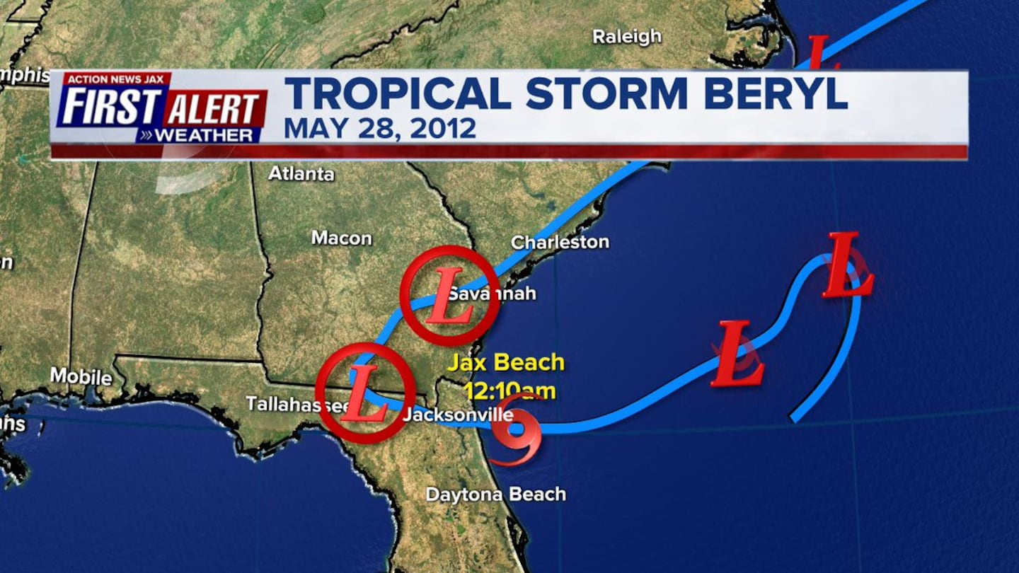
May 28 - May 28: Tropical storm “Beryl” landfall at Jacksonville Beach at 12:10am on Memorial Day - heavy rain & strong winds.
June 7 - 10-15″ of rain causes heavy flooding across Duval, St. Johns & Clay Co.
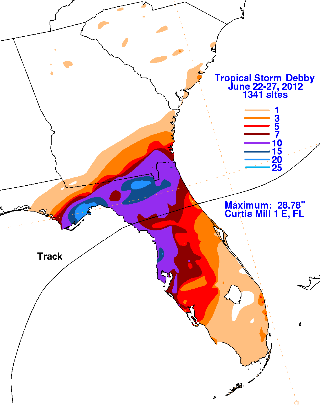
June 24-26 - Tropical storm “Debby” drops 10-20″ of rain across NE Fl. with a 2-day rainfall record at JIA of 12.56″ beating 12.11″ from Sept. 9-10, 1908.
2013
Jan. 30 - 85 degrees at JIA - hottest January day on record (84-Jan. 31, 1982)
May 2-4 - 5-10″ of rain I-95 to the coast
Aug. 1 - EF-2 Arlington tornado injures 1
Dec. 9 - 84 degrees at JIA ties all-time Dec. high temp.
2015
Jan. 8 - Flurries & snow showers across NE Fl.
Oct. 1 - Hurricane Joaquin sinks the El Faro enroute to Puerto Rico from Jacksonville killing 33
Nov. 1 & 3 - 89 degrees in Jax - all-time Nov. record high
2016
Jan. 23 - snow flurries in Jacksonville
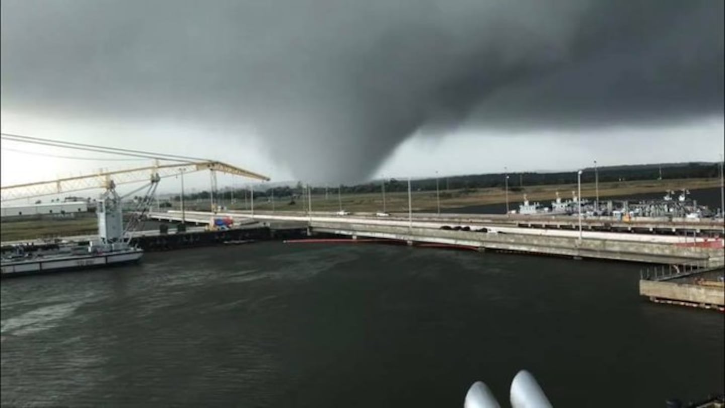
June 6 - Tropical storm Colin spawns an EF-1 tornado on Jacksonville’s Westside (crossed I-10 just west of I-295/I-10)
Aug. 4 - EF-1 tornado near Yulee in Nassau Co. north of Jax

June/July/Aug. - 7.88″ of rain - driest on record (8.71″/1954)
Sept. 2: Cat. 1 hurricane Hermine hits the Panhandle - first Fl. landfalling hurricane since Wilma, 2005
Sept. 13 - Tropical storm “Julia” develops right along the local coast bringing heavy rain from I-95 to the coast.
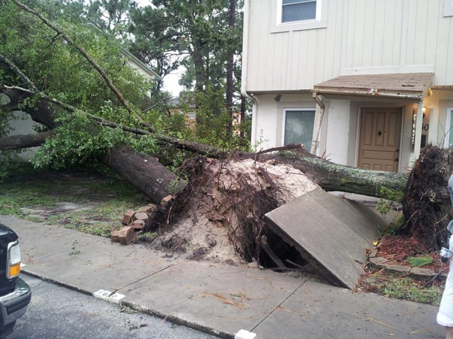
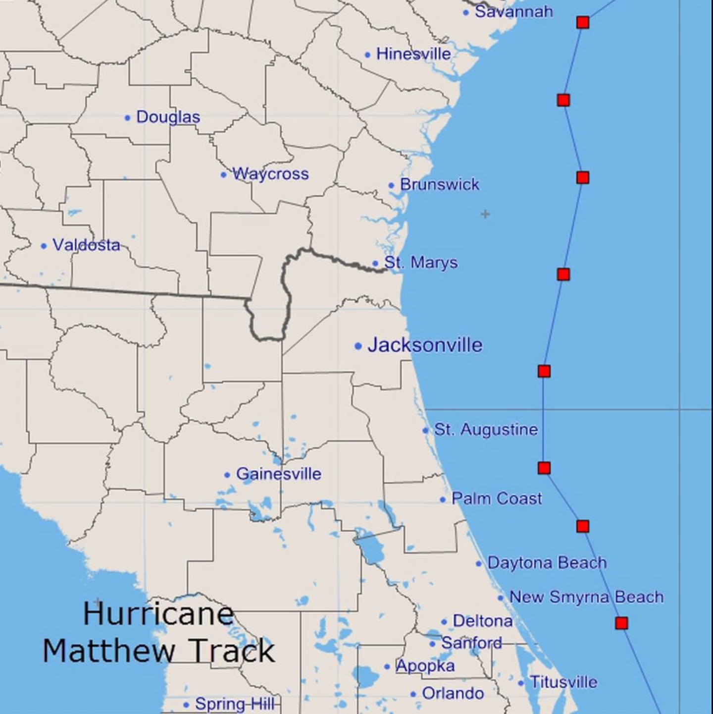
Oct. 7 - Hurricane “Matthew” impacts NE Fl. as the eye passes 45 miles east of Jacksonville Beach with numerous damaged trees & power outages.
2017
Jan. 22 - EF-1 tornado in Camden Co., Ga.
Feb. 7 - EF-1 tornadoes in Lawtey & Heritage Landing, Fl.
April 6 - West Mims fire in Ware Co. ignited by lightning

May - August - wettest on record in Jax - 40.53″ (33.73″ in 1965)
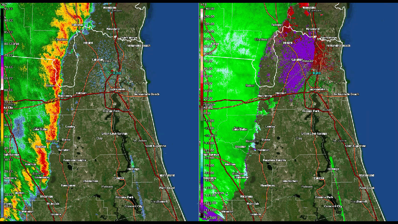
Sept. 10-11 - Hurricane then tropical storm Irma impacts Jax/NE Fl./SE Ga. with very heavy rain, storm surge, flooding & tornadoes.

2018
Jan. 3 - Ice & snow across SE Ga. Pic below - Dixie Union in Ware Co.:

February - Tied warmest on record - 66.1 degrees/+9.7 degrees
Sept. 16 - Hottest Jags home game - 96 degrees with heat index of 106 degrees. Jags beat the Patriots 31-20:

Oct. 10 - Hurricane “Michael” - Cat. 5 hit on the central Fl. Panhandle... spawns EF-0 tornado in Clay Co.

Dec. 2 - EF-3 tornado - Kings Bay, Ga. injures 4
2019
May 3 - Boeing 737 skids into the St. Johns River, NAS Jax during a heavy thunderstorm

May 27 - 100 degrees in Jax ties all-time May record
Oct. 31 - 91 degrees in Jax - latest 90-degree day on record in Jax
Dec. 10 - 85 degrees ties the Dec. all-time record high in Jax.
2020
Jan. 3 - 85 degrees - ties all-time Jan. record high
Feb. 13 - 89 degrees in Jax - all-time Feb. record high (88 degrees in 1962 & 1937)
Sept. 16 - EF-1 tornado in Waycross, Ga.
Dec. 24 - EF-1 Christmas Eve tornadoes in Starke & Baymeadows
2021
July 7 - Tropical storm “Elsa” spawns EF-1 tornado in Jacksonville & Kings Bay, Ga. Pic below along Philips Highway

Dec. 8 - EF-1 tornado in Starke, Fl.
2022
June - record dry 1.17″ of rain at JIA (beating 1.25″ in 1879)
Sept. 29 - Cat. 4 hurricane “Ian” hits Fort Myers, Fl. & brings heavy rain & flooding across Central Florida & St. Johns & Putnam Co.

Nov. 10 - Cat. 1 hurricane “Nicole” makes landfall on the Fl. east coast bringing heavy rain & strong wind to NE Fl./SE Ga.

November - 13 80-degree days is the most on record (11 days in 1961)
2023
Jan. 30 - 87 degrees at JIA - all-time record high for January (old record - 85 degrees)
Jan. - April - 34 days 85 degrees or warmer - a record beating 33 days in 2020
Aug. 30 - Cat. 3 “Idalia” makes landfall at the Fl. Big Bend spawning 3 Camden Co., Ga. tornadoes
Sept. 26 - 16-year old Putnam Co. hunter killed by lightning
Nov./Dec./Jan., 2023-’24: 14.78″ of rain - wettest on record (14/07″/1941-’42)
2024
March 9 - EF-2 Nahunta, Ga. tornado injures 5
April 11 - EF-1 tornado hits World Golf Village neighborhoods
May 10 - Northern lights visible in NE Fl./SE Ga.
June 28 - EF-1 tornado touches down along Beach Blvd. near Southside
Tornado confirmed in Jacksonville as video shows truck flipping multiple times at local business | DETAILS >>> https://t.co/OfrGAD4ah5 pic.twitter.com/SmUNt2HOJV
— ActionNewsJax (@ActionNewsJax) June 28, 2024
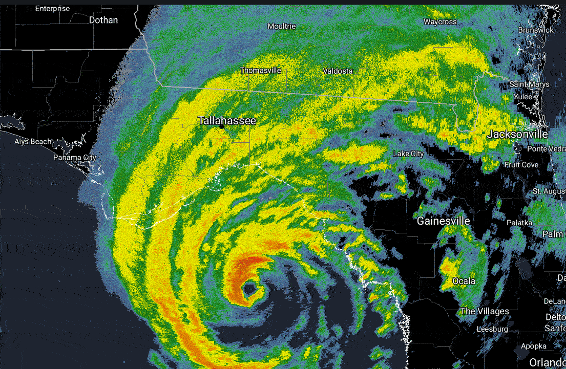
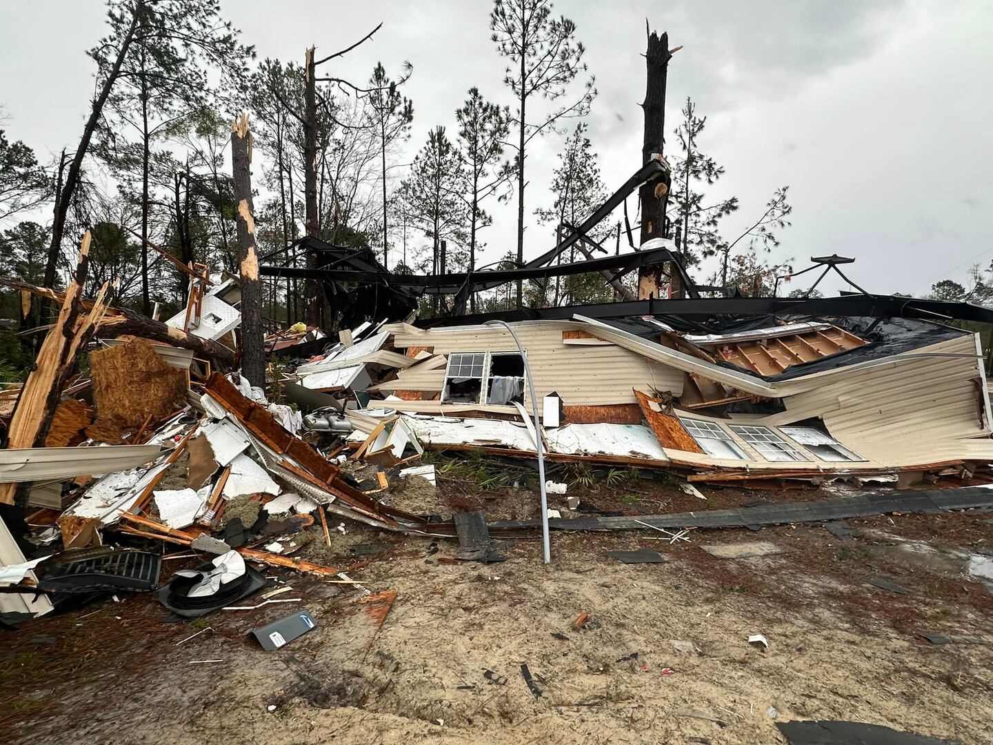
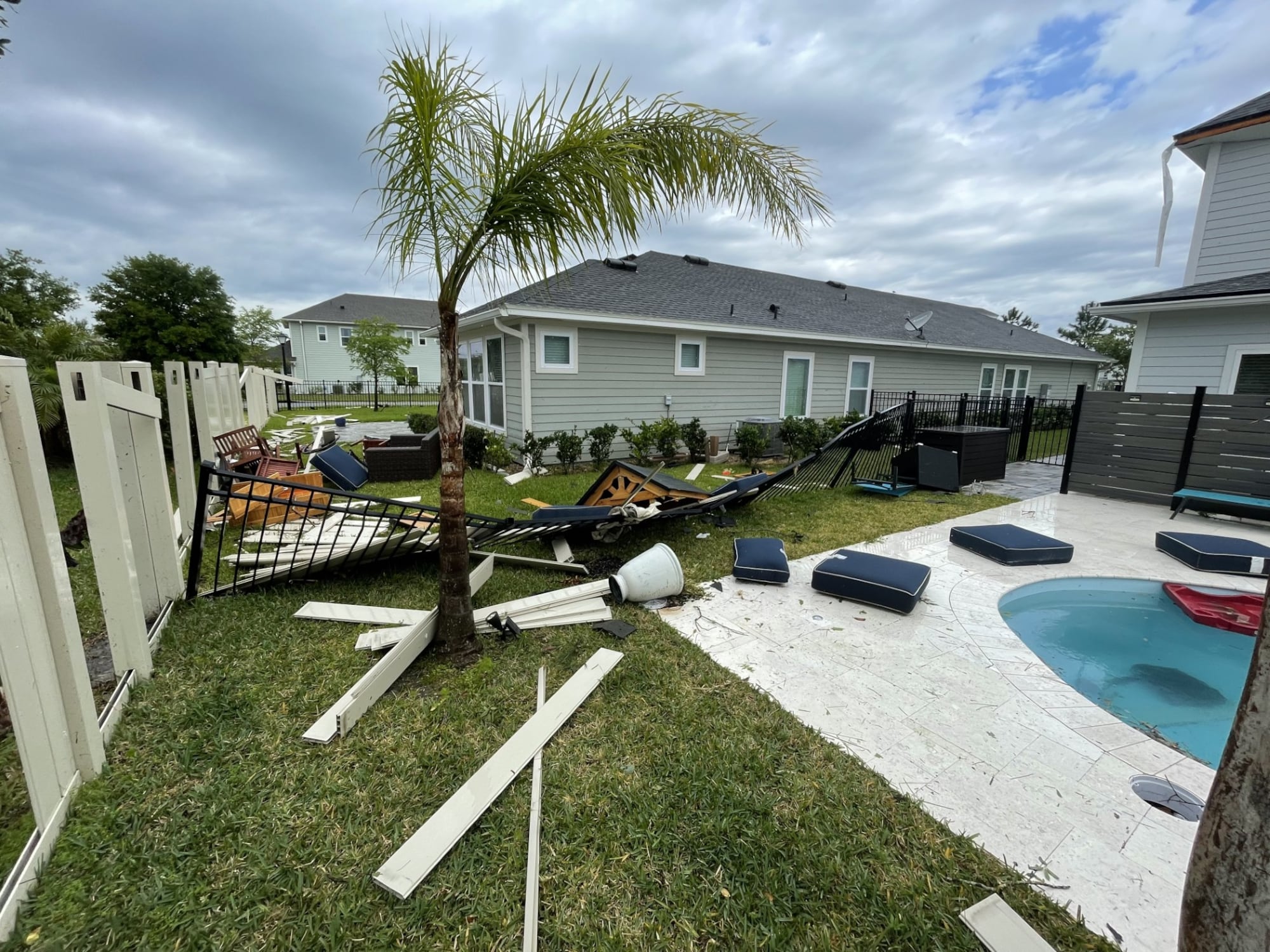
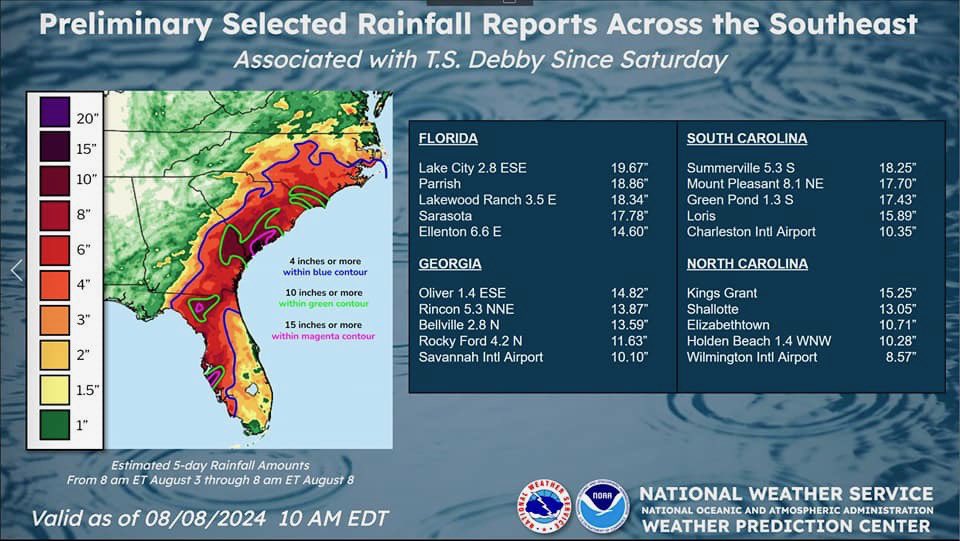
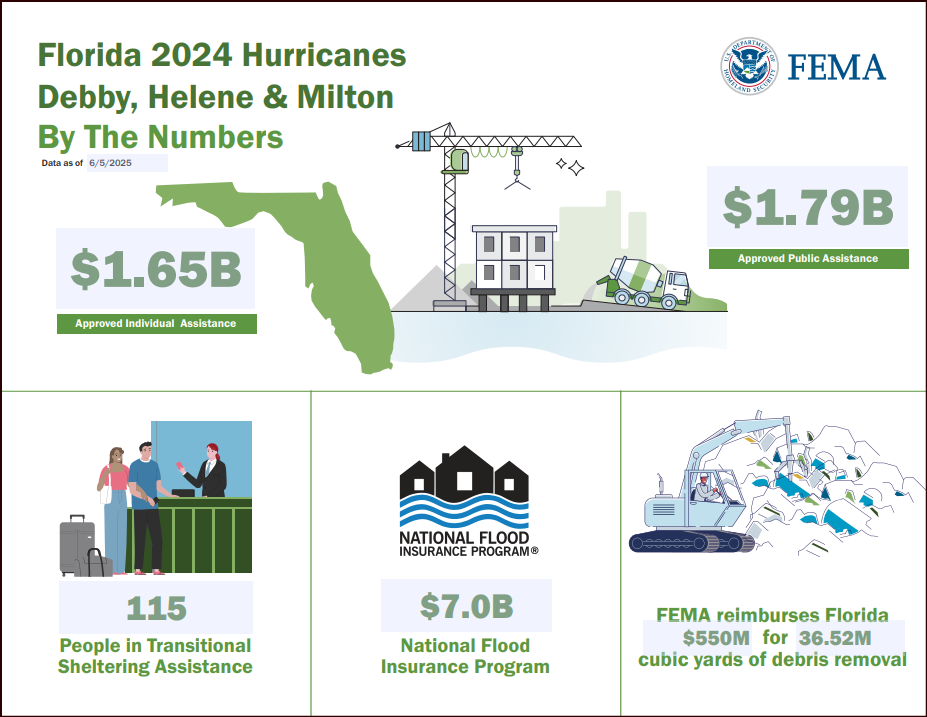
Aug. 5 - Cat. 1 hurricane “Debby” landfall on the Fl. Big Bend drops 4.46″ of rain on JIA
Sept. 12 - Fernandina Beach declares a “State of Emergency” due to flooding

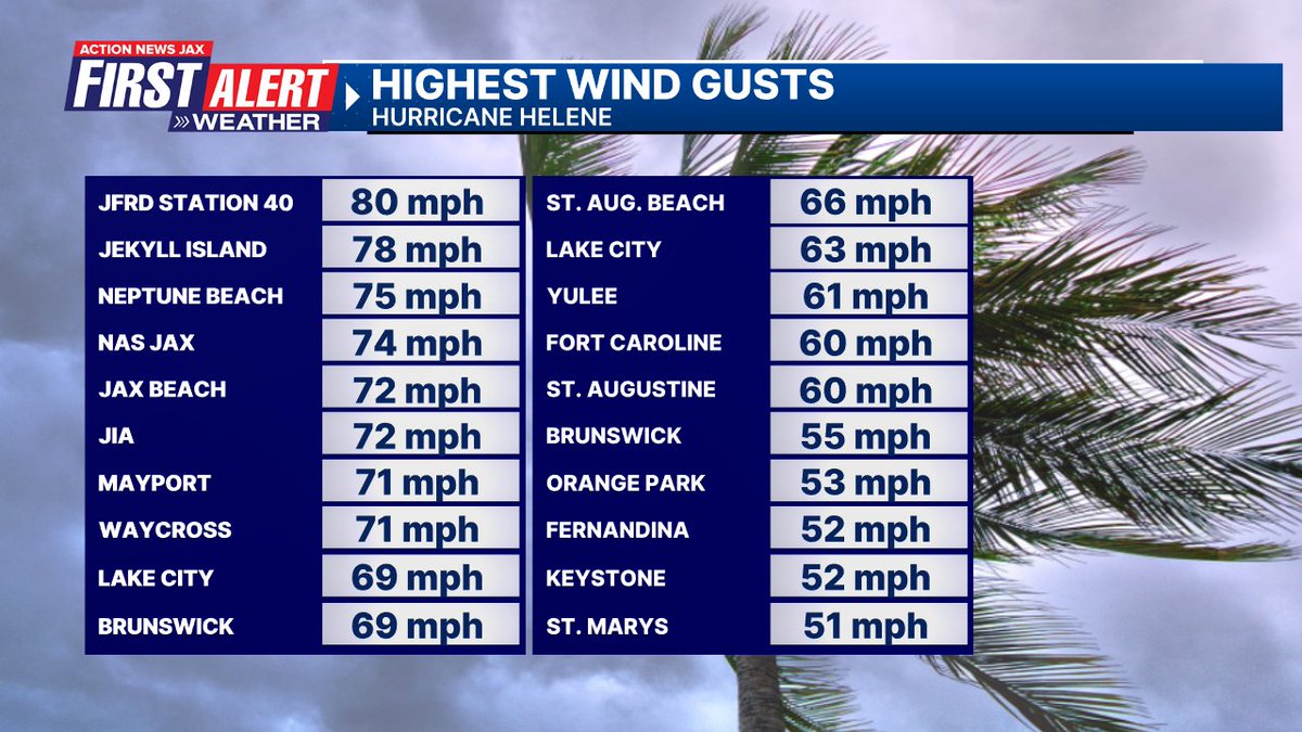
Sept. 26 - Cat. 4 hurricane “Helene” landfall in the Big Bend - power outages & tree damage along I-10 in NE Fl. & much of SE Ga.
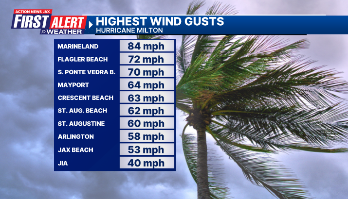
Oct. 9 - Cat. 3 hurricane “Milton” landfall near Tampa Bay brings heavy rain to SE Duval, St. Johns & Putnam Co.
2025
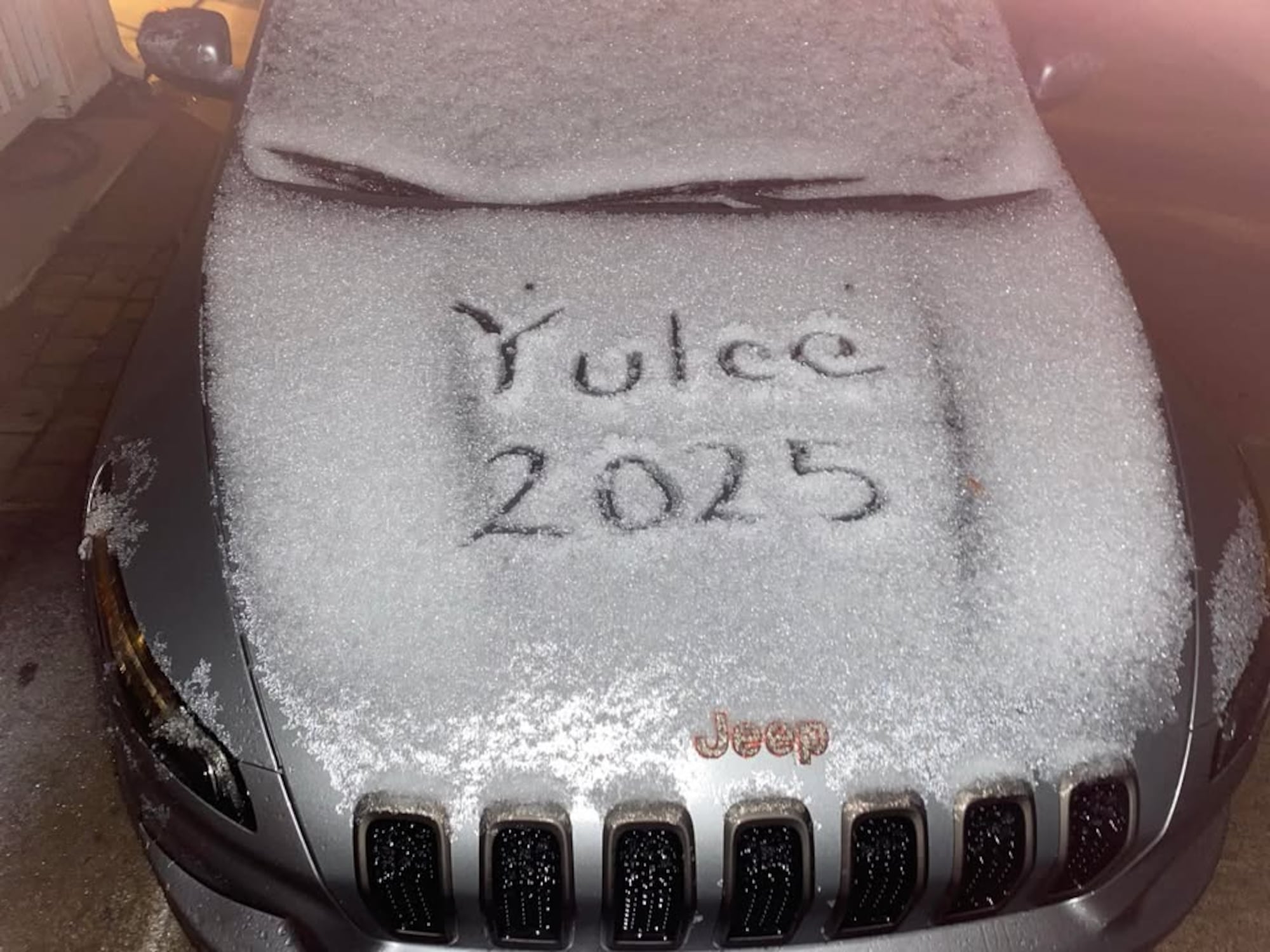
Jan. 22 - 0.1″ of sleet/snow at JIA - 1-4″ of snow across SE Ga.
May - Record number of 90-degree days for the month - 19 - beats record of 17 in 1957, 1953 & 1899
April/May/June - Record avg. max temp. of 88.9 degrees (88.5 degrees in 1981)
July 10 - Two Ware Co., Ga. teenagers killed by lightning while fishing.
Nov. 12 - Northern lights visible in NE Fl. & SE Ga.

November - no rain at JIA - only 2nd time in Jax history going back to 1871 - full month with no rain.


