
Jacksonville, FL — Daily updates on the tropics: “Talking the Tropics With Mike”
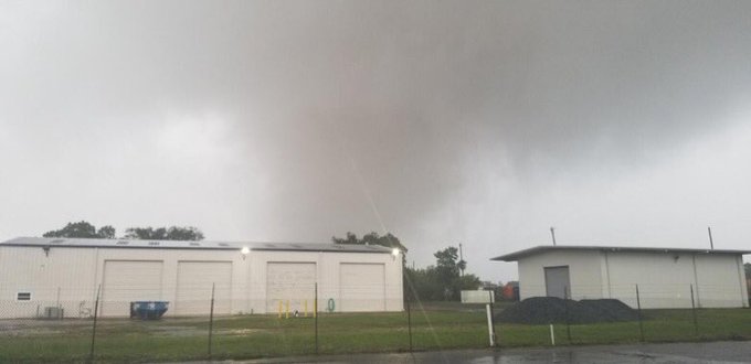
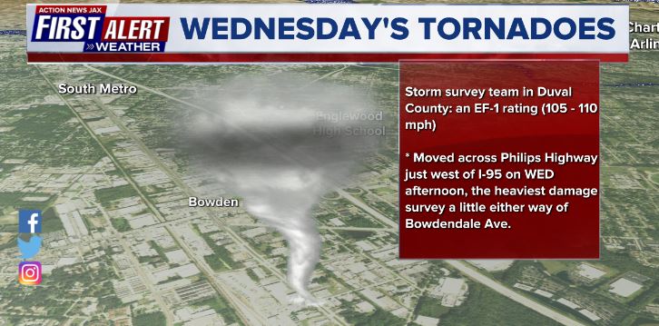
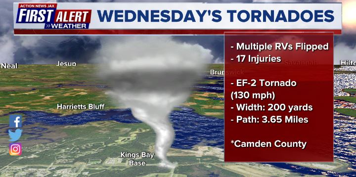
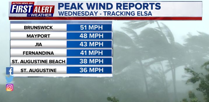
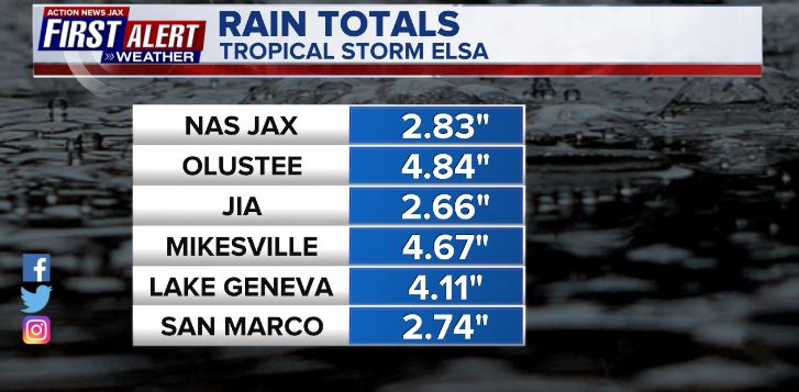
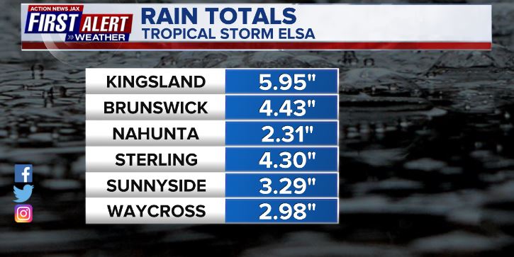
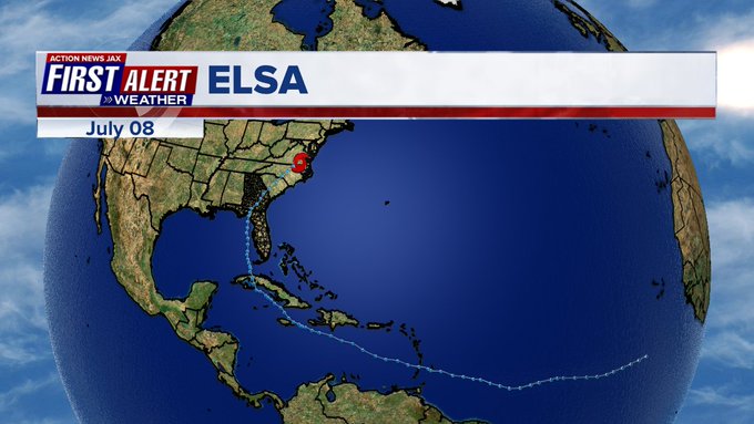
Elsa has left NE Fl./SE Ga., so we can officially “Let it Go”. Unfortunately there was a fatality, injuries & damage. A tree fell on a car in Ortega killing the driver. An EF-1 tornado tore through Duval Co. just east & southeast of downtown a little either way of I-95. An EF-2 tornado hit Camden Co., Ga. from St. Marys to Kings Bay Base injuring 17. Rain was heavy but not so excessive that a lot of flooding occurred. Peak wind gusts were generally 30-50 mph. The NHC final tropical cyclone report on Elsa is * here *.
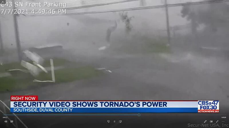
Duval Co. tornado:
Watch security video of the tornado tearing by Cannon in Jacksonville:
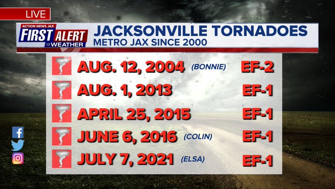
Metro Jacksonville tornadoes over the last 20 years or so includes 3 twisters spawned by tropical cyclones:
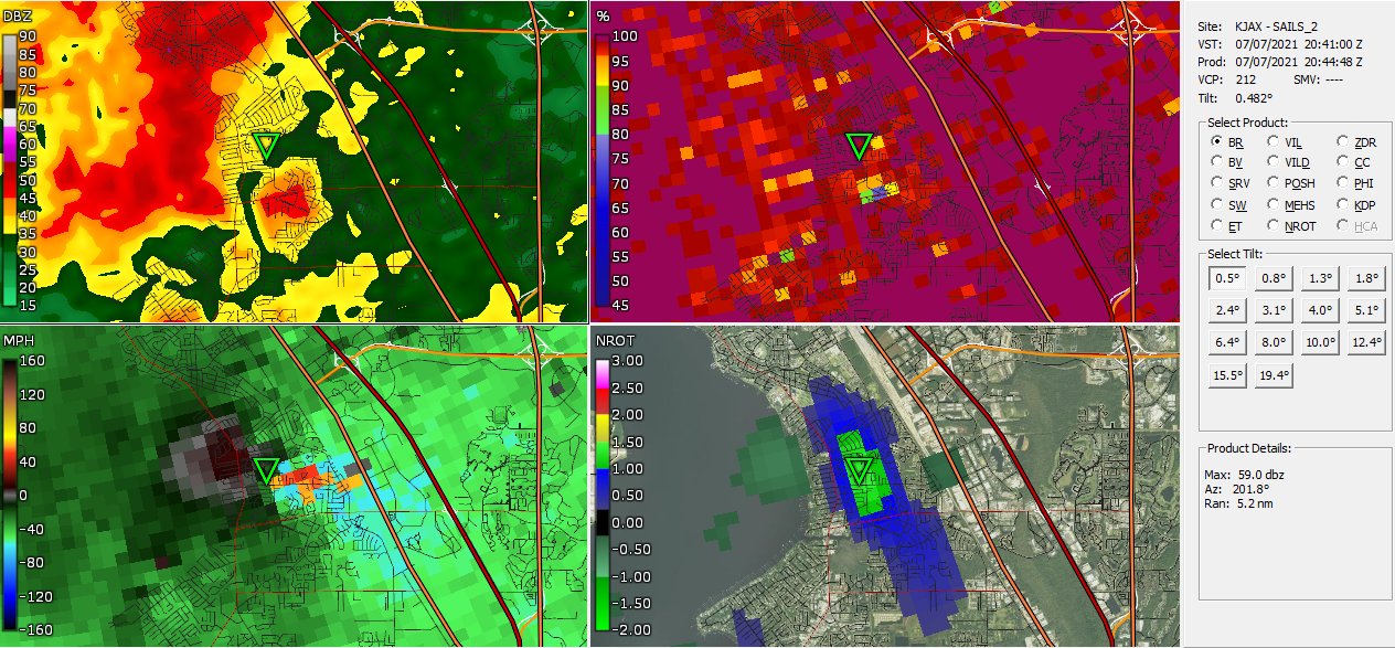
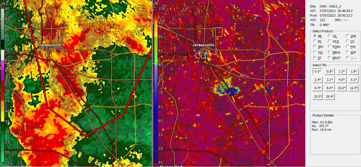
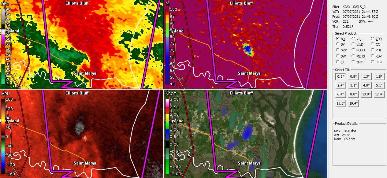
Images below are from our First Alert GR2 Storm Analyst. The first one below shows a classic couplet (circulation with a tornado vortex icon) just west of Philips Highway (LL) as the tornado is forming with - perhaps - a very slight hint of a debris ball (debris rising upward in the atmosphere caused by the tornado) [UR]... & NROT (normalized rotation) which is an alogrithm that can asses rotation in a storm. (The UL is rain intensity [reflecitivity]). Note the 2nd image which shows a much more defined debris ball as the tornado strengthens & does more damage. The last image is the St. Marys/Kings Bay Base tornado with the same properties as indicated in the first image below.
This is about as classic an indication of a tornado on radar one will get in the Jacksonville area.
Elsa was interesting to forecast. The typically reliable European forecast model struggled mightily while the American GFS model did little short of an outstanding job. In the end, moderate shear, some dry air, land interaction & water temps. warm but not excessively so all combined to ultimately limit Elsa’s organization & strength. Still.... Elsa was the fastest on record to the 5th named storm & the farthest east a hurricane has formed (near Barbados) over the Atlantic since 1933. A long track tropical wave strengthening into a tropical cyclone is not common this early in the season. Might be a sign of a busy mid to late season emanating from the deep tropics.
By Brian Tang, University at Albany:

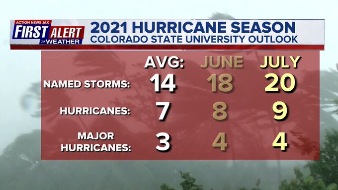
Speaking of the tropics.... Dr. Phil Klotzbach, CSU has issued an update to his seasonal hurricane forecast. The numbers were increased slightly across the board & does include the 5 names (including 1 hurricane) so far. Klotzbach says:
“We have increased our forecast slightly and continue to forecast an above-average 2021 Atlantic basin hurricane season. Current neutral ENSO conditions are anticipated to persist for the next several months. Sea surface temperatures averaged across most of the tropical Atlantic are now near to slightly above normal, and most of the subtropical North Atlantic remains warmer than normal. Elsa’s development and intensification into a hurricane in the tropical Atlantic also typically portends an active season. We anticipate an above-normal probability for major hurricanes making landfall along the continental United States coastline and in the Caribbean. As is the case with all hurricane seasons, coastal residents are reminded that it only takes one hurricane making landfall to make it an active season for them. They should prepare the same for every season, regardless of how much activity is predicted.”
Some never knew such a law existed but Floridians can now drive their car with their hazards on! That’s right - there was a law that a car’s hazard lights could be on/flashing only if stationary. But a new law that took effect July 1 allows for drivers to use their hazards on highways with a speed limit of at least 55 mph “when the conditions create extremely low visibility”.
July night skies (from Sky & Telescope):
July 7-10 (dawn): Look 30 to 45 minutes before sunrise to spot Mercury very low on the east-northeastern horizon.
July 8 (dawn): The Moon, one day shy of new, is 4½° left of Mercury.
July 11 (dusk): The two-day old Moon forms a 6° line with Venus and Mars low on the west-northwestern horizon.
July 12 (dusk): Venus and Mars are within ½° of one another, while the crescent Moon hovers at upper left.
July 16 (evening): The waxing crescent Moon is in Virgo, roughly 6° from Spica.
July 19 (evening): The waxing gibbous Moon is 1° from Beta (β) Scorpii in the Scorpion’s claws. Antares is lower left of the pair.
July 21 (dusk): Venus shines brightly in deepening twilight and is about 1° from Regulus in Leo.
July 23 (night): The Moon, one day past full, and Saturn form a graceful vertical pair low in the southwest before sunrise. Jupiter hovers nearby at upper left.
July 24 (night): The waning gibbous Moon forms a shallow arc with Jupiter and Saturn.
July 25 (night): The Moon and Jupiter hang 5° apart with Saturn to their right.
July 28–29 (all night): The modest Southern Delta Aquariid meteor shower peaks; a waning gibbous Moon will interfere with viewing.
Aug. 1–2 (all night): Saturn arrives at opposition, opposite the Sun in the sky. It rises at sunset and sets at sunrise.
Aug. 11–12 (all night): The Perseid meteor shower reaches maximum; the waxing crescent Moon won’t interfere with viewing. Expect up to 1 meteor per minute from a dark location with minimal light pollution.
Moon Phases
Last Quarter – July 1, 5:11 p.m. EDT
New Moon – July 9, 9:17 p.m. EDT
First Quarter – July 17, 5:11 a.m. EDT
Full Moon – July 23, 10:37 p.m. EDT
(Full Buck Moon, named for emergence of antlers on buck deer)
Last Quarter – July 31 9:16 a.m. EDT
©2021 Cox Media Group


