:quality(70)/cloudfront-us-east-1.images.arcpublishing.com/cmg/4BY52YP3URHB3CBG6342FEUNGQ.jpg)
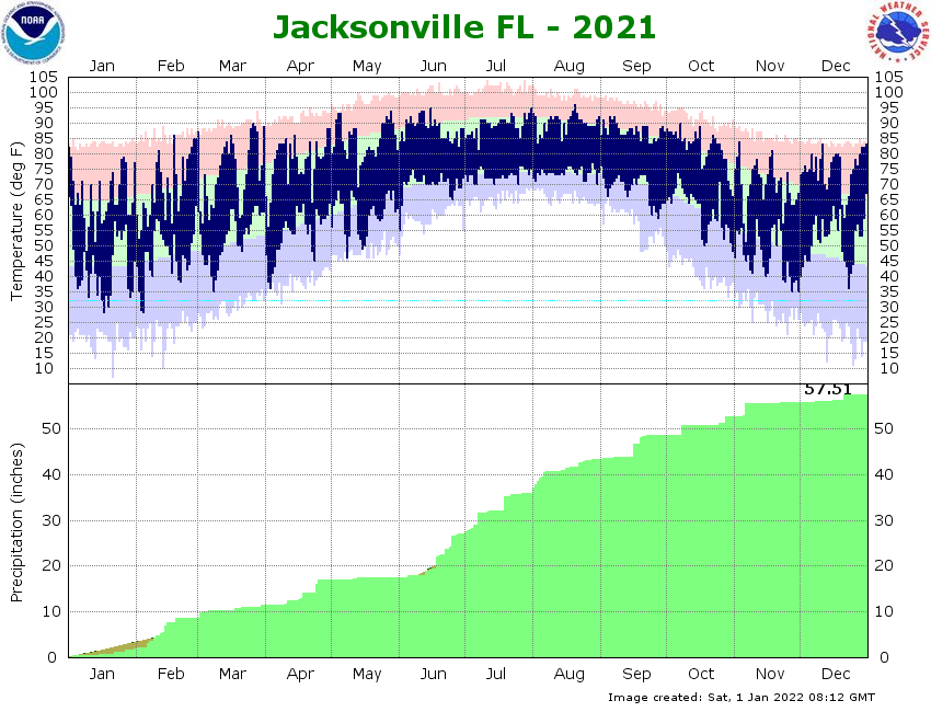
Jacksonville, FL — Jacksonville fared well through late winter & much of spring when it came to timely rainfall. But the typical peak of the wildfire season is rearing its ugly head as NE Fl. & SE Ga. have quickly dried out over the last couple of weeks. The so-called wet season usually kicks in during June but the infamous 1998 wildfire season raged into early July. For the entire year, Jacksonville is still more than 2″ above avg.... but more than 2″ below avg. for May.
The wildfire below ignited Tue., May 25th about 10 miles southeast of Waycross.


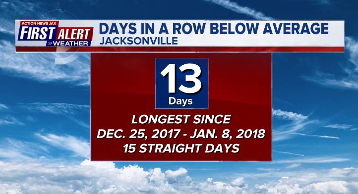
While drying out, May has been nice & cool including many nights in the 40s & 50s. May 26th marked the first day with above avg. temps. in 2 weeks. The 13 straight days below avg. was the longest such stretch since mid winter of 2017-’18.

Spring through summer into fall are dangerous for ocean activities & exercise given warmer ocean water & a lot more people headed to the beaches. Rip currents are known as the “silent killer” because many victims fall prey to “rips” on what appear to be gorgeous, sunny days. There were two deaths on our coastline on May 22nd & 24th respectively. Remember to never swim or surf alone & always as near a lifeguard as possible. Try not to panic & realize the “grip of the rip” will let go relatively quickly, & you’ll be able to get back to shore & safety by swimming parallel to the shore while gradually working toward the beach (vs. going straight back to the beach & risking getting caught up in the rip current again).
NOAA has developed the first national rip current forecast model - go * here *. The First Alert weather team will also issue these forecasts during each forecast. According to NOAA:
For the first time, NOAA is launching a national rip current forecast model, aimed at saving lives of beach-goers around the country. This new model can predict the hourly probability of rip currents along U.S. beaches up to six days out.
NOAA’s National Ocean Service and National Weather Service collaboratively developed and implemented the model, which leverages wave and water level information from the recently upgraded National Weather Service’s Nearshore Wave Prediction System. Similar to predicting weather or precipitation, the model predicts the likelihood of dangerous seaward currents on a sliding scale - from 0 to 100%.
The forecast model covers a majority of the U.S. East and Gulf Coast and portions of California, Hawaii, Guam and Puerto Rico. Additional coastline coverage will be expanded in the future.
“Rip currents account for an estimated 100 deaths in the United States each year,” said Gregory Dusek, NOAA scientist who developed the model. “Before this, forecasters were manually predicting rip currents on a large section of the ocean twice a day and only a day or two into the future. The earlier prediction has potential to substantially increase awareness and reduce drownings.”
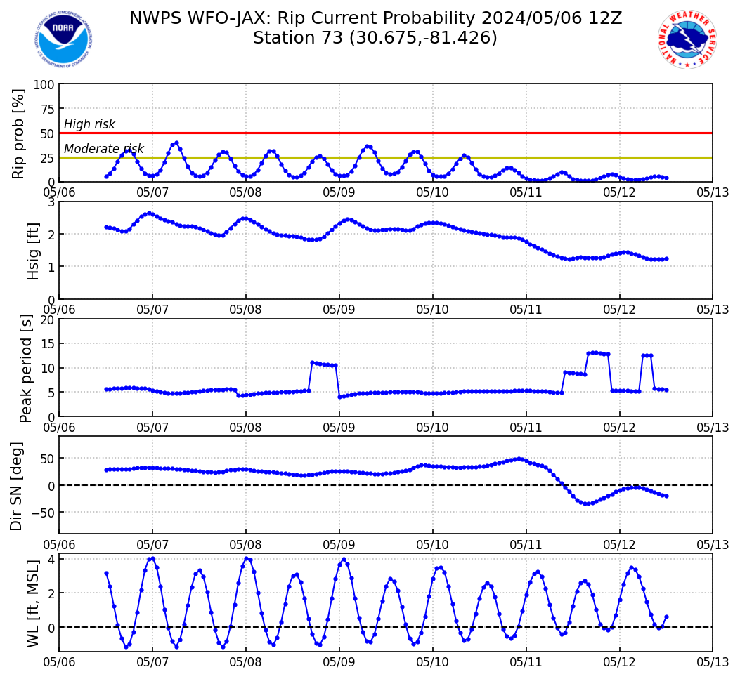
Here’s an example of a plot for Fernandina Beach (realize there can be rip currents on “low risk” days):

From the St. Johns Chamber of Commerce - “Ponte Vedra Naturally”:
May 26, 2021--The St. Johns County Chamber of Commerce is proud to announce the launch of a new website designed to showcase the host of natural assets found in the Ponte Vedra Beach, Ponte Vedra, and Palm Valley communities in St. Johns County.
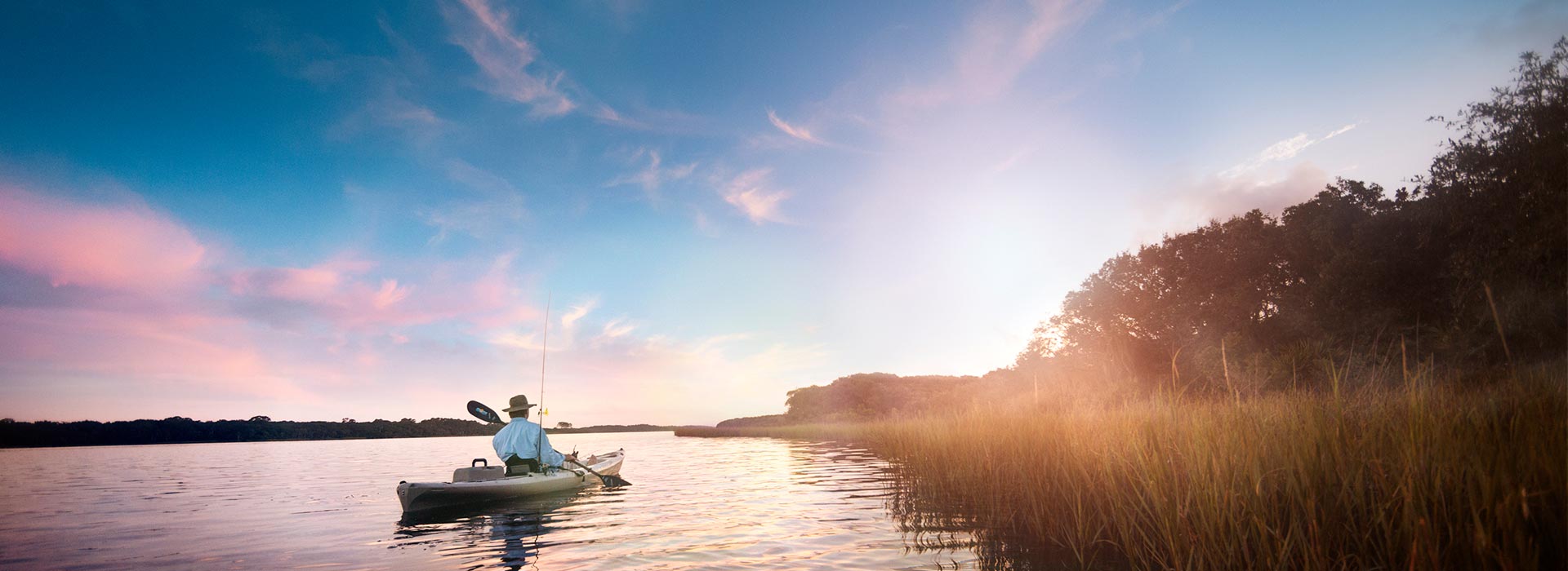
Depicting five activities under five different themes, the website can be found at http://www.pontevedranaturally.com. The five themes are Hiking, Biking, Kayaking, Birding and Fishing.
“The intent of the site is to offer visitors additional attractive experiences beyond golf and history enticing them to extend their stay in our county which in turn brings more revenue to our community,” explained Isabelle Renault, president and CEO, St. Johns County Chamber of Commerce. “Our research shows that 81% of overnighters visiting our region are at the front door of Ponte Vedra but never make it to the destination and only 13 percent of day visitors coming to St. Johns county experienced Ponte Vedra.”
The members of the Naturally Ponte Vedra Product Development Working Group met to decide on the themes and direction of the site. The main proponents of the site are the GTM Research Reserve, the St. Augustine/Ponte Vedra & The Beaches Visitors and Convention Bureau, the St. Johns County Tourist Development Council, St. Johns County Cultural Council and the St. Johns County Chamber of Commerce.
It can be easy to overlook the array of natural assets in this area. “The timing of the launch of this website couldn’t be better,” explained Renault. “After more than a year of stress and isolation, now is the time to explore the outdoors. This area is not defined by busy highways, but by the many planned pockets of natural paradise. The region features miles of ocean shoreline, acres of intracoastal waterways and lakes, a Wildlife Management area and one of the country’s protected estuarine reserves at the GTM Research Reserve.”
While the website is intended to promote and convey outdoor activities for visitors, it was critical that all these activities be appealing for our residents to enjoy. For more information call the Ponte Vedra Beach Division of the St. Johns County Chamber of Commerce at 904-285-2004 or visit the Ponte Vedra Beach Visitor Information Center at 200 Solana Road, Ste. B in Ponte Vedra Beach.
©2021 Cox Media Group
:quality(70)/d1hfln2sfez66z.cloudfront.net/04-24-2024/t_d73855398dca4bf5a6e1eca4fedb0fdd_name_file_960x540_1200_v3_1_.jpg)
:quality(70)/cloudfront-us-east-1.images.arcpublishing.com/cmg/ZNROW6TVSVGMXJTMBWQ2FDXXZI.jpg)
:quality(70)/cloudfront-us-east-1.images.arcpublishing.com/cmg/UPSNZVHYKZE2VDSCN54C3FTF5E.png)
:quality(70)/cloudfront-us-east-1.images.arcpublishing.com/cmg/FSI6PQUNDBFDBDPMRHY7IIPE7E.jpeg)
:quality(70)/cloudfront-us-east-1.images.arcpublishing.com/cmg/HXQ7KYK2Q5FANGIO52PBGE5GBE.jpg)